


Displaying items by tag: Gormanston
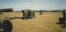
The Department of Transport says it is advised that the Air Corps will conduct air-to-ground air firing exercises in the Gormanston D1 Air Range in Co Meath next Thursday 27 and Friday 28 October.
Live firing will take place on the Thursday between noon and 9pm and on the Friday between 11am and 4pm IST.
Marine Notice No 72 of 2022 says an Activation Notice (Danger Area D1 – Gormanston) will be issued.
The officer in charge of firing on each day will be fully briefed regarding communication between the firing point and the Air Traffic Control Centre at Dublin Airport. The Naval Service or Air Corps RHIB will enforce an exclusion zone.
Contact details are available in Marine Notice No 72 of 2022, attached below.
The Air Corps advises that it will conduct air-to-ground and air-to-air firing exercises in the Gormanston D1 Air Range in Co Meath this week.
Mariners in the Irish Sea off Co Meath are given due warning that live firing will take place daily between 9am and 5pm from tomorrow, Tuesday 26 to Friday 29 April.
An Activation Notice (Danger Area D1 – Gormanston) was issued last week, as previously reported on Afloat.ie.
The officer in charge of firing on each day will be fully briefed regarding communication between the firing point and the Air Traffic Control Centre at Dublin Airport.
In addition, the Naval Service will provide a patrol vessel to enforce the exclusion zone in the Irish Sea.
Marine Notice: Air-To-Ground Shoot At Gormanstown Air Defence Range
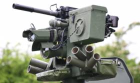
#MarineNotice - The Defence Forces advise that they will conduct an Air Firing (Air to Ground) Shoot at Gormanston Ranges from Monday 28 August to Saturday 9 September, excluding Saturday 2 and Sunday 3 September, between 9am and 5.30pm each day.
The danger area (EID1) comprises the lands of Gormanston Aerodrome and the air and sea areas contained within a radius of three nautical miles centred on aerodrome.
This includes an additional area contained within a segment centred on Gormanston Aerodrome and bearing of 015º degrees true, through Mosney Railway Station and 106º degrees true, through Gormanston Railway Station seawards for a distance of 10 nautical miles.
For the periods while the range is active, the sea zone within the danger area is out of bounds to all vessels.
A Naval Service patrol vessel will enforce the exclusion zone ‘D1’ as indicated on UKHO Chart No 44.
All vessels are advised that they are required to remain outside of the exclusion zone whilst the range is active. Vessels are also recommended to carefully monitor the Radio Navigation Warnings that will be broadcast during the firing period.
#Gormanston - The Air Accident Investigation Unit is probing the circumstances surrounding the death of a man in his 40s in a paragliding accident off Gormanston in Co Meath yesterday evening (Sunday 5 June), according to RTÉ News.
The man, who was flying an engine-driven glider, crash landed in shallow water near the Defence Forces camp around 6pm and died shortly thereafter in spite of the best efforts of emergency services and members of the public, as Independent.ie reports.
Marine Notice: Air-To-Ground Shoot At Gormanston Ranges

#MarineNotice - Following April's air defence shoot, the Defence Forces will be conducting an air-to-ground shoot at Gormanston Ranges between 16 and 28 May (excluding Sunday 22 May) from 10am to 6pm each day.
The danger area (EID1) comprises the lands of Gormanston Aerodrome and the air and sea areas contained within a radius of three nautical miles centred on Gormanston Aerodrome.
An additional area is contained within a segment centred on Gormanston Aerodrome and bearing of 015º degrees true, through Mosney Railway Station and 106º degrees true, through Gormanston Railway Station seawards for a distance of 10 nautical miles.
For the periods while the range is active, the sea zone within the danger area is out of bounds to all vessels. A Naval Service patrol vessel will enforce the exclusion zone ‘D1’ as indicated on UKHO Chart No 44.
All vessels are advised that they are required to remain outside of the exclusion zone while the range is active. Vessels in the area are recommended to carefully monitor the Radio Navigation Warnings that will be broadcast during the firing period.
The Department of Transport, Tourism and Sport has been advised by the Defence Forces that they will conduct an Air Defence Shoot at Gormanston Ranges on the following dates;
Range active:
7th and 8th April 2016
Time: 10:00 to 12:00 Hours
The danger area comprises the lands of Gormanston Aerodrome and the Air and Sea areas contained within a radius of 3 nautical miles centred on Gormanston Aerodrome, with an additional area contained within a segment centred on Gormanston Aerodrome and bearing of 015º degrees true, through Mosney Railway Station and 106º degrees true, through Gormanston Railway Station seawards for a distance of 10 nautical miles. For the periods whilst the Range is active, the sea zone within the danger area is excluded to all vessels.
A Naval Service patrol vessel will enforce the exclusion zone. The exclusion zone ‘D1’ is indicated on UKHO Chart No. 44.
All vessels are advised that they are required to remain outside of the exclusion zone whilst the Range is active.
All vessels in the area are recommended to carefully monitor the Radio Navigation Warnings that will be broadcast during the firing period. Irish Maritime Administration,
Department of Transport, Tourism and Sport, Leeson Lane, Dublin 2, Ireland, D02 TR60.

Marine Notice No. 48 of 2013
Notice to all Shipowners, Fishing Vessel Owners, Agents, Shipmasters, Skippers, Fishermen, Yachtsmen and Seafarers
Live Surface to Air Firing Practices –
Gormanston Air Defence Range, Co. Meath.
The Department of Transport, Tourism and Sport has been advised by the Defence Forces that they will conduct live Surface to Air firing practices on the following date;
Range active:
Dates: 22 nd and 23 rd October 2013
Time: 11:30 to 15:30 Hours
The danger area comprises the lands of Gormanston Aerodrome and the Air and Sea areas contained within a radius of 3 nautical miles centred on Gormanston Aerodrome, with an additional area contained within a segment centred on Gormanston Aerodrome and bearing of 015º degrees true, through Mosney Railway Station and 106º degrees true, through Gormanston Railway Station seawards for a distance of 10 nautical miles.
For the periods whilst the Range is active the sea zone within the danger area is excluded to all vessels.
A Naval Service patrol vessel will enforce the exclusion zone. The exclusion zone 'D1' is indicated on British Admiralty Chart No. 44.
All vessels are advised that they are required to remain outside of the exclusion zone whilst the Range is active.
All vessels in the area are recommended to carefully monitor the Radio Navigation Warnings that will be broadcast during the firing period.
Irish Maritime Administration,
Department of Transport, Tourism and Sport,
Leeson Lane, Dublin 2, Ireland.
For any technical assistance in relation to this Marine Notice, please contact:
The Marine Survey Office, Leeson Lane, Dublin 2, tel: +353-(0)1-678 3400.
For general enquiries, please contact the Maritime Safety Policy Division, tel: +353-(0)1-678 3418.
Written enquiries concerning Marine Notices should be addressed to:
Maritime Safety Policy Division, Dept. of Transport, Tourism and Sport, Leeson Lane, Dublin 2, Ireland.
email: [email protected] or visit us at: www.dttas.ie
Marine Notice No. 31 of 2013 - Live Surface to Air Firing Practices - Gormanston Air Defence Range

Notice to all Shipowners, Fishing Vessel Owners, Agents, Shipmasters, Skippers, Fishermen, Yachtsmen and Seafarers
Live Surface to Air Firing Practices –
Gormanston Air Defence Range, Co. Meath.
The Department of Transport, Tourism and Sport has been advised by the Defence Forces that they will conduct live Surface to Air firing practices on the following date;
Range active:
17 th July 2013
Time: 11:30 to 13:30 Hours
The danger area comprises the lands of Gormanston Aerodrome and the Air and Sea areas contained within a radius of 3 nautical miles centred on Gormanston Aerodrome, with an additional area contained within a segment centred on Gormanston Aerodrome and bearing of 015º degrees true, through Mosney Railway Station and 106º degrees true, through Gormanston Railway Station seawards for a distance of 10 nautical miles. For the periods whilst the Range is active the sea zone within the danger area is excluded to all vessels.
A Naval Service patrol vessel will enforce the exclusion zone. The exclusion zone 'D1' is indicated on British Admiralty Chart No. 44.
All vessels are advised that they are required to remain outside of the exclusion zone whilst the Range is active.
All vessels in the area are recommended to carefully monitor the Radio Navigation Warnings that will be broadcast during the firing period.
Director General,
Maritime Safety Directorate,
Department of Transport, Tourism and Sport,
Leeson Lane, Dublin 2, Ireland.
For any technical assistance in relation to this Marine Notice, please contact:
The Marine Survey Office, Leeson Lane, Dublin 2, tel: +353-(0)1-678 3400.
For general enquiries, please contact the Maritime Safety Policy Division, tel: +353-(0)1-678 3418.
Written enquiries concerning Marine Notices should be addressed to:
Maritime Safety Directorate, Department of Transport, Tourism and Sport, Leeson Lane, Dublin 2, Ireland.
email: [email protected] or visit us at: www.dttas.ie
04/07/2012
Whale Rescued In Meath Stranding Drama
#MarineWildlife - Skerries RNLI joined a number of groups in assisting a beached whale back out to sea at Gormanston in Co Meath earlier today (Thursday 20 June).
The volunteer lifeboat crew launched their inshore lifeboat shortly after 10am following reports from the Irish Whale and Dolphin Group (IWDG) that a 25ft pilot whale had beached in the area.
The lifeboat helmed by Joe May, and with crew members Emma Wilson, AJ Hughes and Laura Boylan onboard, made its way to the scene where May got into the sea and helped manoeuvre the whale back into deeper water.
Skerries RNLI then shadowed the whale guiding it out to sea, preventing it from turning back to shore by positioning the boat in its way. The lifeboat did this for about 25 minutes until the mammal was well clear of the shore.
Other agencies on scene included Skerries coastguard, the Defence Forces based at Gormanston, the IWDG, Boyne Fishermen’s Rescue and Irish Coast Guard helicopter Rescue 116.
Meanwhile, RTÉ News reports that a second whale was found dead on the beach near Mornington, north of Bettystown.
Despite initial fears that the whale was the same one rescued in the morning, it was later determined to be a different creature.
Marine Notice: Firing Exercises Off Gormanston & Survey Equipment in Galway Bay
#MARINE WARNING - Seafarers are advised to steer clear of upcoming surface-to-air firing exercises off north Co Dublin, as well as a survey equipment deployment operation in Galway Bay.
Marine Notice No 51 of 2012 outlines that the Defence Forces will be conducting live surface-to-air firing practices at Gormanston Air Defence Range in Co Meath this week on Wednesday 19 and Thursday 20 September from 11am to 3pm each day.
Similar to the exercises conducted this past July, an exclusion zone will be established comprising the land, air and sea areas contained within a radius of three nautical miles centred on Gormanston Aerodrome, with an additional segment centred on the aerodrime and bearing of 015 degree true through Mosney rail station and 106 degrees true through Gormanston rail station seawards for a distance of 10 nautical miles.
The exclusion zone D1 will be enforced by a Naval Service vessel. All mariners in the area are required to remain outside the exclusion zone while the range is active, and are recommended to carefully monitor the radio navigation warnings that will be broadcast throughout the firing period.
Meanwhile, in Galway Bay two Benthic Lander devices will be deployed between 24 and 26 September, to be recovered between 29 and 31 September.
The national research vessel R/V Celtic Voyager (call sign EIQN) - which will host the Science@Sea marine science training scheme this coming November - will carry out the deployment of the 2-3-metre high devices that will monitor sediment movement, current speed and direction, and wave motion at depth.
All vessels, particularly those engaged in fishing, are requested to give the vessel and wide berth of at least 500 metres and keep a sharp lookout.
Details of relevant co-ordinated are included in Marine Notice No 52 of 2012, a PDF of which is available to read or download HERE.


. He learned his sailing in the Royal Cork at Crosshaven but left Ireland (as did many others) in 1985 and is now so into America’s West Coast sailing scene that he owns a classic Cal 40")


 Michael Murphy Schull Harbour Sailing Club (SHSC), Eric Coogan Heineken Ireland, Mark Murphy, Commodore SHSC, Jack Allen SHSC, Carmel O'Regan SHSC, Cornelious Ndlovu, Schull Harbour Hotel Operations Manager and Derval Murphy SHSC")

