Menu

Ireland's sailing, boating & maritime magazine

Displaying items by tag: Hydrographic

The first in a series of hydrographic and geophysical surveys to be undertaken in the Celtic Sea and Atlantic Ocean under the INFOMAR programme between April and October 2019 is now under way.

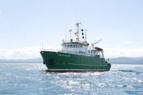
The RV Celtic Voyager (callsign EIQN) set off on Friday 12 April for an 18-day survey, the first of four over the next five months 18 May-6 June, 12-28 July, 29 August-14 September).

The RV Celtic Explorer (callsign EIGB) will follow up with an 18-day survey from 21 September to 8 October. Both vessels will be towing a magnetometer sensor with a single cable of up to 200 metres in length.

Other survey vessel involved include the Geological Survey Ireland vessels RV Keary (callsign EI-GO-9), RV Geo (callsign EI-DK-6), RV Mallet (callsign EI-SN-9) and RV Lir (callsign EI-HI-2).

All will display appropriate lights and markers and will be listening on VHF Channel 16 throughout the course of the surveys.

Full details of the survey areas are included in Marine Notice No 8 of 2019, a PDF of which is available to read or download HERE.

Published in Marine Science
High Resolution images of a merchant ship which was sunk ninety-four years ago today (October 12th) off the coast of Dublin have been revealed by the INFOMAR (Integrated Mapping For the Sustainable Development of Ireland's Marine Resource) Programme during a mission on the national research vessel the RV Celtic Voyager earlier this year which surveyed the wreck of the first Guinness merchant vessel, the W.M. Barkley.

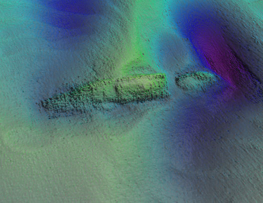
The detailed seabed images, which include deck features and complex sand wave structures, were recorded by towed sidescan sonar provided by the Moore Marine Group, and give a visual insight into the defensively armed ship that was sunk by a German torpedo in 1917, seven miles east of the Kish Bank off Dublin.

Photo_1_INFOMAR_image_of_W_M_Barkley_from_port_aft

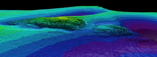
Photos above and below show topographic seafloor images in 3D, showing the partially buried wreck of the W M Barkley lying at a water depth of 56 metres; with deeper scouring around it down to 72 metres (darker colours indicate greater depths). The images were created from sonar data acquired onboard the Marine Institute's research vessel RV Celtic Voyager, during INFOMAR Programme mapping in 2010 and 2011 with data processed by INFOMAR's Fabio Sacchetti (University of Ulster) and Charise McKeon (Geological Survey of Ireland).

W_M_Barkley

In May 2010, during a large scale mapping survey in the Irish Sea by INFOMAR, a national marine study run by the Marine Institute and the Geological Survey of Ireland, identified a seabed feature which, to the trained eye, was discernable as a potential shipwreck lying in the same position recorded on the Admiralty Chart, the EU wreck site and UK Hydrographic Office wreck site directories, as well as a survey conducted in the 1980s as the last known position of the W.M.Barkley.

Viewing the spectacular imagery of the shipwreck Minister for Communications, Energy & Natural Resources, Pat Rabbitte, said "I am delighted to note the continued excellence of the valuable work being carried out under the INFOMAR project. These images from the deep reveal a unique view of part of Ireland's marine heritage and I am delighted to announce details of INFOMAR''s annual seminar to be held in Galway on November 16 and 17th."

Photo_3_Guinness_Archivist_Eibhlin_Roche_with_model_of_WM_Barkley

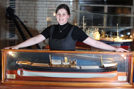
Eibhlin Roche - Guinness Archivist, Guinness Storehouse with the model of the W.M. Barkley. Photo: Jason Clarke Photography

Ninety four years ago on the dark night of October 12th 1917 the W.M.Barkley was torpedoed without warning by the German submarine UC-75. Within minutes the ship, which was owned and operated by the Guinness Company of Dublin, broke in two and sank, taking with her to the bottom four men including her Captain and leaving the rest of her crew to face the sea in an open lifeboat. Now, the darkness where the ship has lain in pieces has been disturbed, probed by fingers of sound that are mapping the seabed in incredible details and bringing to light the position of this famous Irish shipwreck.

"As the first Guinness owned ship, the W.M. Barkley played an important role in the story of the transportation of GUINNESS beer overseas," said Eibhlin Roche, Guinness Archivist. The events of the night of 12th October 1917 are very much part of the history of Guinness that is recorded in the Guinness Archive. It is exciting to finally know the exact resting place of the W.M. Barkley."

A scale model of the W.M. Barkley is on display in the Transport Gallery of Guinness Storehouse remembering the lives of the Guinness men who both perished and survived the events of 12th October 1917. These are stories of tragedy and bravery portraying Irish traditional values, and how they were brought to light with the application of cutting-edge technology.

Koen_Verbruggen_Minister_Rabbitte_Dr_Peter_Heffernan_Eibhlin_Roche_and_David_Smith

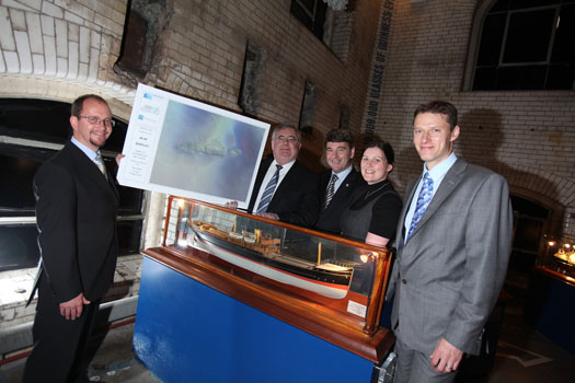
Koen Verbruggen (GSI), Minister Pat Rabbitte, Dr. Peter Heffernan (CEO, Marine Institute), Eibhlin Roche (Guinness Archivist, Guinness Storehouse) and David Smith (Country Director, Diageo Ireland) Photo: Jason Clarke Photography


Published in Marine Science

The Irish Cruising Club's acclaimed Sailing Directions, in two volumes, offer comprehensive coverage of the entire coast of Ireland, and their price has recently been reduced by £10.00 to £27.50 each (€32.50).
These are the only cruising guides for the Irish coast to be frequently and comprehensively updated, with corrections available free at www.irishcruisingclub.com.
The 310 page South and West volume was reviewed in Cruising magazine, Sept 2010: "If you are intending to cruise these coasts, or even if you are only thinking of doing so, it is essential. As Sailing Directions they are well-nigh perfect."
Written, edited, designed and printed on the island of Ireland, these handsome hardback books are carried as an aid to navigation and pilotage by the Irish Naval Service, the Irish Coast Guard and the Commissioners of Irish Lights, and they are used as a reference source by the UK Hydrographic Office.

ICC_both_SDs

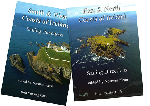
ICC SDs are available from chandlers and booksellers, and are distributed in Great Britain and the rest of the world by Imray, and in Ireland by Todd Chart Services. East and North Coasts Directions ISBN 978 0 9558 199 1 9; South and West Coasts Directions ISBN 978 0 9558 199 2 6.

Published in Cruising

About Dublin Port 

Dublin Port is Ireland’s largest and busiest port with approximately 17,000 vessel movements per year. As well as being the country’s largest port, Dublin Port has the highest rate of growth and, in the seven years to 2019, total cargo volumes grew by 36.1%.

The vision of Dublin Port Company is to have the required capacity to service the needs of its customers and the wider economy safely, efficiently and sustainably. Dublin Port will integrate with the City by enhancing the natural and built environments. The Port is being developed in line with Masterplan 2040.

Dublin Port Company is currently investing about €277 million on its Alexandra Basin Redevelopment (ABR), which is due to be complete by 2021. The redevelopment will improve the port's capacity for large ships by deepening and lengthening 3km of its 7km of berths. The ABR is part of a €1bn capital programme up to 2028, which will also include initial work on the Dublin Port’s MP2 Project - a major capital development project proposal for works within the existing port lands in the northeastern part of the port.

Dublin Port has also recently secured planning approval for the development of the next phase of its inland port near Dublin Airport. The latest stage of the inland port will include a site with the capacity to store more than 2,000 shipping containers and infrastructures such as an ESB substation, an office building and gantry crane.

Dublin Port Company recently submitted a planning application for a €320 million project that aims to provide significant additional capacity at the facility within the port in order to cope with increases in trade up to 2040. The scheme will see a new roll-on/roll-off jetty built to handle ferries of up to 240 metres in length, as well as the redevelopment of an oil berth into a deep-water container berth.

Dublin Port FAQ

Dublin was little more than a monastic settlement until the Norse invasion in the 8th and 9th centuries when they selected the Liffey Estuary as their point of entry to the country as it provided relatively easy access to the central plains of Ireland. Trading with England and Europe followed which required port facilities, so the development of Dublin Port is inextricably linked to the development of Dublin City, so it is fair to say the origins of the Port go back over one thousand years. As a result, the modern organisation Dublin Port has a long and remarkable history, dating back over 300 years from 1707.

The original Port of Dublin was situated upriver, a few miles from its current location near the modern Civic Offices at Wood Quay and close to Christchurch Cathedral. The Port remained close to that area until the new Custom House opened in the 1790s. In medieval times Dublin shipped cattle hides to Britain and the continent, and the returning ships carried wine, pottery and other goods.

510 acres. The modern Dublin Port is located either side of the River Liffey, out to its mouth. On the north side of the river, the central part (205 hectares or 510 acres) of the Port lies at the end of East Wall and North Wall, from Alexandra Quay.

Dublin Port Company is a State-owned commercial company responsible for operating and developing Dublin Port.

Dublin Port Company is a self-financing, and profitable private limited company wholly-owned by the State, whose business is to manage Dublin Port, Ireland's premier Port. Established as a corporate entity in 1997, Dublin Port Company is responsible for the management, control, operation and development of the Port.

Captain William Bligh (of Mutiny of the Bounty fame) was a visitor to Dublin in 1800, and his visit to the capital had a lasting effect on the Port. Bligh's study of the currents in Dublin Bay provided the basis for the construction of the North Wall. This undertaking led to the growth of Bull Island to its present size.

Yes. Dublin Port is the largest freight and passenger port in Ireland. It handles almost 50% of all trade in the Republic of Ireland.

All cargo handling activities being carried out by private sector companies operating in intensely competitive markets within the Port. Dublin Port Company provides world-class facilities, services, accommodation and lands in the harbour for ships, goods and passengers.

Eamonn O'Reilly is the Dublin Port Chief Executive.

Capt. Michael McKenna is the Dublin Port Harbour Master

In 2019, 1,949,229 people came through the Port.

In 2019, there were 158 cruise liner visits.

In 2019, 9.4 million gross tonnes of exports were handled by Dublin Port.

In 2019, there were 7,898 ship arrivals.

In 2019, there was a gross tonnage of 38.1 million.

In 2019, there were 559,506 tourist vehicles.

There were 98,897 lorries in 2019

Boats can navigate the River Liffey into Dublin by using the navigational guidelines. Find the guidelines on this page here.

VHF channel 12. Commercial vessels using Dublin Port or Dun Laoghaire Port typically have a qualified pilot or certified master with proven local knowledge on board. They "listen out" on VHF channel 12 when in Dublin Port's jurisdiction.

A Dublin Bay webcam showing the south of the Bay at Dun Laoghaire and a distant view of Dublin Port Shipping is here
Dublin Port is creating a distributed museum on its lands in Dublin City.
 A Liffey Tolka Project cycle and pedestrian way is the key to link the elements of this distributed museum together.  The distributed museum starts at the Diving Bell and, over the course of 6.3km, will give Dubliners a real sense of the City, the Port and the Bay.  For visitors, it will be a unique eye-opening stroll and vista through and alongside one of Europe’s busiest ports:  Diving Bell along Sir John Rogerson’s Quay over the Samuel Beckett Bridge, past the Scherzer Bridge and down the North Wall Quay campshire to Berth 18 - 1.2 km.   Liffey Tolka Project - Tree-lined pedestrian and cycle route between the River Liffey and the Tolka Estuary - 1.4 km with a 300-metre spur along Alexandra Road to The Pumphouse (to be completed by Q1 2021) and another 200 metres to The Flour Mill.   Tolka Estuary Greenway - Construction of Phase 1 (1.9 km) starts in December 2020 and will be completed by Spring 2022.  Phase 2 (1.3 km) will be delivered within the following five years.  The Pumphouse is a heritage zone being created as part of the Alexandra Basin Redevelopment Project.  The first phase of 1.6 acres will be completed in early 2021 and will include historical port equipment and buildings and a large open space for exhibitions and performances.  It will be expanded in a subsequent phase to incorporate the Victorian Graving Dock No. 1 which will be excavated and revealed. 
 The largest component of the distributed museum will be The Flour Mill.  This involves the redevelopment of the former Odlums Flour Mill on Alexandra Road based on a masterplan completed by Grafton Architects to provide a mix of port operational uses, a National Maritime Archive, two 300 seat performance venues, working and studio spaces for artists and exhibition spaces.   The Flour Mill will be developed in stages over the remaining twenty years of Masterplan 2040 alongside major port infrastructure projects.

Source: Dublin Port Company ©Afloat 2020.