Displaying items by tag: Irish
Waterford Harbour (Dunmore East) Sailing Club
Waterford Harbour (Dunmore East) Sailing Club
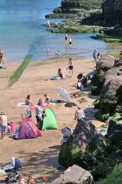 Founded in 1934 this is a family club with around 200 members. The clubhouse was extensively renovated in 2004. Visitors are most welcome and a limited number of visitor berths are available. Showers and toilets are also available to visitors in the summer. The clubhouse, with bar and snack meals, is open daily in the summer and at weekends during the winter. ISA Junior training courses and powerboat courses take place from late June until mid-August. Yachtmaster Coastal and Offshore shorebased courses are available during the winter.
Left: The beach at Dunmore East
COURSES OFFERED – Dinghy: Up to Improving Skills, Advanced Boat Handling, Racing 1, Kites & Wires 1, Adventure 1. Power Boat: 1, 2 and Safety Boat. Cruising Shorebased: Yachtmaster Coastal and Offshore
Waterford Harbour (Dunmore East) Sailing Club, c/o Derry O'Sullivan, The Harbour, Dunmore East, Co Waterford. Tel: 051 383389 and 383230, email: [email protected]
Have we got your club details? Click here to get involved
Swords Sailing and Boating Club
Swords Sailing & Boating Club
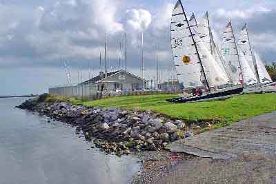 Located Halfway between Malahide and Swords, near the main Belfast road. Season runs from March to December. Very active dinghy programme – and a very active club for both the young and the young at heart!
We have grown from humble beginnings, operating from a cargo container, to become a well established club boasting four national champions in different fleets in the one year!!
Racing every Sunday at 2pm and Wednesdays at 7.30. Friendly family Orientated club. New members always welcome.
Swords Sailing & Boating Club, c/o Donal Brennan, Broadmeadow Estuary, Swords, Co Dublin. Tel: 01 8454 686, email: [email protected]
Have we got your club details? Click here to get involved
Donegal Bay Rib Club Ltd
Donegal Bay Rib Club Ltd
Donegal Bay Rib Club Ltd was founded in 2008. It is a non-profit making organisation and a company limited by guarantee registered at Companies Office, Dublin.
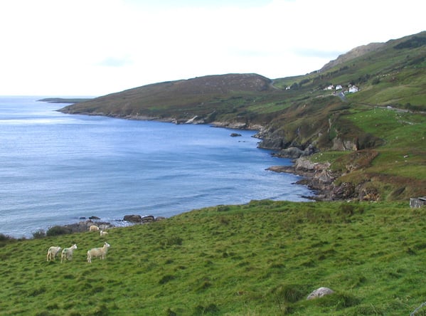
The Club comprises a group of RIB (Rigid Inflatable Boat) enthusiasts and boat owners from the Donegal Bay area. At present it has a membership of aproximately 50 persons and is very much family orientated.
The Club is affiliated to the ISA (Irish Sailing Association) and operates mainly from Creevy Pier and Ballyshannon, Co Donegal with weekly boat trips to places such as Mullaghmore, Innis Murray Island, Inniscrone, Killybegs, Inver, Slieve League, Arranmore Island, Burtonport and so on. In 2008 our annual Rib Raid took us to Islay in Scotland and this year we went to the Isle of Man. The 2009 'expedition' saw two baots with 10 crew travel to Fort William, Scotland, a round trip of about 220 miles.
If you would like to join us please contact the club secretary on 087 2313 098 or [email protected] This email address is being protected from spambots. You need JavaScript enabled to view it.
Donegal Bay Rib Club Ltd – contact Niall Quinn, Club Secretary: 087 2313 098, or Andrew Fenton, Special Operations: 087 262 3397
Drop an email to the club secretary for all queries.
Drogheda Port
Drogheda Port
Drogheda Port is one of Ireland’s premier multi modal ports strategically located on the east coast with direct motorway access to the country’s key industrial and commercial centres. The port is continuing to develop and expand by offering its customers a strategic locational advantage in an increasingly competitive marketplace.
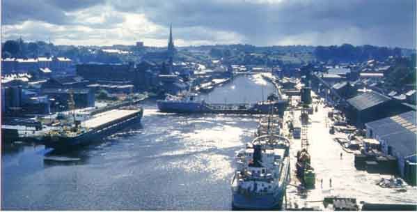
We have built a solid reputation on our high levels of customer service, flexibility, and the rapid turnaround of vessels. Few ports boast such a prime position for taking advantage of the ever increasing opportunities in European and Scandinavian trades, in addition to the emerging markets of Eastern Europe and the ever changing patterns of short sea container trade.
Drogheda Port has established itself as Ireland's gateway to Scandinavia with the country’s only weekly service to Norway, Sweden and Denmark. The port is also Irelands major distribution and logistics centre for newsprint.
Drogheda Port Company is a highly successful commercial state port which handles over 1.4 million tonnes of cargo annually in addition to over 700 vessel calls. Throughput for 2005 totalled 1,401,555 million tonnes.
The Company provides port facilities for both general freight and container services, and has a record of continuous growth in both.
The Port has a wide product base and a balance of trade at approximately 75% import and 25% export. We are a natural choice for a wide range of customers and trades, with facilities to handle virtually any type of cargo.
Imports include Containers, Paper, Steel, Timber, Fertilizer, Grains, Petroleum and Liquefied Petroleum Gas. Exports include Containers, Magnesite, Zinc Concentrate and Timber.
Geographically, the Port is situated on the historic River Boyne on Ireland's east coast with direct access to both Dublin and Belfast on the M1 Motorway. The port's position on the east coast of Ireland provides a major geographical advantage for transport links in to and out of Ireland. As a result, the port has very strong short-sea trade links with Europe, Scandinavia and the Baltic states. Regular and frequent general cargo and container services to Norway, Sweden and Denmark have established Drogheda Port as Ireland's Gateway to Scandinavia.
The Port has built its reputation on high levels of customer service, flexibility and the rapid turnaround of vessels. A container service operates from Tom Roes Point Terminal and presently provides a twice weekly service between Drogheda and Rotterdam.
Facilities
The Drogheda Port Company has two facilities for the loading/discharging of cargoes, i.e. the inner north quays port and the deep-water facility at Tom Roes Point Terminal. In addition there are two private facilities. The approach and estuarial channel is maintained to a depth of 2.2m at Chart Datum to the deep water facility at Tom Roes Point, 5 km from the sea, and at 0.8m at Chart Datum to the inner port 7 km from the sea. The port can currently accommodate vessels up to 120m LOA.
The deep-water facility at Tom Roes Point is the primary container/paper and timber handling facility. The berth is 160m in length with an always-afloat dredged pocket of 6m at Chart Datum over a length of 210m. The berth can accommodate single vessels operations up to 120m LOA or two vessel of 100m LOA. There are on site open storage facilities of circa 14 acres and a paper store of 90,000sq ft. Primary handling is by two Liebherr LHM 250 harbour mobile cranes with additional tracked grabbing cranes. Secondary handling is by a modern fleet of dedicated container handling and general purpose forklifts. The inner north quay port is a general cargo facility catering for bulk grains, steel, timber etc. The 4 berths consist 430m of quay. Three of the berths have an air draft restriction of 27.5m at MHWS. Primary cargo handling is by a combination of harbour mobile and crawler cranes with appropriate secondary handling.
A private hydrocarbons facility can accommodate vessel of up to 80m LOA, in a dredged pocket of 2.2m at Chart Datum. The oil terminal has a current capacity of 10,000m3 of Class 1, 2 and 3 products, plus, 1,500m3 capacity at the LPG terminal. A private bulk cement/magnesite/coal facility can accommodate two vessels on a 160m berth.
A Brief History of the Port
We can never be certain as to when man first sailed up the River Boyne, but we do know it would have looked a very different place then. The evidence points us to a date around 3,000 B.C. when middle Stone Age man arrived. They sailed their boats into the mouth of the river and progressed as far as Newgrange. The landscape at the time would have been heavily wooded and the Boyne itself much wider and slower moving.
Drogheda provided a natural ford on the river at the current site of St. Mary’s Bridge from where the first houses and quays were built. From that era to the current day the port has progressed into an important commercial highway trading with Europe, Scandinavia, Asia and America.
It is said that Saint Patrick landed at Colpe in 432 AD and in 937 AD it is recorded that there were 60 Viking ships on the Boyne and 60 on the Liffey as they plundered the ancient sites of Ireland. The vikings returned to the Boyne on many occasions and used the port as a base for their plundering expeditions.
In the 1400’s goods were coming from all over Europe to Drogheda Port. Archaeological excavations over the years show Drogheda to have been a very cosmopolitan town due to the ports trading links with the outside world. Pottery from Bordeaux, Gascony and Flanders have been found.
Wine from France was a very important trade at this time with up to two to three ships per week fully laden. Goods such as hides and corn form the local region were exported to places like Gdansk, Lisbon and Iceland.
Moving on through the 16th Century Drogheda had developed a good trading relationship with Liverpool exporting mostly linen and flax. This relationship further developed in the 1800’s when Drogheda had a regular passenger steamer service to Liverpool. The steamers would sail initially 2/3 times a week and were the first in the world to have electric light on board. The service further expanded some years later to become a daily service and include Glasgow on the route.
The journey to Liverpool then took over 14 hours and could be very hazardous and uncomfortable, where today it would just take over 3 hours on the new generation high-speed ferries. The ships carried a mixture of cattle and passengers, and sometimes the cattle were better treated. The first steamer in 1826 was called the 'Town of Drogheda', and many others followed.
Many ships were also build in the port and Grendons foundry which was established in 1835 employed up to 600 people and produced many steel ships which were launched on the Boyne.
In the 19th century Drogheda became one of the ports through which thousands of Irish people emigrated from famine and out to the new world.
The most striking visual feature in the Port is the Viaduct which was build in 1855 for a total cost of only £124,000 and is still as solid and functional today as the day it was built.
Work on the quays in the old days was hard and dirty with cargoes such as coal having to be shovelled out of the ships hold by hand. It took many dozens of men to do this work on each ship. Today there is a different picture with technology and mechanisation, loading and unloading large amounts of cargo from ships has become much quicker.
Ships today are better designed and have more technology allowing them to predict and manage bad weather and as a result a have much safer passage.
The management of the port began a new era in 1997 when the Drogheda Harbour Commissioners were dissolved after over 200 years and the port became a new commercial semi-state company, Drogheda Port Company.
A new deepwater terminal has been constructed at Tom Roes Point which will be capable of handling larger vessels than the inner port was capable of. Vessels carrying up to 5,000 tonnes of cargo and up to 120 metres in length will use the new facility. New short sea shipping routes have developed from the terminal particularly in unitised trade. As ships have been getting larger there has been a slow progression for the port seaward. Up to the 1800’s ships were unloaded as far up the river as St Mary’s bridge. The main working quays gradually moved to the Ballast, Welshmans and Steampacket quays and now new berths are operating at Tom Roes Point Terminal.
Drogheda Port has always been an integral part of the town economy and played a major role in its outward looking nature. The industrial base of the town was established through the port and it will continue to be a vital element in the town’s future growth.
Drogheda Port, Harbourville, Mornington Road, Drogheda, Co Meath
Sat Nav Co-Ordinates N 53.43.148 W 6.18.468
Telephone – Ireland: 041 983 8378 • International: +353 41 983 8378
Fax – Ireland: 041 983 2844 • International: + 353 41 983 2844
Email – General: [email protected]
Port of Ballina
Port of Ballina
Coordinates: 54°07′00″N 9°10′00″W / 54.1167°N 9.1667°W / 54.1167; -9.1667
Ballina (Irish: Béal an Átha or Béal Átha an Fheadha, lit. mouth of the ford) is a large town in north Co Mayo in Ireland. It lies at the mouth of the River Moy near Killala Bay, in the Moy valley and Parish of Kilmoremoy, with the Ox Mountain range to the east and the Nephin Beg mountains to the west. The town occupies two Baronies; Tirawley on the west bank of the Moy River, and Tireragh on the east bank.
The recorded population of Ballina's urban area is 10,409. Census 2006 figures released by the Central Statistics Office in September 2007 showed that Ballina had the highest rate of unemployment amongst large towns in the Republic of Ireland. Some 15.8% of Ballina's population was out of work when the 2006 census was taken. Unlike neighbouring towns such as Castlebar and Sligo, it is claimed that Ballina suffered from a lack of government investment for many years because it was not effectively represented in Dail Eireann.
According to Encyclopaedia Britannica the first signs of settlement on the site of the town dates from around 1375 when an Augustinian friary was founded. Belleek, now part of the town, pre-dates the town’s formation, and can be dated back to the late 15th century, or early 16th century. However, what is now known as Belleek Castle was built in 1831. Ballina was officially established as a town in 1723 by O'Hara, Lord Tyrawley.
Belleek Estate
The Belleek estate once occupied lands from the Moy River to the modern-day Killala Road. This included part of the ‘Old French Road’ which General Humbert marched on from Killala, and beside part of which in the Killala Road-Belleek area was Belleek’s reservoir – presumably destroyed in the construction of Coca-Cola’s ‘Ballina Beverages’ factory; the ‘Old French Road’ is now closed off at that point, with what amounts to diversion road signs claiming Humbert marched where he did not.
Old Borders
Ballina is located on the west side of the County Mayo - County Sligo border. Part of what is now the town was once (prior to the Local Government Act, 1898) part of County Sligo, with the border for the most part once being the River Moy, east of which was in Sligo, including Ardnare], and Crockets Town (the Quay).
Port of Ballina, River Moy Harbour Commission, The Quay, Ballina, Co. Mayo. Tel: 096 21208.
Port of Arklow
Port of Arklow
(Courtesy of WikiPedia , the free encyclopedia)
Arklow (In Irish: An tInbhear Mór, meaning 'The great estuary'), also known as Inbhear Dé from the Avonmore river''s older name Abhainn Dé, is a historic town located in Co. Wicklow on the east coast of Ireland. Founded by the Vikings in the ninth century, Arklow was the site of one of the bloodiest battles of the 1798 rebellion. It is now a thriving commuter town with a population of 11,759 at the 2006 census, making it the third largest town in the county.
Arklow is situated at the mouth of the River Avoca (formerly Avonmore), the longest river entirely within Co. Wicklow. The town is divided by the river, which is crossed by the Nineteen Arches bridge, a stone arch bridge linking the south or main part of the town with the north part, called Ferrybank. The Nineteen Arches bridge is the longest hand made stone bridge in Ireland and is considered a famous landmark. The plaque which is situated on the south end of the bridge is testimony to this.
The town's English name derives from Arnkell's Lág (Arnkell was a Viking leader; a 'lág' (low) was an area of land). Its Irish name means the large estuary. Historically it was a major seafaring town, with both the shipping and fishing industries using the port, with shipbuilding also being a major industry. The town has a long history of industry, in particular the chemical industry.
After the arrival of the Anglo-Normans, their leader Theobald Wawlter, ancestor of the Earls of Ormonde, was granted the town and castle of Arklow by King Henry II. In 1264 the Dominicans were granted a large tract of land, which is now known as Abbeylands, and they built an abbey, which became known as the Priory of the True Cross or Holy Cross.
Some time after 1416, the Manor of Arklow came into the control of the MacMurrough Kings of Leinster, possibly after the death of the 4th Earl of Ormonde in 1452. In 1525, Muiris Kavanagh (McMurrough, King of Leinster 1522–31) returned the manor and castle of Arklow and its lands to his nephew Piers Butler, the Earl of Ormonde.
During the Wars of the Three Kingdoms in September 1649, Oliver Cromwell arrived at Arklow on his way to Wexford and took the surrender of the town. In 1714 James, Duke of Ormonde, sold the Manor of Arklow to John Allen of Stillorgan, County Dublin. In 1750 Allen’s eldest granddaughter Elizabeth Allen married John Proby who was raised to the peerage in 1752 as Baron Carysford of Co Wicklow, and came into possession of the Arklow Estate.
On June 9 1798, the town was the scene of one of the bloodiest battles of the 1798 rebellion when a large force of Wexford rebels attacked the town in an attempt to spread the rising to Dublin but were repulsed by the entrenched British forces with huge slaughter.
Arklow's proximity to Dublin and its consequent attractiveness to commuters have led to much recent expansion. The town is situated near the N11 route from Rosslare to Dublin, as well as having rail connections provided by Iarnrod Eireann along the same route, including commuter services in and out of the capital. There is also a connection available to and from Waterford Monday to Friday. Arklow railway station opened on 16 November 1863.
Arklow is served by three Bus Eireann routes. These consist of the 002 service which operates between Dublin Airport and Rosslare Harbour, day and night, the 006 service which links Dublin, Arklow,New Ross and Waterford, and the 133 service, which operates between Arklow and Wicklow via Avoca. In addition, Wexford Bus operates several services day and night linking Arklow with Dublin Airport, the bus stop for which is located on the old Dublin road just off the bypass junction at the north end of the town.
Arklow Port Authority, Harbour Office, South Quay, Arklow, Co. Wicklow. Tel: 0402 32466, fax: 0402 30168
Clifden Boat Club
Clifden Boat Club
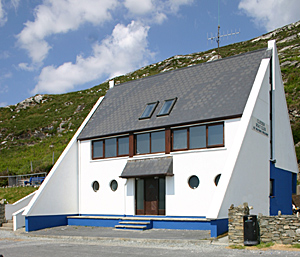
The Clifden Boat Club is a small sailing Club situated on the west coast of Ireland, just two miles outside the picturesque town of Clifden, Connemara. The committee and members of the club have been working hard to provide fantastic yacht racing and also some great sail training.
The team at Clifden Boat Club, having hosted the West Coast Championships for 2007 and 2008, are looking forward to another exciting and rewarding sailing season in 2009.
The Club is situated at the eastern end of the very sheltered Clifden bay providing great anchorage and easy access to a slip. Clifden harbour is 1km farther east providing a very safe and sheltered tidal harbour with a draft of about 3m at mean high water. The clubhouse itself is close to the Clifden Bay anchorage and has shower/changing rooms a bar and restaurant. Services Available include Visitors Moorings and safe anchorage.
The following is always
available:
Fresh water 25m from slip
Fuel and Lube oil
available in drums from Clifden town and tanker deliveries to Clifden
quay.
All stores available in Clifden town (2km from clubhouse, 1km from
Clifden quay)
Some spares and mechanical repair available
There is an internet Cafe in Clifden. The Boat Club is available for meetings and conferences by arangement. The First port of call for visitors should be the Clifden Boat Club where facilities are available and where information can be obtained.
Committee Details 2009/2010
Commodore – Bobbi O'Regan 0879870371 [email protected]
Secretary – Damian Ward 0872418569 [email protected]
Treasurer – Bobbi O'Regan 0879870371 [email protected]
Assist. Treasurer - Jackie Ward 09521898
Membership Sec – Donal O'Scannaill 0861665278
Liaison Officer/PRO – Damian Ward
Development Officer – Jackie Ward
Safety Officer – Werner Cook 0876427167
Race Officer/Sailing Sec – Paul Ryan 0862931819
Winterising Your Boat
Winterising Your Boat
The whole idea of winterisation can be about as appealing as having a tooth filled – and possibly as expensive – but there’s no substitute for being prepared, and a reluctance to cough up the necessary budget can be a false economy in the long run.
Of course, winterisation is not a word that will stir much enthusiasm in the breast of the average boat-owner, bringing home the fact that summer is over and the evenings will now close in with unprecedented speed.
However, the W-word could be quite painless, even fun, if you are into that sort of thing. And most sailors love their boats – it being a source of pride and pleasure – and want to keep them in top condition.
This Afloat guide to winterising your boat (see menu on right hand side of page) will steer you towards those who can do the job for you, or at least give you useful advice so that you don’t end up standing in the dark, cold, wet, and frustrated, with oil on your clothes and an engine strewn all over the driveway.
It may be true that in the depths of winter lies an invincible summer.
South Meath Jet Ski Club
South Meath Jet Ski Club
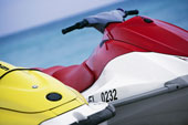
The South Meath Jet Ski Club was originally formed by a group of PWC and Powerboat enthusiasts from the village of Longwood in south county Meath. The Club's goal is primarily to protect the sport that our members have enjoyed for many years. The club was affiliated to the ISA in December 2008 and an active working relationship is now in place. To date we have held a number of events, which you can read about on our website. We are looking forward to working with, and enjoying the water, with all our new friends in the PWC community. Please do contact us if you would like to know more.
South Meath Jet Ski Club c/o Declan Swan, St Olivers, Longwood, Co Meath. Tel: 086 821 9753, mail: [email protected]
Have we got your club details? Click here to get involved
South Coast Garda Sailing Club
South Coast Garda Sailing Club
The Garda Siochana (Irish Police Force), Sailing Club was formed in October 1993 to promote sailing and all its benefits among members of the Force.
The Force now has two clubs – one on the South Coast and another on the East Coast, based in Dublin.
Membership of SCGSC is open to Garda and non-Garda members. If you would like to learn more about what we do please contact us.
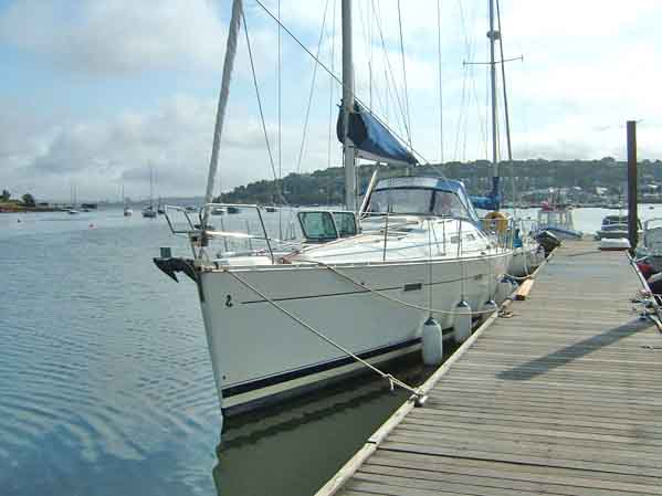
SCGSC is the proud owner s of Explorer, a Beneteau 393, pictured above. SCGSC has previously owned a Westerly Konsort and a Jeanneau SunFizz.
The 2005 cruising programme included a number of cruises on the South West Coast and two aborted cruises to the Isles of Scilly off Cornwall. Even the foolhardy occasionally stay in port in bad weather.
In the racing front the club has competed in the Round Ireland and Cork Week races. Already in 2005 the club claims a 3rd place in the Cobh Regatta and third overall in the Cobh Sailing Club September League. We also achieved a notable 6th place in the Royal Cork Yacht Club Autumn League White Fleet. Well done everybody concerned.
In racing in 2006 the Club placed 3rd in White Fleet in the annual Blackrock Race, we have also competed in several of the Leagues hosted by Cobh Sailing Club during the summer with notable results.
We would welcome contact from other police force sailing clubs internationally.
Cruise bookings: [email protected]
(The above information and image courtesy of the South Coast Garda Sailing Club)
South Coast Garda Sailing Club, c/o Patrick Allen, Anglesea Street Garda Station, Cork. Tel: 087 278 6794, email: [email protected]
Have we got your club details? Click here to get involved


