


Displaying items by tag: MCZ
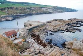
#MarineWildlife - Islandmagee locals are appealing to Northern Ireland's Environment Minister to add their waters to the list of recently proposed Marine Conservation Zones.
As the Belfast Telegraph reports, the call comes over fears that a planned Gaelectric gas power station could create a 'dead zone' in the North Channel caused by brine runoff from the plant.
Gaeletric maintains that even under a worst-case scenario, any impact of brine pumped into the sea on marine wildlife and plantlife would be low.
But the Islandmagee Community Residents Association argues that the development poses a threat to a "delicate and biodiverse" ecosystem in the area, which is home to vulnerable colonies of puffins as well as black guillemots and razorbills, among others.
As reported in December on Afloat.ie, Rathlin, Waterfoot, Outer Belfast Lough and Carlingford Lough were put forward for consideration as Marine Conservation Zones, the public consultation for which closed last Friday 11 March.
The Belfast Telegraph has more on the story HERE.

#MarineWildlife - New marine protections for Northern Ireland's waters could provide a further sanctuary for our smallest marine mammal, the harbour porpoise.
As the Belfast Telegraph reports, the proposed Marine Conservation Zone (MCZ) for the area between Belfast Lough and Carlingford Lough would join the Causeway Coast zone protected in 2012.
The news comes some months after the European Commission put pressure on Westminster to designate more protected areas for the smallest of Ireland's cetaceans, whose swimming grounds are being encroached by offshore wind farm development.
And the new proposals for Northern Irish waters also include protections for important seabird colonies as well as an area of seagrass that's vital to local biodiversity.
But the overall scale of the UK's MCZ plans, reduced from more than 100 proposed zones to a total of 50 over the past two years, has been criticised by conservation groups for betraying a 'lack of ambition'.
The Belfast Telegraph has more on the story HERE.
UK Designates New Marine Conservation Zones

#MarineWildlife - The British government has announced the creation of 27 new marine conservation zones (MCZs) after a long delay, as BBC News reports.
Last December it was decided that just 31 of the 127 potential sites for marine wildlife protection around the British coastline proposed by government advisors would be designated as MCZs - a decision welcomed by some coastal users but lambasted by conservation groups as displaying a "lack of ambition".
More recently, professional fishery managers expressed their disappointment with the reduction in scale - since reduced further by increased costs at four sites - and called for a "clear timetable" for expansion of the zones network.
Plans were delayed further earlier this year, with the situation blamed by Environment Minister Richard Beynon on budget cuts and the high cost of scientific assessment.
The news that 27 MCZs are now finally designated has been welcomed as a "significant milestone" by the Marine Conservation Society, which still warns that it falls short of the proposals recommended for an "ecologically coherent" network.
BBC News has much more on the story HERE.
#MarineWildlife - UK environmentalists have expressed their disappointment at the British government's slow progress on developing its promised network of Marine Conservation Zones (MCZs), as the Belfast Telegraph reports.
The consultation period was for the proposals was set to end on Sunday 31 March - amid fears among conservation groups that were realised some months ago with the news that just 31 out of a potential 127 sites would be designated as protected for marine wildlife and plantlife by the end of this year.
It's being reported that Environment Minister Richard Beynon is blaming budget cuts and the high cost of scientific assessment for the slowdown in progress on the government's side.
"I want to do as many zones as we can for as little as we can," he told the BBC. "People have waited many years for this; we will designate the first tranche in September and will announce the next lot for consultation then."
The Royal Yachting Association (RYA) said in December that it was "encouraged" by the British government's "sensible" phased approach to the MCZ plans.
However, conservationists like Jolyon Chesworth from the Wildlife Trusts argue that their interests are being asked "to compromise on a compromise".
Chesworth added that the original 127 zones "were only nominated after very long discussions with anglers, sailors and the fishing industry".
The Belfast Telegraph has more on the story HERE.
Proposed Irish Sea Conservation Zones
The area include the inshore waters of Merseyside, Lancashire and Cumbria and offshore waters of the Isle of Man, Wales, Northern Ireland and England. One of the zones is a 187 square km stretch of deep water between Northern Ireland and the Isle of Man.
In order to gain a greater understanding of the proposed zones, the report commissioned a Regional Stakeholder Group which drew from a diverse range of interests in the Irish Sea. Among the stakeholders included were the Royal Yachting Association, the fishing community and ports authorities. The review identified the size, shape and locations of the proposed 10 ten new Marine Conservation Zones. For the first time, the zones included inshore water of the Irish Sea project area as well as offshore.
"This is a real milestone for the project, with potential Marine Conservation Zones identified in both inshore and offshore waters", said Greg Whitfield, project manager at Irish Sea Conservation Zones.
"It is now really important that people take a look at the potential zones and give us their feedback on them. The better the information we have, the better the Marine Conservation Zones that are recommended by the regional stakeholder group will be."
Each of the marine conservation zones are designed to protect nationally important marine wildlife, habitats and geology. In addition they are designed to have the least impact possible on people's activities, but some restrictions will apply as the zones must meet guidelines for protecting species and habitats.
Members of the public are being invited to participate and will be considered as the second project continues to refine its proposals. The report is only a snapshot of the work so far. It does not contain concrete recommendations for the locations of Marine Conservation Zones (MCZ) in the Irish Sea, and the potential zones shown in the report are described as tentative and liable to change.
The Irish Sea Conservation Zone project will be releasing a third report before the Regional Stakeholder Group finalises its recommendations. The reports are delivered to the Science Advisory Panel. The independent body is comprised of expert scientists whose main role is to evaluate the potential of MCZs against ecological criteria.
The third progress report will be made available in February 2011. Its final recommendations will then be presented to the UK government in June. Following that a formal public consultation on the proposed MCZs are to take place in late 2011 and early 2012.
For information on the Second Progress Report including feedback forms can be downloaded from HERE or by calling 00 44 (0)1925 813 200


 linking Spain.")


 Michael Murphy Schull Harbour Sailing Club (SHSC), Eric Coogan Heineken Ireland, Mark Murphy, Commodore SHSC, Jack Allen SHSC, Carmel O'Regan SHSC, Cornelious Ndlovu, Schull Harbour Hotel Operations Manager and Derval Murphy SHSC")


