


Displaying items by tag: Marine Notice
Marine Notice: Cable Recovery Off South West Coast
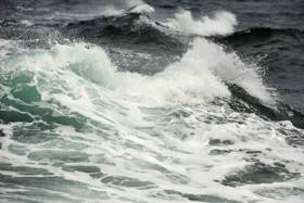
#MarineNotice - The latest Marine Notice from the Department of Transport, Tourism and Sport (DTTAS) advises that that a cable recovery operation is scheduled take place from next Monday 9 to Wednesday 25 October at locations off the South West Coast.
The work will be carried out by the MV Layla (Callsign V2YX9). Please note that this vessel is restricted in her manoeuvrability and mariners are advised to navigate with caution in the area.
Radio and Pan-Pan alerts will be issued periodically and the MV Layla will be on standby on VHF Channel 16 at all times.
In total, 88km of cable is planned to be recovered. Full details of the operation are included in Marine Notice No 42 of 2017, a PDF of which is available to read or download HERE.
Marine Notice: Nearshore Survey Operations For ‘Celtic Interconnector’ Project
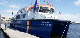
#MarineNotice - RMS Submarine Ltd advises that they will be conducting nearshore survey operations associated with the proposed Celtic Interconnector on behalf of EirGrid, at three coastal locations in Co Cork — namely Ballinwilling Strand, Redbarn Beach and Claycastle Beach.
The survey vessel Severn Guardian (Callsign 2FGL5), an 18m catamaran coastal survey vessel, will operate on a 12-hour daily basis, in daylight hours only, commencing from today (Thursday 28 September) for the next two weeks, approximately. Common frequency VHF Channel 16 shall be used throughout the project.
This survey is to collect geophysical data utilising vessel mounted sensors and a towed sonar which will extend up to 100m from the vessel. The survey will be conducted under Foreshore Licence FS006722, as per the foreshore licence map included in Marine Notice No 41 of 2017.
The nearshore survey activities will extend no more than 5km from the shoreline, within a 1km area or corridor centred at each of the three coastal locations. The remaining offshore sections will be surveyed by a separate vessel in the coming months, for which a separate notice to mariners will be issued.
Full details of co-ordinates of the work areas and more are included in Marine Notice No 41 of 2017, a PDF of which is available to read or download HERE.
Groundfish Survey Off North West Coast This October
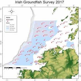
#MarineNotice - The Marine Institute advises that the annual Irish Groundfish Survey (IGFS2017) will be carried out off the North West Coast of Ireland between Tuesday 3 and Saturday 14 October, in fulfilment of Ireland’s Common Fisheries Policy obligations.
The IGFS is a demersal trawl survey consisting of approximately 45 fishing hauls of 30 minutes duration each in ICES area VIa. Fishing in 2017 will take place within a two nautical mile radius of these 45 positions, the approximate locations of which are noted in Marine Notice No 39 of 2017.
The survey will be conducted by the RV Celtic Explorer (Callsign: EIGB), which will display all appropriate lights and signals during the survey and will also be listening on VHF Channel 16. The vessel will be towing a high headline GOV 36/47 demersal trawl during fishing operations.
This survey is to determine the relative annual abundance and distribution of commercially exploited fish stocks, in particular assessment of recent recruitment. In addition, other species of national importance are sampled along with physical and chemical oceanographic parameters.
The Marine Institute requests that commercial fishing and other marine operators keep a two nautical mile area around the tow points clear of any gear or apparatus during the survey period outlined above.
While there is no statutory provision for the loss of gear at sea, the Marine Institute will make every effort to avoid gear, adequately marked according to legislation, that may be encountered in the notified areas. In the event that an operator has static gear or other obstructions within 2nm of the trawl points, it is the responsibility of the owner to notify the survey managers or vessel directly.
This should be communicated by identifying specifically which ‘Prime Station’ is of concern using the appendix and contact details provided in Marine Notice No 39 of 2017, a PDF of which is available to read or download HERE.
It is not required to provide positional details of commercial operations beyond 3-4nm of the survey points provided. Specifics of any fishing gear or other obstructions that are known and cannot be kept clear of these survey haul locations can be notified using the contact details provided in the above Marine Notice.
Marine Notice: Diffuser Installation Off Bundoran From Monday
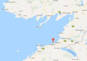
#MarineNotice - Marine works, including diving, will be carried out by Norfolk Marine to install a diffuser to the newly placed long sea outfall as part of the Donegal Group B Sewerage Scheme.
The works, which include the installation of a navigation aid to mark the outfall position, are expected to begin on Monday 25 September to last between one and two weeks.
The diffuser location will be west of Bundoran at Latitude 54° 28.778’ N and Longitude 08° 19.304’ W.
The diving and installation works will be carried out from the vessel Chateau Thierry (Callsign EI-HK-6). An additional small boat or RIB will also be involved in the operation as
required.
The vessel will display appropriate lights and markers, including the diving ‘Alpha Flag’ during diving operations. Vessel moorings will be marked with appropriate buoys. The vessel will monitor VHF Channel 16 throughout the works.
Further details are included in Marine Notice No 40 of 2017, a PDF of which is available to read or download HERE.
Marine Notice: Spiddal Wave Energy Test Site Decommissioning Works
#MarineNotice - The latest Marine Notice from the Department of Transport, Tourism and Sport (DTTAS) advises of the decommissioning of the wave energy test site in Galway Bay.
The decommissioning of the Marine Institute's wave energy site will involve the removal of four cardinal marks and a wave monitoring data buoy, and the establishment of a new special mark denoting the presence of the Galway Bay Subsea Observatory on the seabed at the site off Spiddal.
The Chateau Thierry (Callsign EIHK6) was scheduled to arrive in Galway Bay this week between Monday 11 and next Monday 18 September. This operation is expected to last two days, depending upon weather or other operational conditions.
It is anticipated that the decommissioning operation will be completed on or before Tuesday 19 September.
The Chateau Thierry will display appropriate lights and markers. The work vessel will be broadcasting and listening on VHF Channel 16 during the decommissioning.
Full details of co-ordinated of the relevant work areas are included in Marine Notice No 38 of 2017, a PDF of which is available to read or download HERE.
Call For Tenders For Radio Surveyors Panel
#MarineNotice - The latest Marine Notice from the Department of Transport, Tourism and Sport (DTTAS) advises that a panel of radio surveyors is being established for a period of three years from this October.
This panel will carry out statutory radio surveys on Irish seagoing vessels, including fishing vessels greater than 15m LOA, for compliance with the relevant statutory requirements.
Interested parties can access the tender information, and must submit their application, via the eTenders portal before 3pm on Friday 20 September.
Full details on the panel are included in Marine Notice No 36 of 2017, a PDF of which is available to read or download HERE.
Marine Notice: Air-To-Ground Shoot At Gormanstown Air Defence Range
#MarineNotice - The Defence Forces advise that they will conduct an Air Firing (Air to Ground) Shoot at Gormanston Ranges from Monday 28 August to Saturday 9 September, excluding Saturday 2 and Sunday 3 September, between 9am and 5.30pm each day.
The danger area (EID1) comprises the lands of Gormanston Aerodrome and the air and sea areas contained within a radius of three nautical miles centred on aerodrome.
This includes an additional area contained within a segment centred on Gormanston Aerodrome and bearing of 015º degrees true, through Mosney Railway Station and 106º degrees true, through Gormanston Railway Station seawards for a distance of 10 nautical miles.
For the periods while the range is active, the sea zone within the danger area is out of bounds to all vessels.
A Naval Service patrol vessel will enforce the exclusion zone ‘D1’ as indicated on UKHO Chart No 44.
All vessels are advised that they are required to remain outside of the exclusion zone whilst the range is active. Vessels are also recommended to carefully monitor the Radio Navigation Warnings that will be broadcast during the firing period.
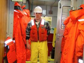
#WaterSafety - The latest Marine Notice from the Department of Transport, Tourism and Sport (DTTAS) advises everyone on or near the water of the correct use of lifejackets or personal flotation devices (PFDs).
Lifejackets should always be warn over all clothing, so that there is sufficient space for the device to inflate, the wearer’s breathing is not restricted, and there is easy access to activate a manual personal locator beacon.
Marine Notice No 34 of 2017 comes after the recent MCIB report into the death of lobsterman Patsy Kelly in Galway Bay last September, as previously reported on Afloat.ie.
Kelly, who went overboard from his vessel while retrieving a string of lobster pots, was found to be wearing a PFD but underneath an oilskin smock, significantly limiting his ability to signal for help.
The report also found that Kelly’s lifejacket was five months overdue for service of its active components, such as its gas canister and battery-operated light.
#MarineNotice - Piling and pontoon installation works were set to commence yesterday (Tuesday 8 August) at Killybegs Fishery Harbour Centre in Co Donegal.
The works, scheduled to be completed by Monday 16 October are being carried out by an 18m x 18m jack-up barge and a 22m x 10m spud barge, and involve use of heavy civil engineering drilling and lifting plant. Divers will also be employed.
For safety reasons, mariners are requested to stay clear of the jack-up barge and spud barge during these construction works, and are requested to proceed slowly and with caution in the area of the Black Rock Pier, Town Pier, slipway and the small craft harbour. Wave wash from vessels should be avoided. See Marine Notice No 33 of 2017 for more details.
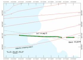
Elsewhere, Wind Cable Recovery is working on the recovery of two out-of-service communication cables (TAT 1 North Cable & TAT 1 South Cable) using vessels MV Layla (Callsign V2YX9) and the MV Lida (Callsign V2YF4).
The recovery of these cables in the Atlantic north-west of Ireland to be completed by 10 September 2017.
These vessels will be restricted in their ability to manoeuvre. All other vessels are requested to give this operation a wide berth.
The project vessel will be listening on VHF Channel 16 throughout the project. Further details are included in Marine Notice No 32 of 2017.
Marine Notice: Offshore Rock Placement In Corrib Gas Field
#MarineNotice - Shell E&P Ireland advises that it will commence rock placement works between two wells in the Corrib Gas Field before the end of this month.
These works, which are expected to be completed by the middle of August, come after a recent pipeline survey and inspection that included the installation of a replacement subsea control umbilical.
The latter requires the placements of rocks for protection within the 500m safety zone along the corridor between wells P1 and P5.
There will also be installation of rock protection/stabilisation at areas of known exposure or excess spanning along both the infield flow and control lines as well as the 20” pipeline and main control umbilical between the gas field and landfall at Glengad.
Works will be carried out by the DP Fall Pipe Rock Placement Vessel Seahorse (Callsign PCAP), which will be listening on VHF Channel 16 throughout.
Full co-ordinates of the rock placements are detailed in Marine Notice No 31 of 2017, a PDF of which is available to read or download HERE.


, Geraldine (white) and Estelle (yellow), on their new moorings off the bandstand at Dun Laoghaire Harbour's East Pier")


 route, the Ireland-UK link that the company opened two months ago today.")
 and Royal St. George (red crane in the background) took place in perfect weather conditions on Saturday, April 13th ahead of the 2024 Dublin Bay Sailing Club summer season")


 Michael Murphy Schull Harbour Sailing Club (SHSC), Eric Coogan Heineken Ireland, Mark Murphy, Commodore SHSC, Jack Allen SHSC, Carmel O'Regan SHSC, Cornelious Ndlovu, Schull Harbour Hotel Operations Manager and Derval Murphy SHSC")

