


Displaying items by tag: Marine Notice
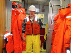
#WaterSafety - The latest Marine Notice from the Department of Transport, Tourism and Sport addresses pleasure and recreational craft owners, masters and users with a brief summary of the legal requirements in relation to the wearing and carrying of lifejackets and buoyancy aids, the penalties arising from non-compliance, as well as advice on the selection and maintenance of personal flotation devices, or PFDs.
The reminder follows from a previous notice in August 2012, and subsequent notices on the care and use of lifejackets, as well as the 27 January edition of This Island Nation concerning good habits over the wearing of PFDs.
Full details can be found in Marine Notice No 10 of 2016, a PDF of which is available to read or download HERE.
Marine Notice: Deployment Of Fish Tag Detectors In Galway Bay
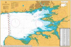
#MarineNotice - The latest Marine Notice from the Department of Transport, Tourism and Sport (DTTAS) advises that Inland Fisheries Ireland (IFI) and SmartBay Ireland will be carrying out the deployment of an underwater array of fish tag detectors in Galway Bay as outlined in Foreshore Licence FS6536.
The deployment operations for the array will take place between Spiddal and Blackhead and in the Corrib and Dunkellin estuaries, which are part of Galway Bay.
The acoustic array consists of 19 individual receivers as detailed in Marine Notice No 8 of 2016, a PDF of which is available to read or download HERE.
Deployment operations will be carried out by MV Tarrea Queen (Callsign EIAC3) and will take place from 3-17 March 2016. Subject to weather conditions, the operations may extend an additional two weeks following this planned period.
Each mooring/receiver will be marked with a subsurface buoy at a depth of >8m to avoid any potential fouling with any craft. All moorings and associated infrastructure will be removed following the completion of the study.
Consultation with fishermen was carried out during the Foreshore Licence process to ensure that equipment was not deployed in areas utilised by commercial fishermen.
All units will be clearly marked with IFI logos and numbered so that any unintentional retrieval can be notified to IFI through the contact details provided in the Marine Notice.
Marine Notice: Demersal Monkfish & Megrim Survey Off North Coast
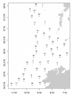
#MarineNotice - The latest Marine Notice from the Department of Transport, Tourism and Sport (DTTAS) advises that the Marine Institute is carrying out a monkfish and megrim trawl survey off the north of Ireland between Friday 26 February and Sunday 6 March 2016.
The survey consists of a maximum of 45 fishing stations of one-hour duration each in ICES (International Council for Exploration of the Sea) area VIa.
Bottom trawling will take place within a 3nm radius of the locations detailed in Marine Notice No 7 of 2016, a PDF of which is available to read or download HERE.
The survey will be conducted by the RV Celtic Explorer (Callsign EIGB), which will display all appropriate lights and signal during the survey and will also be listening on VHF Channel 16. The vessel will be towing a commercial monkfish demersal trawl during fishing operations.
The Marine Institute requests commercial fishermen to keep a 3 nm area around the tow points clear of all commercial gear during the period.
While there is no statutory provision for the loss of fishing gear, the Marine Institute will make every effort to avoid gear adequately marked according to legislation that may have drifted into the notified areas.
In the event that a fisherman has static gear or other obstructions within 3mn of the points listed, it is the responsibility of the owner to notify the survey managers or vessel directly using the contact information provided.
Marine Notice: Emergency Cable Repair On Approach To Dublin Port

#MarineNotice - The latest Marine Notice from the Department of Transport, Tourism and Sport advises that Global Marine Systems Ltd has been contracted to undertake an emergency repair to the ESAT2 submarine fibre optic telecommunications cable in the Irish Sea within Irish Territorial Waters on the approach to Dublin Port.
The CS Wave Sentinel (Callsign MZBC8) is scheduled to arrive on site tomorrow (Monday 22 February) to commence works. The weather is currently being monitored and this timing could change depending on local conditions.
The repair works will last for approximately five days depending upon weather and other operational conditions.
The vessel will be limited in manoeuvrability and other vessels should give the vessel and its equipment, including cable buoys, a wide berth. It will be listening on VHF Channel 16 during the project.
Full details are included in Marine Notice No 6 of 2016, a PDF of which is available to read or download HERE.
Marine Notice: New SOLAS Requirements For Verification Of Gross Mass Of Containers

#MarineNotice - The latest Marine Notice from the Department of Transport, Tourism and Sport details new SOLAS requirements for the verification of the gross mass of shipping containers.
Following concerns raised internationally by the shipping industry in relation to the mis-declaration of container weights, the International Maritime Organisation (IMO) has amended the Safety of Life at Sea Convention (SOLAS), Chapter VI, Regulation 2. These changes come into force internationally on 1 July 2016.
More details of these changes are included in Marine Notice No 5 of 2016, a PDF of which is available to read or download HERE.
Marine Notice: Caution On Use Of Unlicensed Electronic Navigational Systems & Software
#MarineNotice - Marine Notice No 4 of 2016 advises of the risks inherent in the use of unlicensed electronic navigation systems and cautions against their use.
Unlicensed software and electronic charts may contain errors, resulting in inaccuracies in displayed information and indicated vessel position. Such unlicensed software should not be used for navigation purposes.
Vessel operators are reminded of the requirement to carry suitable nautical instruments and adequate and up-to-date charts for their intended voyages. All equipment fitted in compliance with shipborne navigational equipment regulations should be type approved.
The installation and use of unlicensed navigational systems and software on-board commercial vessels may invalidate a vessel’s certification and may also lead to the cancelation of a vessel’s certificates.
If in doubt, vessel owners/operators should confirm with their suppliers that their software is up to date and licensed.
#MarineNotice - The latest Marine Notice from the Department of Transport, Tourism and Sport (DTTAS) advise that the Government has made an order under the Sea and Fisheries and Maritime Jurisdiction Act 2006 prescribing straight baselines from Malin Head to Carnsore Point.
The new order has been made following the resurvey of the 50 basepoints used in the 1959 system of straight baselines, employing modern geodetic surveying techniques.
The position of each basepoint is now recorded in co-ordinates of latitude and longitude accurate to five decimal places on the World Geodetic System 84 (WGS 84) datum.
This new order replaces the Maritime Jurisdiction (Straight Baselines) Order 1959 and comes into operation on 1 February 2016, though there is no change to the straight baselines system itself.
Full details of relevant co-ordinates are included in Marine Notice No 3 of 2016, a PDF of which is available to read or download HERE.
Global Recall Notice Issued for Kannad SAFELINK EPIRBs
The Department of Transport, Tourism and Sport has advise it has been informed that Kannad Marine, the manufacturer of Kannad SAFELINK EPIRBS, have issued a Global Recall Safety Notice of the following affected EPIRB units:
Part No.’s Affected Description Date Range
K1202311 EPIRB SAFELINK Manual+ GPS All
K1202367 EPIRB SAFELINK Auto GPS All
Full notice downloaadable below
#MarineNotice - The first Marine Notice of 2016 from the Department of Transport, Tourism and Sport (DTTAS) advises that the Dublin Institute for Advanced Studies (DIAS) is deploying 10 Ocean Bottom Seismometers for a period of seven months off the North West Coast of Ireland.
The OBS units will be deployed from the Marine Institute vessel RV Celtic Voyager between 13 and 22 January. They will be free-falled to the bottom and anchored by a 400kg clump weight.
The OBS units in shallow water will have a yellow surface marker buoy and a yellow flashing light with the following characteristics: FL (5) Y 20s and with a range of 2 nautical miles.
Station 1 will be located close to the M4 Weather Buoy which is the subject of a prior marine notice (No 11 of 2007).
As this is sensitive scientific equipment, it is requested that fisherman and marine operators engaged in such activities as bottom trawling or laying of static gear avoid the locations concerned to avoid damaging the equipment or damaging fishing gear.
Full co-ordinates of the OBS locations are included in Marine Notice No 1 of 2016, a PDF of which is available to read or download HERE.
#MarineNotice - The latest Marine Notice from the Department of Transport, Tourism and Sport (DTTAS) advises that a Marine Institute monkfish and megrim trawl survey will be carried out off the west and southwest coasts of Ireland between 4 and 24 January 2016.
The survey consists of a maximum of 70 fishing stations of one-hour duration each in ICES (International Council for Exploration of the Sea) areas VIIb, c,g, h,j.
Approximate positions for these hauls are given in Figure 1 and Table 1 included in Marine Notice No 52 of 2015, a PDF of which is available to read or download HERE.
Bottom trawling will take place within a 3-nautical0mile radius of these locations.
The survey will be conducted by the RV Celtic Explorer (Callsign: EIGB). The vessel will display all appropriate lights and signal during the survey and will also be listening on VHF Channel 16.
She will be towing a commercial monkfish demersal trawl during fishing operations. The Marine Institute would request commercial fishermen to keep a 3-nautical-mile area around the tow points clear of all commercial gear during the period.
While there is no statutory provision for the loss of fishing gear, the Marine Institute will make every effort to avoid gear adequately marked according to legislation (Articles 9-17 of EU Regulation 404-2011) that may have drifted into the notified areas.
In the event that a fisherman has static gear or other obstructions within 3 nautical miles of the points listed above, it is the responsibility of the owner to notify the survey managers or vessel directly via the following contacts:
- Aodhan Fitzgerald, Marine Institute: 087 248 8765
- Hans Gerritsen: [email protected]


 linking Spain.")


 Michael Murphy Schull Harbour Sailing Club (SHSC), Eric Coogan Heineken Ireland, Mark Murphy, Commodore SHSC, Jack Allen SHSC, Carmel O'Regan SHSC, Cornelious Ndlovu, Schull Harbour Hotel Operations Manager and Derval Murphy SHSC")


