


Displaying items by tag: Meelick weir
Waterways Ireland’s Restored Meelick Weir & Walkway is Officially Opened
The restored Meelick Weir and walkway on the River Shannon have been officially opened by Minister for Housing, Local Government and Heritage, Darragh O’Brien TD and Minister of State for Heritage and Electoral Reform, Malcolm Noonan TD.
The weir was damaged in severe storms in 2009 and again in 2015/2016, when the walkway was also damaged and was subsequently closed.
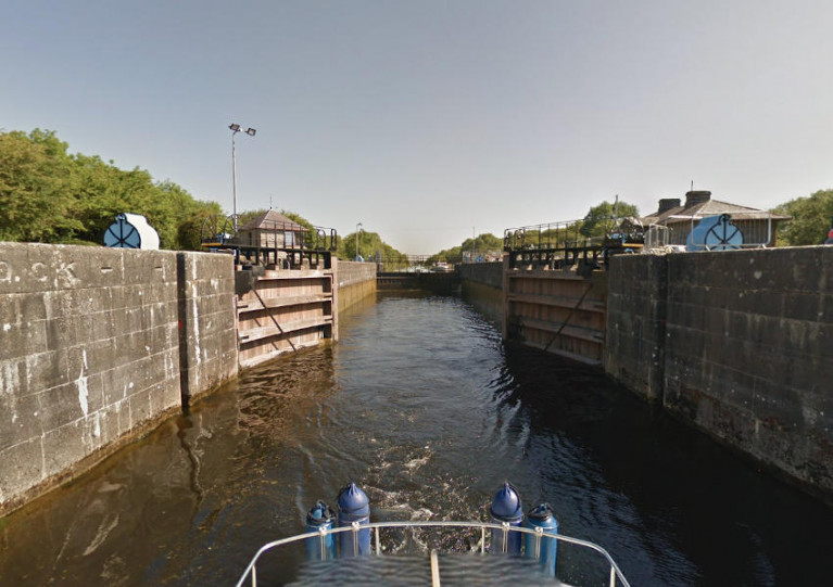
The infrastructure links the historic village of Meelick in east Galway to Lusmagh in west Offaly and forms part of the Hymany Way and the Beara-Breifne Way walking trails. The weir was built in the 1840s as part of the Shannon Navigation. More than 300 metres in length, it has a 12-sluice barrage and maintains and regulates the navigation level for the section of the waterway between Athlone (Lough Ree) and Meelick (Lough Derg).
Construction work on the €3.2m Waterways Ireland project began in 2019 and included the restoration of the weir, its 300m walkway and new tilting weir gates, along with other weir refurbishments. The new tilting weir system will be mechanised, meaning that staff will no longer have to manually install and remove the sluice boards in response to changing water levels.
Speaking at the official opening, Minister for Housing, Local Government, and Heritage, Minister Darragh O’Brien said: “I am delighted to be here today to officially open Meelick Weir and walkway after the completion of a hugely significant programme of work by Waterways Ireland on this state-of-the-art project. Recognising the importance of the weir and the walkway, I was pleased to support the project and to ensure funding was made available from my Department in the amount of €3.2m. It is great to see it brought to completion and ready for its official opening today.
“Meelick Weir has a dual purpose, not only is it a critical piece of infrastructure in maintaining the navigation level between Lough Ree and Lough Derg, it also serves to unite the communities of Meelick and Lusmagh and offers a fantastic amenity in the area. I know this is very popular with local people and also provides a wonderful tourism opportunity for Galway, Offaly and Tipperary – the three counties that it borders. The restoration of the weir and walkway opens the potential for these historic structures to play an important role in tourism in the future.”
The area surrounding Meelick Weir is also of huge historical significance, with Victoria Lock and its lock-keeper’s house, and Meelick Martello, located on Moran Island, all included on the Record of Protected Structures. Meelick Martello is a recorded monument in the care of Waterways Ireland. Nearby Meelick Church, meanwhile, dates back to the 1400s.
Minister for Heritage, Malcolm Noonan commented: “This whole area is hugely significant from a heritage perspective. This project opens the walkway and allows people to travel its route to visit Victoria Lock, which was built in the 1840s also as part of the navigation system, and the famous landmark ‘the three counties Shannon view,’ where the counties of Galway, Offaly and Tipperary meet. In terms of wildlife, it is within both the River Shannon Callows Special Area of Conservation and the Middle Shannon Callows Special Protection Area.”
He added: “I am delighted to see the restoration of the connectivity between the communities of Lusmagh and Meelick and the reinstatement of the Hymany Way. This project will have a significant impact on the communities and the broader tourism opportunities in the area.”
Waterways Ireland chief executive, John McDonagh said: “Meelick Weir is an iconic structure and I’m delighted that this restoration project is now complete. The weir is an extremely important piece of navigation infrastructure, enabling the management of water levels on the River Shannon for navigation, and also linking the counties of Offaly and Galway, and the provinces of Leinster and Connaught via the walkway. The systems built into the weir also ensure a safer working environment for our staff.
“This is the largest project Waterways Ireland has undertaken since we restored the mainline of the Royal Canal and I would like to commend my colleagues, who have worked diligently to deliver this ambitious project on budget in very challenging times.”
Warning Reissued Over Low Water Levels On Shannon Navigation At Meelick Weir & Victoria Lock
Waterways Ireland advises masters and owners of vessels that low water levels exist on the upstream approaches to Meelick and Victoria Lock, north of Portumna on the Shannon Navigation.
Water levels are currently up to 39cm below summer levels as the sluices are open at Meelick Weir, which creates a draw-down of water levels in the area.
Masters of vessels, particularly those with deep drafts, are advised to navigate with additional caution and to remain within the navigation at all times.

Waterways Ireland has announced the closure of the walkway at Meelick Weir on the Shannon Navigation in Co Galway from today, Saturday 2 January until further notice.
The closure of the walkway is at the request of An Garda Siochana due to what is claimed are issues with compliance with social distancing protocols on and near the walkway along the inland waterway.
Waterways Ireland advises masters and owners of vessels that low water levels exist on the upstream approaches to Meelick Weir and Victoria Lock, north of Portumna on the Shannon Navigation.
Water levels are currently up to 45cm below summer levels as weir boards are out at Meelick Weir, which creates a draw-down of water levels in the area.
Masters of vessels, particularly those with deep drafts, are advised to navigate with additional caution and to remain within the navigation at all times.
#InlandWaters - Seán Kyne, Minister of State at the Department of Culture, Heritage and the Gaeltacht, has announced a €3.2 million investment by Waterways Ireland infrastructure on the Shannon Navigation at Meelick Weir.
The funds will be used for the restoration and replacement of the Meelick Weir walkway, the installation of tilting weir boards and remedial works to the weir structure.
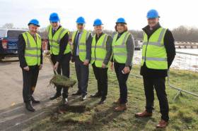
The minister was joined on site yesterday (Friday 1 March) by Éanna Rowe, regional manager with Waterways Ireland and by Ministers of State Seán Canney Ciarán Cannon, along with Anne Rabbitte TD and local community representatives.
Meelick Weir was originally built in the 1790s as part of the Shannon Navigation. The weir, which is over 300 metres in length with a 12-sluice barrage, maintains and regulates the navigation level for that section of waterway between Athlone (Lough Ree) and Meelick (Lough Derg).
The weir and its walkway link the historic village of Meelick in Co Galway to Lusmagh in Offaly, and also link into the Hymany Way walking trail. The weir was damaged during storms in 2009 and the walkway was closed following further storms in 2015 and 2016.
Speaking yesterday, Minister Kyne said: “I am fully aware of the importance of this restoration to the counties of Galway and Offaly and in particular to the local communities of Lusmagh and Meelick who have been without the walkway for a number of years now.”
He added: “Meelick Weir is not just a walkway but a hidden gem on the River Shannon and its restoration shows the Government’s commitment to supporting all aspects of rural Ireland`s economic development.”
Éanna Rowe of Waterways Ireland said: “The development and re-instatement is critical to the management of the navigation and regulation of water levels.
“Reopening the connectivity between the communities of Lusmagh and Meelick and the re-instatement of the link to the Hymanny is a hugely positive and significant development for both communities.”
Waterways Ireland initiated design work on the project in 2012, completed the statutory environmental assessment and submitted planning for the project to Galway and Offaly county councils, which was given in 2017.
The works will involve the restoration of the weir, its walkway and the tilting weir boards along with the other critical infrastructure requirements (replacement of lock gates, jetty replacement, embankment works and bridge strengthening).
The new tilting weir system is being touted as a significant improvement in health and safety for employees managing water levels on site.
Following an open tendering procedure, a contractor will be shortly appointed and the project will be completed mid-2020.
Galway Councillors Put Shannon Flooding Decision On Hold

#SHANNON FLOODING - Galway Bay FM reports that Galway county councillors have postponed making any decision on an Oireachtas report into flooding in areas adjacent to the River Shannon.
The move was taken on the suggestion of Cllr Dermot Connolly in the wake of a joint Dáil and Seanad committee report that highlights eight proposals for dealing with flooding issues along the longest of Ireland's inland waterways.
Cllr Michael Connolly has suggested that Minister for the Environment Phil Hogan and Minister for the Gaeltacht Jimmy Deenihan should meet to discuss the report's findings from both a flooding and environmental stance.
Meanwhile, the Irish Independent reports that the Office of Public Works (OPW) has agreed to carry out tests at Meelick weir on the Shannon in Co Offaly after thousands of acres of farmland were flooded over the summer, ruining silage crops and summer grazing land.
Waterways Ireland has denied allegations that a failure to open sluices and lift boards at the weird contributed to the flooding.


 at Dublin when bound for Holyhead; such high-speed craft 'seasonal’ services resume next month")
. He learned his sailing in the Royal Cork at Crosshaven but left Ireland (as did many others) in 1985 and is now so into America’s West Coast sailing scene that he owns a classic Cal 40")


 Michael Murphy Schull Harbour Sailing Club (SHSC), Eric Coogan Heineken Ireland, Mark Murphy, Commodore SHSC, Jack Allen SHSC, Carmel O'Regan SHSC, Cornelious Ndlovu, Schull Harbour Hotel Operations Manager and Derval Murphy SHSC")

