


Displaying items by tag: Mutton Island
#Search - Galway Bay FM reports that coastal searches resumed this afternoon in Galway for a man who was spotted entering the water last night (Thursday 10 March).
The search began in Galway Docks after the man, believed to be in his 30s, was seen entering the water at Wolfe Tone Bridge over the Corrib, but no trace has been found.
A separate search for a person calling for help on the shoreline near Mutton Island has also yielded no results thus far, and it is not yet known if the two events are related.

#GalwayBay - A Galway City Council official has denied claims that raw sewage from a treatment plant at Mutton Island is being discharged into Galway Bay.
As the Galway Advertiser reports, Ciarán Hayes told a special meeting of the council last Monday 15 April that he "would not like the impression to go out that we would allow sewage to be discharged, it's not".
Hayes was responding to questions from Cllr Catherine Connolly with regard to tenders issued for the upgrading of the treatment plant, which forms part of the Galway Main Drainage Stage 3 and which has been approved for funding from the Department of Environment.
He added that the current system is licences by the Environmental Protection Agency (EPA) and "is in accordance with industry best practice".
Meanwhile, the meeting also discussed a proposed extension of pedestrian access to Mutton Island lighthouse, which as previously reported on Afloat.ie was opened to tour groups last year after extensive refurbishment since 2005.
The Galway Advertiser has more on the story HERE.
Raw Sewage Outfall Concern for Galway Residents

#GALWAY BAY - Galway residents are voicing fears over pollution in Galway Bay due to alleged increase in outfalls from the city's sewage system.
As Galway News reports, locals in the Claddagh area spotted a discharge of raw sewage into the Claddagh Basin in July, which was confirmed by City Councillor Catherine Connolly to be an outfall.
Such releases are triggered automatically, like a safety valve, in emergency circumstances, such as after heavy rainfall which backs up the system.
Cllr Connolly has expressed her concern over an increase in the number of such releases over recent months, and their potential contribution to the degradation of water quality in the area - especially following the temporary closure of Grattan Beach in Salthill last month due to E.coli contamination.
She has also called for a report from the council on the difficulties experiences at the Mutton Island water treatment plant resulting from the inflow of grease and fats into the system from hotels and restaurants.
Galway News has more on the story HERE.
New Archaeological Discoveries in Galway Bay

#GALWAY BAY NEWS - Archaeologists in Galway Bay have unearthed an extensive tidal weir complex at Barna and a late medieval quay on Mutton Island, The Irish Times reports.
The weir, which is estimated to date from the early Christian period, consists of a granite barrier with channels cut through it, designed to control the flow of water in the adjacent lagoon.
Connemara archaeologist Michael Gibbons suggests that the weir implies a considerable fish stock migrating through the area into the Barna river.
The remains of a large Iron Age fort which overlooks the site may also have given its name to the townland of Knocknacarra, which is now a populous suburb of Galway.
Meanwhile, further east at Mutton Island a medieval quay which predates the current lighthouse quay has been found.
The Irish Times has more on the story HERE.
New Radar System Could Improve Coastal Forecasts

A new radar system in Galway could help predict extreme weather events more accurately, The Irish Times reports.
Scientists at NUI Galway's Ryan Institute, in collaboration with the IBM Smarter Cities Technology Centre in Dublin, have installed the system on the shoreline in Galway Bay.
The system - the first of its kind in North Atlantic Europe - consists of two antennae, on Mutton Island and Spiddal, which scan the surface of the bay every half hour.
It then sends high-resolutions maps of surface currents and details of wave height and direction directly to the scientists' base at the NUIG campus.
The data is used, along with meteorological data, to develop models for forecasing marine conditions from tidal currents to storm surges - common on the challenging coastline around Galway Bay and the Aran Islands.
Moreover, the system is set to benefit the local community and beyond as the data, when completed, will be made freely available.
Silicon Republic says that the Galway Bay Coastal Observing System (GalCOS) could be used by sailors, fishermen and tourists to more accurately assess conditions in the area.
It could also be of use to local authorities in terms of providing details on the best time to release effluent while minimising environmental damage.
“This type of predictive modelling is critical to our Smarter Cities agenda," said IBM's Dr Lisa Amini, "and the findings can be widely applied to protect coastal cities and their environments."
Mutton Island Lighthouse To Shine Once More
The refurbished Mutton Island lighthouse in Galway Bay will open to tour groups on a regular basis next year, the Galway City Tribune reports.
Once one of the final landmarks of the city seen by emigrants leaving on the 'coffin ships' bound for the United States in the Great Famine, its light last shone in 1977.
The protected lighthouse and its island were purchased by Galway City Council for a total of £2, and since then the 18th-century building fell into disrepair - although the island thrived as a sanctuary for artic terns and Claddagh swans.
But in 2005 a project was intitiated by Galway City Council and the Galway Civic Trust, involving FÁS trainees to restore the lighthouse and its grounds to their former glory, and the fruits of this labour are set to be unveiled next spring.
Recent free tours of the building for Hertiage Week were hugely popular, providing high hopes for the lighthouse and its gardens to become a valuable new amenity for the City of the Tribes.
The Galway City Tribune has more on the story HERE.
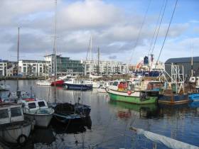
Cruise-Goers Head for the Galway Races
The vessel first visited Galway in 2009 but this call will be her last year operating under the Spirit of Adventure cruise banner. The company are to replace the vessel next season with the Saga Pearl II which will be transferred from the parent company Saga Cruises and renamed Quest for Adventure.
Prior to the Spirit of Adventurer's call, the 226 passenger Le Diamant arrived from St. Malo last Friday. She became the first vessel to make a call to the 'City of the Tribes' on behalf of her French operators, Cie de Ponant. Her passengers were taken on tours of the city, Connemara and the Aillwee Caves in neighbouring Co. Clare. The vessel is due to return early next month.
With three cruise-calls this year the port is set to increase this figure to 7 in 2012 arising from the ports campaign over the last two years. Paul Carey, Chairman of the Harbour Company, said "We are beginning to see the fruits of this campaign and look forward to growing Galway's association with the return of the majestic passenger liners to Galway".
"The passenger liner The World has been confirmed for a two-day visit in August 2013 which is a great endorsement of Galway as a cruise destination".
The call by the world's first ocean-going luxury resort vessel will also be another first for Galway. Operators of the 43,524gt vessel, Residences at Sea have made previous Irish ports of call to include Dublin, for more on her to the capital last August click HERE.
- Dublin Port
- Galway Bay
- Foynes
- Shannon Estuary
- The World
- Cruiseships
- Ports and Shipping News
- city of the tribes
- Galway Harbour
- Galway Harbour News
- Mutton Island
- Le Diamant
- Cruiseliners
- Saga Cruises
- Spirit of Adventure Cruises
- Spirit of Adventure
- Galway Harbour and Bay news
- Galway Port
- Port of Galway Company
- Ponant Cruises
- Galway Races
- The Galway Races Ballybrit
- Ballybrit Race Course
- Port of Foynes
- Saga Pearl II
- Quest for Adventure
- Shannon Estuary and port news
- The World cruise liner
- Residences at Sea
- The World Residences at Sea
- Irish cruise ports of call
- Irish cruise calls
- Cruiseships to Ireland
- Cruise Companies visiting Ireland
- West of Ireland cruise callers
Irish Private Islands Up For Sale

Three private islands off Ireland's west coast are now up for sale - with the cheapest being a snip at just €150,000.
Irish Central reports that the three islands are currently offered via the website privateislandonline.com which aims at the rich-and-famous market.
Mannions Island, in west Cork's Dunmanus Bay, is priced less than the average family home in Dublin. For €150,000 the buyer gets a four-acre island that's 60% fertile just 200m from the shore (the catch is that there are no buildings).
Further up the coast at Clew Bay in Co Mayo is Island Mor, a 70-acre gem with views of the Inish Gort lighthouse and Croagh Patrick, which is going for €902,000. The location is a popular one for celebs - John Lennon was once an owner in Clew Bay.
Last but not least is Mutton Island, a mile from Seafield Harbour in Co Clare and just 20 miles south of the Aran Islands. The largest of the three at 185 acres, it also has a storied history, with the first recorded human settlement in 548 AD. Price is available on request.


 located at Ringsend on the south bank of Dublin Port. AFLOAT also add the Group over the last decade has invested over €30 million across MTL’s infrastructure and the terminal has a throughput of 250,000 TEU’s per year, with direct LoLo connections with ports in Central Europe and Irish Sea as well as feeder services connecting us with the Far East, India and South America.")

 linking Spain.")


 Michael Murphy Schull Harbour Sailing Club (SHSC), Eric Coogan Heineken Ireland, Mark Murphy, Commodore SHSC, Jack Allen SHSC, Carmel O'Regan SHSC, Cornelious Ndlovu, Schull Harbour Hotel Operations Manager and Derval Murphy SHSC")


