Menu

Ireland's sailing, boating & maritime magazine

Displaying items by tag: National Salmon Scale Project

Anglers are needed as citizen scientists for a new National Salmon Scale Project, says Sean Canney TD, Minister of State with responsibility for the inland fisheries sector.

Minister Canney said: “As we celebrate International Year of the Salmon, this project will help researchers understand the challenges which salmon are facing today.

“The project, which has been initiated by Inland Fisheries Ireland, aims to collect vital information through scales taken from salmon and sea trout which are caught in Irish rivers and lakes and will contribute to international efforts to conserve wild salmon.”

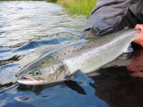
Fish scales record the life history of a salmon, and one scale can reveal a lot about the lifestyle and behaviour of the fish.

Scales can tell scientists what age the fish is, how many winters it spent at sea, how many times it spawned, how slow or fast it grew, what it ate and how long it spent in the river before it went out to sea.

Scales can also reveal the general feeding area where the salmon travelled to in the ocean, whether it went to the Faroe Islands, the Norwegian Sea or all the way to West Greenland. Scales help scientists to understand the biology and ecology of Irish salmon and sea trout.

As part of the project, anglers are asked to take a scale sample from a salmon or sea trout by gently scraping and removing approximately 20 fish scales using a clean knife, then post their samples to Inland Fisheries Ireland (IFI) using the sample envelopes which will be made available to them.

Scales can be removed from both harvested and catch-and-release fish. Sampling of fish for release should be handled carefully and fish should be only briefly removed from the water with every effort made to avoid injury or stress while weight should be estimated.

Information from salmon scales is used in setting conservation limits for Irish rivers. Conservation limits for each river are set based on the proportion of salmon who have spent one winter at sea and those that have spent multiple winters at sea.

The conservation limit for a river represents the number of spawning salmon required to produce the next generation of salmon and this information helps inform angling regulations and management. Information from scales on multi-sea winter salmon entering rivers in spring is also important for managing individual river stocks.

Dr Paddy Gargan, senior research officer at IFI, said: “It is important to have anglers collecting scales as they can provide broad coverage across Ireland and collect scales throughout the fishing season.

“A scale resource which includes many different river systems in Ireland over several years is a great asset from a research perspective as it allows us to examine the factors affecting salmon survival at sea. We can compare how factors, such as climate change, are impacting survival by analysing today’s salmon scales alongside those from many decades ago.”

All scales collected through the National Salmon Scale Project will be added to the National Salmon Scale Archive which is managed by IFI.

The archive, which consists of a dedicated storage facility and associated database, currently holds 19,300 scale samples from a total of 38 rivers representing 152 sampling years. The National Salmon Scale Project aims to increase the scale resource available to scientists for ongoing and future research.

IFI’s head of research and development Dr Cathal Gallagher said: “Ultimately the National Salmon Scale Project will help inform future salmon management policies and activities.

“It is fitting therefore that we are launching this campaign during International Year of the Salmon which aims to raise awareness of what humans can do to ensure salmon and their habitats are conserved and restored against a backdrop of several environmental pressures. This project offers anglers a very tangible and practical way of playing an active role in salmon conservation.”

For more information on the National Salmon Scale Project, including how to take a sample safely and to request sample envelopes, visit the project webpage. To find out more about International Year of the Salmon visit YearOfTheSalmon.org.

Published in Angling

About Dublin Port 

Dublin Port is Ireland’s largest and busiest port with approximately 17,000 vessel movements per year. As well as being the country’s largest port, Dublin Port has the highest rate of growth and, in the seven years to 2019, total cargo volumes grew by 36.1%.

The vision of Dublin Port Company is to have the required capacity to service the needs of its customers and the wider economy safely, efficiently and sustainably. Dublin Port will integrate with the City by enhancing the natural and built environments. The Port is being developed in line with Masterplan 2040.

Dublin Port Company is currently investing about €277 million on its Alexandra Basin Redevelopment (ABR), which is due to be complete by 2021. The redevelopment will improve the port's capacity for large ships by deepening and lengthening 3km of its 7km of berths. The ABR is part of a €1bn capital programme up to 2028, which will also include initial work on the Dublin Port’s MP2 Project - a major capital development project proposal for works within the existing port lands in the northeastern part of the port.

Dublin Port has also recently secured planning approval for the development of the next phase of its inland port near Dublin Airport. The latest stage of the inland port will include a site with the capacity to store more than 2,000 shipping containers and infrastructures such as an ESB substation, an office building and gantry crane.

Dublin Port Company recently submitted a planning application for a €320 million project that aims to provide significant additional capacity at the facility within the port in order to cope with increases in trade up to 2040. The scheme will see a new roll-on/roll-off jetty built to handle ferries of up to 240 metres in length, as well as the redevelopment of an oil berth into a deep-water container berth.

Dublin Port FAQ

Dublin was little more than a monastic settlement until the Norse invasion in the 8th and 9th centuries when they selected the Liffey Estuary as their point of entry to the country as it provided relatively easy access to the central plains of Ireland. Trading with England and Europe followed which required port facilities, so the development of Dublin Port is inextricably linked to the development of Dublin City, so it is fair to say the origins of the Port go back over one thousand years. As a result, the modern organisation Dublin Port has a long and remarkable history, dating back over 300 years from 1707.

The original Port of Dublin was situated upriver, a few miles from its current location near the modern Civic Offices at Wood Quay and close to Christchurch Cathedral. The Port remained close to that area until the new Custom House opened in the 1790s. In medieval times Dublin shipped cattle hides to Britain and the continent, and the returning ships carried wine, pottery and other goods.

510 acres. The modern Dublin Port is located either side of the River Liffey, out to its mouth. On the north side of the river, the central part (205 hectares or 510 acres) of the Port lies at the end of East Wall and North Wall, from Alexandra Quay.

Dublin Port Company is a State-owned commercial company responsible for operating and developing Dublin Port.

Dublin Port Company is a self-financing, and profitable private limited company wholly-owned by the State, whose business is to manage Dublin Port, Ireland's premier Port. Established as a corporate entity in 1997, Dublin Port Company is responsible for the management, control, operation and development of the Port.

Captain William Bligh (of Mutiny of the Bounty fame) was a visitor to Dublin in 1800, and his visit to the capital had a lasting effect on the Port. Bligh's study of the currents in Dublin Bay provided the basis for the construction of the North Wall. This undertaking led to the growth of Bull Island to its present size.

Yes. Dublin Port is the largest freight and passenger port in Ireland. It handles almost 50% of all trade in the Republic of Ireland.

All cargo handling activities being carried out by private sector companies operating in intensely competitive markets within the Port. Dublin Port Company provides world-class facilities, services, accommodation and lands in the harbour for ships, goods and passengers.

Eamonn O'Reilly is the Dublin Port Chief Executive.

Capt. Michael McKenna is the Dublin Port Harbour Master

In 2019, 1,949,229 people came through the Port.

In 2019, there were 158 cruise liner visits.

In 2019, 9.4 million gross tonnes of exports were handled by Dublin Port.

In 2019, there were 7,898 ship arrivals.

In 2019, there was a gross tonnage of 38.1 million.

In 2019, there were 559,506 tourist vehicles.

There were 98,897 lorries in 2019

Boats can navigate the River Liffey into Dublin by using the navigational guidelines. Find the guidelines on this page here.

VHF channel 12. Commercial vessels using Dublin Port or Dun Laoghaire Port typically have a qualified pilot or certified master with proven local knowledge on board. They "listen out" on VHF channel 12 when in Dublin Port's jurisdiction.

A Dublin Bay webcam showing the south of the Bay at Dun Laoghaire and a distant view of Dublin Port Shipping is here
Dublin Port is creating a distributed museum on its lands in Dublin City.
 A Liffey Tolka Project cycle and pedestrian way is the key to link the elements of this distributed museum together.  The distributed museum starts at the Diving Bell and, over the course of 6.3km, will give Dubliners a real sense of the City, the Port and the Bay.  For visitors, it will be a unique eye-opening stroll and vista through and alongside one of Europe’s busiest ports:  Diving Bell along Sir John Rogerson’s Quay over the Samuel Beckett Bridge, past the Scherzer Bridge and down the North Wall Quay campshire to Berth 18 - 1.2 km.   Liffey Tolka Project - Tree-lined pedestrian and cycle route between the River Liffey and the Tolka Estuary - 1.4 km with a 300-metre spur along Alexandra Road to The Pumphouse (to be completed by Q1 2021) and another 200 metres to The Flour Mill.   Tolka Estuary Greenway - Construction of Phase 1 (1.9 km) starts in December 2020 and will be completed by Spring 2022.  Phase 2 (1.3 km) will be delivered within the following five years.  The Pumphouse is a heritage zone being created as part of the Alexandra Basin Redevelopment Project.  The first phase of 1.6 acres will be completed in early 2021 and will include historical port equipment and buildings and a large open space for exhibitions and performances.  It will be expanded in a subsequent phase to incorporate the Victorian Graving Dock No. 1 which will be excavated and revealed. 
 The largest component of the distributed museum will be The Flour Mill.  This involves the redevelopment of the former Odlums Flour Mill on Alexandra Road based on a masterplan completed by Grafton Architects to provide a mix of port operational uses, a National Maritime Archive, two 300 seat performance venues, working and studio spaces for artists and exhibition spaces.   The Flour Mill will be developed in stages over the remaining twenty years of Masterplan 2040 alongside major port infrastructure projects.

Source: Dublin Port Company ©Afloat 2020.