


Displaying items by tag: Navigation
The General Lighthouse Authorities (GLA) have announced a review of the Aids to Navigation (AtoN) provision around the coasts of Ireland and Great Britain.
Trinity House will publish the results of the review in 2025, the outcomes of which will inform the GLAs’ work plans for the following five-year period.
The GLA provide a comprehensive and sustainable network of AtoN for General Navigation and are responsible for the Superintendence and Management of Local AtoN provided by Local Lighthouse Authorities.
The GLA has said that they consider user input to be an essential part of this review. Users of AtoN are encouraged to contribute to the review by commenting on:
- The usefulness and usability of existing AtoN provided by the GLAs.
- Any proposed requirement for the provision of new AtoN.
- The mix of AtoN provided including lighthouses, buoys, beacons, Racons and AIS AtoN.
- The benefit to users of providing additional data from AtoN such as meteorological data.
- The effectiveness of systems used to promulgate information relating to AtoN.
- Any other AtoN related issues.
You can find the full details of how to respond to the Aids to Navigation Review on the Trinity House website. The closing date for responses is Friday 31 May.
Garmin Unveils New GPSMAP 9000 Series Chartplotters in 4K
Marine electronics manufacturer Garmin has unveiled its flagship GPSMAP 9000 series of all-in-one chartplotters boasting 4K resolution for maximum detail.
Available with 19”, 22”, 24” or 27” touchscreen displays, the new series is powered by a processor that’s seven times faster than previous generations.
For superior clarity and sunlight readability, the in-plane switching (IPS) touchscreen displays provide consistent, accurate colours that can be seen from all viewing angles, even with polarised sunglasses.
And for the first time, anglers can see fish and sonar targets in stunning 4K high definition, too, by adding a Garmin GSD sonar module, Panoptix transducer or LiveScope sonar.

“For decades, mariners have been relying on Garmin’s GPSMAPs to help them navigate waters all over the world,” says Garmin’s Dan Bartel.
“Building on that success, we’re thrilled to unveil the 9000 series with bigger, best-in-class displays, lightning-fast processing speeds and the ultimate connected boating experience on the new Garmin BlueNet network.”
Another key feature is the ability to integrate with onboard computer systems for engine monitoring, camera-assisted docking, entertainment and even helm control.
Expected to be available next month, the GPSMAP 9000 series starts at €10,499.99. To learn more, visit garmin.com/marine.
Members of the National Yacht Club are invited to a talk on safe navigation in Dublin Bay, hosted by Dublin Port Company on Thursday 23 February at 7.30pm.
The talk will be will be presented by members of the port operations team. For details contact the NYC office.
The UK Hydrographic Office (UKHO) has announced that it will be phasing out the manufacturing of paper charts, with the aim to completely end production by late 2026.
Plans to withdraw the UKHO’s portfolio of ADMIRALTY Standard Nautical Charts (SNCs) and Thematic Charts are in response to more marine, naval and leisure users primarily using digital products and services for navigation, the office says.
It also emphasises that the ADMIRALTY Maritime Data Solutions digital navigation portfolio has the added benefits of being updated in near real-time and therefore greatly enhancing safety of life at sea (SOLAS).
The decision comes as the sale of paper charts has fallen from making up 80% of sales in 2018 to just 16% in 2021, the UKHO says.
It’s also been confirmed that in parallel with the process to withdraw the paper charts, the UKHO will be developing “viable, digital alternatives” for users who are still currently relying on using paper chart products.
The UKHO says it will be working closely with the Maritime Coastguard Agency (MCA) and other stakeholders to ensure that the new maps are fit for recreational navigation purposes.
The RYA says it believes the UKHO has a responsibility to provide support to recreational boaters through the provision of hydrographic information, products and services in a range of formats and media that is suitable for and easily usable by all recreational craft.
RYA director of training and qualifications Richard Falk said: “The RYA understand that the UKHO’s decision to end the production of paper charts may result in a feeling of significant change for some recreational boaters.
“However, the UKHO have given assurance that with the introduction of the digital navigation portfolio there will not be a compromise on navigational functionality, but instead an increase in data accuracy and ultimately, safety at sea.
“With careful management, we are hopeful that the new digital charts will improve navigation for recreational boaters and, as a key stakeholder, look forward to working with the UKHO to support them on this exciting new chapter for navigation.
"It is important to highlight for those who wish to continue navigating using paper charts and more traditional navigational techniques, there are other providers of paper charts within the market.
“The RYA will continue to teach both traditional and electronic navigational techniques through its range of courses, although over time it is right to expect the weighting of emphasis to shift towards more digitally based techniques.”
Further information and answers to FAQs about the change to digital charts can be found on the ADMIRALTY website.
Marine Notice: Importance of Voyage Planning for Fishing Vessels in Adverse Weather and Sea Conditions
In response to recommendations in the Marine Casualty Investigation Board (MCIB) report into the fatal incident involving the FV Myia in Galway Bay in November 2020, as previously reported on Afloat.ie, the Department of Transport is stressing the importance of navigation planning.
The necessity of ensuring all navigation is planned in detail from berth to berth, with contingency plans in place, applies to all concerned in the fishing industry.
Owners and relevant crew members need to familiarise themselves with their vessel, including its anchoring arrangements and any limitations of the anchoring equipment.
Owners and masters are also reminded that an efficient navigational watch shall be maintained throughout the voyage in line with the Basic Principles to be observed in keeping a Navigational Watch on Board Fishing Vessels as set out IMO Resolution A.484 (XII). Situational awareness with regard to navigation shall be maintained at all times.
All voyages must be planned using the most up to date nautical publications and approved admiralty charts and/or ECDIS. It is essential to carry out regular weather forecast checks during coastal, offshore and ocean voyages.
Shipowners, masters, skippers and fishers should particularly consider the following points when planning on going to sea:
- Weather: Prior to proceeding to sea, weather forecasts shall be assessed and the means to obtain available weather forecast updates shall be ensured. The prevailing weather shall be monitored at all times. Where weather conditions are deteriorating and the safety of the vessel or crew is in question, operators should seek shelter or return to port.
- Tides: The state of the tide and current should be determined for the planned voyage, task or activity. Masters and skippers shall ensure that the vessel or craft can be safely operated in the states of expected tide or current.
- Limitations of the vessel: Ensure the vessel is suitable for the planned voyage, task or activity, that all systems are available and in good operational condition, including all appropriate safety systems and equipment which shall, at all times, be ready for immediate use.
- Crew: Take into account the experience and physical ability of the crew. Crews suffering from cold, tiredness and seasickness won’t be able to do their job properly and this could result in an overburdened skipper. Prior to proceeding to sea, crew members should be well rested, fit and physically capable for any task that they may be required to perform whilst onboard. Masters and skippers should be aware of dangers of, and be able to recognise, fatigue and its impact on the safety of the vessel or craft.
- Communications: VHF radio should be available onboard which is capable of operating on marine band Channel 16 to raise a distress and/or seek assistance. Skippers should not rely on mobile phones as signal availability can be reduced or lost due to range from shore and environmental conditions. Skippers should, prior to departure, advise the port authority or a designated person ashore of planned area of operation and expected time of return.
Irish Lights Recruiting for Navigation Advisory Services Officer
Irish Lights is currently recruiting for a Navigation Advisory Services Officer on a specified purpose contract for a minimum duration of eight months.
It’s described as “an exciting opportunity for an experienced mariner with commercial sea-going and/or shore-based experience”.
The successful candidate will assist Irish Lights to meet some of the additional requirements identified in its strategy Safe Seas – Connected Coasts.
The role requires a mix of regulatory and business development skillsets. Previous experience in defining and developing new services for commercial clients would be an advantage.
This varied, shore-based role will involve a mix of office-based work in Dun Laoghaire and a significant amount of time on the coast.
Applicants must be Officer of the Watch (Deck) STCW 95 or fishing- or naval-equivalent qualified. A degree level qualification in a relevant field is desirable.
For more on the role, including a link to the Candidate Briefing Pack, see the Irish Lights website HERE. (The job applicant privacy notice can be found HERE.)
The closing date for applications is Friday 12 November. Please apply by sending a CV and cover letter to Gemma Gregan at [email protected].
The latest Marine Notice from the Department of Transport gives advance notice of the discontinuation of the Differential Global Positioning System (DGPS) service around the coast of the island of Ireland from 31 March 2022.
DGPS has been provided as an augmentation service of the GPS signal by the General Lighthouse Authorities in Ireland and the UK since 1997.
The Commissioners of Irish Lights, in consultation with the Department of Transport, have resolved that the DGPS service has now become redundant and has decided to discontinue the service in waters around the coast of the island of Ireland after 31 March 2022.
Further information and guidance for maritime users is available on the Irish Lights website. This explains the background, consultation with the wider DGPS user group and guidance for maintaining the safety of navigation after the DGPS service ceases next spring.
Dublin Bay Sailing Club in conjunction with Dublin Port will present a navigation talk at the next ‘Speaker Supper’ on Friday 21 February.
Patrick Cafferky will give the talk on ‘Marine and Navigation Safety from a Marine Pilot’s Perspective’ in the National Yacht Club dining room from 8.30pm, following supper at 7.30pm sharp.
The meal is €25 a head and all waterfront clubs are welcome to attend. To book please contact Tim at [email protected], Louise or Kristyna at [email protected] or phone 01 280 5725.
Essential Navigation & Seamanship Course At Howth Yacht Club
#HowToSail - Next month Howth Yacht Club will host a two-day course on essential navigation and seamanship for cruising in coastal waters.
Run on Saturday 13 and Sunday 14 October, the course is touted as the ideal introduction to the essential knowledge required to plan and safely undertake short cruising passages in coastal waters.
The "concise yet highly informative" course is geared towards skippers and crew who are new to cruising, but is equally suitable for sailing yachts, motorboats, RIBs, divers and sea anglers.
The course will include:
- Charts and chart work
- Safety
- Navigation buoys and lights
- ‘Rules of the Road’
- Tides
- Weather
- Passage planning and pilotage
- Modern methods of electronic navigation
Presented by David Jerrard of Sea-Craft, the course runs from 9.30am to 5.30pm each day in HYC. The course fee is €120 which includes the full course pack and documentation.
The course is open to both club members and non-members so feel free to bring along a friend or colleague.
For more details and booking information, contact [email protected] or phone Sea-Craft at 01 286 3362 anytime.
Coloured Cruise Ship Lights Creating Navigation Problems
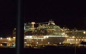
The deck lights used by cruise ships have been identified as a potential navigation risk at sea at night, in the investigation of a complaint by a yacht Skipper following an encounter with a cruise vessel, writes Tom MacSweeney.
It was investigated by the CHIRP Maritime organisation, the British (UK) Confidential Reporting Programme for Maritime incidents. The aim of CHIRP is to contribute to the enhancement of maritime safety worldwide. It says that it provides “a totally independent confidential (not anonymous) reporting system for all individuals employed in the maritime industry. It provides a similar aviation system.
The yacht Skipper reported to CHRIP that it was difficult to distinguish navigation lights amongst other deck lights:
“I was under sail in a Southerly direction when I saw the lights of another vessel off my starboard bow.” Endeavouring to keep clear “the relative tracks didn’t seem, to make sense if I was seeing what I thought was a green starboard navigation light.”
The vessel was a cruise ship which crossed a mile ahead, going from East to West.
“I should therefore, have been able to see the port navigation light, but could not convince myself there was a red light amongst the multitude of other lights visible on the cruise liner.”
As the vessels were both a safe distance from each other, there was no harm, but the amount of coloured lights on cruise ships has been identified as an issue needing attention.
The yacht Skipper said: “The Collision Regulations specify the minimum visibility of navigation lights. However, the impact of other bright lights, obscuring the navigation lights, is not appreciated. Vessels should ensure that their navigation lights are bright enough to be seen against the background of all their other lights and avoid using coloured deck lights where this can cause confusion. Very bright deck working lights obscuring navigation lights are often an issue on fishing boats as well.”
The CHIRP investigation comment said: “The Maritime Advisory Board highlighted the importance of taking a series of compass bearings in order to determine whether a risk of collision exists Navigation light visibility, irrespective of other lighting, must comply with COL REGS.
“They queried why classification societies permit these designs where visibility is obscured. Technology exists whereby deck lighting may be adequately shaded – permitting safe movement on board, yet not obscuring regulatory lights. The quality of lights bulbs used is another possible consideration. Take LED for example – are approved suppliers holding the introduction of these back due to a lack of any requirement in COLREGS?”


. He learned his sailing in the Royal Cork at Crosshaven but left Ireland (as did many others) in 1985 and is now so into America’s West Coast sailing scene that he owns a classic Cal 40")


 Michael Murphy Schull Harbour Sailing Club (SHSC), Eric Coogan Heineken Ireland, Mark Murphy, Commodore SHSC, Jack Allen SHSC, Carmel O'Regan SHSC, Cornelious Ndlovu, Schull Harbour Hotel Operations Manager and Derval Murphy SHSC")

