


Displaying items by tag: North Atlantic
Irish Research Marine Glider Deployed In North Atlantic On New Project
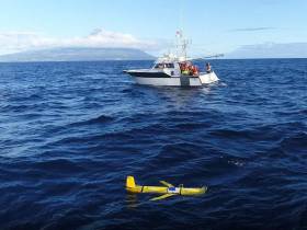
The Marine Institute’s marine glider has been deployed in the North Atlantic as part of a deep ocean marine science research project.
Laochra na Mara can reach depths of 1,000m and collects oceanographic data on conductivity, temperature, depth, fluorescence, turbidity and dissolved oxygen.
The glider was deployed from the RV Águas Vivas as part of the fifth project meeting for the Innovation in the Framework of the Atlantic Deep Ocean (iFADO) project recently held in The Azores, Portugal.
Prior to deployment, the glider was exhibited to the public at the Horta Maritime Terminal where local school students met iFADO team members and viewed several videos about glider operations and missions.
The school students also wrote messages on the glider before it was launched.
“Equipped with a wide variety of sensors, the glider can gather information about ocean temperature, salinity and currents, and transmits this information to shore via satellite,” Thomas Dabrowski of the Marine Institute said.
“Gliders are able to provide real-time data, and provide a better assessment and understanding of our ocean environment.”
Gliders are programmed to surface at designated times and transmit the data collected while at the same time downloading new mission instructions. This two-way communication allows gliders to continually gather information about the most important and diverse regions of our ocean basins 24 hours a day.
Similar to a glider from the United States that was found off Baltimore in 2017, the Slocum glider was recently recovered in the North Atlantic Ocean after 15 days at sea — during which it covered over 250km and performed over 40 deep dives.
The fifth iFADO project meeting gathered 50 participants and partner leads to hear the latest results and discuss future co-operation and follow-up action.
The iFADO project aims to create marine services at regional and sub-regional scale using the EU’s Atlantic waters as a case study. It combines traditional monitoring with cost-effective state-of-the-art technologies such as remote sensing, numerical modelling and emerging observation platforms such as gliders and oceanic buoys.
The Marine Institute is one of 20 partners from Ireland, the UK, France, Portugal and Spain involved in the iFADO project. The project has received funding from the European Union’s Interreg Atlantic Area Programme.
#Fishing - Sean Kyne TD, Minister with responsibility for the inland fisheries sector, today (Thursday 21 June) welcomed the positive outcome from the international discussions at the North Atlantic Salmon Conservation Organisation (NASCO) annual meeting in Portland, Maine, USA.
“Our departmental officials and those of Inland Fisheries Ireland represented Ireland at the negotiations as part of the EU delegation,” Minister Kyne said. “They joined delegates from the EU, USA, Canada, Norway, the Russian Federation, Greenland and the Faroes.
“The outcome of the week-long discussions is that, for the period 2019-2022, no harvest fishery will take place off the Faroe Islands and the restrictions on the fishery off West Greenland have been strengthened.
“I am pleased that these two important regulatory measures were agreed in a spirit of international c-ooperation.”
Minister Kyne emphasised the importance of these measures for Irish salmon migrating to distant feeding grounds before returning to their natal rivers in adulthood to spawn.
“The migratory stock complex travelling through Faroese waters comprises a majority component of European river stocks, including those from Ireland, and the measure to have no commercial fishing in these waters is important for these vulnerable stocks,” he said.
“I am particularly pleased that the discussions on the Faroes area were chaired by Ireland, on behalf of the EU.”
The majority component of the stock complex migrating to Greenlandic waters originates from the North American continent, and the restriction on fishing in this area assists these stocks as well as the smaller European component.
The agreed level of potential catch, for the internal use fishery in Greenland, is reduced by some 33% over the quota set in each of the last three years. Agreement was also reached on increased monitoring and control of the fishery.
The NASCO meeting also considered the factors that affect the marine survival of Atlantic salmon, with scientists, including those from IFI, engaged in cutting edge work to identify and address those causes.
Determining why salmon are dying at sea before they can come back to their natal rivers to spawn is a key research priority.
A new innovative approach to oceanic long range acoustic monitoring, ‘ROAM’ (RAFOS Ocean Acoustic Monitoring), will allow salmon to be tracked through the marine environment. The approach is intended to overcome many of the significant challenges associated with tracking Atlantic salmon throughout their extensive marine migration.
Minister Kyne concluded that the measures taken in Ireland, over a decade ago, to protect migratory salmon stocks have pointed the way internationally and the latest agreements at NASCO demonstrate restraints on exploiting Irish and other stocks as they migrate outside our waters.
Unmanned Research Boat Spotted Off Kerry Coast
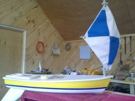
#Unmanned - A miniature unmanned sailing boat has been reported off the Kerry coast after nearly three years in the North Atlantic.
The boat, named West, is part of the Educational Passages project by the Middle School of Westbrook in Maine, USA and is one of five boats the Sebago School Alliance sent out in the autumn and winter of 2013-14.
West was launched off Georges Bank along with one other boat by Bro Cote, a lobsterman out of Hyannis, Massachusetts. Several others were launched about the same time off the Mid-East coast of the United States and off the Canary Islands for the marine science project.
“We had hoped the boat would make the complete circle of the Atlantic Ocean. It has and then some,” say the project organsiers about West, which has been spotted 32 nautical miles from the Kerry coastline.
West could arrive in the Kerry area over the next few days or, depending upon weather conditions, may go further northwards towards the Galway coast.
Previously West made landfall in November 2014 when it crashed on rocks in rough seas off Portugal, where it was recovered by local authorities and repaired with the help of local companies and relaunched from Lisbon in June last year.
Four months later, it was recovered entering the Mediterranean, refurbished again and put on a cargo ship to Madeira and relaunched from there on 28 January this year.
The project co-ordinators have asked for assistance to help rescue the boat when it arrives in the coming days
“It would be great if the boat could be recovered at sea or shortly after landing to avoid damage."
Transatlantic Seabed Mapping Survey Now Under Way
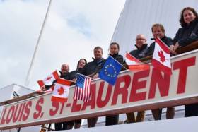
#SeabedMapping - The Atlantic Ocean Research Alliance's fifth transatlantic seabed mapping survey launched last Friday 22 July from eastern Canada.
Sailing on the Canadian Coast Guard Ship Louis S St-Laurent, the team will map the seafloor across the North Atlantic between Halifax in Nova Scotia and Tromso in Norway till next Tuesday 2 August.
The marine science team led by Paola Travaglini of Fisheries and Oceans Canada's Hydrographic Service are using state-of-the-art deep-water multibeam sonar technology to survey the seabed and study the physical characteristics of the seafloor, as well as other oceanographic data such as temperature and salinity, to better understand little-known areas of the North Atlantic and build on the work done last summer.
These surveys support the Galway Statement on Atlantic Ocean Co-operation, the goals of which are to join resources of its three signatories to better understand the North Atlantic, to promote sustainable management of its resources, and to promote citizens' understanding of the Atlantic through ocean literacy.
Participants in the survey include Fisheries and Oceans Canada's Hydrographic Service, the University of New Hampshire's Center for Coastal and Ocean Mapping Joint Hydrographic Center, and the Fisheries and Marine Institute of Memorial University of Newfoundland.
Students and early-career scientists representing Canada and the United States sailing on board the CCGS Louis S St-Laurent are writing daily blog posts to chronicle the mission. The team comprises:
- David Thornhill, Hydrographer, Fisheries and Oceans Canada Canadian Hydrographer Service
- Danielle Roche, Marine Institute of Memorial University of Newfoundland
- Darren Hiltz, Hydrographer, Fisheries and Oceans Canada Canadian Hydrographer Service
- Elizabeth Weindren, University of New Hampshire's Center for Coastal and Ocean Mapping Joint Hydrographic Center Fisheries
- Chris Hemmingway, National Director of UNCLOS, Fisheries and Oceans Canada Canadian Hydrographer Service
- David Levy, Electrical Technician, Fisheries and Oceans Canada Canadian Hydrographer Service
- Paola Travaglini, Hydrographer–In–Charge, Fisheries and Oceans Canada Canadian Hydrographer Service
Seabed mapping was one of the ocean research priorities and challenged discussed by the Marine Institute's CEO Dr Peter Heffernan with other heads of European marine science institutes in Ostend earlier this month, which followed a previous consultation that identified such mapping as crucial for managing human activities in our seas.
#PublicLecture - 'The Little Ice Age and the North Atlantic Fish Revolution' is the title of a public lecture delivered by Prof Poul Holm and Dr Francis Ludlow of Trinity College Dublin at lunchtime this Wednesday 13 April at the Marine Institute headquarters in Oranmore, Co Galway.
Holm is Professor of Environmental History at the School of Histories and Humanities in TCD. In 2015 he was awarded an Advanced Grant of €2.5 million by the European Research Council. In the next five years he and his team will explore the North Atlantic 'fish revolution' circa 1400-1700 AD.
In 1497, John Cabot returned to Bristol from a voyage across the North Atlantic. He told of waters so thick with fish that they could be lifted straight on board in baskets. Within a few years of this journey, fishermen from all over Western Europe made the journey across. This was the beginning of the 'fish revolution' of the early-modern world.
The fish revolution was one of the first examples of the disrupting effects of globalisation and climate change. Fish was a high-priced, limited resource in the Late Middle Ages. The Grand Banks fishery offered abundant high-quality low-priced catches to the European market. At the same time climate worsened as the Little Ice Age drove down sea temperatures and changed marine ecosystems.
The consequences were dire for fishermen along the coasts from the Irish Sea right up to northern Norway. As they caught less cod locally at higher prices, the fishermen had the choice of migrating across the ocean or give up fishing. Many fishing settlements were deserted as inhabitants took to the road to seek casual work in agriculture or towns.
Kings and high politics were similarly affected by the fish revolution. The new resource held strategic importance for all major western European powers, such as Spain, Britain and France. North Atlantic warfare was about fish as well as about gold.
In recent years we have all been affected by the impact of global change. We want to know if we can untangle the drivers of prices and temperatures to explain the causes of the fish revolution, and we want to know how people understood and responded to the challenges of globalisation and climate change. The lecture posits that perhaps the fish revolution of the Middle Ages is a distant mirror for today.
All are welcome to the event at the Marine Institute Auditorium this Wednesday at 12 noon.
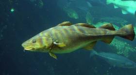
Rockall Fishing Ban Recommended After New Marine Discoveries
#MarineWildlife - The Guardian reports that fishing is expected to be banned near Rockall after the recent discovery of a rare ocean floor gas vent and new species of shellfish.
The 'cold seep' methane vent found by Scotland-based marine scientists last year is only the third of its kind to be found in this region of the Atlantic Ocean - and apparently has a 'chemosynthetic' relationship with two species of deep-water clam, and the polychaete worms they contain, that are new to science.
Also found was a frilled shark, described as a 'living fossil' for existing as a species for at least 90 million years. Such sharks are seldom seen north of the tropics.
In the wake of these findings, the International Convention on the Exploration of the Seas has recommended a ban on fishing activity at the site and its surrounds.
Rockall - which adventurer Nick Hancock is attempting to occupy for a world record attempt - is a tiny rocky islet north-east of Donegal, almost halfway between Ireland and Iceland in the North Atlantic. It has long been the subject of territorial dispute, with Ireland, the UK, Iceland and Denmark all staking a claim.
The Guardian has much more on the story HERE.
Drogheda Hosts North Atlantic Salmon Conference
#Fishing - Drogheda is hosting the 30th annual meeting of the North Atlantic Salmon Conservation Organisation (NASCO) this week till Friday 7 June.
The prestigious fisheries conference will take place in the Westcourt Hotel and will be attended by delegates from Canada, Denmark (in respect of the Faroe Islands and Greenland), the European Union (representing its 27 member states), Norway, Russia and the USA.
Welcoming the conference to Drogheda on Tuesday 4 June, Minister Fergus O’Dowd said it "will continue the key work of NASCO, using the best scientific information, and international co-operation to conserve and manage Atlantic salmon populations.
"I wish the many delegates a friendly and intellectually stimulating stay in Drogheda where the meeting programme will no doubt provide insights and an outstanding platform for dynamic networking to ensure the continued conservation of our precious salmon stocks."
Based in Edinburgh, NASCO is an international organisation established by an intergovernmental convention in 1984. Its main function is to conserve, restore, enhance and rationally manage Atlantic salmon through international cooperation taking account of the best available scientific information.
NASCO is the only intergovernmental organisation with this mandate, which it implements through international consultation, negotiation and co-operation.
Ireland is at the forefront of salmon conservation internationally, according to Inland Fisheries Ireland, which adds that Irish participants at the conference include a Government delegation of managers and scientists and representatives of a number of Irish-based NGOs, including Salmon Watch Ireland.
The cross-border Loughs Agency, which has responsibility for salmon conservation and protection Foyle and Carlingford Loughs, will also be represented as part of the Irish delegation.
Titanic Emergency as Ill Passenger Airlifted
#TITANIC - The Titanic memorial cruise was yesterday forced to turn back just 100 miles from the southwest coast of Ireland after a passenger fell ill, BBC News reports.
The Irish Coast Guard rescue helicopter at Shannon was dispached to the MS Balmoral to retrieve BBC cameraman Tim Rex, 56, who was struck by a non-life threatening heart condition, according to the Irish Independent.
Rex, who was covering the memorial sailing for the BBC, was treated by ship's doctors before being airlifted to hospital as a precaution.
The emergency happened just hours after the ship departed Cobh, the last port of call of the ill-fated Titanic before it sank in the North Atlantic on 14 April 1912.
A spokesperson for Titanic Memorial Cruises confirmed that despite the delay, the ship is still on schedule and is expected to arrive at the Titanic wreck site as planned on Saturday.
Titanic As She's Never Been Seen Before

#TITANIC - Next month's edition of National Geographic magazine features startling images with the first ever complete views of the wreck of the Titanic.
The large-scale panoramas were produced by combining "thousands of high-resolution images" of the wreck on the North Atlantic sea floor, according to the Guardian - which has a sample gallery of the Titanic as it is today HERE.
Al Mennie's Epic Charity Paddle from Giant's Causeway
#SURFING - Northern Irish surf pro Al Mennie will be taking on a different challenge later this month, when he sets out to paddle a surfboard from the Giant's Causeway to Scotland in the name of charity.
"It will be the northernmost crossing of its type in the world," says Mennie of the 25-mile route from Antrim to the Scottish island of Islay.
"I will have to deal with freezing cold temperatures, large open ocean swell, potentially high winds and the deadly currents around a well known navigational hazard of a North Atlantic island."
Mennie will be on his own except for a support boat carrying food and water. He will be wearing a 6mm wetsuit and crossing the most dangerous stretch of water around the Irish coastline, "known for its extremely deadly currents as the Irish Sea tides drain between Rathlin Island and Northern Ireland".
The NI surfer is embarking on the challenge in aid of Northern Ireland Chest Heart and Stroke, which is a charity close to his own heart.
"My dad died suddenly of a heart attack aged 50 and I know lots of people who have also lost loved ones to heart problems too," he says, "so I really want to help make a difference by raising money for this charity."
For more details or to make a donation, visit the charity page at Al Mennie's website HERE.


 linking Spain.")


 Michael Murphy Schull Harbour Sailing Club (SHSC), Eric Coogan Heineken Ireland, Mark Murphy, Commodore SHSC, Jack Allen SHSC, Carmel O'Regan SHSC, Cornelious Ndlovu, Schull Harbour Hotel Operations Manager and Derval Murphy SHSC")


