


Displaying items by tag: Providence Resources
Marine Notice: Multibeam & Side-Scan Sonar Survey Off South Coast
The Department of Transport advises that an analogue survey consisting of multibeam, side-scan sonar and magnetometer will be carried out off the South Coast of Ireland by the Marine Institute on behalf of Providence Resources from Saturday 23 to Sunday 31 October, weather permitting.
In addition to the analogue survey, seabed samples and camera imagery will be acquired at approximately 10 stations in the survey area.
The survey will be conducted in Block 48/24 Barryroe, in the North Celtic Basin, around 45–50km from the south coast of Ireland, and will be undertaken by the RV Celtic Voyager (callsign EIQN). The vessel will be towing a side-scan sonar and magnetometer from time to time with cables of up to 300m long.
As this vessel will be restricted in its ability to manoeuvre when surveying, other vessels are requested to keep a wide berth. The vessel will display appropriate lights and signals.
For details of coordinates of the survey area, see Marine Notice No 55 of 2021 which is available to download below.
Marine Notice: Surveys Off South & South West Coasts
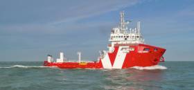
#MarineNotice - The survey vessel VOS Sweet (Callsign PCPE) is currently conducting offshore geotechnical and environmental survey operations associated with the proposed Celtic Interconnector on behalf of EirGrid.
The VOS Sweet was set to commence operations yesterday, Monday 18 June, and will operate on a 24-hour daily basis for approximately two weeks in two main corridors off East Cork to three landfall points: Ballinwilling Strand (Ballycotton Bay); Redbarn Beach and Claycastle Beach (Youghal Bay).
The survey is to collect geotechnical data utilising a Vibrocorer (VC) and Cone Penetration Test (CPT) spread and environmental (benthic) data utilising Grab Sampler spread. The survey will be conducted under Foreshore Licence FS006811. Common frequency VHF Channel 16 shall be used throughout the project.
Details of the route centreline co-ordinates as well as intended locations for the VC, CPT and benthic sampling are included in Marine Notice No 26 of 2018, a PDF of which is available to read or download HERE.
Meanwhile, Providence Resources is carrying out a site survey on its FEL 6/14 licence, called Newgrange, situated between the Southern Porcupine and Goban Spur Basins some 260km off the South West Coast.
The eight-day geophysical survey by the MV Kommandor (Callsign MCJO2), was scheduled to commence on Monday, is using dual-frequency side scan sonar, single-beam and multi‐beam echosounders, side scan sonar, sub‐bottom profilers and magnetometer.
Seabed (benthic) samples will also be taken using a box corer or grab as appropriate, and geotechnical sampling will be undertaken with a piston corer to a minimum target depth of 6m below the seabed.
In addition to the above, and to accurately determine potential future drilling hazards over the Newgrange location, the proposed survey will also include a high resolution 2D seismic which is not expected to exceed two days.
Survey operations will be conducted on a 24-hour basis. The MV Kommandor will be displaying shapes and lights prescribed in the International Rules for the Prevention of Collisions at Sea (COLREGS) Rule 27, to indicate that the survey vessel is restricted in its ability to manoeuvre. A listening watch will be maintained on VHF Channel 16, and the vessel will actively transmit an AIS signal.
Co-ordinates and a map of the expected working area are outlined in Marine Notice No 25 of 2018, a PDF of which is available to read or download HERE.

#MarineNotice - Providence Resources advises it intends to drill an exploration well in the Southern Porcupine Basin.
Operations were scheduled to begin today (Monday 3 July) to drill the well at a depth of 2,250 metres some 220km off the South West Coast of Ireland.
Drilling is expected to take 60 days to complete, subject to weather and operational delays.
The dynamically positioned drill ship Stena IceMax (Callsign 2FMJ5) will carry out the drilling, supported by platform supply vessels Sjoborg (Callsign OZ-2075), Edda Frende (Callsign LCOB) and Skandi Flora (Callsign LEVX). The emergency rapid response vessel is Esvagt Don (Callsign MZWQ6).
There will be a safety exclusion zone of 500m radius from the drill ship. Regular safety messages will be broadcast on VHF Channel 16 by Esvagt Don throughout the project. Radio navigation warnings will also be issued several times daily by the Irish Coast Guard.
All vessels, particularly those engaged in fishing, are requested to give the Stena IceMax and accompanying vessels a wide berth and keep a sharp lookout in the relevant areas.
Full details of the drilling area are included in Marine Notice No 28 of 2017, a PDF of which is available to read or download HERE.
Reduced Costs Drive Barryroe Oil Field Farm-Out Interest
#Oil&Gas - A drop in exploration costs alongside the fall in commodities prices is driving increased interest in Providence Resources' Barryroe prospect, as The Irish Times reports.
"Work continues with a number of parties to progress the Barryroe farm out to a satisfactory conclusion,” said Tony O’Reilly, chief executive of the Dublin-based oil and gas exploration firm.
It comes more than a year after negotiations over the farm-out of the oil field off Ireland's south coast began, a process that the company said was "taking much longer to achieve" due to unfavourable market conditions.
Studies in 2012 indicated that the Barryroe field could yield as much as 1.6 billion barrels, and be worth many billions to the Irish economy.
The Irish Times has more on the story HERE.
Providence Divesting Almost One-Third Of Spanish Point Interest
#Oil&Gas - Providence Resources is divesting almost a third of its interest in its Spanish Point prospect, as The Irish Times reports.
The Irish oil and gas exploration company intends to sell off a 32% "non-operated interest" in the area off the coast of Co Clare, in the northern part of the Porcupine Basin, which has been shown to hold enormous reserves of oil.
Providence delayed its own exploration at Spanish Point earlier this year due to "unforeseen changes" to its joint venture at the well.
But drilling is now expected to take place in 2017 pending State approval.
The Irish Times has more on the story HERE.
Spanish Point Drilling Delayed By Oil & Gas Exploration Firm

#Oil&Gas - Providence Resources has delayed exploration of its Spanish Point well off Co Clare "pending discussions with partners and the Government", as The Irish Times reports.
Already pushed back from last summer due to the longer-than-planned refurbishment of the Blackford Dolphin rig, the Spanish Point option - granted in January last year – was subsequently seismic surveyed for oil and gas condensate in the autumn.
The latest delay, however, comes after "recent unforeseen changes to the make-up of the joint venture".
That's according to Providence chief executive Tony O'Reilly, who adds that discussions with interested third parties for the prospect continue.
The Irish Times has more on the story HERE.
Providence Positive About Drombeg Prosect

#Oil&Gas - Providence Resources is talking positive about its Drombeg prospect off the south-west coast, as The Irish Times reports.
The site in the southern Porcupine Basin was surveyed last summer by the Polarcus Amani, said to be one of the greenest seismic vessels in the world, in what was one of the largest 3D seismic surveys yet carried out off Ireland.
And the preliminary results have revealed "seismic morphologies" that are "consistent with those of a large deep-water fan system".
What's more, the site has already "attracted expressions of interest from a number of major international oil companies," says Providence technical director John O'Sullivan.
The Irish Times has more on the story HERE.
Barryroe 'Main Priority' For Providence As Negotiations Reach 'Advanced Stage'

#Oil - Providence Resources says it is at "an advanced stage" in negotiations to farm out its Barryroe oil field prospect off Cork, as The Irish Times reports.
Commenting on the Irish energy company's half-year results released today, CEO Tony O'Reilly said the Barryroe project "remains our main priority" – with Providence aiming to return on its investment while retaining "a material stake" in the field, of which is owns 80%.
Last month, as reported on Afloat.ie, the company urged shareholders at its AGM to quell public speculation over any potential deal, which was "taking much longer to achieve" than previously expected.
The Irish Times has more on the story HERE.

#Oil - Providence Resources says it is "nearing completion" of its negotiations to secure a farm-out partner for its Barryroe prospect off the Cork coast, as The Irish Times reports.
Speaking at the Irish-based oil and gas company's AGM earlier this week, CEO Tony O'Reilly also urged interested parties to hold off on any public speculation over the deal, which chairman Brian Hillery said was "taking much longer to achieve" due to "the current environment".
"It's not a question of getting a deal, it's getting the right deal," he told shareholders. "Rest assured the farm-out remains the main priority of the company."
That wasn't enough to quell some shareholders' displeasure, however, with one taking Providence to task over the drastic fall in its share price over the last 12 months - in part a result of alleged setbacks to the south coast prospect in January.
The Irish Times has much more on the story HERE.
Providence Delays Spanish Point Appraisal Till 2015

#Oil - Delays in the refurbishing of the Blackford Dolphin oil rig have prompted Providence Resources to push back their appraisal drilling on Spanish Point till 2015, as Business & Leadership reports.
The Irish oil and gas firm was granted a new licensing option for the well some 160km off Spanish Point in Co Clare earlier this year, helping to put the company "in the leading position" in a zone that's rich in undersea hydrocarbons.
However, the Blackford Dolphin, which was scheduled to drill the well this summer, only recently left Belfast after a six-month refurbishment that was originally planned for just six weeks.
And the giant oil rig will no longer be headed for the Clare coast as planned, following the termination of Providence's contract with Dolphin.
With the delays meaning that drilling could not commence till October this year, Providence has chosen to postpone the project till next spring - and will also tender for another rig for the job.
Business & Leadership has more on the story HERE.


. He learned his sailing in the Royal Cork at Crosshaven but left Ireland (as did many others) in 1985 and is now so into America’s West Coast sailing scene that he owns a classic Cal 40")


 Michael Murphy Schull Harbour Sailing Club (SHSC), Eric Coogan Heineken Ireland, Mark Murphy, Commodore SHSC, Jack Allen SHSC, Carmel O'Regan SHSC, Cornelious Ndlovu, Schull Harbour Hotel Operations Manager and Derval Murphy SHSC")

