Menu

Ireland's sailing, boating & maritime magazine

Displaying items by tag: Sea Level

East Cork, Waterford, Galway and the Shannon Estuary will be the first to bear the brunt of an “alarming and startling” rise in sea levels, a TD has warned.

As the Irish Examiner reports, David Stanton (Cork East) expressed his fears of a “truly frightening” outcome for many coastal communities in the continued absence of a national coastal risk strategy.

“There is no point waiting until the seawater is up to our knees and then saying we should have planned for this 20 years ago,” he said.

The Irish Examiner has more on the story HERE.

Published in Coastal Notes
Tagged under

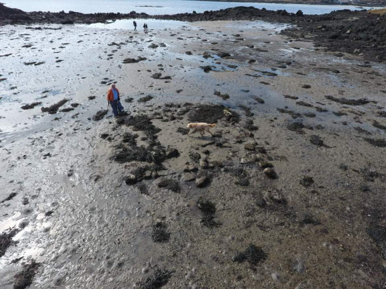
Discovery of the remains of a “drowned” prehistoric house in north Connemara may be further evidence of sea-level rise along the Atlantic coast in the last millennium.

As The Sunday Times reports today, parts of a small prehistoric dwelling covered by sea except at low spring tide have been identified by archaeologist Michael Gibbons and engineer Shane Joyce on the coast south-west of Clifden, Co Galway.

The site is in a sheltered “lagoon-like setting” on the tip of the Faul peninsula, at the junction of Clifden and Ardbear bays.

Gibbons said that the structure is similar in size to early Neolithic houses, and it is protected from tidal surges by Oileán Gearr or Islandagar, a small island on its western side.

Gibbons said it was further evidence of a “drowned prehistoric landscape”, which has been researched and dated by NUI Galway palaeoecologists Prof Michael O’Connell and Dr Karen Molloy.

O’Connell and Molloy have estimated that sea levels rose by as much as four metres on the Atlantic coast in later prehistory - as in 1,000 years ago – with Galway Bay being younger than originally estimated.

Prof O’Connell said that it was “quite reasonable” to suggest the structure identified by Gibbons and Joyce may be early Neolithic, given that sea level rise occurred in the late Neolithic period.

O’Connell and Molloy’s work focused on tree stumps, believed to be bog pine, which have been exposed at low tide by storms dating back to 2010, along with pollen analysis of coastal peat deposits.

Gibbons said that a shell midden dating from 4,000 BC on the Errislannan peninsula, just south-west of the Faul location, was also evidence of Neolithic settlement by early farmers.

Read The Sunday Times report here

Published in Coastal Notes
Tagged under

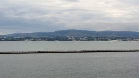
Dublin Bay’s sea level seems to be rising faster than forecast — and at twice the global average over the past two decades.

The Irish Times reports on this startling claim from Dun Laoghaire-Rathdown County Council’s (DLRCoCo) climate change action plan, which also notes that weather extremes are “likely to increase in their frequency and intensity”.

The report comes following one of Ireland’s hottest summers on record, itself just months after a first ever Status Red warning for snow was issued by Met Éireann.

Three Dublin local authorities launched their climate action plans on Monday (9 September), with DLRCoCo’s plan pledging to “prioritise nature-based flood defences where possible” over the next five years.

The Irish Times has much more on the story HERE.

Published in Dublin Bay

About Dublin Port 

Dublin Port is Ireland’s largest and busiest port with approximately 17,000 vessel movements per year. As well as being the country’s largest port, Dublin Port has the highest rate of growth and, in the seven years to 2019, total cargo volumes grew by 36.1%.

The vision of Dublin Port Company is to have the required capacity to service the needs of its customers and the wider economy safely, efficiently and sustainably. Dublin Port will integrate with the City by enhancing the natural and built environments. The Port is being developed in line with Masterplan 2040.

Dublin Port Company is currently investing about €277 million on its Alexandra Basin Redevelopment (ABR), which is due to be complete by 2021. The redevelopment will improve the port's capacity for large ships by deepening and lengthening 3km of its 7km of berths. The ABR is part of a €1bn capital programme up to 2028, which will also include initial work on the Dublin Port’s MP2 Project - a major capital development project proposal for works within the existing port lands in the northeastern part of the port.

Dublin Port has also recently secured planning approval for the development of the next phase of its inland port near Dublin Airport. The latest stage of the inland port will include a site with the capacity to store more than 2,000 shipping containers and infrastructures such as an ESB substation, an office building and gantry crane.

Dublin Port Company recently submitted a planning application for a €320 million project that aims to provide significant additional capacity at the facility within the port in order to cope with increases in trade up to 2040. The scheme will see a new roll-on/roll-off jetty built to handle ferries of up to 240 metres in length, as well as the redevelopment of an oil berth into a deep-water container berth.

Dublin Port FAQ

Dublin was little more than a monastic settlement until the Norse invasion in the 8th and 9th centuries when they selected the Liffey Estuary as their point of entry to the country as it provided relatively easy access to the central plains of Ireland. Trading with England and Europe followed which required port facilities, so the development of Dublin Port is inextricably linked to the development of Dublin City, so it is fair to say the origins of the Port go back over one thousand years. As a result, the modern organisation Dublin Port has a long and remarkable history, dating back over 300 years from 1707.

The original Port of Dublin was situated upriver, a few miles from its current location near the modern Civic Offices at Wood Quay and close to Christchurch Cathedral. The Port remained close to that area until the new Custom House opened in the 1790s. In medieval times Dublin shipped cattle hides to Britain and the continent, and the returning ships carried wine, pottery and other goods.

510 acres. The modern Dublin Port is located either side of the River Liffey, out to its mouth. On the north side of the river, the central part (205 hectares or 510 acres) of the Port lies at the end of East Wall and North Wall, from Alexandra Quay.

Dublin Port Company is a State-owned commercial company responsible for operating and developing Dublin Port.

Dublin Port Company is a self-financing, and profitable private limited company wholly-owned by the State, whose business is to manage Dublin Port, Ireland's premier Port. Established as a corporate entity in 1997, Dublin Port Company is responsible for the management, control, operation and development of the Port.

Captain William Bligh (of Mutiny of the Bounty fame) was a visitor to Dublin in 1800, and his visit to the capital had a lasting effect on the Port. Bligh's study of the currents in Dublin Bay provided the basis for the construction of the North Wall. This undertaking led to the growth of Bull Island to its present size.

Yes. Dublin Port is the largest freight and passenger port in Ireland. It handles almost 50% of all trade in the Republic of Ireland.

All cargo handling activities being carried out by private sector companies operating in intensely competitive markets within the Port. Dublin Port Company provides world-class facilities, services, accommodation and lands in the harbour for ships, goods and passengers.

Eamonn O'Reilly is the Dublin Port Chief Executive.

Capt. Michael McKenna is the Dublin Port Harbour Master

In 2019, 1,949,229 people came through the Port.

In 2019, there were 158 cruise liner visits.

In 2019, 9.4 million gross tonnes of exports were handled by Dublin Port.

In 2019, there were 7,898 ship arrivals.

In 2019, there was a gross tonnage of 38.1 million.

In 2019, there were 559,506 tourist vehicles.

There were 98,897 lorries in 2019

Boats can navigate the River Liffey into Dublin by using the navigational guidelines. Find the guidelines on this page here.

VHF channel 12. Commercial vessels using Dublin Port or Dun Laoghaire Port typically have a qualified pilot or certified master with proven local knowledge on board. They "listen out" on VHF channel 12 when in Dublin Port's jurisdiction.

A Dublin Bay webcam showing the south of the Bay at Dun Laoghaire and a distant view of Dublin Port Shipping is here
Dublin Port is creating a distributed museum on its lands in Dublin City.
 A Liffey Tolka Project cycle and pedestrian way is the key to link the elements of this distributed museum together.  The distributed museum starts at the Diving Bell and, over the course of 6.3km, will give Dubliners a real sense of the City, the Port and the Bay.  For visitors, it will be a unique eye-opening stroll and vista through and alongside one of Europe’s busiest ports:  Diving Bell along Sir John Rogerson’s Quay over the Samuel Beckett Bridge, past the Scherzer Bridge and down the North Wall Quay campshire to Berth 18 - 1.2 km.   Liffey Tolka Project - Tree-lined pedestrian and cycle route between the River Liffey and the Tolka Estuary - 1.4 km with a 300-metre spur along Alexandra Road to The Pumphouse (to be completed by Q1 2021) and another 200 metres to The Flour Mill.   Tolka Estuary Greenway - Construction of Phase 1 (1.9 km) starts in December 2020 and will be completed by Spring 2022.  Phase 2 (1.3 km) will be delivered within the following five years.  The Pumphouse is a heritage zone being created as part of the Alexandra Basin Redevelopment Project.  The first phase of 1.6 acres will be completed in early 2021 and will include historical port equipment and buildings and a large open space for exhibitions and performances.  It will be expanded in a subsequent phase to incorporate the Victorian Graving Dock No. 1 which will be excavated and revealed. 
 The largest component of the distributed museum will be The Flour Mill.  This involves the redevelopment of the former Odlums Flour Mill on Alexandra Road based on a masterplan completed by Grafton Architects to provide a mix of port operational uses, a National Maritime Archive, two 300 seat performance venues, working and studio spaces for artists and exhibition spaces.   The Flour Mill will be developed in stages over the remaining twenty years of Masterplan 2040 alongside major port infrastructure projects.

Source: Dublin Port Company ©Afloat 2020.