


Displaying items by tag: Slyne Head
Clifden Lifeboat Rescues Fisherman Off Slyne Head
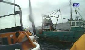
#RNLI - Clifden RNLI’s all-weather Mersey Class lifeboat Fisherman's Friend was launched at 1.30pm on Saturday (1 July) to go to the assistance of a fishing vessel adrift six miles off Slyne Head in Co Galway.
The 11m vessel had been en route from Baltimore to Blacksod before it suffered engine problems in challenging weather conditions, with a 2m swell and Force 6 wind blowing from the north west.
The skipper requested some water to try and get his engine going again. The lifeboat crew assisted, and this initially solved the problem. However, the engine soon stalled again, and the lifeboat crew proceeded to establish a towline.
At 3.30pm the vessel was put under tow and returned to Clifden Bay. The tow took just over two hours to complete.
Speaking following the callout, coxswain John Mullen said: “We dropped the skipper off on the visitor’s moorings in Clifden Bay with the assistance of the inshore D Class lifeboat.
“It was a good call out for the all-weather lifeboat in challenging conditions. We would like to wish the fisherman well and thank all the crew involved.”
Weather Warning for Irish Sea as Winter Winds Sweep In
#WEATHER - Met Éireann has issued a weather warning for the Irish Sea for the next 24 hours due to expected gale force westery winds.
A small craft warning has also been issued, with west to southwest winds continuing to reach force 6 tonight on the Irish coast from Carlingford Lough to Roches Point to Slyne Head.
The high winds marks the first wave of real winter weather after a milder-than-average November, the Evening Herald reports.
A forecaster told the paper that strong winds have "reached storm force on the Irish coasts from Belfast Lough to Wicklow Head to Mizen Head and on the Irish Sea.
"We expect that by tonight they will slightly drop but may still reach a strong gale force."
Where to Sail in the West of Ireland
Where to Sail in the West of Ireland
Shannon Estuary – and from Dingle to Slyne Head
At over 100 kilometres long, the Shannon estuary stretches from the western edge of Ireland at Loop Head to east of Limerick city and beyond.
No other waterway brings so much to Irish lives: up to 40% of our energy supplies; Ireland’s second-largest airport; it’s second-largest cargo port; a 10,000 student university – all on the banks of the estuary.
The Shannon Scheme has been bringing electricity to tens of thousands of homes for over 75 years; long before ‘Green Energy’ was heard of in Ireland. This massive award-winning hydroelectric project, producing 85 megawatts of power, was one of the most important building projects ever undertaken in Ireland.
However, it’s not only the ferries and hydroelectric power that are benefiting from the estuary – it seems that all around its banks, people are turning back to face its waters. Limerick’s Riverside City project, initiated during the Celtic Tiger, has helped bring Limerick back to the water.
Four rowing clubs from the city have made this area a main centre for their sport in the country; Kilrush’s development is also encouraging to those who wish to spend time on the water; and Shannon Airport sees approximately three million people pass through its gates on up to 26,000 flights – a forcus for tourism, business and employment since 1946.
The estuary itself, the only one big enough to accommodate Capesize ships (too large for the Suez or Panama Canals), is not only a driving force behind Ireland’s economy but home to the Shannon Dolphin Foundation which allows tourists and locals to dip into that environment from Carraigahold pier. On the Kerry side, Ballybunion’s lush golf links (established in 1893) have entertained up to 100,000 golfing tourists each year.
Limerick city, because of it’s strategic placing, owes it’s origins to the Shannon waters, as from there, smaller boats could access the heart of Ireland while the estuary opened up trade foutes into Europe and beyond. The history of what became known as King John’s Castle is long and fascinating, and Bunratty Castle, built around 1425 a few miles downriver, can attract up to 350,000 visitors each year.
The clutch of islands in the middle of the Fergus estuary – Canon Island, Coney Island, Horse Island and Scattery – were once home to a vibrant, bilingual community fishing and farming around the estuary. Scattery was first used as a monastery site in the sixth century, though the monastery didn’t survive Elizabethan times and it’s population declined steadily after 1881. Because of it’s isolation, the monastery founder St. Senan thought it ideal for his needs – legend has it it forbade any woman to live or land on the island.
Kilrush in Co. Clare is where island residents moved to – making the short journey across the estuary to what once was a small market town but is now the estuary’s marine leisure centre. It’s here that most people learn how to sail on the waterway, as the marina is home to an adventure centre and the area’s largest fleet of racing yachts. So popular is this marina that plans have had to be drawn up to double it’s capacity.
Sailing has a long and proud tradition in these parts: Ger O’Rourke and his yacht Chieftain emerged from these shores, as has Conor O’Brien (left from Foynes in 1923, the first amateur skipper to sail a yacht around the world); and the Knight of Glin who starts the September race.
Brandon Bay, on the north side of the Dingle peninsula, is completely open to the north but reasonably sheltered from the south-east through south-west to north-west. A decent pub with a good bar overlooking the bay provides victuals and refreshment when needed. Mutton Island has sheltered anchorage though no facilities. Kinvarra, small and sheltered, requires some careful pilotage but is good for provisioning. If you make your way to Galway you can enjoy the beautiful city – recent stopover point for the Volvo Ocean Race – with it’s pedestrianised centre. Galway’s sailing club is at Rinville – they may have moorings available though you’d be three miles from any facilities.
Aran Islands – the three: Inishsheer, Inishmaan and Inishmore – are made of limestone and of varied geology. Inishmore is the largest with a secure and sheltered harbour at Kilronan, ferries from the mainland, a supermarket, some restaurants and bars and bicycle hire at the quay. The ancient ford of Dun Aengus is worth a visit: dating from approx. 800BC, it was built as a deterrant to invaders and it’s vast semi-circular structure is quite impressive. The two smaller islands – Inisheer and Inishmaan – do not have safe anchorages.
Continuing up the coast there’s the Greatman and Kiggaul bays – small and requiring a delicate touch if mooring; and St Macdara’s Island at the entrance to Roundstone. Less than half a mile across, it boasts one of the earliest of European churches – a tiny monastery dating from the 6th century. Roundstone itself is a pretty village with shops and restaurants – worth a visit.
From Kinsale to Dingle
It’s generally accepted that the scenery is stunning: rolling hills, coastal cliffs, and substantial mountains. There’s three large inlets which provide havens no matter the wind direction: Dunmanus Bay, Bantry Bay and the Kenmare River. There’s also a mass of islands, lyrically named Roaring Water Bay, which would provide days of sailing experience. With prevailing south-westerly winds, the weather can change rapidly but is normally warm because of the Gulf Stream. Of course, this being Ireland, you could leave port early in the rain but by lunchtime be basking in the sunshine. Excellent Coast Guard radio stations will keep you appraised of changes in weather patterns.


 LÉ Aoibhinn and LÉ Gobnait at the Naval Service Base at Haulbowline, Cork Harbour. They are to carry out fishery duties, etc on the Irish Sea, east and south-east.")


