Menu

Ireland's sailing, boating & maritime magazine

Displaying items by tag: Storm Eunice

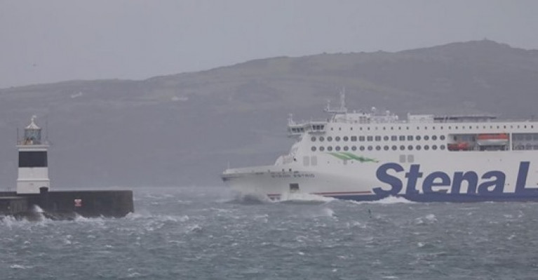
Several ferry crossings and flights have been cancelled as Storm Eunice tracks across Ireland.

Gusts of more than 130km/h have been reported in some areas, and thousands of homes and businesses have been left without power.

(For more on coverage of flights see also the RTE News report)

A number of ferry sailings to the UK, France and Spain from Rosslare have also been cancelled. All intending ferry and air passengers are advised to check what is going ahead with whoever they are booked with.

ESB Networks has said that 80,000 customers are now without power nationally.

In addition to read more on the weather situation nationwide click here

Published in Ferry

Dublin Port Company will temporarily close access to both the Great South Wall and the Bull Wall bridge tomorrow (Friday 18 February) due to the arrival of Storm Eunice.

The Great South Wall wall be closed from midnight tonight until 7am on Saturday, while bridge access to the Bull Wall will be closed from 10am to 4pm tomorrow.

These times will be subject to review and adjustment as necessary over the next 24 hours, the port company says.

Meanwhile, Met Éireann has upgraded its warnings for Storm Eunice as it tracks inland this evening.

A Status Red storm warning is now in place from Howth Head to Roches Point to Erris Head and on the Irish Sea south of Anglesey, as cyclonic variable winds veering northwesterly will reach storm force 10 or violent storm force 11 at times overnight and tomorrow morning.

There will also be a risk of coastal flooding, especially at high tide, in counties Clare, Kerry, Cork and Waterford.

For the latest updates visit Met.ie.

Published in Weather
Tagged under

With both Met Éireann and the UK’s Met Office predicting disruptive weather this week due to back-to-back storms, the RNLI has urged the public to be careful at the coast.

The charity that saves lives at sea is encouraging people to exercise extreme caution if visiting the shoreline, especially along exposed cliffs, seafronts and piers with winds expected to hit 145kmh.

Storm Dudley is due to affect Ireland, Scotland, Northern Ireland and parts of northern England tomorrow afternoon (Wednesday 16 February), with Storm Eunice close behind and bringing a weather warning for most of Ireland and the UK on Friday.

RNLI national water safety partner Samantha Hughes said: “The expected storms could make our seas treacherous, increasing the risk for those visiting the coast around the UK and Ireland.

“In a normal year around, 150 people lose their lives at the coast and we know that more than half of those never intended to be in the water. So, whether you are walking, running or cycling at the coast, please be extra responsible and avoid taking unnecessary risk or entering the water.

“In particular, we ask people to stay well back from stormy, wintery seas and cliff edges, check tide times before you go, take a phone with you, and call 999 or 112 and ask for the coastguard if you or someone else is in trouble.”

Met Éireann meteorologist Liz Coleman said: “Whilst Wednesday will be a windy and gusty day everywhere, the winds will be especially strong in hilly areas and along exposed coasts where we could have gusts reaching 80-110kmh at times. The strong winds in combination with high tides could lead to large coastal waves and some coastal flooding in parts of the west and northwest.”

She added: “Storm Eunice will quickly develop in the Atlantic on Thursday and arrive on our shores on Thursday evening. This system will bring strong winds, spells of heavy rain and snow on Thursday night, leading to multiple hazards and the potential for damage and disruption to travel, especially on Friday morning.

“A Weather Advisory is in place for Thursday night and Friday and current indications suggest the strongest winds are likely to be across the southern half of the country, with the most significant snowfalls over central and northern parts of the country. Further heavy rainfall may lead to river and spot flooding in parts of the north west. Weather warnings are likely to be issued in the coming day, so we’re advising people to keep a close eye on the forecast and warnings.”

A Small Craft warning is in place from this evening (Tuesday 15 February) for all coasts of Ireland, with westerly winds reaching Force 6.

In addition, a Status Yellow gale warning is in place from Valentia to Erris Head to Fair Head as west to southwest winds are forecast to reach Force 8 this evening and Force 9 overnight. The warning extends to all coasts of Ireland and the Irish Sea from tomorrow morning.

The RNLI’s key water safety advice is:

  • Take care if walking near cliffs – be aware of ice and frost, know your route and keep dogs on a lead.
  • Check weather forecasts and tide times daily.
  • Take a fully charged phone.
  • Check your equipment is in good working order.
  • Be aware of the conditions and your capabilities.
  • In an emergency call 999 or 112 and ask for the coastguard.
Published in Water Safety

About Dublin Port 

Dublin Port is Ireland’s largest and busiest port with approximately 17,000 vessel movements per year. As well as being the country’s largest port, Dublin Port has the highest rate of growth and, in the seven years to 2019, total cargo volumes grew by 36.1%.

The vision of Dublin Port Company is to have the required capacity to service the needs of its customers and the wider economy safely, efficiently and sustainably. Dublin Port will integrate with the City by enhancing the natural and built environments. The Port is being developed in line with Masterplan 2040.

Dublin Port Company is currently investing about €277 million on its Alexandra Basin Redevelopment (ABR), which is due to be complete by 2021. The redevelopment will improve the port's capacity for large ships by deepening and lengthening 3km of its 7km of berths. The ABR is part of a €1bn capital programme up to 2028, which will also include initial work on the Dublin Port’s MP2 Project - a major capital development project proposal for works within the existing port lands in the northeastern part of the port.

Dublin Port has also recently secured planning approval for the development of the next phase of its inland port near Dublin Airport. The latest stage of the inland port will include a site with the capacity to store more than 2,000 shipping containers and infrastructures such as an ESB substation, an office building and gantry crane.

Dublin Port Company recently submitted a planning application for a €320 million project that aims to provide significant additional capacity at the facility within the port in order to cope with increases in trade up to 2040. The scheme will see a new roll-on/roll-off jetty built to handle ferries of up to 240 metres in length, as well as the redevelopment of an oil berth into a deep-water container berth.

Dublin Port FAQ

Dublin was little more than a monastic settlement until the Norse invasion in the 8th and 9th centuries when they selected the Liffey Estuary as their point of entry to the country as it provided relatively easy access to the central plains of Ireland. Trading with England and Europe followed which required port facilities, so the development of Dublin Port is inextricably linked to the development of Dublin City, so it is fair to say the origins of the Port go back over one thousand years. As a result, the modern organisation Dublin Port has a long and remarkable history, dating back over 300 years from 1707.

The original Port of Dublin was situated upriver, a few miles from its current location near the modern Civic Offices at Wood Quay and close to Christchurch Cathedral. The Port remained close to that area until the new Custom House opened in the 1790s. In medieval times Dublin shipped cattle hides to Britain and the continent, and the returning ships carried wine, pottery and other goods.

510 acres. The modern Dublin Port is located either side of the River Liffey, out to its mouth. On the north side of the river, the central part (205 hectares or 510 acres) of the Port lies at the end of East Wall and North Wall, from Alexandra Quay.

Dublin Port Company is a State-owned commercial company responsible for operating and developing Dublin Port.

Dublin Port Company is a self-financing, and profitable private limited company wholly-owned by the State, whose business is to manage Dublin Port, Ireland's premier Port. Established as a corporate entity in 1997, Dublin Port Company is responsible for the management, control, operation and development of the Port.

Captain William Bligh (of Mutiny of the Bounty fame) was a visitor to Dublin in 1800, and his visit to the capital had a lasting effect on the Port. Bligh's study of the currents in Dublin Bay provided the basis for the construction of the North Wall. This undertaking led to the growth of Bull Island to its present size.

Yes. Dublin Port is the largest freight and passenger port in Ireland. It handles almost 50% of all trade in the Republic of Ireland.

All cargo handling activities being carried out by private sector companies operating in intensely competitive markets within the Port. Dublin Port Company provides world-class facilities, services, accommodation and lands in the harbour for ships, goods and passengers.

Eamonn O'Reilly is the Dublin Port Chief Executive.

Capt. Michael McKenna is the Dublin Port Harbour Master

In 2019, 1,949,229 people came through the Port.

In 2019, there were 158 cruise liner visits.

In 2019, 9.4 million gross tonnes of exports were handled by Dublin Port.

In 2019, there were 7,898 ship arrivals.

In 2019, there was a gross tonnage of 38.1 million.

In 2019, there were 559,506 tourist vehicles.

There were 98,897 lorries in 2019

Boats can navigate the River Liffey into Dublin by using the navigational guidelines. Find the guidelines on this page here.

VHF channel 12. Commercial vessels using Dublin Port or Dun Laoghaire Port typically have a qualified pilot or certified master with proven local knowledge on board. They "listen out" on VHF channel 12 when in Dublin Port's jurisdiction.

A Dublin Bay webcam showing the south of the Bay at Dun Laoghaire and a distant view of Dublin Port Shipping is here
Dublin Port is creating a distributed museum on its lands in Dublin City.
 A Liffey Tolka Project cycle and pedestrian way is the key to link the elements of this distributed museum together.  The distributed museum starts at the Diving Bell and, over the course of 6.3km, will give Dubliners a real sense of the City, the Port and the Bay.  For visitors, it will be a unique eye-opening stroll and vista through and alongside one of Europe’s busiest ports:  Diving Bell along Sir John Rogerson’s Quay over the Samuel Beckett Bridge, past the Scherzer Bridge and down the North Wall Quay campshire to Berth 18 - 1.2 km.   Liffey Tolka Project - Tree-lined pedestrian and cycle route between the River Liffey and the Tolka Estuary - 1.4 km with a 300-metre spur along Alexandra Road to The Pumphouse (to be completed by Q1 2021) and another 200 metres to The Flour Mill.   Tolka Estuary Greenway - Construction of Phase 1 (1.9 km) starts in December 2020 and will be completed by Spring 2022.  Phase 2 (1.3 km) will be delivered within the following five years.  The Pumphouse is a heritage zone being created as part of the Alexandra Basin Redevelopment Project.  The first phase of 1.6 acres will be completed in early 2021 and will include historical port equipment and buildings and a large open space for exhibitions and performances.  It will be expanded in a subsequent phase to incorporate the Victorian Graving Dock No. 1 which will be excavated and revealed. 
 The largest component of the distributed museum will be The Flour Mill.  This involves the redevelopment of the former Odlums Flour Mill on Alexandra Road based on a masterplan completed by Grafton Architects to provide a mix of port operational uses, a National Maritime Archive, two 300 seat performance venues, working and studio spaces for artists and exhibition spaces.   The Flour Mill will be developed in stages over the remaining twenty years of Masterplan 2040 alongside major port infrastructure projects.

Source: Dublin Port Company ©Afloat 2020.