


Displaying items by tag: lighthouses
Minister for Transport Shane Ross Visits Irish Lights Headquarters
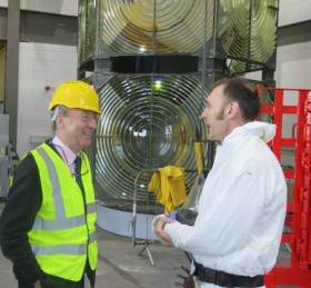
#MinisterVisit - Minister for Transport, Shane Ross paid a visit to the Commissioners of Irish Lights headquarters in Dun Laoghaire Harbour recently.
Irish Lights operate an essential safety navigation service around the island of Ireland aimed at protecting people, property and the environment at sea. Afloat adds this involves the use of an aids to navigation tender, ILV Granuaile, the workhorse of CIL's marine operations which is based in Dun Laoghaire Harbour. The facility there includes the main depot for buoy repair and maintenance.
Minister Ross heard about the range of new technologies that are enabling better navigation services for the mariner and the provision of new services such as environmental and ocean data for improved weather forecasting and planning of commercial activities at sea.
The service ensures that over 300 general aids to navigation (physical and electronic) operate reliably and to international standards around our coast 24/7 and 365 days of the year. Irish Lights also inspects and monitors over 4000 local aids around the coast.
Irish Lights also supports the Great Lighthouses of Ireland initiative which sees almost 200,000 tourists annually visiting working lighthouses. Accommodation is available in selected lighthouses on a year-round basis.
Read Today's Irish Sailing & Boating E–News from Afloat.ie
Read Afloat's e–news below with all the latest sailing and boating highlights featuring: Star(fish) attractions: Why village sea centre & All-Ireland trail are shining bright; Txt for Spinal Injuries’ RIB; & save date for Ilen baa-rty
Sign up for a daily digest of Irish sailing and boating news direct to your email on our home page (bottom right).
|


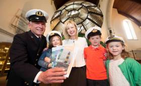
New Stamps Commemorate Irish Lights
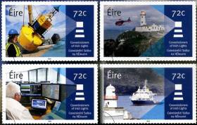
#IrishLights - An Post has today (Thursday 6 October) a set of stamps to commemorate the Commissioners of Irish Lights.
There are four stamps in the collection designed by Vermillion Design, featuring Irish Lights staff working on a buoy; a helicopter at work near Fanad lighthouse in Donegal; the technology Irish Lights offers to sea users; and the ILV Granuaile, the service’s multifunctional vessel.
Each highlights a different aspect of the agency’s navigation and maritime services which go beyond the many lighthouses in its coastal network, including some 4,000 local navigation aids such a buoys and marks on dangerous wrecks outside harbour areas.
The stamp set is available from post offices nationwide or online from the Irish Stamps website.
Exhibition: Safety at Sea through War and Upheaval: Irish Lights 1911-1923
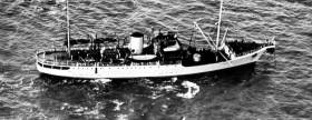
#Exhibition - The Commissioners of Irish Lights have joined the Royal Irish Academy to bring an exhibition that captures the history of Irish Lights, the history of the island of Ireland itself, its ever-changing coasts and shorelines, and the history of the people who lived along our island’s seaboard.
What emerges is a never-before told story of devotion to duty, scientific, engineering and physical endeavour, world war, revolution and change. It is also a deeply personal story of those who worked with and built up Irish Lights and who devoted their lives to protecting the coastline for the safety of all.
Through the nineteenth century the number of Ireland’s lighthouses increased from fourteen to seventy-four, with eleven lightships placed around the east and south coasts.
The exhibition explores how Irish Lights, with its origins in the late-eighteenth century, and coming of age in the certainties of the nineteenth, faced the challenges of global and national uncertainty in the early twentieth century. Precisely, the exhibition details Irish Lights’ history between 1911 and 1923.
This exhibition explores these years, and incredible events, such as; the Easter Rising of 1916, the Anglo-Irish War of 1919–1921, and the Anglo-Irish Treaty.
The exhibition will be showcasing in venues all along the Irish coastline in 2016.
Currently the exhibition is been held at Cobh Library on Casement Square until Saturday 15th October
Opening Times:Tuesday to Saturday - 9.30am - 5.30pm
Closed on Mondays and Saturdays
Travel Writer Impressed By Ireland's Tallest Lighthouse
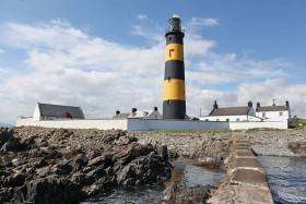
#Lighthouses - Guardian travel writer Yvonne Gordon was impressed by a recent visit to St John’s Point Lighthouse in Co Down, part of the Great Lighthouses of Ireland tourism initiative launched last year.
In operation since the Victorian era, the structure south of Killough is still a working lighthouse, but now visitors can stay in two of the former light keeper's cottages adjacent to the building.
The tallest lighthouse on Ireland's coastline at 40 metres, it also has a literary connection, as playwright and author Brendan Behan followed in his father's footsteps as a lighthouse painter when he helped slap a coat on the tower in 1950 – though not necessarily to the satisfaction of his employers.
The Guardian has more on the story HERE.
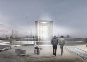
#MewIslandOptic - A rare lighthouse lens that helped guide ships into Belfast Lough for more than a century is to get a new home on the city's waterfront, as the Belfast Telegraph reports.
The optic from Mew Island Lighthouse, one of Ireland's tallest lights, will be housed in a much more accessible structure designed by architects Hall McKnight.
The firm fended off 11 other tenders to win the commission by the Titanic Foundation for the new monument to Northern Ireland's seafaring traditions, one that's intended to last for at least another 100 years.
With a design echoing a lighthouse lantern room, the structure will house what's believed by many to be the largest Fresnel lens, produced in Paris by master glassmakers in 1887.
The Belfast Telegraph has more on the story HERE.
Fastnet Lighthouse Part Of New Wave Action Study
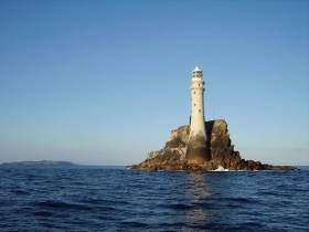
#Lighthouses - Fastnet Rock is part of a new €1.3 million, three-year project studying the effects of wave action on offshore lighthouses around the UK and Ireland.
As Phys.org reports, the STORMLAMP project – or STructural behaviour Of Rock Mounted Lighthouses At the Mercy of imPulsive waves – comprises marine science researchers from University College London and the Universities of Plymouth and Exeter, some of whom have already conducted a trail at Plymouth's Eddystone Lighthouse.
The team will use specialised equipment to measure the vibrations endured by lights found in some of the roughest seas around these islands.
The recorded data will then feed into sophisticated computer models that will predict the longevity of rock-based lighthouses in Cornwall, the Channel Islands and the west coast of Scotland, besides Fastnet off West Cork, and identify whether any remedial works would be required.
Phys.org has much more on the story HERE.
Visit Great Lighthouses of Ireland to Shine a Light on Summer!
#GreatLighthouses - This May Bank Holiday (30 April-2 May) kick start your summer and get out to visit the Great Lighthouses on this island for a weekend of fun, discovery, stories and thrills.
Walk through time, meet fifth-century monks, medieval Knights, discover all about the life of Lighthouse keepers at Hook Lighthouse on their new Ireland’s Ancient East tour experience, hear the tales of wrecks and lifesaving feats, as well as having ceol agus craic at Fanad - voted one of the most beautiful lighthouses in the world.
Take guided tours of Loop Head Lighthouse and its award winning peninsula and return for a feast of seafood and fun.
Tie nautical knots and welcome back the puffins as they clown around squawking and sea diving at Rathlin West Light Seabird Centre. Enjoy a traditional music session in the lighthouse keeper’s dwelling house and watch helicopter sea rescue manoeuvres at Valentia Island Lighthouse.
Hear the Singing Sistas at Clare Island Lighthouse and listen to the tales and stories of Lighthouse Keeping on Ballycotton Island. Get tips on being safe and enjoying our coast this summer, explore our towers, discover their hidden secrets and much more.
For hundreds of years lighthouses have helped seafarers find their way. Now they shine their light on truly unique experiences around our stunning coastline.
Great Lighthouses of Ireland (www.greatlighthouses.com) invites visitors and friends to a feast of storytelling, music, workshops and of course tower tours in seven of our amazing lighthouses along the Wild Atlantic Way, Ireland’s Ancient East and all the way to Rathlin Island. A fun-filled weekend is promised.
Coastal partners and organisations such as Royal National Lifeboat Institute (RNLI), Coastguard and others will be onsite for demonstrations and talks in many of the locations.
This will be a special opportunity to get behind the scenes with experts from Irish Lights and learn about technology and navigation today. Local historians and Storykeepers will provide tours that showcase the natural and cultural highlights.
Yvonne Shields, Chief Executive of Irish Lights said; “Our visitors tell us that getting to the top of a lighthouse tower is a unique and special experience. This weekend we are encouraging everyone to come and enjoy all that the Great Lighthouses of Ireland has to offer. Irish Lights is delighted to support our partners to showcase the best of these locations.
Lighthouse keeping was a way of life for keepers and their families for well over 100 years. However, advances in technology meant that lighthouses could be automated, and while all our lighthouses are still fully operational, there is no longer a need for permanent lighthouse keepers to be stationed on site. Great Lighthouses of Ireland is a wonderful way of keeping this rich maritime heritage, and the legacy of these Lighthouse Keepers, alive.”
Great Lighthouses of Ireland is a new and exciting collaboration between many private and public organisations in coastal communities. The experience has been developed to build on the momentum of the Wild Atlantic Way and Ireland’s Ancient East and this event is supported by Fáilte Ireland.
Speaking at the opening of Fanad Head Lighthouse on Friday 29th April, Shaun Quinn CEO of Fáilte Ireland welcomed the inaugural Shine a Light on Summer Festival.
“Whether it’s Hook in Wexford, Valentia Island in Kerry, Loop Head in Clare, Fanad Head in Donegal or the Island Lighthouse towers in Cork and Mayo, this is the weekend to discover that part of Irish life and culture where the land meets the sea. We in Failte Ireland are delighted to support this event as it encourages visitors to embrace an authentic piece of our Irish past and to meet with the people and communities who are passionate about these unique places”
As Gerald Butler, Former Lighthouse Keeper & Current Lighthouse Attendant at Galley Head Lighthouse says, “It wasn’t a job – it was a way of life”
For event details and information about and booking Great Lighthouses of Ireland visit:www.greatlighthouses.com
Launch of World’s Largest 3D Wind Map Technology in Dublin Bay
#3DwindMaps -The world’s largest trial of scanning Light Detection and Ranging (LiDAR) technology by Carbon Trust is taking place on Dublin Bay. This is the latest Offshore Wind Accelerator (OWA) project designed to help reduce the cost of energy from offshore wind.
Over the next three months the most comprehensive test of scanning LIDAR technology will take place, where four different scanning LiDAR systems will be put through their paces, alongside three vertical profiling LiDARs for validation purposes. The project is being supported by independent renewable energy company, RES and maritime safety organisation, Commissioners of Irish Lights.
Accurate wind resource measurements are critical to wind farm development because they are used to calculate the potential energy yield from a wind farm, which dictates the terms of the project financing. This can be a significant proportion of the overall project cost, accounting for around 45 percent for an average wind farm.
Scanning LiDAR is not a new technology. Conventionally, it is used by the defence and aerospace industries to monitor for oncoming weather fronts. But it does not have a proven track record in offshore wind.
Normally wind resource is measured using large steel towers called met masts, which require a large capital investment (£10-£12m) incurred at risk before a project gets the go ahead adding significant upfront costs, which could inhibit the exploration of new sites. The OWA project aims to test how accurately scanning LiDAR technology can measure wind resource for potential wind farm sites, which could deliver significant cost savings in the early stages of wind farm development.
The OWA has been working for the past few years to support more cost effective solutions, focusing on the development and commercialisation of a number of floating LiDAR systems, to significantly reduce upfront capital expenditure. Yet measurements taken by both masts and floating LiDAR are limited in that they only provide a measurement of the wind resource at a single point in space. For an offshore wind farm covering an area of up to 200 square kilometres, this can create uncertainty on the wind speed at locations far from the measurement point. This is known as spatial variation, where measurements may not representative of the entire site. This is translated into risk incurring additional financing costs to wind farm development.
Scanning LiDAR technology has the potential to reduce the risk associated with spatial variation. These systems are capable of scanning with a usable range of between 10 to 30 kilometres, to impressive levels of detail, taking over 100 measurements per minute. This allows developers to build a much more detailed picture of a site, not only significantly reducing uncertainty of spatial variation, but also allowing developers to better plan the layouts of the turbines to best exploit the individual wind conditions at the site. Increasing confidence on spatial variation could reduce risk to minimal levels, which can save millions of pounds on a project and reduce the cost of energy from offshore wind.
A difference of only 0.2 mph in wind speed can result in significant variation of yield calculations over the lifetime of a wind farm. It is therefore critical that the industry has confidence in scanning LiDAR devices being sensitive enough to detect such small variations. The OWA trial aims to test the sensitivity of the devices to picking up these variations in wind resource.
GLA's to Hold ‘Innovation in Maritime Navigation’ Event
#NavigationEvent - The General Lighthouse Authorities (GLAs) of the UK and Ireland will hold an event on 2 March to explore the mix of technologies for future maritime navigation in 2030 and beyond, and identify potential complements to GNSS.
• The event will present ways to maintain safety of navigation in increasingly confined and congested shipping areas, supporting economic growth and protection of the marine environment
• It will explore technologies that could complement Global Navigation Satellite Systems (GNSS) for robust cost-effective navigation of ships in the future
• The event is held jointly with the Knowledge Transfer Network and the Royal Institute of Navigation
Whilst GNSS is likely to remain the most accessible and accurate primary source of navigation data, it is not infallible, and can be prone to interference. Navigable sea space is set to shrink, with more traffic and growing obstacles like wind farms and marine conservation areas.
Combined with a rise in GNSS jamming incidents, it is clear that the need for complementary technologies to provide robust and reliable navigation data is higher than ever.
Taking place at Trinity House Headquarters at Tower Hill London, the ‘Innovation in Maritime Navigation’ event will consider the potential and practicality of candidate technologies to complement GNSS, and counter threats to maritime safety, including:
• Beacon R-Mode: incorporating a ranging capability on existing DGPS beacon (or AIS) transmissions
• Quantum navigation: using next-generation quantum sensors to drastically improve inertial navigation, when GNSS signals are unavailable
• Signals of opportunity: using existing signals such as mobile, Wi-Fi, TV, and radio signals, to work out the user’s location
• Integrated Navigation Systems supporting ECDIS: multi-system receivers and sensor integration, possibly with innovative water reference systems, to provide position
The event will look at how these technologies, and others, may contribute to a future ship/shore resilient Position, Navigation and Timing (PNT) solution. It will also cover the perspectives of user requirements, research, technology readiness level, commercial exploitation, ship equipage, shore based infrastructure, regulatory action; factors that are important in assessing the future direction of maritime solutions.
Presenters include mariners, ship operators, navigation specialists and technology providers and delegates will have the opportunity to network and participate in a Q&A and panel discussion chaired by RAdm Nick Lambert, former UK National Hydrographer.
The event is free to attend but delegates must register in advance.


 linking Spain.")


 Michael Murphy Schull Harbour Sailing Club (SHSC), Eric Coogan Heineken Ireland, Mark Murphy, Commodore SHSC, Jack Allen SHSC, Carmel O'Regan SHSC, Cornelious Ndlovu, Schull Harbour Hotel Operations Manager and Derval Murphy SHSC")


