Menu

Ireland's sailing, boating & maritime magazine

Displaying items by tag: normandy channel race

Irish waters are the centre of attention for French offshore sailing fans today as the 12th CIC Normandy Channel Race races around the Fastnet Rock.

The five leaders in the 12th CIC Normandy Channel Race rounded Fastnet at dawn this morning. It’s the Franco-Spanish pairing aboard Redman (161) who were the first to reach the legendary lighthouse off the south-west tip of Ireland at 03 hours and 37 minutes UTC and switch back onto a course bound for the Scilly Isles and then on to Guernsey. Skippers Antoine Carpentier and Pablo Santurde del Arco are still leading the way now, but there is everything to play for at the head of the fleet given the tight bunching of the front runners. Polled at the Fastnet course mark, there was just one hour separating boat number 161 and fourth placed Lamotte Module Création (153). And the tension is set to rise aboard the Class40s…

Purple arrows represent French Class40 yachts in Irish waters this morning. The boats are competing in the Normandy Channel RacePurple arrows represent French Class40 yachts in Irish waters this morning. The boats are competing in the Normandy Channel Race

As forecast, the competitors were racing all night long in a E/NE’ly wind fluctuating between 10-12 knots with gusts of 20 knots. It resulted in the Class40s having to zigzag their way downwind along the coast of southern Ireland in a gybing battle to find the best strategic position, alternately closing on and distancing themselves from the Emerald Isle in a bid to hunt down some breeze, whilst trying to avoid punching into the current and cover their rivals. It’s a scenario that didn’t leave a great deal of respite for the sailors and is ongoing for the second and third pelotons of the fleet who are on the chase between the two Irish lighthouses of Tuskar and Fastnet.

Over the course of the day, the heart of a stormy low-pressure system rolling in from the south will cross paths with the competitors as they make towards the Channel Islands. The upshot of this little encounter will likely be somewhat reminiscent of the doldrums with no wind other than that produced by the storm clouds. The leaders will be the first to negotiate this particular weather phenomenon. Another tricky tactical section ahead then for the crews in this 2021 edition of the CIC Normandy Channel Race. Something to reshuffle the cards once more perhaps…?

Published in Class40

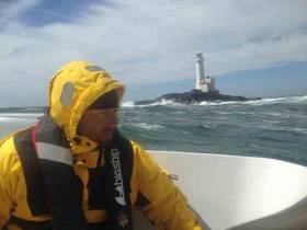
It’s been a studious, laborious night for the 20 competitors still out on the offshore race track in the Normandy Channel Race. The SW’ly wind is right on the nose as they continue to battle towards Fastnet Rock after rounding the Tuskar mark yesterday afternoon. Twice the distance, three times the effort it is often said. Indeed, the Class 40s are embroiled in a series of tedious tacks upwind in a bid to make even minimal headway, with a heavy price to pay in terms of physical effort and strategic cogitation, with every sail manœuvre requiring a serious amount of stacking, which consists of shifting any movable weight in the boat to the other tack, from heavy sail bags to personal belongings. However, a sailor has a sense of humour and also knows a thing or two about philosophising, as evidenced by this short message from Halvard Mabire (Campagne de France) last night: “The work on deck is quite a laugh, but the shifting of gear down below is no joke, especially whilst the floor is constantly jumping around and moving. It’s easy to keep hitting yourself against the walls and bulkheads and taking a bath is out of the question, otherwise you’re at risk of setting the tongues wagging on the dock (because it’s common knowledge that nobody believes you if you say you’ve walked into a door to explain a black eye...)”.

After a quick exit from the English Channel and an ultra fast climb up to Tuskar, the race pace has dropped off considerably and the ability to make headway has greatly reduced. A firm leader, Imerys (Phil Sharp - Pablo Santurde), which has consolidated its lead overnight, (over 13 miles) has only covered 89 miles in the space of 24 hours in reality, or an average speed of less than 4 knots. The British-Spanish pairing is just 20 miles or so from the famous rock this morning, which it is likely to round late morning, before linking onto a rapid negotiation of the Irish Sea, beam onto what is set to be a W’ly wind. As is often the case, beating tends to reshuffle the cards and behind Imerys the battle for the top spots is fierce. Gambling hard, V and B (Sorel-Carpentier) has sacrificed her second place to hunt down a little more pressure a long way South, and with it a decent wind angle that will enable her to drive straight down towards Fastnet and hopefully be in with a chance of getting the better of Serenis Consulting (Galfione- Troussel).

With the passage shortly after 02:00 GMT this morning of Team SPM (Bry-Day), all the protagonists have now rounded the Tuskar mark and are making for Fastnet.

Published in Offshore

#Offshore - A fleet of 20 French yachts racing to Ireland narrowly avoided sailing into serious trouble off the Dorset coast earlier this week.

As BBC News reports, UK coastguard authorities scrambled to warn the yachts via emergency broadcast that they were headed towards an exclusion zone set up for a live firing exercise at Lulworth Ranges.

"It looks like there was a slight error made by the French authorities," said a coastguard spokesperson, who confirmed that the yachts were diverted from their dangerous course after contacting the race director.

According to Practical Boat Owner, the yachts were competing in the Normandy Channel Race which began on Sunday 14 April and continues till this Friday evening.

The race route to and from Caen in northern France traverses a triangle across the Celtic Sea, past the most southwesterly tip of Cornwall, via Tuskar Rock and Fastnet Rock.

Published in Offshore

Having tacked down the southern seaboard of Ireland after rounding Tuskar Rock, all boats in the Normandy Channel Race have now rounded the Fastnet and are heading east on the homeward leg. The Normandy Channel Race is one of many that visit Irish waters without stopping, with the Mini Fastnet and others dipping into our territory to find a high-profile rock before fleeing again.

The 8 competitors  are making for the Scilly Isles, a string of rocks scattered about the South-West tip of England. To the great delight of these sailors, the fog, which has been tenaciously clinging onto them for the past three days, is gradually dissipating the further South the Class 40s sail. However, little else has changed and they’re still canted over against the wind as they make headway towards the English Channel and Normandy.

"Destination Dunkerque" skippered by Thomas Ruyant-Tanguy Leglatin is continuing what can only be described as a faultless race, admirably optimising their course. No pointless tacks for Tom and Tang then, who are just 300 miles from the finish this morning. Last night’s SE’ly breeze is likely to ease as day breaks and shift further round to the East. As such the ETAs don’t see the fleet crossing the line in Hermanville sur Mer before Sunday morning. In the wake of these solid leaders, the Dutch-Belgian duo Roelland Frannssens-Michel Kleinjans (Moonpalace) were still battling it out for second place with Halvard Mabire and Peter Harding yesterday. However, since then the two boats have split apart with a massive 20 mile lead going to “40 Degrees”. "Moonpalace” must now keep an eye on what’s going on around her and in particular the ‘miraculous’ performance by "Appart City" skippered by Yvon Noblet and David Taboré, which we can recall came close to dismasting two days ago and has since been sailing with a patched-up rig.
Night message from Halvard Mabire, co- skipper to Peter Harding in the Class 40 “40 Degrees”, currently second in the Normandy Channel Race:
"We can’t really say that we saw a lot of Ireland! The Fastnet? We barely saw the base of the rock when we went round it. We didn’t even see the base of the lighthouse. Nothing. You have to wonder a little about how, long ago, you could have managed to sail this course, almost constantly skimming past the rocks without ever seeing them. However the GPS doesn’t date back that long ago. It became fairly commonplace in the early nineties. In 91 we began to have them on the Figaro, which shook things up a bit. ‘Long ago’, which does seems a long time ago now (it has to be said that it was during the last century, in the period of black and white and silent films!), even before you knew where you were going, you already had to know where you were. Today we know perfectly well where we are, even if we can’t see a thing! When you think about it it’s funny to know exactly where you are on a map, or on a computer screen, whilst in fact you’re nowhere because you can’t see anything! Where does the reality end and the virtual begin? What’s staggering is the speed at which things become part of everyday life on a cultural level. Today nobody wonders about the very recent problems of positioning because we’re surrounded by GPS systems, which are constantly telling us not just where we are, but can also track anything or anyone. Anybody can position any object or any person on a map, without even knowing which way is North, or without having the slightest idea about basic orientation in relation to the sun. Once the great mystery of positioning is no longer there, it becomes more difficult to do something sensational. Everyone remembers Tabarly looming up out of the fog in Newport to take victory in the Transat in ‘76. Probably an element of the media success of this victory stemmed from the fact that it was unexpected and that it came out of the fog like a divine apparition.
Now you all know where we are and the ranking, which is constantly displayed, no longer allows you to fill pages with suppositions and forecasts. I’m under the impression that everyone wonders a bit about what they’re going to be able to talk about. That’s why they ask us if we have a ‘strategy’. At the risk of disappointing a lot of people, I can tell you that strategy, that’s to say deciding in advance what you’re going to do, is a load of hot air for boats like the Class40s. Solely the big multihulls vying for transoceanic records can really play with the weather, otherwise, as a general rule, it’s the weather that plays around with the boats. We find ourselves in a particular place at a particular time and there are not really any choices to be made. Or rather, if you can choose, it comes down to trying not to do something silly or avoiding doing something you mustn’t do on any account and that’s how you ‘give up’ up places to others. When you’re making virtually no headway at all, you can’t ‘traverse’ the race zone to hunt down a miracle. That’s why you notice that more and more the “fleet is right” (which is par for the course with the rising standards) and that ultimately the winner has rarely strayed far from the most direct course. The positioning of the race boats really comes down to a series of reactions in relation to an instantaneous situation, rather than a strategy decided in advance. All that to say, on 40 Degrees the strategy is not to have one and instead it’s all about adapting as best you can to the situations which present themselves."
Follow the race online with their tracker map.


Published in News Update

About Dublin Port 

Dublin Port is Ireland’s largest and busiest port with approximately 17,000 vessel movements per year. As well as being the country’s largest port, Dublin Port has the highest rate of growth and, in the seven years to 2019, total cargo volumes grew by 36.1%.

The vision of Dublin Port Company is to have the required capacity to service the needs of its customers and the wider economy safely, efficiently and sustainably. Dublin Port will integrate with the City by enhancing the natural and built environments. The Port is being developed in line with Masterplan 2040.

Dublin Port Company is currently investing about €277 million on its Alexandra Basin Redevelopment (ABR), which is due to be complete by 2021. The redevelopment will improve the port's capacity for large ships by deepening and lengthening 3km of its 7km of berths. The ABR is part of a €1bn capital programme up to 2028, which will also include initial work on the Dublin Port’s MP2 Project - a major capital development project proposal for works within the existing port lands in the northeastern part of the port.

Dublin Port has also recently secured planning approval for the development of the next phase of its inland port near Dublin Airport. The latest stage of the inland port will include a site with the capacity to store more than 2,000 shipping containers and infrastructures such as an ESB substation, an office building and gantry crane.

Dublin Port Company recently submitted a planning application for a €320 million project that aims to provide significant additional capacity at the facility within the port in order to cope with increases in trade up to 2040. The scheme will see a new roll-on/roll-off jetty built to handle ferries of up to 240 metres in length, as well as the redevelopment of an oil berth into a deep-water container berth.

Dublin Port FAQ

Dublin was little more than a monastic settlement until the Norse invasion in the 8th and 9th centuries when they selected the Liffey Estuary as their point of entry to the country as it provided relatively easy access to the central plains of Ireland. Trading with England and Europe followed which required port facilities, so the development of Dublin Port is inextricably linked to the development of Dublin City, so it is fair to say the origins of the Port go back over one thousand years. As a result, the modern organisation Dublin Port has a long and remarkable history, dating back over 300 years from 1707.

The original Port of Dublin was situated upriver, a few miles from its current location near the modern Civic Offices at Wood Quay and close to Christchurch Cathedral. The Port remained close to that area until the new Custom House opened in the 1790s. In medieval times Dublin shipped cattle hides to Britain and the continent, and the returning ships carried wine, pottery and other goods.

510 acres. The modern Dublin Port is located either side of the River Liffey, out to its mouth. On the north side of the river, the central part (205 hectares or 510 acres) of the Port lies at the end of East Wall and North Wall, from Alexandra Quay.

Dublin Port Company is a State-owned commercial company responsible for operating and developing Dublin Port.

Dublin Port Company is a self-financing, and profitable private limited company wholly-owned by the State, whose business is to manage Dublin Port, Ireland's premier Port. Established as a corporate entity in 1997, Dublin Port Company is responsible for the management, control, operation and development of the Port.

Captain William Bligh (of Mutiny of the Bounty fame) was a visitor to Dublin in 1800, and his visit to the capital had a lasting effect on the Port. Bligh's study of the currents in Dublin Bay provided the basis for the construction of the North Wall. This undertaking led to the growth of Bull Island to its present size.

Yes. Dublin Port is the largest freight and passenger port in Ireland. It handles almost 50% of all trade in the Republic of Ireland.

All cargo handling activities being carried out by private sector companies operating in intensely competitive markets within the Port. Dublin Port Company provides world-class facilities, services, accommodation and lands in the harbour for ships, goods and passengers.

Eamonn O'Reilly is the Dublin Port Chief Executive.

Capt. Michael McKenna is the Dublin Port Harbour Master

In 2019, 1,949,229 people came through the Port.

In 2019, there were 158 cruise liner visits.

In 2019, 9.4 million gross tonnes of exports were handled by Dublin Port.

In 2019, there were 7,898 ship arrivals.

In 2019, there was a gross tonnage of 38.1 million.

In 2019, there were 559,506 tourist vehicles.

There were 98,897 lorries in 2019

Boats can navigate the River Liffey into Dublin by using the navigational guidelines. Find the guidelines on this page here.

VHF channel 12. Commercial vessels using Dublin Port or Dun Laoghaire Port typically have a qualified pilot or certified master with proven local knowledge on board. They "listen out" on VHF channel 12 when in Dublin Port's jurisdiction.

A Dublin Bay webcam showing the south of the Bay at Dun Laoghaire and a distant view of Dublin Port Shipping is here
Dublin Port is creating a distributed museum on its lands in Dublin City.
 A Liffey Tolka Project cycle and pedestrian way is the key to link the elements of this distributed museum together.  The distributed museum starts at the Diving Bell and, over the course of 6.3km, will give Dubliners a real sense of the City, the Port and the Bay.  For visitors, it will be a unique eye-opening stroll and vista through and alongside one of Europe’s busiest ports:  Diving Bell along Sir John Rogerson’s Quay over the Samuel Beckett Bridge, past the Scherzer Bridge and down the North Wall Quay campshire to Berth 18 - 1.2 km.   Liffey Tolka Project - Tree-lined pedestrian and cycle route between the River Liffey and the Tolka Estuary - 1.4 km with a 300-metre spur along Alexandra Road to The Pumphouse (to be completed by Q1 2021) and another 200 metres to The Flour Mill.   Tolka Estuary Greenway - Construction of Phase 1 (1.9 km) starts in December 2020 and will be completed by Spring 2022.  Phase 2 (1.3 km) will be delivered within the following five years.  The Pumphouse is a heritage zone being created as part of the Alexandra Basin Redevelopment Project.  The first phase of 1.6 acres will be completed in early 2021 and will include historical port equipment and buildings and a large open space for exhibitions and performances.  It will be expanded in a subsequent phase to incorporate the Victorian Graving Dock No. 1 which will be excavated and revealed. 
 The largest component of the distributed museum will be The Flour Mill.  This involves the redevelopment of the former Odlums Flour Mill on Alexandra Road based on a masterplan completed by Grafton Architects to provide a mix of port operational uses, a National Maritime Archive, two 300 seat performance venues, working and studio spaces for artists and exhibition spaces.   The Flour Mill will be developed in stages over the remaining twenty years of Masterplan 2040 alongside major port infrastructure projects.

Source: Dublin Port Company ©Afloat 2020.