


Displaying items by tag: ocean acidification
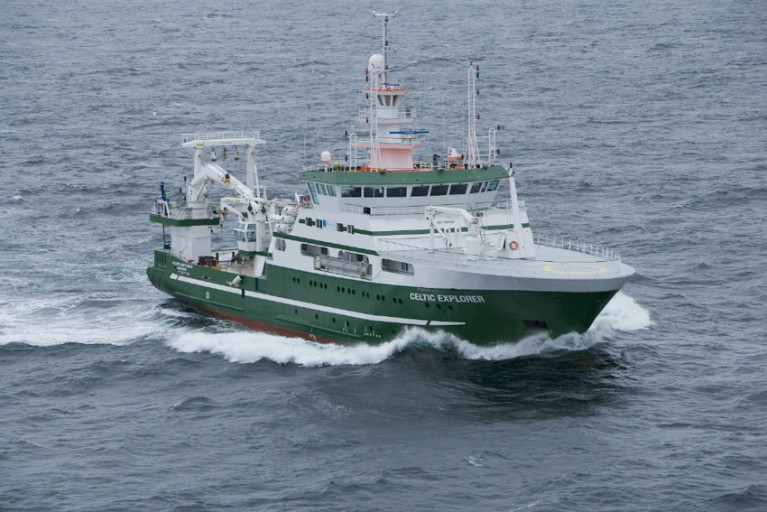
Surface ocean carbon dioxide observations collected by the Marine Institute’s RV Celtic Explorer have been published in the 2020 version of the Surface Ocean Carbon Atlas (SOCAT).
These data provide scientists, climate researchers and international policy makers with essential information on ocean carbon dioxide measurements.
About 36 billion tonnes of carbon dioxide are added to the atmosphere each year as a result of human activities. The ocean absorbs about one-quarter of these emissions, which helps to slow down climate change by removing CO2 from the atmosphere.
However, absorbing additional CO2 increases the acidity of seawater. This process is known as ocean acidification, and it could have dramatic consequences for marine life.
The impacts of ocean acidification would extend up the food chain, threatening food security for millions of people
If sea water is too acidic, it can make it difficult for marine organisms such as coral, oysters and mussels to form shells and skeletons.
Ocean acidification may impact some plankton species, which form the base of marine food webs and would impact larger animals like fish and whales.
The impacts of ocean acidification would extend up the food chain, affecting fisheries and aquaculture, threatening food security for millions of people, as well as the tourism industry.
Ocean acidification is a global problem. The European Union has committed to cut its greenhouse gas emissions by at least 40% below 1990 levels by 2030 and aims to be climate-neutral — an economy with net-zero greenhouse gas emissions — by 2050.
To understand the Earth’s changing climate, it is essential to collect high-quality data on surface ocean CO2 levels.
Since 2017, the Marine institute has been measuring dissolved carbon dioxide (pCO2) in Irish and Atlantic surface waters using a General Oceanics pCO2 system on board the RV Celtic Explorer. This system enables near-continuous and high-accuracy carbon dioxide measurements in surface water and the atmosphere when the vessel is at sea.
The close collaboration between the Marine Institute and P&O Maritime Services, with support from GEOMAR in Germany, has resulted in the successful collection of this data.
SOCAT has become a milestone in research co-ordination, data access, climate research and in informing policy
The high-quality measurements of CO2 collected by the Marine Institute are now included in the 2020 version of the Surface Ocean Carbon Atlas (SOCAT) and fill “a notable data gap”, according to the Irish State agency for marine research.
The Marine Institute submitted data from nine surveys in 2017 and a further 15 surveys in 2018 to SOCAT, whose data set os used globally by climate researchers and contribute to the work of the Intergovernmental Panel on Climate Change (IPCC).
SOCAT has become a milestone in research co-ordination, data access, climate research and in informing policy, the Marine Institute says.
And this work further contributes to collaborative research on ocean carbon and acidification undertaken over the last decade by the institute and NUI Galway.
Margot Cronin, chemist at the Marine Institute, said: “Measuring carbon dioxide in Irish and Atlantic waters provides essential data that increases the understanding of our oceans and climate.
“The Marine Institute is contributing to global science, providing advanced scientific knowledge which will help inform policy and our response to a changing ocean.”
As previously reported on Afloat.ie, the Marine Institute’s latest Oceans of Learning series focuses on our changing ocean climate with videos, interactive activities and downloadable resources.
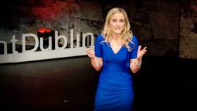
#MarineScience - A talk on how pollution is changing the chemistry of the seas around Ireland has been selected as a featured video by TED.com.
The talk by Irish marine scientist and Fulbright Scholar Dr Triona McGrath discusses the process of ocean acidification, caused by the absorption of carbon dioxide in the atmosphere into the world’s oceans.
A post-doctorate researcher at NUI Galway, Dr McGrath presented her talk on 6 February last year to a local audience at TEDxFulbrightDublin, organised by the Fulbright Commission in Ireland and Fulbright alumnus Dr Lorcan Walsh.
Dr McGrath’s team monitors levels of carbon dioxide in Irish marine waters to determine the level of carbon in the ocean and subsequent increase in ocean acidity.
Along with her colleagues, she published the first rates of ocean acidification for Irish offshore waters and the first baseline dataset of carbon parameters in Irish coastal waters.
This data is crucial for our understanding of the future health of our oceans, and can provide information to determine the impacts of ocean acidification on marine ecosystems.
In her talk, Dr McGrath states: “Ocean acidification is a global threat ... The rate of acidification is ten times faster than any acidification in our oceans for over 55 million years, our marine life has never experienced such a fast rate of change before ... There was a natural acidification event millions of years ago, it was much slower than what we're seeing today, this coincided with the mass extinction of many marine species.”
She also warns: “We will see acidification, we have already put too much carbon dioxide into the atmosphere ... but we can slow this down, we can prevent the worst case scenario. The only way of doing that is by reducing our carbon dioxide emissions.”
As a Fulbright Scholar, Dr McGrath visited the Scripps Institution of Oceanography in San Diego in 2013 to develop her analytical skills in ocean carbon chemistry.
A researcher in ocean climate change since 2008, her latest research project started in February 2017 and for the next four years she will work with colleagues to further develop ocean acidification research through the continuation of an ongoing time series in the Rockall Trough and the determination of seasonal and inter-annual variability of the carbon system in coastal waters.
Dr McGrath has a PhD in Chemical Oceanography and a BSc in Marine Science from NUI Galway.
Open Lecture On Ocean Acidification At NUI Galway
#MarineScience - NUI Galway will host a public seminar examining ocean acidification next Wednesday 16 September.
Ocean acidification arises as a result of the ongoing decrease in the pH of the Earth’s oceans, caused by the uptake of carbon dioxide from the atmosphere.
One of the world-leading authorities on ocean acidification, Dr Richard Feely of the National Oceanic and Atmospheric Administration (NOAA) Pacific Marine Environmental Laboratory in Seattle will discuss the present and future implications of increased carbon dioxide levels on the health of our ocean ecosystems and related ocean-based economies.
The lecture will take place at 7.30pm in the Aula Maxima at NUI Galway and is free to the public. Advance registration is advised as the number of places is limited. To register click HERE.
State Research Body Backs Call for Marine Protected Areas
Speaking from the launch of the report in Bergen, Norway, Minister of State with responsibility for Sustainable Transport, Horticulture, Planning and Heritage, Mr. Ciaran Cuffe T.D. said that Ireland welcomed this evidence-based assessment of the marine environment as a 'major milestone.'
"Such periodic holistic assessments are essential 'barometers' allowing policy makers to gauge overall progress towards sustainable management and identify those actions essential to deliver clean, diverse, healthy and productive seas around us," said Minister Cuffe. "Such actions are critical to maintaining our seas and oceans as a sustainable resource for this and future generations."
According to the Report, climate change and ocean acidification effects are now evident especially in the northern OSPAR areas. In addition, human uses of the marine environment, such as offshore renewable energy, offshore oil and gas production, mineral extraction and shipping, are increasing and must be managed in a coordinated way, backed up by research on impacts, if environmental damage is to be avoided.
Furthermore, the decline in biodiversity is far from being halted and actions, such as extending the network of offshore Marine Protected Areas (MPAs), are required to improve the protection of threatened and/or declining species and habitats. In December 2009 Ireland designated 19 MPAs including 4 offshore MPAs.
However, the Report states that there has been progress in reducing pollution from nutrients, certain hazardous substances and radioactive substances in our oceans and seas, although continued efforts are needed. In addition, there have been improvements in fisheries management, although fishing activities continue to have large impacts on marine ecosystems in the seas around Ireland.
"The Marine Institute is delighted to have participated closely in the development and production of this assessment by acting as the focal point for Irish involvement in the process and by providing data and scientific input," said Dr. Peter Heffernan, CEO of the Marine Institute. The QSR 2010 Report is a product of cooperation between many experts from 15 OSPAR countries. The Department of Environment, Health and Local Government act as Head of Delegation for Ireland to OSPAR.


. He learned his sailing in the Royal Cork at Crosshaven but left Ireland (as did many others) in 1985 and is now so into America’s West Coast sailing scene that he owns a classic Cal 40")


 Michael Murphy Schull Harbour Sailing Club (SHSC), Eric Coogan Heineken Ireland, Mark Murphy, Commodore SHSC, Jack Allen SHSC, Carmel O'Regan SHSC, Cornelious Ndlovu, Schull Harbour Hotel Operations Manager and Derval Murphy SHSC")

