


Displaying items by tag: pot fishing
The Department of Transport has issued an updated advisory for 2023 over the risk of vessels becoming entangled in ropes used in pot fishing.
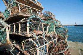
Marine Notice No 31 of 2023 supersedes No 43 of 2021 and reminds all vessel owners, agents, shipmasters, skippers, fishers, yachtsmen, seafarers and those engaged in pot fishing about the risks of vessels’ propellers becoming entangled in ropes of marker buoys used to indicate the position of pots used for fishing lobster, crab or other fish or shellfish.
This can occur because the length of rope used to fix marker buoys is too long, resulting in the line floating on or just below the surface.
The use of too long a line of rope can result in a situation where even vessels that have taken a wide berth around marker buoys could have their propellers fouled by the rope.
Specifically, the department reminds those engaged in pot fishing not to use unsuitable ‘floats’ (eg empty drink cans, plastic bottles, dark-coloured floats, etc) which offer poor visibility and/or could be mistaken for floating debris.
Fishers who carry out pot fishing (whether commercially or non-commercially) are reminded of their obligations to other users of the sea.
Furthermore, non-commercial pot fishers are reminded of the regulations made by the Department of Agriculture, Food and the Marine covering such activity (SI No 31 of 2016 - Non-Commercial Pot Fishing (Lobster and Crab) Regulations 2016) which, inter alia, limits the numbers of pots permitted per boat to a maximum of six, and such pot fishing to the months of May to September.
Any mariners who spot any marker buoys/ropes (or any other object) in the water, which they deem to represent a danger to navigation, should communicate information on same to other vessels in the area and to the Irish Coast Guard or to the local competent authority so that a hazard warning can be issued if appropriate, and any required follow-up action can be taken.
An updated guide on good practice for pots and marker buoys is included in Marine Notice No 31 of 2023 attached below.
Pot Fishers Reminded on Proper Use of Marker Buoys & Ropes
The Department of Transport has issued an updated advisory over the risk of vessels becoming entangled in ropes used in pot fishing.
Marine Notice No 43 of 2021 supersedes No 10 of 2019 and reminds all vessel owners, agents, shipmasters, skippers, fishers, yachtsmen, seafarers and those engaged in pot fishing about the risks of vessels’ propellers becoming entangled in ropes of marker buoys used to indicate the position of pots used for fishing lobster, crab or other fish or shellfish.
This can occur because the length of rope used to fix marker buoys is too long, resulting in the line floating on or just below the surface.
The use of too long a line of rope can result in a situation where even vessels that have taken a wide berth around marker buoys could have their propellers fouled by the rope.
Specifically, the department reminds those engaged in pot fishing not to use unsuitable ‘floats’ (eg empty drink cans, plastic bottles, dark-coloured floats, etc) which offer poor visibility and/or could be mistaken for floating debris.
Fishers who carry out pot fishing (whether commercially or non-commercially) are reminded of their obligations to other users of the sea.
Furthermore, non-commercial pot fishers are reminded of the regulations made by the Department of Agriculture, Food and the Marine covering such activity (SI No 31 of 2016 - Non-Commercial Pot Fishing (Lobster and Crab) Regulations 2016) which, inter alia, limits the numbers of pots permitted per boat to a maximum of six, and such pot fishing to the months of May to September.
Any mariners who spot any marker buoys/ropes (or any other object) in the water, which they deem to represent a danger to navigation, should communicate information on same to other vessels in the area and to the Irish Coast Guard or to the local competent authority so that a hazard warning can be issued if appropriate, and any required follow-up action can be taken.
A guide on good practice for pots and marker buoys is included in Marine Notice No 43 of 2021, which can be downloaded below.
In response to the recent MCIB report on a fatal incident involving a fishing vessel in Galway Bay in November 2017, the latest Marine Notice from the Department of Transport, Tourism and Sport (DTTAS) related to the safety of small vessels engaged in pot fishing.
The notice is directed at users of vessels less than 15m in length:
- Those engaged in non-commercial potting are encouraged to familiarise themselves with the Code of Practice for the Safe Operation of Recreational Craft and to comply with the statutory requirements highlighted by the Code, and heed the safety advice and recommendations of the Code.
- Those engaged in commercial potting should comply with the Code of Practice for the Design, Construction, Equipment and Operation of Small Fishing Vessels of less than 15m length overall. The Code sets out requirements and recommendations relating to safety on board small fishing vessels.
In addition, the DTTAS reminds users of small vessels that:
- Suitable personal flotation devices (PFDs) and personal locator beacons (PLBs) should always be worn.
- Somebody ashore should be aware of where the boat is intending to operate and when it is expected to return.
- Vessels should have a suitable means of re-boarding in the event of a crew member falling overboard.
The DTTAS said it wishes to highlight the increased risks involved with single-person operation of such vessels.
Owners/skippers should carry out a risk assessment of the intended operations and take appropriate actions to reduce and/or mitigate the inherent risks that arise when nobody else is on board to render assistance or to raise the alarm.
The Department of Transport, Tourism and Sport (DTTAS) has issued a new advisory over the risk of vessels becoming entangled in ropes used in pot fishing.
Marine Notice No 10 of 2019 supersedes No 26 of 2016 and reminds all vessel owners, agents, shipmasters, skippers, fishers, yachtsmen, seafarers and those engaged in pot fishing about the risks of vessels’ propellers becoming entangled in ropes of marker buoys used to indicate the position of pots used for fishing lobster, crab, or other fish or shellfish.
This can occur because the length of rope used to fix marker buoys is too long, resulting in the line floating on or just below the surface.
The use of too long a line of rope can result in a situation where even vessels that have taken a wide berth around marker buoys could have their propellers fouled by the rope.
In addition, the DTTAS reminds those engaged in pot fishing not to use unsuitable ‘floats’ (eg empty drink cans, plastic bottles, dark-coloured floats, etc) which offer poor visibility and/or could be mistaken for floating debris.
Fishers who carry out pot fishing (whether commercially or non-commercially) are reminded of their obligation to other users of the sea.
Furthermore, non-commercial pot fishers are reminded of the regulations made by the Department of Agriculture, Food and the Marine covering such activity (SI No 31 of 2016 Non-Commercial Pot Fishing (Lobster and Crab) Regulations 2016), which inter alia limits the numbers of pots permitted per boat to a maximum of six, and such pot fishing to the months of May to September.
Any mariners who spot any marker buoys/ropes (or any other object) in the water, which is deemed to represent a danger to navigation, should communicate information on same to other vessels in the area and to the Irish Coast Guard or to the local competent authority so that a hazard warning can be issued if appropriate, and any required follow-up action can be taken.
A guide for fishers and other users entitled ‘Good Practice Guide to Pots and Marker Buoys’ is included in the annex of Marine Notice No 10 of 2019, a PDF of which is available to read or download HERE.
Protection Needed for Horse Mussels in Strangford Lough
A new study from Queen's University Belfast has revealed the extent of damage to horse mussel reefs in Strangford Lough, the Bray People reports.
The report highlighted a lack of action on the part of the NI government departments responsible for the lough, which is designated as a Special Conservation Area and a Marine Nature Reserve.
According to BBC News, previous studies in the late 1990s showed that many of the mussels were dead, and urged regulatory action to protect the remainer that did not come to pass until earlier this year, when two non-disturbance zones were declared to reduce pot fishing in the reef areas.
On top of the continued ban on mobile fishing gear, the new study recommends "total protection" in areas of the lough where fishing activity is affecting the recovery of horse mussel reefs, and notes that "signs of natural recovery might be expected within 20 years... provided there is no further disturbance".


 linking Spain.")


 Michael Murphy Schull Harbour Sailing Club (SHSC), Eric Coogan Heineken Ireland, Mark Murphy, Commodore SHSC, Jack Allen SHSC, Carmel O'Regan SHSC, Cornelious Ndlovu, Schull Harbour Hotel Operations Manager and Derval Murphy SHSC")


