


Displaying items by tag: reef
Artificial Reef, Tidal Pool and Canoe Trail Plans Among Outdoor Projects To Secure Government Funding
Scoping the creation of Ireland’s first underwater artificial reef in Mayo’s Killala Bay has received a grant of 50,000 euro as one of a number of outdoor projects approved for funding by Minister for Rural and Community Development Heather Humphreys.
Design of a recreational trail linking Cong to Lisloughrey pier has also secured 50,000 euro, while a sum of 35,847 euro has been approved for a feasibility study into a tidal pool on the Aran islands, Co Galway.
A total sum of 2.3 million euro has been approved under the Outdoor Recreation Infrastructure Scheme (ORIS) on improving or developing outdoor amenities such as walkways, cycleways, rivers, lakes and beaches.
 Minister for Rural and Community Development Heather Humphreys
This funding will be invested in 50 outdoor recreation projects that are currently at the early stage of development, according to Ms Humphreys, with sums of up to 50,000 euros to bring them to a “shovel-ready stage”.
They will then be in a position to secure further funding through the other measures of the Outdoor Recreation Infrastructure Scheme, she has said.
Other marine and freshwater projects approved include 47,579 euro for planning and design for water sports opportunities in New Ross and the tidal section of the River Barrow.
A study to identify the potential of the development of Cavan’s Swellan lough as a recreational amenity has been approved for 49,500 euro, while Leitrim and Cavan county councils secured 22,693.50 euro for a feasibility study on a canoe trail on Lough MacNean.
Oyster Reefs a Natural Solution to Storm Surges and Coastal Protection - NUI Galway study
There are many reasons to love oysters, and now an NUI Galway scientist has suggested another one.
Apart from its nutritional benefits, the shellfish also provides a cost-effective solution to the impacts of climate change.
Natural reefs built from oysters are preferential to seawalls constructed as a flood and coastal erosion defence, according to research led by NUI Galway (NUIG) economist Prof Stephen Hynes.
Such natural reefs are not only cheaper to construct, but they have the added benefit of creating new habitats for marine life, Prof Hynes, who is director of the NUIG Socio-Economic Marine Research Unit, says.
 Author Prof Stephen Hynes
“Nature-based solutions” to climate change are central to the European Green Deal, his research paper published in the science journal Ecological Economics notes.
Galway has long celebrated the oyster, and a coastal walk in Galway Bay was selected as a template for the study.
The coastal trail to Rinville point is three kilometres from Oranmore village in south Galway. As it lies at sea level, it is exposed to coastal flooding.
The research examined its recreational value and analysed two options for protecting it – the “hard engineering” rock armour solution versus constructing a natural reef from oysters cultivated locally.
Rinville bay was once nucleus for abundance of native oyster, dating from prehistoric times, but productive reefs have been overharvested to the extent that remaining stock is “close to functional extinction”.
However, community-based organisation, Cuan Beo, has been working with the Marine Institute on restoring the native oyster and the first effort to rebuild several oyster reefs began in late 2020.
Cuan Beo used 200 tonnes of empty Pacific oyster shells covering a 50-metre radius and one metre in height from the seabed, which was then seeded with native oyster stock.
Although these structures are not close enough to the point to protect the walk, a similar natural protective reef could be created if given legislative approval, Cuan Beo spokesman Diarmuid Kelly confirmed.
 Natural oysters
The oyster “bar” would be covered by sea most of the time, except at low tide, and would involve sowing seed oysters on top of empty oyster shell substrate
Prof Hynes’s study found that both protection options resulted in a positive net benefit over a 20-year time horizon.
However, the study found the nature-based solution had a benefit-cost ratio multiple times larger than the “grey infrastructure” seawall alternative.
Artificial oyster reefs have been piloted along the US Gulf Coast to protect and restore shoreline habitat and create living oyster beds, Prof Hynes notes.
The results of the research “suggest a compelling case for embedding nature-based solutions in climate adaption and flood management planning for low lying coastal areas where recreational resources are under threat”, his paper says.
“The fact that oyster reefs can also adapt to sea-level rise with vertical growth rates that are faster than the expected rate of sea-level rise also makes them a good nature-based solution,” he adds.
The full paper is here
Health of Caribbean Coral Reefs Threatened by "Aggressive Alga"
Coral reefs are under pressure from hurricanes, pollution, bleaching and global warming, and scientists have now confirmed the extent of the threat from an aggressive alga.
The algae, known as peyssonnelid algal crusts (PAC), are colonising reefs in the Caribbean at such an aggressive rate that they are interfering with the reef’s natural ecosystem, according to new research.
Marine biologists from the University of Oxford, California State University Northridge and the Carnegie Institution for Science who have been studying the issue for four years describe the extent of the threat in the Scientific Reports.
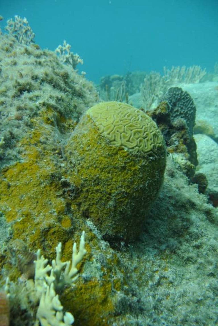
The golden-brown, crust-like alga is rapidly overgrowing shallow reefs, and has been described as an “ecological winner” by Dr Bryan Wilson of the University of Oxford’s department of zoology.
“It aggressively occupies any vacant space on the reefs, rapidly overgrows and kills live corals, prevents free-swimming coral larvae from settling on the benthos and becoming adult colonies, and is unaffected by the regular destructive hurricanes that sweep through the area,”he says.
‘It is also seemingly resistant to grazing by fish, and as far as we know, is only fed upon by a single creature, the black spiny urchin (Diadema antillarum),”he said.
The spiny urchin was once abundant in the Caribbean, but was effectively wiped out in the 1980s by a mysterious disease, he says.
“Our research has initially looked into the microbiology of PAC and compared it with that of close relatives (the crustose coralline algae, or CCA) which are known to stimulate the recruitment of coral larvae to reefs,”Dr Wilson says.
A key finding was that the PAC alga manages to inhibit the growth of beneficial marine bacteria which otherwise produce chemical compounds that attract coral larvae to the seafloor.
This means that reefs colonised by the alga are unlikely to host corals again.
The alga is described as having a “dark brown and dirty orange veneer” which stands out among the white sands and light greens, pinks, yellows and other colours that make up the reef.
The scientists say it is unclear if PAC is made up of one algal species or several, and they don’t know what is causing its rapid spread – but describe it as an “alarming trend”
They say that the next stage of their research will be to unravel the alga's “complex physiological mechanisms for this ecological success”, through studying its genome. Ultimately, they say they “hope to find ways to mitigate against this new threat”.
Cork Surfers Brave More Than The Cold!

There'a always a sliver lining around our coast. Whats a problem for some can be turned to advantage for others. A reef that sailors avoid during racing on coastal courses from Royal Cork presented the perfect setting for some Cork Harbour surfers at the weekend writes Brian Carlin.
A local hazard, the reef is situated approximately a mile west of the entrance to Cork Harbour, dangerous at high tide as most of the reef is immersed. SCROLL DOWN FOR IMAGES.
Surfers took advantage of the direct southerly swell, the surfers, Mark Barry, John Powell and Brian Hartnett, explained only in these conditions is the reef surfable. The trio enjoyed the best of the January sunshine and gave the shoreline spectators a show worth watching. Photos by Brian Carlin.
Giant Prowler Wave Location Remains Secret

According to a Press Association report one of the six-man team, Briton Andrew Cotton, first spotted it several years ago while on board an Irish Coast Guard helicopter after being rescued from a surf accident off Mullaghmore, Co Sligo.
Last night some west coast surfers told Afloat.ie the location is most likely off the Sligo coast, up to two kilometres offshore and close to an underwater reef.
The terrifying-looking wave, dubbed 'Prowlers', was reportedly up to 50ft high on Tuesday when the Irish, British, Australian and South African surfers ventured out. Photos of it appeared on the front page of the Irish Times yesterday.
The surf team included Bundoran's Richie Fitzgerald who says he had waited for five years for the type of conditions required to surf it and on Monday the waves were in the 40-50ft range. Conditions were perfect due to the massive swell generated by Hurricane Tomas.
Hurricane Produces West Coast 'Prowler'


, which is undergoing an upgrade in Turkey. Works include improvements to the survey support ship")


