


Displaying items by tag: rockfall
Dalkey Island Ferry Not Operating Due to Collapse at Cliff-Face Within South Dublin Bay Harbour
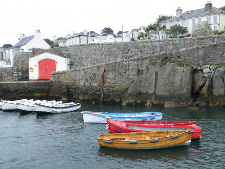
The popular Dalkey Island seasonal ferryboat has stopped service due to a partial collapse of a cliff-face underneath a footpath leading to the pier at Coliemore Harbour, Co. Dublin, writes Jehan Ashmore.
The ferry operator, Ken Cunningham said "unfortunately due to an incident in the harbour I cannot operate the ferry this weekend, its under investigation right now with DLRCoCo because part of the wall fell out where the walkway is and it is unsafe for anyone too walk down"
He added "I'm sorry for any inconvenience caused to anyone who was planning a trip over to the island this weekend. Hopefully, I won't be out of action for too long".
Directly below the footpath wall that provides access from Coliemore Road, is where the jagged chunk of cliff-face sheared off below into the harbour which during medieval times acted as the Port of Dublin. The only commercial operation using the beautiful stone-cut harbour now is the 'Ken The Ferryman' service until this week's rock-fall incident (see: facebook's close up photo).
 A close up of the affected cliff-face at Coliemore Harbour
The stretch of water across Dalkey Sound is a mere 300m between the mainland harbour and the landing slipway on the island which together in 2014 were upgraded by Dun Laoghaire-Rathdown County Council (DLRCoCo). For more details of these works (see p.23) of 'Maritime' Dalkey coverage in the Dalkey Community Council newsletters, also features the resumption of the ferry service after three years absence.
Due to Covid-19 restrictions the service was delayed from beginning earlier this season using instead of the Lilly Rose a new larger replacement passenger boat, Gemma but now currently off-service due to cliff rock-fall.
The ferryboat service at Coliemore Harbour is located less than a mile from Dalkey which is a designated 'Heritage Town' with its scenic coastline along the Dublin Riviera.
It is also along the harbour's footpath wall where local youths have been gathering and jumping off directly into the water below, however the fallen rock is now in this same area posing a danger to such activity. In addition the rock is a danger to nearby timber and fibreglass built moored boats.
DLRCoCo has blocked of Coliemore Harbour's walkway leading to the ferry pier with signs stating no unauthorised access and danger warnings of 'falling rocks' and 'closed due to repair works needed'. Access remains open but only to the slip and adjoining second pier with anglers given the mackeral season is underway.
The stretch of water between Coliemore and the island is named Dalkey Sound which is a mere 300m wide and is linked by the traditional ferryboat service.
In addition the affected walkway has also led to no access to Dalkey Rowing Club's premises and so coastal rowing of 'skiff' boats have been cancelled.
Ken the Ferryman is the sole operator providing exclusively the Department of Marine inspected and licensed passenger-boat service off the south Dublin suburb which has become more famous as it is host to the annual Dalkey Book Festival. This year's 10th festival, however was postponed due to Covid-19 public health restrictions.
Skellig Michael Opening In Doubt Over Unstable Rocks
#SkelligMichael - Skellig Michael’s opening for summer visitors on 14 May has been cast into doubt by concerns over of a number of unstable large rocks following a rockfall discovered earlier this month.
Safety contractors and OPW staff are currently assessing the situation at the Unesco World Heritage site, a major location in the upcoming blockbuster movie Star Wars: The Last Jedi.
But according to The Irish Times, the filming activity and increased visitor numbers are not to blame for the damage on what’s been dubbed ‘Star Wars Island’ — more likely caused by heavy winter storms and burrowing by the island’s rabbits.
As previously reported on Afloat.ie, evidence of a “deeply worrying” rockfall was found during pre-season checks by OPW staff on Friday 7 April.
Concern Over Skellig Michael Rockfall
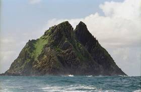
#IslandNews - A serious rockfall on Skellig Michael has been described as “deeply worrying” by a senior conservationist.
RTÉ News reports that the rockfall was discovered during pre-season checks by OPW staff last Friday (7 April), close to accommodation huts on the Co Kerry island’s Lighthouse Road.
The Unesco World Heritage site is due to open for visitors next month, with big numbers expected in the wake of its featuring in the new Star Wars movies.
OPW senior conservation architect Grellan Rourke said that if some of the “very large” rocks had come down on top of the huts “there would have been a significant threat to anyone inside”.
Experts will examine the rock slopes in question, with no confirmation of whether this would affect Skellig Michael’s opening date for visitors.
RTÉ News has more on the story HERE.
Rockfalls on Sceilig Mhichíl Cause Breach to Lighthouse Road
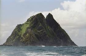
Rockfalls on Sceilig Mhichíl, (also known as Skellig Michael or Great Skellig Island), Co. Kerry have caused a breach to the Lighthouse Road wall, which forms the sole access to the monastic site from the island’s landing. The damage is reported as being significant and extensive, and the steep ground above the roadway may be subject to further rock falls following the heavy rains that have occurred over the winter months. This must be examined and repaired as required before public access is permitted.
The news was issued by The Department of Transport, Tourism and Sport to all Masters, Skippers, Seafarers, Fishers, Passenger Boat Operators and Owners and Users of Recreational Craft in Marine Notice this afternoon.
The OPW has advised that the island remains in a highly unstable and extremely dangerous condition and should, under no circumstances, be accessed by anyone other than the OPW project team and their contractors involved with the assessment of the damage and repairs. Any unauthorised persons landing on the island before the necessary repairs have been carried out would be exposed to considerable risk.
The Department of Transport, Tourism and Sport wishes to advise that, until further notice, persons should not be landed on the island from any vessel without the express consent of the OPW.
This Marine Notice will be cancelled at such time that the OPW advise that the repairs have been completed and the island has been re-opened to the public.


. He learned his sailing in the Royal Cork at Crosshaven but left Ireland (as did many others) in 1985 and is now so into America’s West Coast sailing scene that he owns a classic Cal 40")


 Michael Murphy Schull Harbour Sailing Club (SHSC), Eric Coogan Heineken Ireland, Mark Murphy, Commodore SHSC, Jack Allen SHSC, Carmel O'Regan SHSC, Cornelious Ndlovu, Schull Harbour Hotel Operations Manager and Derval Murphy SHSC")

