Menu

Ireland's sailing, boating & maritime magazine

Displaying items by tag: Admiralty

High Resolution images of a merchant ship which was sunk ninety-four years ago today (October 12th) off the coast of Dublin have been revealed by the INFOMAR (Integrated Mapping For the Sustainable Development of Ireland's Marine Resource) Programme during a mission on the national research vessel the RV Celtic Voyager earlier this year which surveyed the wreck of the first Guinness merchant vessel, the W.M. Barkley.

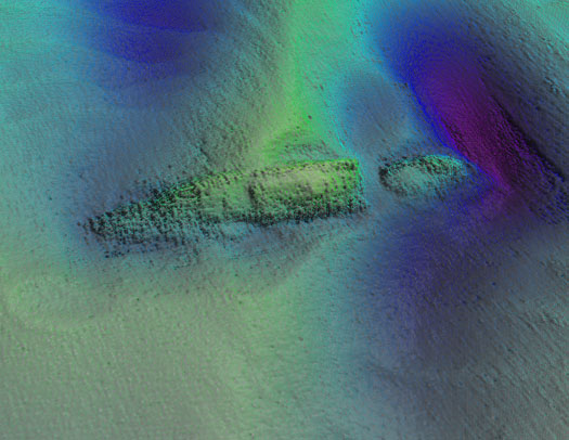
The detailed seabed images, which include deck features and complex sand wave structures, were recorded by towed sidescan sonar provided by the Moore Marine Group, and give a visual insight into the defensively armed ship that was sunk by a German torpedo in 1917, seven miles east of the Kish Bank off Dublin.

Photo_1_INFOMAR_image_of_W_M_Barkley_from_port_aft

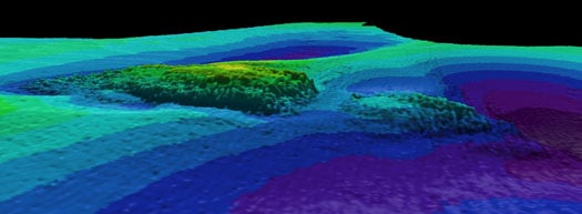
Photos above and below show topographic seafloor images in 3D, showing the partially buried wreck of the W M Barkley lying at a water depth of 56 metres; with deeper scouring around it down to 72 metres (darker colours indicate greater depths). The images were created from sonar data acquired onboard the Marine Institute's research vessel RV Celtic Voyager, during INFOMAR Programme mapping in 2010 and 2011 with data processed by INFOMAR's Fabio Sacchetti (University of Ulster) and Charise McKeon (Geological Survey of Ireland).

W_M_Barkley

In May 2010, during a large scale mapping survey in the Irish Sea by INFOMAR, a national marine study run by the Marine Institute and the Geological Survey of Ireland, identified a seabed feature which, to the trained eye, was discernable as a potential shipwreck lying in the same position recorded on the Admiralty Chart, the EU wreck site and UK Hydrographic Office wreck site directories, as well as a survey conducted in the 1980s as the last known position of the W.M.Barkley.

Viewing the spectacular imagery of the shipwreck Minister for Communications, Energy & Natural Resources, Pat Rabbitte, said "I am delighted to note the continued excellence of the valuable work being carried out under the INFOMAR project. These images from the deep reveal a unique view of part of Ireland's marine heritage and I am delighted to announce details of INFOMAR''s annual seminar to be held in Galway on November 16 and 17th."

Photo_3_Guinness_Archivist_Eibhlin_Roche_with_model_of_WM_Barkley

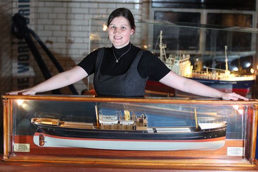
Eibhlin Roche - Guinness Archivist, Guinness Storehouse with the model of the W.M. Barkley. Photo: Jason Clarke Photography

Ninety four years ago on the dark night of October 12th 1917 the W.M.Barkley was torpedoed without warning by the German submarine UC-75. Within minutes the ship, which was owned and operated by the Guinness Company of Dublin, broke in two and sank, taking with her to the bottom four men including her Captain and leaving the rest of her crew to face the sea in an open lifeboat. Now, the darkness where the ship has lain in pieces has been disturbed, probed by fingers of sound that are mapping the seabed in incredible details and bringing to light the position of this famous Irish shipwreck.

"As the first Guinness owned ship, the W.M. Barkley played an important role in the story of the transportation of GUINNESS beer overseas," said Eibhlin Roche, Guinness Archivist. The events of the night of 12th October 1917 are very much part of the history of Guinness that is recorded in the Guinness Archive. It is exciting to finally know the exact resting place of the W.M. Barkley."

A scale model of the W.M. Barkley is on display in the Transport Gallery of Guinness Storehouse remembering the lives of the Guinness men who both perished and survived the events of 12th October 1917. These are stories of tragedy and bravery portraying Irish traditional values, and how they were brought to light with the application of cutting-edge technology.

Koen_Verbruggen_Minister_Rabbitte_Dr_Peter_Heffernan_Eibhlin_Roche_and_David_Smith

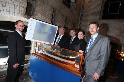
Koen Verbruggen (GSI), Minister Pat Rabbitte, Dr. Peter Heffernan (CEO, Marine Institute), Eibhlin Roche (Guinness Archivist, Guinness Storehouse) and David Smith (Country Director, Diageo Ireland) Photo: Jason Clarke Photography


Published in Marine Science

Dun Laoghaire Harbour Information

Dun Laoghaire Harbour is the second port for Dublin and is located on the south shore of Dublin Bay. Marine uses for this 200-year-old man-made harbour have changed over its lifetime. Originally built as a port of refuge for sailing ships entering the narrow channel at Dublin Port, the harbour has had a continuous ferry link with Wales, and this was the principal activity of the harbour until the service stopped in 2015. In all this time, however, one thing has remained constant, and that is the popularity of sailing and boating from the port, making it Ireland's marine leisure capital with a harbour fleet of between 1,200 -1,600 pleasure craft based at the country's largest marina (800 berths) and its four waterfront yacht clubs.

Dun Laoghaire Harbour Bye-Laws

Download the bye-laws on this link here

FAQs

A live stream Dublin Bay webcam showing Dun Laoghaire Harbour entrance and East Pier is here

Dun Laoghaire is a Dublin suburb situated on the south side of Dublin Bay, approximately, 15km from Dublin city centre.

The east and west piers of the harbour are each of 1 kilometre (0.62 miles) long.

The harbour entrance is 232 metres (761 ft) across from East to West Pier.

  • Public Boatyard
  • Public slipway
  • Public Marina

23 clubs, 14 activity providers and eight state-related organisations operate from Dun Laoghaire Harbour that facilitates a full range of sports - Sailing, Rowing, Diving, Windsurfing, Angling, Canoeing, Swimming, Triathlon, Powerboating, Kayaking and Paddleboarding. Participants include members of the public, club members, tourists, disabled, disadvantaged, event competitors, schools, youth groups and college students.

  • Commissioners of Irish Lights
  • Dun Laoghaire Marina
  • MGM Boats & Boatyard
  • Coastguard
  • Naval Service Reserve
  • Royal National Lifeboat Institution
  • Marine Activity Centre
  • Rowing clubs
  • Yachting and Sailing Clubs
  • Sailing Schools
  • Irish Olympic Sailing Team
  • Chandlery & Boat Supply Stores

The east and west granite-built piers of Dun Laoghaire harbour are each of one kilometre (0.62 mi) long and enclose an area of 250 acres (1.0 km2) with the harbour entrance being 232 metres (761 ft) in width.

In 2018, the ownership of the great granite was transferred in its entirety to Dun Laoghaire Rathdown County Council who now operate and manage the harbour. Prior to that, the harbour was operated by The Dun Laoghaire Harbour Company, a state company, dissolved in 2018 under the Ports Act.

  • 1817 - Construction of the East Pier to a design by John Rennie began in 1817 with Earl Whitworth Lord Lieutenant of Ireland laying the first stone.
  • 1820 - Rennie had concerns a single pier would be subject to silting, and by 1820 gained support for the construction of the West pier to begin shortly afterwards. When King George IV left Ireland from the harbour in 1820, Dunleary was renamed Kingstown, a name that was to remain in use for nearly 100 years. The harbour was named the Royal Harbour of George the Fourth which seems not to have remained for so long.
  • 1824 - saw over 3,000 boats shelter in the partially completed harbour, but it also saw the beginning of operations off the North Wall which alleviated many of the issues ships were having accessing Dublin Port.
  • 1826 - Kingstown harbour gained the important mail packet service which at the time was under the stewardship of the Admiralty with a wharf completed on the East Pier in the following year. The service was transferred from Howth whose harbour had suffered from silting and the need for frequent dredging.
  • 1831 - Royal Irish Yacht Club founded
  • 1837 - saw the creation of Victoria Wharf, since renamed St. Michael's Wharf with the D&KR extended and a new terminus created convenient to the wharf.[8] The extended line had cut a chord across the old harbour with the landward pool so created later filled in.
  • 1838 - Royal St George Yacht Club founded
  • 1842 - By this time the largest man-made harbour in Western Europe had been completed with the construction of the East Pier lighthouse.
  • 1855 - The harbour was further enhanced by the completion of Traders Wharf in 1855 and Carlisle Pier in 1856. The mid-1850s also saw the completion of the West Pier lighthouse. The railway was connected to Bray in 1856
  • 1871 - National Yacht Club founded
  • 1884 - Dublin Bay Sailing Club founded
  • 1918 - The Mailboat, “The RMS Leinster” sailed out of Dún Laoghaire with 685 people on board. 22 were post office workers sorting the mail; 70 were crew and the vast majority of the passengers were soldiers returning to the battlefields of World War I. The ship was torpedoed by a German U-boat near the Kish lighthouse killing many of those onboard.
  • 1920 - Kingstown reverted to the name Dún Laoghaire in 1920 and in 1924 the harbour was officially renamed "Dun Laoghaire Harbour"
  • 1944 - a diaphone fog signal was installed at the East Pier
  • 1965 - Dun Laoghaire Motor Yacht Club founded
  • 1968 - The East Pier lighthouse station switched from vapourised paraffin to electricity, and became unmanned. The new candle-power was 226,000
  • 1977- A flying boat landed in Dun Laoghaire Harbour, one of the most unusual visitors
  • 1978 - Irish National Sailing School founded
  • 1934 - saw the Dublin and Kingstown Railway begin operations from their terminus at Westland Row to a terminus at the West Pier which began at the old harbour
  • 2001 - Dun Laoghaire Marina opens with 500 berths
  • 2015 - Ferry services cease bringing to an end a 200-year continuous link with Wales.
  • 2017- Bicentenary celebrations and time capsule laid.
  • 2018 - Dun Laoghaire Harbour Company dissolved, the harbour is transferred into the hands of Dun Laoghaire Rathdown County Council

From East pier to West Pier the waterfront clubs are:

  • National Yacht Club. Read latest NYC news here
  • Royal St. George Yacht Club. Read latest RSTGYC news here
  • Royal Irish Yacht Club. Read latest RIYC news here
  • Dun Laoghaire Motor Yacht Club. Read latest DMYC news here


The umbrella organisation that organises weekly racing in summer and winter on Dublin Bay for all the yacht clubs is Dublin Bay Sailing Club. It has no clubhouse of its own but operates through the clubs with two x Committee vessels and a starters hut on the West Pier. Read the latest DBSC news here.

The sailing community is a key stakeholder in Dún Laoghaire. The clubs attract many visitors from home and abroad and attract major international sailing events to the harbour.


Dun Laoghaire Regatta

Dun Laoghaire's biennial town regatta was started in 2005 as a joint cooperation by the town's major yacht clubs. It was an immediate success and is now in its eighth edition and has become Ireland's biggest sailing event. The combined club's regatta is held in the first week of July.

  • Attracts 500 boats and more from overseas and around the country
  • Four-day championship involving 2,500 sailors with supporting family and friends
  • Economic study carried out by the Irish Marine Federation estimated the economic value of the 2009 Regatta at €2.5 million

The dates for the 2021 edition of Ireland's biggest sailing event on Dublin Bay is: 8-11 July 2021. More details here

Dun Laoghaire-Dingle Offshore Race

The biennial Dun Laoghaire to Dingle race is a 320-miles race down the East coast of Ireland, across the south coast and into Dingle harbour in County Kerry. The latest news on the Dun Laoghaire to Dingle Race can be found by clicking on the link here. The race is organised by the National Yacht Club.

The 2021 Race will start from the National Yacht Club on Wednesday 9th, June 2021.

Round Ireland Yacht Race

This is a Wicklow Sailing Club race but in 2013 the Garden County Club made an arrangement that sees see entries berthed at the RIYC in Dun Laoghaire Harbour for scrutineering prior to the biennial 704–mile race start off Wicklow harbour. Larger boats have been unable to berth in the confines of Wicklow harbour, a factor WSC believes has restricted the growth of the Round Ireland fleet. 'It means we can now encourage larger boats that have shown an interest in competing but we have been unable to cater for in Wicklow' harbour, WSC Commodore Peter Shearer told Afloat.ie here. The race also holds a pre-ace launch party at the Royal Irish Yacht Club.

Laser Masters World Championship 2018

  • 301 boats from 25 nations

Laser Radial World Championship 2016

  • 436 competitors from 48 nations

ISAF Youth Worlds 2012

  • The Youth Olympics of Sailing run on behalf of World Sailing in 2012.
  • Two-week event attracting 61 nations, 255 boats, 450 volunteers.
  • Generated 9,000 bed nights and valued at €9 million to the local economy.

The Harbour Police are authorised by the company to police the harbour and to enforce and implement bye-laws within the harbour, and all regulations made by the company in relation to the harbour.

There are four ship/ferry berths in Dun Laoghaire:

  • No 1 berth (East Pier)
  • No 2 berth (east side of Carlisle Pier)
  • No 3 berth (west side of Carlisle Pier)
  • No 4 berth  (St, Michaels Wharf)

Berthing facilities for smaller craft exist in the town's 800-berth marina and on swinging moorings.

© Afloat 2020