


Displaying items by tag: Inland
Roadmap for Reopening of Navigations: Shannon Shannon-Erne Waterway, Royal Canal, Grand Canal & Barrow Line
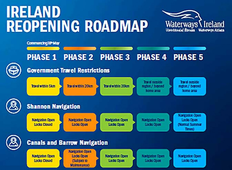
Waterways Ireland is advising the Shannon Navigation, Shannon-Erne Waterway, Royal Canal, Grand Canal, Barrow Line and Navigation of the following roadmap for reopening of the navigations:
Navigational Use
It is important to understand that it will take time to fully open all navigations. It requires the introduction of new COVID-19 procedures and protocols for compliance with Health and Safety legislation. This involves the management and mitigation of risk, training of staff and provision of resources for the protection of staff and waterway users. We ask all our boaters to continue to observe the regulations.
WI advise users on our ROI navigations that:
Locks on the Shannon Navigation, Shannon-Erne Waterway, Royal Canal, Grand Canal, Barrow Line and Navigation will reopen on 8th June 2020.
- Winter mooring facilities have been further extended until 20th July 2020 in order to ease the pressure on our boating community. Boaters do not need to travel to move their vessel. There will be no additional cost for this extension;
- Navigation is open within 5km of your home. All Waterways Ireland service blocks are closed.
- Travel in excess of 5km (ROI only) from your home to check on vessels moored on the navigation is prohibited until further notice;
- Our towpaths remain open and accessible for local exercise. We are however asking users of our canal towpaths to limit their use, and only use towpaths which are in close vicinity (5km in ROI) of your home.

GENERAL GUIDELINES (ALL NAVIGATIONS);
Navigations:
- Electricity and water services have been reconnected;
- Normal pump-out facilities are available for boaters. Owners must ensure that travel to pump-out facilities must be undertaken in a responsible manner, minimising the amount of essential movement out on the water;
- When on jetties please be aware of other users. Wait or move aside to allow others to pass at a safe distance.
- All Waterways Ireland service blocks are closed.
Canal Towpaths and walks
Our plea to everyone thinking of using our towpaths is:
- Observe social distancing protocols - keep a distance of at least 2m (6 feet) away from other people;
- Use the towpaths for brief physical exercise only;
- Limit use – do not take part in physical activity on towpaths which have the potential for large numbers, where social distancing cannot be observed comfortably;
- Up to four people not of same household can meet outdoors while maintaining strict social distancing ;
- Stay local to your home (5km ROI only);
- As towpaths in some places can be narrow, when you pass someone, please make sure you use the full width of the towpath, keep moving, and stand aside to allow others to pass, in single file, when necessary;
- If you can't avoid passing a moored boat please keep as far away from it as possible and pass quickly by;
- Be mindful of others and act always with consideration and with respect and observe the leave no trace principles and protect our environment;
- Observe all health etiquettes when on the towpaths.
In all instances, social distancing must be maintained at all times keeping your distance from both other people and moored boats. Please refer to your relevant representative body for guidance on the most appropriate health and safety precautions and advice.
WI recognise the situation is constantly changing and we ask for your patience during this time. Any updates to the situation will be communicated via the issuance of Marine Notices, through our Waterways Ireland Social Media channels and website.
While our staff are working from home, they are available by phone during normal working hours. Should you need our assistance please contact by email at [email protected] or by phone https://www.waterwaysireland.org/contact-us.
Renewed Calls for Single Management Agency for River Shannon
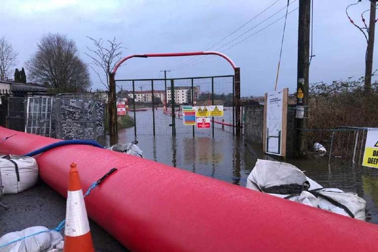
As Storm Jorge swept in from the Atlantic, there have been renewed calls a single river management agency for the Shannon.
Farmers and residents along the river can no longer cope with “despair” and constant fear of flooding, Mid-Shannon flood relief group chairman Michael Silke told The Sunday Times.
Some farmers have experienced up to six serious flooding instances in 25 years, he pointed out.
“These are people who were told during floods in 2009 that this was a one in a hundred-year event – clearly not true when we had a recurrence in 2016 and now,” Mr Silke said
If one Shannon management agency was established, bogland could be used as a natural “sponge” to relieve pressure along critical stretches, Mr Silke told The Sunday Times.
Mr Silke said that half of his own beef and sheep farm has been covered in water since last week, but emphasised that many of his neighbours in the Shannon area were in a far worse situation, with flooding in homes, yards and across swathes of land.
“Leaving the Shannon to the ESB, Waterways Ireland and Office of Public Works (OPW) to manage it is not working,” he said.
However, the OPW approach and its Catchment Flood Risk Assessment and Management (CFRAM) work was defended yesterday by outgoing Minister of State for the OPW Kevin “Boxer” Moran on RTÉ Radio.
In Galway, harbourmaster Capt Brian Sheridan said that “joined-up thinking” was also required for management of severe weather events on the Atlantic seaboard.
“Galway city has dodged a bullet again this weekend, only because the peak of the storm coincides with low tide,” Capt Sheridan said.
“Met Éireann provides a great service, but we need more geographically specific real-time information,” he said. For more, read The Sunday Times report here

#biodiversity – Students from Kilfinane National School gathered along the banks of the River Loobagh in Limerick yesterday (Monday) as part of a new environmental education initiative being administered by Limerick City & County Council.
'StreamScapes Loobagh' is aimed at promoting the aquatic and biodiversity resources of the River Loobagh Catchment in south County Limerick.
The visit by the school children was followed later in the day by a visit to the river by members of the local community. The Kilfinane event is one of three taking place over the coming weeks with others scheduled for Ardpatrick on Monday 11th May and Kilmallock on Monday 18th May.
"The children and their teachers really enjoyed their exploration of the River Loobagh this week. Amongst the interesting wildlife species identified and documented on the stretch of river by the Well Road were salmon and trout fry, juvenile glass eel, or "elvers", - all the way from the Saragossa Sea - and crayfish. They also found a range of stonefly and mayfly nymphs and cased caddis fly larvae which points towards a very high quality river environment at that location," said Anne Goggin, Senior Executive Engineer with Limerick City and County Council.
"We are utilising the award-winning 'StreamScapes' programme to enable communities of the River Loobagh to learn about the important links between high status local water quality and human health, thriving socio-economy, higher value agricultural produce and biodiversity. We are excited to be producing this programme and encourage people to engage," added Ms. Goggin.
The initiative is backed up by a dedicated local environmental booklet which is being distributed to communities in the Loobagh catchment area.
Upcoming Community Evenings:
- Mon 11th May, Ardpatrick: meet at 7pm in church car park. Visit to river followed by meeting and refreshments in the community hall.
- Mon 18th May Kilmallock: meet at 7pm in Car Park of Deebert House Hotel. Visit to river followed by meeting and refreshments afterwards in the hotel.
Lough Derg Trail Showcases Natural Heritage Treasures

#loughderg – A new trail showcasing the rich natural heritage of Lough Derg has been developed in time for the 2015 summer season.
Lough Derg (on the Shannon) Nature Trail is produced by the County Councils in Clare, Galway and Tipperary, and co-funded by The Heritage Council and Lakelands & Inland Waterways.
The 130-kilometre trail takes visitors from Portumna in Galway down the western shore of the lake, to Killaloe in Clare, and back up on the eastern side to Terryglass in Tipperary. The stops along the route, which can be travelled in any direction, include walking routes, lakeshore access, great bird watching locations, woodland parks for adventuring, and quiet spots to enjoy the beautiful vistas of Ireland's third largest lake and the largest lake in the River Shannon system.
Among the 24 discovery points featured is the monastic site at Inis Cealtra - known as the "Jewel of the Lough' - as well as the ancient woodlands of Portumna Forest Park, Derrycrag Wood, Raheen Wood and Cominchas Forest, the sheltered bays and harbours at Rosmore, Mountshannon and Garrykennedy, and the twin heritage towns of Killaloe-Ballina.
Speaking ahead of the trail launch in Portumna this Thursday, Cllr. Mary Hoade, Cathaoirleach of Galway County Council, who said "the outstanding natural heritage of Lough Derg enhances the visitor experience by providing a range of vistas, sights, sounds and places to explore and opportunities to experience, many of which are featured in this wonderful new trail."
"The high level of involvement from communities around Lough Derg in the design and content of this trail has been instrumental in its development, and is reflective of the community-centred approach to protecting the environment and promoting tourism around the Lough Derg region. I am confident this new trail will deliver additional visitors to Lough Derg, as well as economic benefits for the wider local community and tourism sector here in the Lough Derg Region," added the Cathaoirleach.
Each of the discovery sites selected for inclusion in the Lough Derg Nature Trail featured in the Natural Heritage Audit of Lough Derg (on the Shannon) produced by Dr Allan Mee and Shane O'Neill and written by Dr. Janice Fuller. The trail project meanwhile, was directed by the three County Council Heritage Officers in the region, Marie Mannion (Galway), Congella McGuire (Clare) and Roisín O'Grady (Tipperary), and Nuala O'Connell (Senior Executive Planner, Tipperary County Council).
According to Marie Mannion: "Galway County Council, along with the Councils in Clare and Tipperary, are delighted to have played a central role in developing a trail around what is a largely undiscovered natural amenity in the heart of Ireland. This trail provides visitors and locals alike with a continuous guided tour around Lough Derg in the Lough Derg Region taking in some of the best scenery and natural sites that Ireland has to offer."
"Lough Derg is Ireland's premier inland navigation and water sports destination, and is also a paradise for anglers along with being a popular region for bird watching. The lake is fully navigable and has many beautiful harbours and piers for mooring. The diversity of landscapes in the Lough Derg lakelands, coupled with the many hundreds of heritage sites dotted in and around its shoreline make it a wonderfully diverse and enjoyable visitor destination. This trail, which complements the existing Lough Derg Heritage Trail, aims to inform and guide visitors to the region about the many places to experience and enjoy here," added Ms. Mannion.
The new trail will be officially launched at a seminar being held at The Workhouse Centre in Portumna, County Galway, next Thursday, 30th April.
The event will feature presentations by Dr. Alan Mee on the White Tailed Sea Eagles on Lough Derg, consultant ecologist and writer Dr. Janice Fuller on 'Going Wild on the Lough Derg Nature Trail', and Lorcán O'Toole of the Golden Eagle Trust on the effectiveness of existing tourism policies for rural communities.
A detailed guide to accompany the Nature Trail will also be launched on the day.
Sites featured in the Lough Derg (on the Shannon) Nature Trail include Portumna Water Recreation Park, Portumna Forest Park, Abbeyville Golden Mile, Derrycrag Wood, Rosmore Pier (Galway), Coos-East Clare Way, Clare/Galway), Dromaan Harbour at Williamstown, Church Bay, Mountshannon, Inis Cealtra, Woodpark, Raheen Wood, Aughinish Wood, Ballycuggaran Forest & Rinnaman Point (Clare) Killaloe-Ballina (Clare/Tipperary) Castletown (The Lookout), Castlelough Woods, Garrykennedy, Youghal Bay, Ryan's Point, Dromineer Bay, Luska Bay at Coolbaun, Cominchas Forest, and Terryglass (Tipperary).
Copies of the Lough Derg (on the Shannon) Nature Trail and accompany guide will be distributed to tourist offices and visitor attractions around Lough Derg. For more visit www. galwaycoco.ie.
Shannon Navigation Winter Mooring Period Ends on March 31

#inland – Waterways Ireland has reminded masters and owners of vessels that the winter mooring period finishes on the Shannon Navigation which includes the Shannon–Erne Waterway on Tues 31 March.
Inland Fisheries Ireland & Queens University Belfast Share Expertise in Fisheries Research
#fisheries – Inland Fisheries Ireland (IFI) and Queens University Belfast (QUB) jointly sealed a Memorandum of Understanding (MOU) at QUB's Medical Biological Centre earlier this week, on Wednesday 11th of March 2015, expressing their commitment to a continued rich and productive liaison in research and education.
Over a number of years, scientists from QUB and Inland Fisheries Ireland have worked in collaboration to produce high quality research covering an extraordinary range of projects, species and topics. Current areas of joint research include: fish population genetics; aquatic invasive species; and fish telemetry.
Speaking at the announcement, IFI's Head of Research, Dr Cathal Gallagher commented: "IFI and QUB look forward to building on our existing relationship to produce the highest quality research outputs and publications to support the conservation and management on the inland fisheries resource."
The organisations are also seeking to collaborate in encouraging and supporting the development of the next generation of fisheries scientists and technologists.
Dr Cathal Gallagher, continued: "I am confident that the memorandum of understanding signed here today will act as an impetus to move forward with future research collaboration to support our shared goals. I see this collaboration as vital in supporting the development and education of the next generation of scientists into whose hands the future of this resource will be placed.
"I'm also extremely impressed by the expertise and quality of the joint research currently being undertaken and I look forward with anticipation to reviewing the outputs of these projects.'
Professor Christine Maggs, Head of School, School of Biological Sciences, Queen's University Belfast, welcomed the announcement, saying "We are delighted that there is now formal recognition of the long and productive collaboration between QUB and IFI.
"The School's expertise in fish genetics, fish biology and aquatic ecology has been successfully applied to answering significant research questions for the IFI for more than a decade."

#digitalnavigation – Waterways Ireland has developed an Online Navigation Guide for the Lower Bann for use on computers, tablets and mobile phones. In a major step change in the presentation of navigation guides for Ireland's Inland Waterways, Waterways Ireland has, in consultation with user groups, developed, tested and now launched, pilot Online Navigation Guides, designed to provide a convenient alternative to printed navigation guides.
The online guide to navigation has been developed internally within Waterways Ireland using ArcGIS online. This interactive web mapping application details navigation features such as Locks, Moorings, Weirs, Navigation Markers and other facilities along the waterway. These data layers are then overlaid using ArcGIS online web maps. GPS surveys or digitising onscreen using Ordnance Survey Maps have been used to capture the location of features. The application enables the public to pan around the map, identify features, print maps, switch between base mapping & satellite view and switch on and off layers. The Lower Bann Guide is complete and available for free on our website and can be viewed on a PC, Tablet or Smartphone.
Waterways Ireland will update the maps on an ongoing basis so that the latest navigational information is always available online. Ongoing feedback is welcomed from users to keep the mapping information accurate.
With both the Lower Bann and the Erne System Navigation Guides presently available online, Waterways Ireland is commencing work with user groups on the Shannon and will subsequently cover the remaining waterways.
The maps are available here by choosing the waterway and then selected the map tab. To directly access the Lower Bann & Lough Erne Online Navigation Guides, click here
In the initial pilot period, broadband access or a wifi link will be required to use the online navigation guides for the Lower Bann and Erne Systems. Progress is being made on an offline/cached version which will be made available as soon as possible.
It is also planned that the next phase of the Online Navigation Guides will have additional layers of information for waterway & waterside recreational and tourism activity which the user can turn on and off.
In this transition period Waterways Ireland continues to offer a paper product to Waterway users. A comprehensive navigation guide for the Erne System, Shannon-Erne Waterway and Shannon Navigation is for sale at www.shopwaterwaysireland.org for €15/£12.60 and the Lower Bann Guide is also available.
To send feedback by emailing [email protected] including "Online Navigation Guides" in the email title.

#The Carrick-on-Shannon Rowing Regatta will be held on Sunday 3 August 2014 on a 400 metres stretch of water immediately south of the town bridge commencing at 08:00hr and finishing at approx. 18.00hr. Craft wishing to make a through passage will be facilitated every 2 hrs approximately, during the course of the regatta. Mooring restrictions will apply in Carrick-on-Shannon to facilitate the Regatta.
Hundreds of spectators are expected at the event, one of the final events of the season, which is supported by Waterways Ireland through its sponsorship programme.
In the interest of marine safety and to facilitate the laying of the competition course access to the floating moorings will be restricted in the run-up to and during the event itself. Only vessels of an overall length of 22ft. /6.8m or less will be permitted on the floating jetties from Fri 1 to Sunday 3 August. Vessels berthed from Friday 1st 16.00hr will be required to remain in place until racing finishes at approx 18.00hr on Sunday 3 August.
The floating jetties will be closed off on 16.00hr Friday and approx 18.00hr Sunday and manoeuvring room will be severely restricted due to the proximity of the course. As a result no vessels should approach the jetties between these times. Access to the floating jetties will be monitored from Monday 28 July.
Masters are advised to proceed at slow speed and with due caution and to take note of advice from course marshals when passing through the area. Waterways Ireland takes this opportunity to thank its customers for their co-operation with these arrangements.
Further information can be had by contacting Waterways Ireland Inspectorate +353 (0)87 985 2324 or Operations Division North Shannon +353 (0)71 96 50787.
#boathire – In a cost reduction move, two leading Shannon boat hire companies are to merge. Carrickcraft and Waveline Cruisers will be merging for the 2015 boat hire season. The existing shareholders of Carrickcraft and Waveline will be shareholders in the enlarged holding company for the group.
The combined fleet of 125 boats will be based at Carrickcraft's existing marinas at Carrick-on- Shannon and Banagher on the Shannon and at Bellanaleck on Lough Erne. Administration and accounting will be centralised at Carrickcraft's Markethill office.
Sven and Anita Neubert of Waveline have already moved back to live in Germany and will run the German-speaking booking office for the combined group. With their knowledge of this market and the increased fleet, the target is to increase the number of bookings from Germany, Austria and Switzerland.
John Morton, Managing Director of Carrickcraft, said "We have worked well with Sven and Anita on many joint projects and this is a great opportunity for us to increase our business in Europe. We have developed some excellent web-based marketing strategies for the English-speaking market and will now try to do the same for the German-speaking market."
"Consolidation will help us to reduce some costs while maintaining and improving the customer experience. In addition to European Sales, Anita will be focussing on quality control with the full support of the Board."
World Canal Conference to be Staged in Milan

#canal – The 27th World Canals Conference, previously staged in Ireland, will be held at the Lombardy Region 'palace' in Milan from September 1-4. The conference offers a unique opportunity to meet key players in a wide range of developments on canals and rivers, from the smallest canals in historic city centres to high-capacity waterways needed for Europe to maintain her industries and survive world competition.
Italy is at the heart of contemporary trends in both areas, with ground-breaking projects on Milan's historic canals, as well as major investments currently under way or planned on the Ferrara waterway, the river Po and two canals - Venice-Padova and Milan-Cremona-Po - that have been left incomplete for 40 years!


 linking Spain.")


 Michael Murphy Schull Harbour Sailing Club (SHSC), Eric Coogan Heineken Ireland, Mark Murphy, Commodore SHSC, Jack Allen SHSC, Carmel O'Regan SHSC, Cornelious Ndlovu, Schull Harbour Hotel Operations Manager and Derval Murphy SHSC")


