Menu

Ireland's sailing, boating & maritime magazine

Displaying items by tag: marine data buoy

The Minister for Agriculture, Food and the Marine, Minister Creed T.D., has announced an investment of over €0.7m in the Marine Data Buoy Network. The additional funding will provide for both ongoing operations and a significant upgrading of the existing infrastructure.

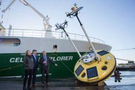
Speaking from the research vessel RV Celtic Explorer, docked in the Port of Cork, Minister for Agriculture, Food and Marine Michael Creed TD said, “I am delighted that the Government has been able to provide significantly increased funding for this vitally important element of our weather and oceanographic observation system. With the impacts of climate change ever more apparent the Government recognizes the importance of increased investment in the existing Marine Data Buoy Network system. This increased expenditure will greatly assist our ocean and weather forecasting capabilities in the years ahead as well as supporting vital climate change research and improving safety at sea. Climate change is one of the greatest challenges facing nations, Governments and decision makers worldwide. With the incidences of extreme weather conditions increasing, the Government’s investment in the Irish Marine Data Buoy Network is very significant but essential. This ongoing and additional funding will enable the Marine Institute to provide essential national services in ocean observation and weather forecasting programmes that have regional and local impact on our livelihoods, safety and the growing blue economy.”

The Marine Data Buoy Network is managed by the Marine Institute in collaboration with Met Eireann. The Network provides crucial data for weather forecasting, risk management for shipping, the fishing community and coastal towns and villages with advanced warnings as well as oceanography research and data on Ireland’s deep waters. This additional injection of €300,000 brings the total investment to over €700,000 for the network in 2018. This investment will enable the upgrade of the Network with new generation buoy platforms and a suite of sensors, replacing the current technology that has been in use since 2008. Dr Peter Heffernan, CEO of the Marine Institute, speaking at the launch said; “Investment in the observation buoys and other infrastructures and research capacities will enable Ireland to be at the forefront in providing critical research capacity and overcoming infrastructure gaps that, in the past, have reduced our ability to address questions of national and global importance with respect to climate and ocean change,”.

During hurricane Ophelia in 2017, waves were recorded at a maximum height of 17.8 meters by the M5 weather buoy off the southeast coast. In 2011, the M4 weather buoy, located 75km north of Belmullet on the northwest coast of Ireland, recorded the largest waves recorded in Irish waters, reaching a maximum height of 20.4 meters. The most westerly buoy, M6, located hundreds of kilometres to the west of Ireland, is a sentinel buoy that gathers critical early data reported hourly on weather approaching Ireland and Europe from the Atlantic. The data buoys provide vital information on atmospheric and sea conditions that influence Ireland’s weather such as atmospheric pressure, air and sea temperature, wind speed and direction. This information helps to validate the weather forecasting models run by Met Éireann, that can, in turn, provide guidance to the national emergency planning efforts during the extreme weather events. 

Evelyn Cusack Head of Forecasting from Met Éireann who also attended the launch said; “The data buoys provide vital information about our weather such as atmospheric pressure, air and sea temperature, wind speed and direction. This information is used in the weather forecasting models run by Met Éireann, that provides guidance to the national emergency planning efforts during extreme weather events including storms such as Ophelia and Emma.”

Lord Mayor of Cork, Councillor Mick Finn highlighted the importance of the weather buoy infrastructures to local communities. Mayor Finn stated “As an island nation, the data provided by the buoys is particularly important for communities, coastal and inland, where impending storms may have serious knock-on impacts on local economies. The investment in this technology serves to both warn in the short term while informing over the long-term forecasts. This will help planning for future-proofed protection and safety measures to reduce damage and losses to businesses and infrastructure,” he said.

Minister Creed also welcomed the significant progress made by the Marine Institute in implementing its Strategic Plan, Building Ocean Knowledge, Delivering Ocean Services (2018-2022). Minister Creed stated “Initiatives by the Institute in enhancing the area of research in forecasting ocean and climate change, places Ireland in a unique position to better understand and contribute to national climate adaptation as well as international climate policy. Increasing Ireland’s scientific research capacity in key areas such as sea level change, ocean circulation, and carbon sequestration, is essential and has been highlighted in the Galway Statement on Atlantic Cooperation; the emerging European Ocean Observing System (EOOS) and the Atlantic Ocean Observing System (AtlantOS). The continued investment in the Marine Data Buoy Network will further contribute to building Ireland’s national capacity in physical oceanography and ocean climate science. The ongoing investment targets capacity building, and delivery of relevant knowledge aimed at better understanding the complex interactions between the ocean and climate change is welcomed”

Published in Marine Science
Tagged under

#DUBLIN BAY – Dublin Bay Sailing Club (DBSC) Racing yachts have been asked by race organisers to give a marine data buoy stationed in Scotsman's Bay (Latitude: 53 17.51 N Longitude 006 07.00) a wide berth even though it may be on some DBSC race courses this season.

The buoy carries a lot of expensive research equipment and It's on the periphery of the Red fleet's Thursday courses and also the dinghy Tuesday evening courses.

A combined fleet of 300 boats race under the DBSC burgee on Tuesday, Thursday, Saturday and Sundays making the yachts the biggest leisure users of bay waters.

Competing boats might possibly meet the yellow buoy if on a port-hand tack when sailing a beat from 40 ft. mark to Bay Mark and vice versa.

Published in DBSC

Dun Laoghaire Harbour Information

Dun Laoghaire Harbour is the second port for Dublin and is located on the south shore of Dublin Bay. Marine uses for this 200-year-old man-made harbour have changed over its lifetime. Originally built as a port of refuge for sailing ships entering the narrow channel at Dublin Port, the harbour has had a continuous ferry link with Wales, and this was the principal activity of the harbour until the service stopped in 2015. In all this time, however, one thing has remained constant, and that is the popularity of sailing and boating from the port, making it Ireland's marine leisure capital with a harbour fleet of between 1,200 -1,600 pleasure craft based at the country's largest marina (800 berths) and its four waterfront yacht clubs.

Dun Laoghaire Harbour Bye-Laws

Download the bye-laws on this link here

FAQs

A live stream Dublin Bay webcam showing Dun Laoghaire Harbour entrance and East Pier is here

Dun Laoghaire is a Dublin suburb situated on the south side of Dublin Bay, approximately, 15km from Dublin city centre.

The east and west piers of the harbour are each of 1 kilometre (0.62 miles) long.

The harbour entrance is 232 metres (761 ft) across from East to West Pier.

  • Public Boatyard
  • Public slipway
  • Public Marina

23 clubs, 14 activity providers and eight state-related organisations operate from Dun Laoghaire Harbour that facilitates a full range of sports - Sailing, Rowing, Diving, Windsurfing, Angling, Canoeing, Swimming, Triathlon, Powerboating, Kayaking and Paddleboarding. Participants include members of the public, club members, tourists, disabled, disadvantaged, event competitors, schools, youth groups and college students.

  • Commissioners of Irish Lights
  • Dun Laoghaire Marina
  • MGM Boats & Boatyard
  • Coastguard
  • Naval Service Reserve
  • Royal National Lifeboat Institution
  • Marine Activity Centre
  • Rowing clubs
  • Yachting and Sailing Clubs
  • Sailing Schools
  • Irish Olympic Sailing Team
  • Chandlery & Boat Supply Stores

The east and west granite-built piers of Dun Laoghaire harbour are each of one kilometre (0.62 mi) long and enclose an area of 250 acres (1.0 km2) with the harbour entrance being 232 metres (761 ft) in width.

In 2018, the ownership of the great granite was transferred in its entirety to Dun Laoghaire Rathdown County Council who now operate and manage the harbour. Prior to that, the harbour was operated by The Dun Laoghaire Harbour Company, a state company, dissolved in 2018 under the Ports Act.

  • 1817 - Construction of the East Pier to a design by John Rennie began in 1817 with Earl Whitworth Lord Lieutenant of Ireland laying the first stone.
  • 1820 - Rennie had concerns a single pier would be subject to silting, and by 1820 gained support for the construction of the West pier to begin shortly afterwards. When King George IV left Ireland from the harbour in 1820, Dunleary was renamed Kingstown, a name that was to remain in use for nearly 100 years. The harbour was named the Royal Harbour of George the Fourth which seems not to have remained for so long.
  • 1824 - saw over 3,000 boats shelter in the partially completed harbour, but it also saw the beginning of operations off the North Wall which alleviated many of the issues ships were having accessing Dublin Port.
  • 1826 - Kingstown harbour gained the important mail packet service which at the time was under the stewardship of the Admiralty with a wharf completed on the East Pier in the following year. The service was transferred from Howth whose harbour had suffered from silting and the need for frequent dredging.
  • 1831 - Royal Irish Yacht Club founded
  • 1837 - saw the creation of Victoria Wharf, since renamed St. Michael's Wharf with the D&KR extended and a new terminus created convenient to the wharf.[8] The extended line had cut a chord across the old harbour with the landward pool so created later filled in.
  • 1838 - Royal St George Yacht Club founded
  • 1842 - By this time the largest man-made harbour in Western Europe had been completed with the construction of the East Pier lighthouse.
  • 1855 - The harbour was further enhanced by the completion of Traders Wharf in 1855 and Carlisle Pier in 1856. The mid-1850s also saw the completion of the West Pier lighthouse. The railway was connected to Bray in 1856
  • 1871 - National Yacht Club founded
  • 1884 - Dublin Bay Sailing Club founded
  • 1918 - The Mailboat, “The RMS Leinster” sailed out of Dún Laoghaire with 685 people on board. 22 were post office workers sorting the mail; 70 were crew and the vast majority of the passengers were soldiers returning to the battlefields of World War I. The ship was torpedoed by a German U-boat near the Kish lighthouse killing many of those onboard.
  • 1920 - Kingstown reverted to the name Dún Laoghaire in 1920 and in 1924 the harbour was officially renamed "Dun Laoghaire Harbour"
  • 1944 - a diaphone fog signal was installed at the East Pier
  • 1965 - Dun Laoghaire Motor Yacht Club founded
  • 1968 - The East Pier lighthouse station switched from vapourised paraffin to electricity, and became unmanned. The new candle-power was 226,000
  • 1977- A flying boat landed in Dun Laoghaire Harbour, one of the most unusual visitors
  • 1978 - Irish National Sailing School founded
  • 1934 - saw the Dublin and Kingstown Railway begin operations from their terminus at Westland Row to a terminus at the West Pier which began at the old harbour
  • 2001 - Dun Laoghaire Marina opens with 500 berths
  • 2015 - Ferry services cease bringing to an end a 200-year continuous link with Wales.
  • 2017- Bicentenary celebrations and time capsule laid.
  • 2018 - Dun Laoghaire Harbour Company dissolved, the harbour is transferred into the hands of Dun Laoghaire Rathdown County Council

From East pier to West Pier the waterfront clubs are:

  • National Yacht Club. Read latest NYC news here
  • Royal St. George Yacht Club. Read latest RSTGYC news here
  • Royal Irish Yacht Club. Read latest RIYC news here
  • Dun Laoghaire Motor Yacht Club. Read latest DMYC news here


The umbrella organisation that organises weekly racing in summer and winter on Dublin Bay for all the yacht clubs is Dublin Bay Sailing Club. It has no clubhouse of its own but operates through the clubs with two x Committee vessels and a starters hut on the West Pier. Read the latest DBSC news here.

The sailing community is a key stakeholder in Dún Laoghaire. The clubs attract many visitors from home and abroad and attract major international sailing events to the harbour.


Dun Laoghaire Regatta

Dun Laoghaire's biennial town regatta was started in 2005 as a joint cooperation by the town's major yacht clubs. It was an immediate success and is now in its eighth edition and has become Ireland's biggest sailing event. The combined club's regatta is held in the first week of July.

  • Attracts 500 boats and more from overseas and around the country
  • Four-day championship involving 2,500 sailors with supporting family and friends
  • Economic study carried out by the Irish Marine Federation estimated the economic value of the 2009 Regatta at €2.5 million

The dates for the 2021 edition of Ireland's biggest sailing event on Dublin Bay is: 8-11 July 2021. More details here

Dun Laoghaire-Dingle Offshore Race

The biennial Dun Laoghaire to Dingle race is a 320-miles race down the East coast of Ireland, across the south coast and into Dingle harbour in County Kerry. The latest news on the Dun Laoghaire to Dingle Race can be found by clicking on the link here. The race is organised by the National Yacht Club.

The 2021 Race will start from the National Yacht Club on Wednesday 9th, June 2021.

Round Ireland Yacht Race

This is a Wicklow Sailing Club race but in 2013 the Garden County Club made an arrangement that sees see entries berthed at the RIYC in Dun Laoghaire Harbour for scrutineering prior to the biennial 704–mile race start off Wicklow harbour. Larger boats have been unable to berth in the confines of Wicklow harbour, a factor WSC believes has restricted the growth of the Round Ireland fleet. 'It means we can now encourage larger boats that have shown an interest in competing but we have been unable to cater for in Wicklow' harbour, WSC Commodore Peter Shearer told Afloat.ie here. The race also holds a pre-ace launch party at the Royal Irish Yacht Club.

Laser Masters World Championship 2018

  • 301 boats from 25 nations

Laser Radial World Championship 2016

  • 436 competitors from 48 nations

ISAF Youth Worlds 2012

  • The Youth Olympics of Sailing run on behalf of World Sailing in 2012.
  • Two-week event attracting 61 nations, 255 boats, 450 volunteers.
  • Generated 9,000 bed nights and valued at €9 million to the local economy.

The Harbour Police are authorised by the company to police the harbour and to enforce and implement bye-laws within the harbour, and all regulations made by the company in relation to the harbour.

There are four ship/ferry berths in Dun Laoghaire:

  • No 1 berth (East Pier)
  • No 2 berth (east side of Carlisle Pier)
  • No 3 berth (west side of Carlisle Pier)
  • No 4 berth  (St, Michaels Wharf)

Berthing facilities for smaller craft exist in the town's 800-berth marina and on swinging moorings.

© Afloat 2020