


Displaying items by tag: RV Celtic Explorer
#ClimateChange - Preliminary results from the recent ‘health check’ of the Atlantic Ocean suggest a greater penetration of manmade chlorofluorocarbons (CFCs) further into the deeper ocean since 20 years ago.
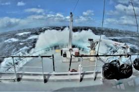
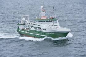
As previously reported on Afloat.ie, an Irish-led international team of marine scientists from six countries set out from Newfoundland on 27 April on board the RV Celtic Explorer, to survey a transect of the Atlantic last measured two decades ago and investigate the impact of climate change on the deep ocean.
Explaining the team’s findings, Dr Evin McGovern of the Marine Institute and principal investigator on the GO-SHIP A02 survey said: “Although these chemicals have been phased out, they remain in the atmosphere and enter the ocean, where over time, they travel to the deep ocean.
“We measure the CFCs to tell the age of the water masses in the deep ocean and this helps us assess the uptake of fossil fuel carbon from the atmosphere and penetration into the deep ocean.”
The survey formed part of the Global Oceans Ship-Based Hydrographic Investigations Programme (GO-SHIP), which carries out systematic and global surveys of select hydrographic sections, through an international consortium of 16 countries and laboratories.
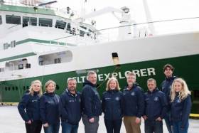
This was the first GO-SHIP survey to involve such a level of collaboration, with scientists from 10 leading universities and research institutes representing six countries.
Canadian Ambassador to Ireland Kevin Vickers visited the RV Celtic Explorer to meet the team in Galway following their arrival on Monday 22 May.
“This survey is a wonderful example of the Galway Statement in action as well as the longstanding collaboration on marine research between Ireland and Canada,” he said.
Marine Institute chief executive Dr Peter Heffernan added that the expedition’s scientists “are contributing to addressing some of the biggest questions for society and our interaction with our planet.”
Find out more about the survey on the Scientists@Sea blog, where the GO-SHIP team aboard the RV Celtic Explorer recorded their work and experiences.
Six Countries Team Up To Take Temperature Of The Atlantic
#MarineScience - An international team of marine scientists from six countries are currently sailing on Ireland’s national research vessel RV Celtic Explorer on a transatlantic voyage to study the impact of climate change on the ocean.
Departing from St John’s in Newfoundland on Thursday 27 April — after launching the miniature yacht Lancer a few days previously — and due to arrive in Galway on 23 May, the Marine Institute-led team of experts are surveying a transect of the Atlantic Ocean last surveyed 20 years ago to investigate carbon dioxide levels in the ocean.
The survey is essential to understand and project how carbon dioxide emissions are accumulated in the oceans and the atmosphere, as well as its effects on the acidification of the ocean.
The survey is part of the Global Oceans Ship-Based Hydrographic Investigations Program (GO-SHIP), which carries out systematic and global surveys of select hydrographic sections, through an international consortium of 16 countries and laboratories.
This is the first GO-SHIP survey to involve this level of collaboration with scientists from ten leading universities and research institutes representing six countries joining the survey.
Marine Institute chief executive Dr Peter Heffernan said: “The Marine Institute is proud to lead this truly international collaboration. This GO-SHIP A02 survey is a very real example of the Galway Statement in action: working together to better understand and increase our knowledge of the Atlantic Ocean and its dynamic systems, and promoting the sustainable management of its resources.”
The Galway Statement, signed at the Marine Institute 24 May 2013, launched the Atlantic Ocean Research Alliance between the EU, Canada and the USA.
The survey is co-ordinated by the Marine Institute and NUI Galway with research partners in Dalhousie University and Fisheries and Oceans, Canada; University of Exeter, United Kingdom; GEOMAR, Germany; Woods Hole Oceanographic Institution and Columbia University, USA; and Aarhus University, Denmark.
“Ship-based surveys are still the only way to collect the best quality measurements of fundamental physical, chemical and biological properties known as Essential Ocean Variables,” said Dr Evin McGovern of the Marine Institute and principal investigator on the GO-SHIP A02 survey.
“Although technology has provided many new methods to collect ocean measurements, there’s really no substitute for going out on the ocean on a research vessel.
“We can use satellite technology to look at certain properties the ocean surface and can deploy autonomous argo floats to take some measurements to depths of 2000, but we need to carry out ocean surveys that can measure to get a complete picture of the chemistry of the ocean at different depths up to 5,000m.
“The transect we are surveying is a really dynamic area of the Atlantic for heat transport and carbon uptake and is hugely important to informing our understanding of our global climate and how the ocean regulates our climate,” added Dr McGovern.
“The Northwest Atlantic is one of the world’s largest sinks of carbon dioxide and despite progress in our understanding there’s still a huge lack of data as it relates to climate change’s impact on the ocean and what that means for the economy and society,” said Brad de Young, a professor of physics and physical oceanography at Memorial University, Newfoundland and an Ocean Frontier Institute researcher.
“Improving our scientific understanding and developing strategic and effective solutions for safe and sustainable ocean development requires sharing of expertise, international co-operation and exchange of data and best practices. And that’s what this voyage is all about,” adds Doug Wallace, Canada Excellence research chair at Dalhousie University.
Miniature Yacht Lancer Successfully Launched In Atlantic
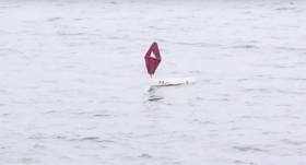
#Lancer - The Marine Institute has posted video of the successful launch of the unmanned yacht Lancer in the Atlantic this past weekend.
The miniature marine research vessel was released from the RV Celtic Explorer on Saturday 22 April in the middle of the Atlantic, in the hopes of it catching either the Irminger current (to take it north towards Greenland) or the Canary current (to carry it southwards towards Africa).
According to the most recent fix via the online GPS tracker, Lancer indeed appears to be headed north to continue its mission.
As previously reported on Afloat.ie, the boat was seen off from Galway by Méabh Ní Ghionnáin, who found the vessel beached near her home in Connemara last September.
The eight-year-old since met with Kaitlyn Dow, the Connecticut high schooler who launched the vessel as part of a year-long science project studying ocean winds and currents.
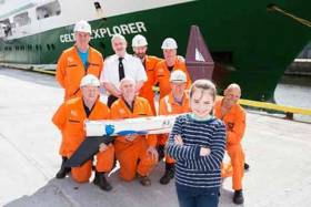
Méabh Ní Ghionnáin from Droim, Leitir Móir, Galway met with the Marine Institute’s scientists and crew on the RV Celtic Explorer today on her 9th birthday (18th April) to see the loading of the 1 ½ metre Lancer unmanned sailboat onto the research vessel, where it will be deployed into the middle of the Atlantic ocean during its transatlantic voyage to St John’s, Newfoundland and Labrador.
As Afloat.ie previously reported, nine months ago, in September 2016, Méabh found the Lancer boat washed ashore on her local beach after it had travelled across the Atlantic as part of a year-long research project that 18 year old Kaitlyn Dow from Connecticut, USA had undertaken. Kaitlyn had launched the boat from the USA National Oceanic and Atmospheric Administration (NOAA) research ship called the Neil Armstrong off the coast of Cape Cod earlier in May 2016. The boat was fitted with a GPS tracker and she studied its movements across the north Atlantic.
The boat successfully crossed the Atlantic on its own following the winds and currents to Ireland, and was eventually washed ashore in the Conamara County Galway, where it was found by Méabh Ní Ghionnáin, a resident of Droim, Leitir Móir. The Lancer Boat has since been repaired by Ciaran Oliver and James Rattigan from Port of Galway Sea Scouts and it is now going to be relaunched from the Marine Institute’s research vessel RV Celtic Explorer on its voyage across the North Atlantic.
Dr Margret Rae, of the Marine Institute’s and the Manager of the Canadian-EU-USA Atlantic Ocean Research Alliance (AORA-CSA), explained that the crew will deploy the Lancer boat on the 22nd April from the RV Celtic Explorer during its nine day voyage. “We hope the unmanned Lancer boat will catch the Irminger current and take it northwards towards Greenland, or the Canary current and take it southwards towards Africa.” The Irminger Current is a north Atlantic ocean current setting westward off the southwest coast of Iceland and can be tracked using the GPS at: http://www.nefsc.noaa.gov/drifter/drift_whs_2016_1.html
“It is also likely that we will get to see more of the mini boats like the Lancer landing in Ireland over the coming year. The transatlantic funded programme AORA-CSA formed a partnership in 2016 with Dick Baldwin’s Educational Passages mini-sailboats in the USA, and together are running an Atlantic Mini-boat Regatta: ‘Around the Atlantic – Our Shared Resource’. The project aims to further promote ocean literacy recognising the importance of the ocean and how it has an impact on our daily lives,” said Dr Rae.
AORA-CSA aims to promote the understanding of the value of the Atlantic Ocean by promoting transatlantic international marine research cooperation – all stemming from the historic Galway Statement on Atlantic Ocean Cooperation signed in Galway, Ireland in 2013. “Stories like Meabh and Kaitlan’s is a wonderful example of both marine science literacy and citizen engagement with the oceans – themes which are a priority for the Atlantic Ocean Research Alliance between Canada, the EU and USA. Seeing new friendships formed across the Atlantic at an early age highlights the value of international partnerships that are essential for sharing marine science” said Dr Heffernan, CEO of the Marine Institute.
With the Atlantic being the second largest ocean in the world, it is important to increase our awareness of the value, opportunities and societal benefits the ocean provides us," Dr Heffernan further said.The Atlantic Mini-boat Regatta is an exciting international demonstration of how results of ocean science and observation address pressing issues facing our citizens, the environment and the world and help to foster public understanding of the value of the Atlantic Ocean.
The research vessel RV Celtic Explorer is leaving from Galway on a transatlantic voyage to St John’s, Newfoundland and Labrador where it will be testing new equipment for multi-beam mapping of the seabed in the middle of the Atlantic as part of the transatlantic AORA-CSA project. On the Research Vessels voyage back to Galway the Marine Institute and NUIGalway will be leading a team of international scientists completing a month transatlantic ocean climate survey – GOSHIP (Global Oceans Ship-Based Hydrographic Investigations Program), learning more about climate change and its impact on the ocean.
The GO-SHIP involves the Marine Institute Ireland, with NUIGalway and research partners in UK, Germany, Canada and the US, and is another important example of the transatlantic collaboration promoted by the Atlantic Ocean Research Alliance between the EU, Canada and the USA
Marine Notice: Annual Groundfish Survey Off South & West Coasts
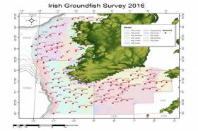
#MarineNotice - The Marine Institute advises that the annual Irish Groundfish Survey (IGFS2016) will be carried out off the South and West coasts of Ireland between Monday 14 November and Sunday 18 December in fulfilment of Ireland’s Common Fisheries Policy obligations.
The IGFS is a demersal trawl survey consisting of a minimum of 125 fishing hauls of 30 minutes duration each. Fishing in 2016 will take place within a 2nm radius of the positions indicated in Marine Notice 44 of 2016, available to read or download HERE.
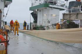
The survey will be conducted by the RV Celtic Explorer (Callsign EIGB), which will display all appropriate lights and signals during the survey and will also be listening on VHF Channel 16. The vessel will be towing a high headline GOV 36/47 demersal trawl during fishing operations.
The Marine Institute requests that commercial fishing and other marine operators keep a 2nm area around the tow points clear of any gear or apparatus during the survey period.
While there is no statutory provision for the loss of gear at sea, the Marine Institute will make every effort to avoid gear adequately marked according to legislation that may be encountered in the notified areas.
In the event that an operator has static gear or other obstructions within 2nm of the points listed above it is the responsibility of the owner to notify the survey managers or vessel directly. This should be communicated by identifying specifically which ‘Prime Station’ is of concern using the appendix and contact details provided in the Marine Notice. It is not required to provide positional details of commercial operations beyond 3-4nm of the survey points provided.
Specifics of any fishing gear or other obstructions that are known and cannot be kept clear of these survey haul locations can be notified using the contact details provided in the Marine Notice.
Annual Irish Groundfish Survey Now Under Way
#Fishing - The Marine Institute’s annual Irish Groundfish Survey (IGFS2016) began off the North West Coast on Sunday 25 September, continuing till Thursday 6 October, in fulfilment of Ireland’s Common Fisheries Policy obligations.
IGFS2016 is a demersal trawl survey consisting of a minimum of 45 fishing hauls each of 30 minutes’ duration. Fishing in 2016 is taking place within a two-nautical-mile radius of positions indicated in Marine Notice No 41 of 2016, available to read or download HERE.
The survey is being conducted by the RV Celtic Explorer (Callsign EIGB), which will display all appropriate lights and signals throughout and is also listening on VHF Channel 16.
The Celtic Explorer will be towing a high headline GOV 36/47 demersal trawl during fishing operations. The Marine Institute requests that commercial fishing and other marine operators keep a two-nautical-mile area around the tow points clear of any gear or apparatus during the survey period outlined above.
While there is no statutory provision for the loss of gear at sea, the Marine Institute will make every effort to avoid gear adequately marked according to legislation that may be encountered in the notified areas.
In the event that an operator has static gear or other obstructions within 2nmi of the haul points, it is the responsibility of the owner to notify the survey managers or vessel directly.
This should be communicated by identifying specifically which ‘Prime Station’ is of concern using the appendix and contact details provided.
It is not required to provide positional details of commercial operations beyond 3-4nmi of the survey points provided. Specifics of any fishing gear or other obstructions that are known and cannot be kept clear of these survey haul locations can be notified using the contact details provided in the Marine Notice.
Marine Institute Hosts Ocean Explorers at Oranmore
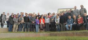
The Marine Institute held the second bi-annual research vessel users conference today at its headquarters in Oranmore, Galway to discuss the vast range of capabilities of both the RV Celtic Explorer and RV Celtic Voyager after their 2015 refits, as well as the use of the remotely operated vehicle, ROV Holland 1.
Director Mick Gillooly of Ocean Science and Information Services, Marine Institute, welcomed the attendance of over 70 marine scientists and researchers who will go to sea on the national research vessels this year. He said: “The demand for survey time on the national research vessels and the quality marine research being carried out across the country shows that Ireland’s scientists are answering the call to better understand our oceans.”
“At a time when we can all see the impacts of climate change, it’s more important than ever to carry out research at sea, including oceanography, fisheries, and environmental monitoring.”
The conference provided information about using high resolution multi-beam mapping, the capabilities of the ROV Holland 1 on surveys as well as key speaker’s experiences using the equipment.
Dr Florian Le Pape of the Dublin Institute for Advanced Studies (DIAS) spoke about the deployment of an Ocean Bottom Seismometer (OBS) network off the Irish shelf as far as the Rockall Trough. Dr Le Pape recently deployed 10 Broad Band OBSs from the RV Celtic Explorer as part of an innovative research program between DIAS, the Helmholtz Centre GFZ Potsdam, Germany and instruments provided by the Alfred Wegener Institute, Germany, which uses the noise from ocean waves to generate seismic images of the earth’s crust.
Over 70 marine scientists attended the Research Vessel Users Conference at the Marine Institute. Deep sea mud volcanoes off the gulf of Cadiz and the high resolution multi-beam mapping of World War 1 shipwrecks in the Irish Sea highlighted the advanced capabilities of the research vessels for deep sea exploration.
The workshop was organised by the Marine Institute’s research vessel operations team also highlighted the value of ship time. Mr Aodhan Fitzgerald, Research Vessel Operations Manager, spoke about the future vessel availability, the ship-time competition for 2017, and how to prepare a strong research survey proposal.
The Marine Institute’s ship-time programme will provide €3 million funding in 2016 supporting 256 research days onboard the national research vessels, RV Celtic Explorer and RV Celtic Voyager. The programme gives researchers access to the national research vessels, as well as the remotely operated submarine ROV Holland I to carry out surveys that further our understanding of the ocean, support policy and development, as well as providing essential training to young researchers and undergraduates.
The programme is part of a busy schedule of research vessel programmes that includes statutory fish stock assessment, environmental monitoring, and seabed mapping surveys in Irish Waters and across the Atlantic basin to Newfoundland.
You can follow the surveys of the research vessels on the blog http://scientistsatsea.blogspot.ie where scientist on-board the national research vessels blog about their research at sea
Blue Whiting Acoustic Survey Begins For 2016
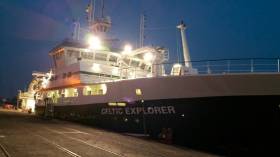
#MarineScience - Marine scientists on board the RV Celtic Explorer have posted their first blog entry from this year's blue whiting acoustic survey voyage.
Setting sail from Cork on St Patrick's Day last week, the team – comprising acousticians, biologists and marine wildlife observers – are preparing to cover a massive area between the West of Ireland and the west coast of Scotland, including Rockall, as part of a flotilla of international research vessels from the Netherlands, Norway and the Faroe Islands.
Research Vessel Users Workshop In April
#MarineScience - The research vessel operations team at the Marine Institute are hosting a workshop for research vessel users at the institute's Oranmore headquarters on Thursday 28 April.
The aim of the workshop is to give marine scientists across a range of disciplines the opportunity to discuss their research, and their experience on both the RV Celtic Explorer and RV Celtic Voyager, as well as using the ROV Holland 1.
It will also allow the research vessel operations team to highlight the capabilities of both research vessels post 2015 refits, and to gather feedback about how the service could be improved.
The meeting will commence at 9am and it is planned to finish at 6pm. There will be an opportunity to have a Q&A session around the talks and gather feedback from both the user and the service provider. Contact [email protected] with any queries.
The research vessel users workshop will be followed by a SMARTSkills day workshop also in Oranmore on Friday 29 April with training sessions on the following:
- MaxSea plotting software.
- Shipboard Computer System (SCS) training.
- IxBlue Echoes Sub Bottom Profiler training: practice and processing.
- CTD training.
- ADCP training.
- Kongsberg Multibeam operating system (SIS).
All of the above equipment will be available for hands-on training and there will also be a wide selection of other scientific equipment on display on the day. See the SMARTSkills website for further information. A draft agenda for the SMARTSkills training can be found HERE.
Busy Year Ahead for National Research Vessels, RV Celtic Explorer & RV Celtic Voyager
The Marine Institute’s Ship-Time Programme will fund 256 days at sea this year for marine science researchers to carry out surveys that will further our understanding of the ocean, support policy development, and provide essential training opportunities to young researchers and undergraduates. This is the tenth consecutive year of the Ship-Time Programme and it will provide €3m Euro in funding. The initiative provides access to the national research vessels, RV Celtic Explorer, and RV Celtic Voyager, as well a the ROV Holland I (remotely operated vehicle ). It represents just part of a very busy schedule of research vessel programmes that includes statutory fish stock assessment, environmental monitoring, and seabed mapping surveys.
Dr. Peter Heffernan, Marine Institute CEO, said the demand for ship-time and the quality of the applications was an indication of the standard of marine research being carried out in Ireland.
“Marine research in Ireland is being carried out to the highest standards and the strong demand for ship-time shows that Ireland’s scientists are answering the challenge to better understand our oceans”, said Dr. Heffernan. “At a time when we can all see the impacts of climate change, it’s more important than ever to carry out research at sea, including oceanography, fisheries, and environmental monitoring. We know that the ocean plays a key role in controlling the earth’s climate and we know that the microscopic plankton in the ocean produce half of the oxygen we breathe. The ocean is the life support system for the planet and therefore it is essential that we understand its impact on us, as well as our impacts on the ocean.”
The Ship-Time Programme funds surveys across three broad categories – research, policy support services and dedicated training programmes. The RV Celtic Voyager will be the platform for 15 Higher Education Institute led training programmes over 73 days throughout 2016. Last year over 390 students participated in training onboard the Celtic Voyager through this programme. The opportunity to spend time at sea on a working research vessel, planning, designing and carrying out research at sea is essential and invaluable experience for young scientists.
The RV Celtic Explorer will be the platform for eight research surveys under the Ship-time programme, while the RV Celtic Voyager will support ten research surveys under the initiative. Marine Institute scientists will lead seven of these surveys on both vessels in areas that support policy development and implementation.
Among the surveys taking place this year are a survey by the Dublin Institute for Advanced Studies monitoring part of the Irish shelf using ocean bottom seismometers in an innovative research program which uses the noise from ocean waves to generate seismic images of the earth’s crust (January 13-22); identifying the location of Sea Bass spawning areas (MI – March 16-29); exploring submarine canyon ecosystem services (NUI Galway June 1-20); and mapping and creating high resolution images of World War I ship wrecks (University of Ulster –September 3-9 ).
The provision of access to ship-time is identified as a key priority in Harnessing Our Ocean Wealth- An Integrated Marine Plan for Ireland. The Ship- time programme is funded under the Marine Research Programme 2014-2020 by the Irish Government. Applications for Ship Time funding are evaluated by a panel of 15 independent international experts (UK, European and US) and each application was reviewed by two or three evaluators.


, which is undergoing an upgrade in Turkey. Works include improvements to the survey support ship")


