


Displaying items by tag: Arklow Bank Wind Park
The Department of Transport has been advised that geotechnical surveys will be undertaken in the Irish Sea off the Wicklow coast to provide site investigation information to facilitate the development of phase two of the Arklow Bank Wind Park project.
It’s anticipated that the survey works will commence by the end of June and be completed by the end of October 2023, subject to operational and weather constraints.
Surveys will be conducted by the jack-up barge OCM 80 Mariner (Callsign OCM 80) and MV Connector (Callsign OYOJ2). The survey activities will include approximately five boreholes and various seabed penetration tests, and the vessels will be operating on a 24-hour basis.
The OCM 80 Mariner is an 18m jack-up barge with a draught reported to be 1.2m and beam of 12m; the barge is positioned by a support tug. The MV Connector vessel is a 90m DP2 multipurpose vessel, with a current draught reported to be 7m and beam of 19m.
As these vessels will be restricted in their ability to manoeuvre when surveying, all other vessels are requested to leave a wide berth. Mariners are advised to keep continuous watch on VHF Channel 16 when navigating the area.
A fisheries liaison officer will be available to discuss operations in advance and throughout the duration of the survey campaign.
Coordinates and a map of the survey area as well as contact details can be found in Marine Notice No 37 of 2023, attached below.
Arklow Bank Wind Turbine ‘Struck By Lightning’ Amid Intense Thunderstorm
A wind turbine off the coast of Co Wicklow is believed to have been struck by lightning amid an intense thunderstorm on Wednesday afternoon (19 October).
Smoke was spotted billowing from the 3.6MW turbine in the Arklow Bank Wind Park as the Status Orange weather event brought lightning and heavy spot flooding along the East Coast.
A statement from the Department of Transport as received by the Irish Mirror said: “There were no personnel in the vicinity of the turbine so no risk to life.
“The company are dealing with the incident and the Coast Guard have issued a Radio Navigation Warning to alert vessels in the area.”
My dad just took this photo from our house in Co. Wicklow - apparently lightning struck a wind turbine off the coast and now it's on fire. ? pic.twitter.com/XbpsBL2RRs
— Amy Kinsella (@Amy_M_Kinsella) October 19, 2022
Notice of Geophysical Survey for Arklow Bank Wind Park
A geophysical survey is set for the Irish Sea off the Wicklow coast to provide site investigation information to facilitate the development of the Arklow Bank Wind Park.
The survey work was anticipated to get under way by Wednesday 31 August and be completed by the end of October, weather permitting.
This survey campaign will be confined to the proposed Phase 2 of the Arklow Bank Wind Park, according to Marine Notice No 58 of 2022.
The Arklow Bank area is located around 3-7 nautical miles off the coast of Co Wicklow and consists of a north-south-trending sandbank around 12nm in length and sub-parallel to the coastline between Ardmore Point and Kilmichael Point.
Operations will be conducted by the Roman Rebel (callsign 2ICA5) and Lady Kathleen (callsign EIXT2).
As these survey vessels will be restricted in their ability to manoeuvre when surveying, due to the deployment of the towed survey equipment, all other vessels operating within their vicinity are requested to keep their distance and pass at minimum speed to reduce vessel wash.
Work will be conducted on a 24-hour basis on the Roman Rebel with 12-hour operations on board the Lady Kathleen. Both vessels will display appropriate lights and signals.
Mariners are advised to keep continuous watch on VHF Channel 16 when navigating the area.
For contact details, plus coordinates and a map of the survey area, see the attached Marine Notice below.
Planning permission has been granted for the onshore infrastructure required for the second phase of the Arklow Bank Wind Park, according to the Business Post (subscription required).
SSE Renewables’ proposed €2.5 billion offshore wind project is earmarked for a site in the Irish Sea and is touted to generate 800MW of renewable wind energy upon its targeted completion in 2028.
In March, Afloat.ie noted the company’s plans to expand the second phase of the project thanks to a new planning regime under the Maritime Area Planning Act.
A geotechnical survey will shortly be undertaken in the Irish Sea off the Wicklow coast to provide site investigation information to facilitate the development of the Arklow Bank Wind Park.
The survey work is anticipated to start at the end of May and be completed by the end of August, weather depending.
The survey will be conducted by DEME vessel Neptune (callsign LXNP), a 60.25m dynamically positioned specialist survey vessel (current draught 7.19m, beam 38m), and will include approximately eight boreholes which will be drilled at discrete locations within the survey area.
The vessel will be operating 24 hours per day during survey works. As this vessel will be restricted in its ability to manoeuvre when surveying, all other vessels are requested to leave a wide berth.
Details of survey area coordinates and more can be found in Marine Notice No 28 of 2022, attached below.
SSE Renewables to Expand Plans for Arklow Bank Wind Park Under New Marine Area Consents Scheme
A new planning regime will allow SSE Renewables to expand the second phase of its Arklow Bank Wind Park, as RTÉ News reports.
Under the new Maritime Area Planning Act, the company is seeking to boost its proposed expansion of the offshore wind farm project from a previously planned 520MW per year to 800WM.
SSE Renewables had previously developed its plans under the Foreshore Act but will now transfer to the new Marine Area Consents (MACs) scheme kick-started earlier this week by Minister for the Environment and Climate, Eamon Ryan.
The company’s Barry Kilcline said: “We expect to be able to invest around €2.5 billion in the revised project to deliver a new 800MW offshore wind farm by 2028 which will produce substantially greater power generation output at Arklow Bank than under our previous plans.”
RTÉ News has much more on the story HERE.
Reconnaissance Survey Planned for Arklow Bank Wind Park
Alpha Marine will be undertaking a reconnaissance survey in the Irish Sea off the Wicklow coast to provide background information informing future site investigation works for phase two of the Arklow Bank Wind Park.
The works, which will include magnetometer surveying, are anticipated to start between now and the end of October 2021 and will last for approximately three days, weather dependent.
The survey activities will be undertaken by the multi-purpose crew transfer vessel AMS Panther (callsign 2EHC2).
As this vessel will be restricted in its ability to manoeuvre when surveying, other vessels are requested to keep a wide berth. The vessel will be operating 12 hours per day during survey works.
Specifics of the survey locations and relevant contact details are included in Marine Notice No 50 of 2021, which can be downloaded below.
Arklow Wind Farm Site Licence Faces Objection from Planning Activist
A foreshore licence granted for expansion of an offshore wind farm near Arklow now faces a High Court challenge from an environmentalist and planning activist, as The Irish Times reports.
Peter Sweetman — whose previous objections include the proposals for a sea wall at US President Donald Trump’s Doonbeg golf resort — claims the purpose of the licence for site investigation works is to expand the current Arklow Bank Wind Park site from seven up to as many as 200 offshore wind turbines.
He also calls for ministerial decisions which resulted in the licence being granted to be quashed, arguing that they go against the EU Habitats Directive.
The Irish Times has more on the story HERE.
Following the recent deployment of Metocean devices to provide data for the development of the Arklow Bank Wind Park, a geotechnical survey will take place in the same areas of the Irish sea off the Wicklow coast in the coming weeks.
The survey will start in late August or early September, weather depending, and will continue to November. Survey activity will involve drilling around 15 boreholes in the area detailed in Marine Notice No 33 of 2020, available to download below.
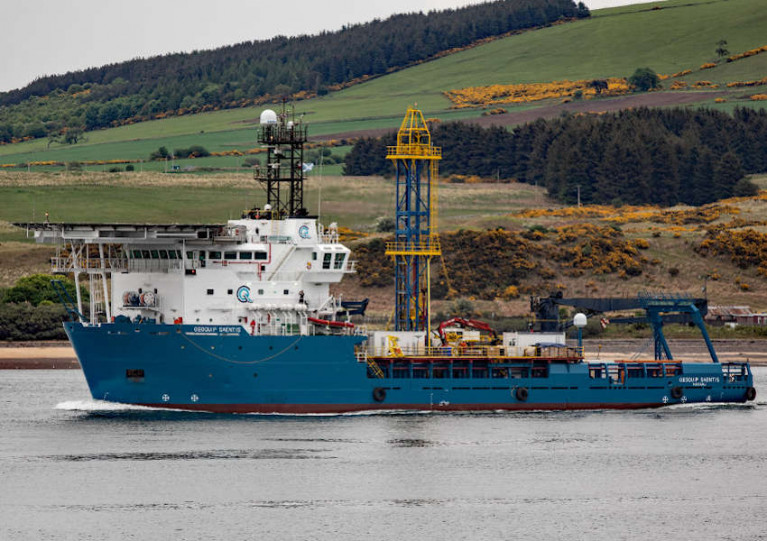
Survey works will be conducted by contractor Geoquip Marine using the Geoquip Saentis (Callsign C6UM8), an 80m dynamically positioned specialist survey vessel.
The Geoquip Saentis will be restricted in its ability to manoeuvre during its 24/7 survey operations, and other vessels in the are are requested to leave a wide berth.
Deployment Of Wave Monitoring Devices Off Wicklow Coast
Metocean devices will be deployed in the Irish Sea off the Wicklow coast) in the coming days, weather permitting, to provide environmental data for the development of the Arklow Bank Wind Park.
Similar to last autumn’s deployment, four separate devices to monitor waves and currents will be deployed, which will include a seabed frame with the sensors mounted on it, an anchoring system, and a surface marker buoy.
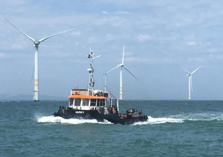
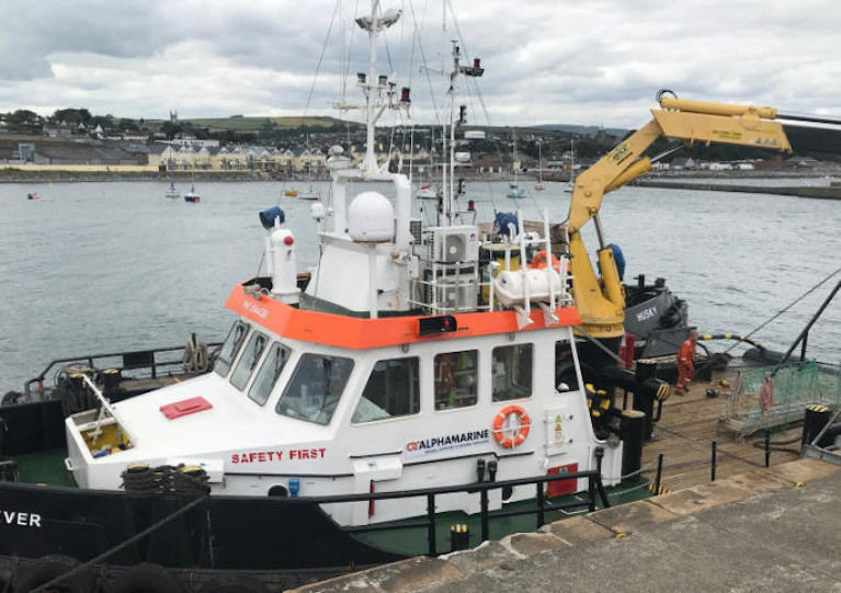
The devices will be deployed using either the AMS Retriever (Callsign MEHI8) or Husky (Callsign 2EQI7), both versatile multi-purpose shallow draft tugs. The devices will remain in place for approximately six months, serviced on a three-monthly basis.
During deployment and recovery operations, the AMS vessel will be restricted in its ability to manoeuvre. The devices will be located using yellow special mark buoys which will have the relevant markers and ATON characters.
The location of the devices will be off the Wicklow coastline as detailed in Marine Notice No 31 of 2020, which is available to download below.


 located at Ringsend on the south bank of Dublin Port. AFLOAT also add the Group over the last decade has invested over €30 million across MTL’s infrastructure and the terminal has a throughput of 250,000 TEU’s per year, with direct LoLo connections with ports in Central Europe and Irish Sea as well as feeder services connecting us with the Far East, India and South America.")

 linking Spain.")


 Michael Murphy Schull Harbour Sailing Club (SHSC), Eric Coogan Heineken Ireland, Mark Murphy, Commodore SHSC, Jack Allen SHSC, Carmel O'Regan SHSC, Cornelious Ndlovu, Schull Harbour Hotel Operations Manager and Derval Murphy SHSC")


