Menu

Ireland's sailing, boating & maritime magazine

Displaying items by tag: Mapping

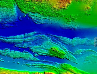
#MarineScience - Ciaran O’Donnell, a specialist in fisheries acoustic research with Fisheries Ecosystem Advisory services at the Marine Institute, has just begun a PhD research project that will link fisheries and seabed mapping acoustic technologies.

By using both technologies, he aims to learn more about how fish behave during acoustic surveys and therefore increase the precision of fish stock assessments.

O’Donnell’s research will focus on pelagic species – fish that swim in the water column – to see if there is avoidance behaviour during acoustic surveys and also to look at schooling behaviour and preferred habitat.

He’ll use the state-of-the-art multibeam echosounder system that has just been installed on the RV Celtic Explorer to look beyond the data normally captured during acoustic fisheries surveys to see if some or any of the fish being targeted by the survey are moving away from the research vessel as it passes overhead them.

“I’m really looking forward to the sea trials of the new multibeam next week (16-24 February) when we’ll get a chance to use the most advanced seabed mapping technology alongside acoustic fisheries technology. We should be able to see a much broader picture than before," said O'Donnell, a chief scientist on annual surveys for blue whiting, Celtic Sea herring and boarfish.

“Acoustic surveys are very targeted and focussed and this will allow us to capture new information about what the fish are doing beyond the target of the downward-looking fisheries echosounder. It will be like getting enhanced peripheral vision of the sea around the ship.

“We’ll be able to see if fish are moving away from the research vessel and out of the survey path and therefore will potentially enhance the precision of our current survey methods.”

The project will bring together technology and data from fisheries and seabed mapping and O’Donnell will work closely with the INFOMAR team and the advanced mapping services at the Marine Institute.

The research project, originally designed by the INFOMAR team, brings together a number of experienced researchers including Dr Chris McGonigle and Dr Rory Quinn of the University of Ulster, Dr Fabio Sacchetti of INFOMAR and the Marine Institute, and Dr David Reid of the Marine Institute and UCC.

Published in Marine Science
New developments in Ireland's capacity to uncover its past and explore its future economic potential will be revealed today and tomorrow (16th and 17th November) at a seminar on underwater mapping at the Marine Institute in Galway.

INFOMARNov2011AranSoundGalwayBay

Map of the Aran Sound in Galway Bay

Speakers at this annual seminar of the INFOMAR (INtegrated Mapping FOr the Sustainable development of Ireland's MARine Resource) programme will discuss the discovery of new and historic underwater wreck sites, the application of seabed mapping in the selection of sites for generating wave energy, the protection of fish spawning grounds, and the planning of fish farm sites.

The INFOMAR programme is a jointly managed programme between the Marine Institute and the Geological Survey of Ireland (GSI) and is funded by the Department of Communications, Energy and Natural Resources (DCNER).
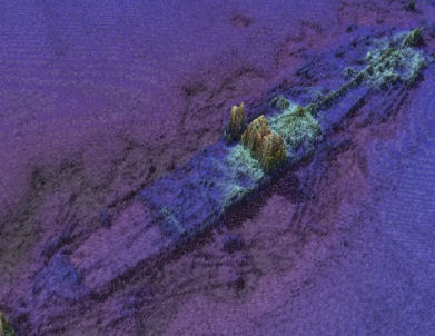
INFOMARNov2011ManchesterMerchant

Wreck of the SS. Manchester Merchant

The event will also feature the latest results from a range of EC funded marine mapping initiatives and stunning underwater footage from the recent Irish mission to the volcanic vents of the Mid-Atlantic Ridge over 3,000 metres below the surface of the sea.

Opening the seminar Dr. Peter Heffernan, CEO of the Marine Institute said, "Ireland is leading the way for Europe in marine mapping and in laying the foundations for the sustainable management of our ocean space. Surveying the gateways to our ports, mapping our fish spawning grounds, finding routes for marine telecommunications cables and selecting the best sites for ocean energy generation all rely on accurate seabed mapping capability, which Ireland now possesses."

In addition to its large scale marine mapping remit, INFOMAR's Value Added Programme is co-ordinating an integrated multidisciplinary approach to the handling, processing and application of its ever-expanding marine data set.
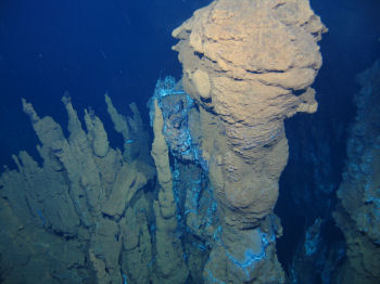
Ventpic2large

Deepwater photograph from the mid-Atlantic Ridge

As a result of its latest call for research proposals, INFOMAR received 32 submissions for studies on such subjects as the appraisal of seabed data for tidal energy generation, the integration of satellite and marine data for coastal mapping and the use of new graphic animation techniques to integrate environmental information into seabed mapping displays.

"INFOMAR is a key mechanism to unlock the economic potential of our ocean territory," said Koen Verbruggen of the GSI. "By linking industry and academia to the realisation of our government's objectives and requirements around sustainable ocean development we will strengthen Ireland's position on this new frontier and expand our capability to deliver services and solutions to all marine sectors – in Ireland, in Europe and across the world."
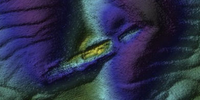
INFOMARNov2011WMBarkley

Wreck of the sunken Guinness ship W.M. Barkley off Dublin Bay

As well as looking to the future, Ireland's maritime past will be explored in a presentation by the Underwater Archaeology Unit of the Department of Arts, Heritage and the Gaeltacht on the discovery of a probably late 16th century wreck off Rutland Island, Co. Donegal. The wreck, which may have been an armed merchant ship, a pirate or naval vessel potentially associated with the local Gaelic lordships or the Spanish Armada of 1588, is an extremely important find that could add greatly to our understanding of Ireland's maritime heritage.

Published in Marine Science
Tagged under
Search and rescue mapping software developed in Rhode Island was "instrumental" in efforts to retrieve crewmembers from the stricken Rambler 100 off Fastnet last week.
The SARMAP software, developed by ASA (Applied Science Associates, Inc) provides rapid predictions of the movement of drifting objects and missing persons at sea.
For search and rescue units it can provide search patterns and calculate the probability of containment, probability of detection, and probability of success.
As previously reported on Afloat.ie, the Rambler 100 capsized off the Cork coast while competing in last weekend's Rolex Fastnet Race.
The Rambler 100’s personal locator beacon activated when the yacht overturned, which alerted rescuers to the location of the 16 stranded crewmembers still with the vessel, but recovering the five lost at sea required a more advanced approach.
The Irish Coast Guard employed SARMAP’s sophisticated tracking capabilities to predict the movement of the drifting survivors and calculate a precise search area.
ASA President Eoin Howlett commented: “We have successfully worked with the Irish Coast Guard for many years; they are an innovative agency and have a history of implementing the latest in ocean technologies.
"We are very pleased that our software, combined with their rapid decision-making, resulted in such a positive outcome.”

Search and rescue mapping software developed in Rhode Island was "instrumental" in efforts to retrieve crewmembers from the stricken Rambler 100 off Fastnet last week.

The SARMAP software, developed by ASA (Applied Science Associates, Inc) provides rapid predictions of the movement of drifting objects and missing persons at sea. 

For search and rescue units it can provide search patterns and calculate the probability of containment, probability of detection, and probability of success.

As previously reported on Afloat.ie, the Rambler 100 capsized off the Cork coast while competing in last weekend's Rolex Fastnet Race.

The Rambler 100’s personal locator beacon activated when the yacht overturned, which alerted rescuers to the location of the 16 stranded crewmembers still with the vessel, but recovering the five lost at sea required a more advanced approach.

The Irish Coast Guard used SARMAP’s sophisticated tracking capabilities to predict the movement of the drifting survivors and calculate a precise search area.


ASA president Eoin Howlett commented: “We have successfully worked with the Irish Coast Guard for many years; they are an innovative agency and have a history of implementing the latest in ocean technologies. 

"We are very pleased that our software, combined with their rapid decision-making, resulted in such a positive outcome.”

Published in Fastnet

Irish Fishing industry 

The Irish Commercial Fishing Industry employs around 11,000 people in fishing, processing and ancillary services such as sales and marketing. The industry is worth about €1.22 billion annually to the Irish economy. Irish fisheries products are exported all over the world as far as Africa, Japan and China.

FAQs

Over 16,000 people are employed directly or indirectly around the coast, working on over 2,000 registered fishing vessels, in over 160 seafood processing businesses and in 278 aquaculture production units, according to the State's sea fisheries development body Bord Iascaigh Mhara (BIM).

All activities that are concerned with growing, catching, processing or transporting fish are part of the commercial fishing industry, the development of which is overseen by BIM. Recreational fishing, as in angling at sea or inland, is the responsibility of Inland Fisheries Ireland.

The Irish fishing industry is valued at 1.22 billion euro in gross domestic product (GDP), according to 2019 figures issued by BIM. Only 179 of Ireland's 2,000 vessels are over 18 metres in length. Where does Irish commercially caught fish come from? Irish fish and shellfish is caught or cultivated within the 200-mile exclusive economic zone (EEZ), but Irish fishing grounds are part of the common EU "blue" pond. Commercial fishing is regulated under the terms of the EU Common Fisheries Policy (CFP), initiated in 1983 and with ten-yearly reviews.

The total value of seafood landed into Irish ports was 424 million euro in 2019, according to BIM. High value landings identified in 2019 were haddock, hake, monkfish and megrim. Irish vessels also land into foreign ports, while non-Irish vessels land into Irish ports, principally Castletownbere, Co Cork, and Killybegs, Co Donegal.

There are a number of different methods for catching fish, with technological advances meaning skippers have detailed real time information at their disposal. Fisheries are classified as inshore, midwater, pelagic or deep water. Inshore targets species close to shore and in depths of up to 200 metres, and may include trawling and gillnetting and long-lining. Trawling is regarded as "active", while "passive" or less environmentally harmful fishing methods include use of gill nets, long lines, traps and pots. Pelagic fisheries focus on species which swim close to the surface and up to depths of 200 metres, including migratory mackerel, and tuna, and methods for catching include pair trawling, purse seining, trolling and longlining. Midwater fisheries target species at depths of around 200 metres, using trawling, longlining and jigging. Deepwater fisheries mainly use trawling for species which are found at depths of over 600 metres.

There are several segments for different catching methods in the registered Irish fleet – the largest segment being polyvalent or multi-purpose vessels using several types of gear which may be active and passive. The polyvalent segment ranges from small inshore vessels engaged in netting and potting to medium and larger vessels targeting whitefish, pelagic (herring, mackerel, horse mackerel and blue whiting) species and bivalve molluscs. The refrigerated seawater (RSW) pelagic segment is engaged mainly in fishing for herring, mackerel, horse mackerel and blue whiting only. The beam trawling segment focuses on flatfish such as sole and plaice. The aquaculture segment is exclusively for managing, developing and servicing fish farming areas and can collect spat from wild mussel stocks.

The top 20 species landed by value in 2019 were mackerel (78 million euro); Dublin Bay prawn (59 million euro); horse mackerel (17 million euro); monkfish (17 million euro); brown crab (16 million euro); hake (11 million euro); blue whiting (10 million euro); megrim (10 million euro); haddock (9 million euro); tuna (7 million euro); scallop (6 million euro); whelk (5 million euro); whiting (4 million euro); sprat (3 million euro); herring (3 million euro); lobster (2 million euro); turbot (2 million euro); cod (2 million euro); boarfish (2 million euro).

Ireland has approximately 220 million acres of marine territory, rich in marine biodiversity. A marine biodiversity scheme under Ireland's operational programme, which is co-funded by the European Maritime and Fisheries Fund and the Government, aims to reduce the impact of fisheries and aquaculture on the marine environment, including avoidance and reduction of unwanted catch.

EU fisheries ministers hold an annual pre-Christmas council in Brussels to decide on total allowable catches and quotas for the following year. This is based on advice from scientific bodies such as the International Council for the Exploration of the Sea. In Ireland's case, the State's Marine Institute publishes an annual "stock book" which provides the most up to date stock status and scientific advice on over 60 fish stocks exploited by the Irish fleet. Total allowable catches are supplemented by various technical measures to control effort, such as the size of net mesh for various species.

The west Cork harbour of Castletownbere is Ireland's biggest whitefish port. Killybegs, Co Donegal is the most important port for pelagic (herring, mackerel, blue whiting) landings. Fish are also landed into Dingle, Co Kerry, Rossaveal, Co Galway, Howth, Co Dublin and Dunmore East, Co Waterford, Union Hall, Co Cork, Greencastle, Co Donegal, and Clogherhead, Co Louth. The busiest Northern Irish ports are Portavogie, Ardglass and Kilkeel, Co Down.

Yes, EU quotas are allocated to other fleets within the Irish EEZ, and Ireland has long been a transhipment point for fish caught by the Spanish whitefish fleet in particular. Dingle, Co Kerry has seen an increase in foreign landings, as has Castletownbere. The west Cork port recorded foreign landings of 36 million euro or 48 per cent in 2019, and has long been nicknamed the "peseta" port, due to the presence of Spanish-owned transhipment plant, Eiranova, on Dinish island.

Most fish and shellfish caught or cultivated in Irish waters is for the export market, and this was hit hard from the early stages of this year's Covid-19 pandemic. The EU, Asia and Britain are the main export markets, while the middle Eastern market is also developing and the African market has seen a fall in value and volume, according to figures for 2019 issued by BIM.

Fish was once a penitential food, eaten for religious reasons every Friday. BIM has worked hard over several decades to develop its appeal. Ireland is not like Spain – our land is too good to transform us into a nation of fish eaters, but the obvious health benefits are seeing a growth in demand. Seafood retail sales rose by one per cent in 2019 to 300 million euro. Salmon and cod remain the most popular species, while BIM reports an increase in sales of haddock, trout and the pangasius or freshwater catfish which is cultivated primarily in Vietnam and Cambodia and imported by supermarkets here.

The EU's Common Fisheries Policy (CFP), initiated in 1983, pooled marine resources – with Ireland having some of the richest grounds and one of the largest sea areas at the time, but only receiving four per cent of allocated catch by a quota system. A system known as the "Hague Preferences" did recognise the need to safeguard the particular needs of regions where local populations are especially dependent on fisheries and related activities. The State's Sea Fisheries Protection Authority, based in Clonakilty, Co Cork, works with the Naval Service on administering the EU CFP. The Department of Agriculture, Food and Marine and Department of Transport regulate licensing and training requirements, while the Marine Survey Office is responsible for the implementation of all national and international legislation in relation to safety of shipping and the prevention of pollution.

Yes, a range of certificates of competency are required for skippers and crew. Training is the remit of BIM, which runs two national fisheries colleges at Greencastle, Co Donegal and Castletownbere, Co Cork. There have been calls for the colleges to be incorporated into the third-level structure of education, with qualifications recognised as such.

Safety is always an issue, in spite of technological improvements, as fishing is a hazardous occupation and climate change is having its impact on the severity of storms at sea. Fishing skippers and crews are required to hold a number of certificates of competency, including safety and navigation, and wearing of personal flotation devices is a legal requirement. Accidents come under the remit of the Marine Casualty Investigation Board, and the Health and Safety Authority. The MCIB does not find fault or blame, but will make recommendations to the Minister for Transport to avoid a recurrence of incidents.

Fish are part of a marine ecosystem and an integral part of the marine food web. Changing climate is having a negative impact on the health of the oceans, and there have been more frequent reports of warmer water species being caught further and further north in Irish waters.

Brexit, Covid 19, EU policies and safety – Britain is a key market for Irish seafood, and 38 per cent of the Irish catch is taken from the waters around its coast. Ireland's top two species – mackerel and prawns - are 60 per cent and 40 per cent, respectively, dependent on British waters. Also, there are serious fears within the Irish industry about the impact of EU vessels, should they be expelled from British waters, opting to focus even more efforts on Ireland's rich marine resource. Covid-19 has forced closure of international seafood markets, with high value fish sold to restaurants taking a large hit. A temporary tie-up support scheme for whitefish vessels introduced for the summer of 2020 was condemned by industry organisations as "designed to fail".

Sources: Bord Iascaigh Mhara, Marine Institute, Department of Agriculture, Food and Marine, Department of Transport © Afloat 2020