


Displaying items by tag: research
Galway Meeting Highlights Importance Of Ocean Observation In Europe
#MarineScience - More than 70 leading marine scientists from across Europe met in Galway recently to discuss open access to research on ocean observation.
The Marine Institute in Oranmore hosted the second general assembly of the EU-funded Jerico-NEXT Project, which aims to build on the ongoing co-operation of coastal observatories in Europe — such as SmartBay in Galway — for wider application by the research community and society alike.
A fundamental tenet of the project is that coastal areas are the “most productive and dynamic environment” in the world’s oceans, according to the institute, with significant potential for renewable energy in particular.
“The Marine Institute has a longstanding commitment to the collection, processing and analysis of high quality coastal marine observations,” said the institute’s Paul Gaughan.
“In Ireland we are utilising the SmartBay coastal observatory, located 5km off Spiddal in Galway Bay, as a key component in this trans-European collaboration effort.
“From this we are able to deliver high quality information about sea conditions, subsea video and audio data in real-time to scientists around Europe to access and analyse.”
Data from the SmartBay site are freely available online.
The Marine Institute also recently hosted a delegation of officials from Kenya as part of the Memorandum of Understanding signed last year with the Kenyan Marine Fisheries Research Institute (KMFRI).
The official visit focused on developing an action plan around seven priority areas outlined in the MoU, which include plans for marine fisheries management, hydro-acoustics and assessment of pelagic fisheries resources.
Other priorities are spatial analysis and mapping of vessel monitoring system (VMS) data, integration of VMS and logbook data for fisheries management, and a data management strategy.
Opportunities for exchange, study visits and developing joint PhD and post-doctoral research projects were also a focus of discussions.
Shiptime Charter Applications For 2019 & 2020 Now Open

#MarineScience - Applications are open for shiptime in 2019 and 2020 on Ireland’s national research vessels Celtic Explorer and Celtic Voyager, as well as the ROV Holland I and the Laochra na Mara glider.
Every year a broad range of organisations use the Marine Institute’s vessels for research, development and monitoring programmes. These include Government departments and agencies, universities, research institutes and industry.
Applications for shiptime for 2019 and 2020 must be submitted using Research Vessel Operations’ online Survey Planning System (SPS) by Thursday 20 September. Please contact Research Vessel Operations to obtain an SPS login if you don’t already have one and to inquire about glider availability.
Each application will be reviewed and the applicant will be informed as soon as possible whether the shiptime they requested is available. If the requested shiptime is not available, alternative dates may be offered. The Vessel Charter Guidelines should be read carefully before submitting the ship time application form.
Applicants may seek grant aid to cover all or part of the vessel charter costs for research surveys or ship-based Training Programmes. The closing date for receipt of grant aid applications is 5pm on Friday 21 September.
Applicants for ship-based training are advised to consult with the Strategic Marine Alliance for Research and Training (SMART) at [email protected].
The survey schedules can change during the year, therefore please contact Research Vessel Operations to check whether any survey slots remain for 2018 or to be notified if any dates become available.
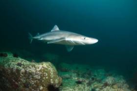
Irish Deep Water Coral Reefs Changing Faster Than Previously Thought, Says New Research
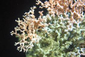
#MarineScience - One of Ireland’s deep water coral reefs is changing at a rate of some 20% over four years, faster than previously thought.
That’s according to new research published by Dr Aaron Lim of the Marine Geology Research Group at University College Cork.
Images and samples were retrieved from the cold water reefs on two separate occasions using the Marine Institute’s ROV Holland 1 operated from the RV Celtic Explorer — representing “the first ever successful attempt at imaging an entire deep water reef” at 1km below the surface, explains Dr Lim.
“Over half the species of coral in the world are cold, deep-water species and many of them can be found in Irish waters between water depths of 600m and 1,000m,” he added.
One of the most prolific places on the planet for deepwater coral development is the Belgic Mound Province, at the Porcupine Bank on the Irish continental margin, where there are over fifty giant coral mounds and 300 smaller coral reefs.
In 2011 and 2015, the Holland 1 was used by marine scientists to capture images and footage of the entire surface of one of these reefs, “which has for the first time has provided us the insight into how the reefs grow at this scale,” Dr Lim said.
“Initial results showed that the reef was extremely variable and is coping with the contemporary environmental conditions,” said Prof Andy Wheeler, head of geology at UCC and who has been working in Ireland’s corals for 20 years.
“However, the issue is that it is so difficult to take images of the deep ocean that we can only get bits of information from these reefs during an expedition.”
Dr Lim added: “The importance of this technology and having access to the national research vessel has meant that we can get access to what was only a few decades ago inaccessible. We can now provide a detailed analyses of the reef, showing that it changed at a rate of 20% in four years.”
Unlike its tropical water counterparts, which suffer from mass coral bleaching events, the proportion of live coral on this reef did not change.
“The change was in fact an increase in the proportion of dead coral and coral rubble areas, which is not the result of live coral dying, but possibly due to the result of strong currents exposing dead coral buried beneath older parts of the reef,” Dr Lim said.
“Assuming the change continues at this rate, then in 20 years the reef will entirely change.”
Dr Lim and Prof Wheeler have commenced a sizeable research project to monitor a range of coral habitats on the Irish margin with the aim of understanding what is driving these habitats and what makes them change. This research has been funded by the Irish Research Council, the Marine Institute and UCC.
Celtic Voyager Explores Irish Sea’s Lost landscapes
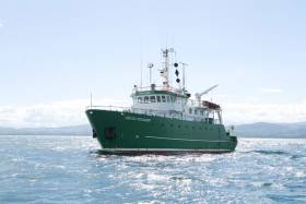
#MarineScience - An Irish research team from IT Sligo and University College Cork recently joined the ‘Europe’s Lost Frontiers’ project to explore the extensive submerged landscapes in the Irish Sea aboard the Marine Institute’s Celtic Voyager research vessel research vessel.
Following the last Ice Age, large areas of habitable land were inundated following climate change and sea level rise across the world. Globally, the sea level rose around 120 metres and an area more than twice that of the modern United States of America was lost to the sea.
Beneath the waves of the Irish Sea is a prehistoric ‘palaeolandscape’ of plains, hills, marshlands and river valleys in which evidence of human activity is expected to be preserved.
This landscape is similar to Doggerland, an area of the southern North Sea and currently the best known example of a palaeolandscape in Europe. Doggerland has been extensively researched by Prof Vince Gaffney, principal investigator of the Europe’s Lost Frontiers project.
“Research by the project team has also provided accurate maps for the submerged lands that lie between Ireland and Britain,” said Prof Gaffney, “and these are suspected to hold crucial information regarding the first settlers of Ireland and adjacent lands along the Atlantic corridor.”
To provide this evidence, sediment from some 60 cores, taken from 20 sites by the RV Celtic Voyager in Liverpool and Cardigan Bays between the 21 and 25 February, will be studied by an international marine research team.
Dr James Bonsall, from the Centre for Environmental Research Innovation and Sustainability (CERIS) in the Department of Environmental Science at IT Sligo, was chief scientist for this phase of the research, and together with his CERIS colleague, environmental scientist Eithne Davis, directed operations on board the RV Celtic Voyager.
“It is very exciting,” said Dr Bonsall, “as we’re using cutting-edge technology to retrieve the first evidence for life within landscapes that were inundated by rising sea levels thousands of years ago.
“This is the first time that this range of techniques has been employed on submerged landscapes under the Irish Sea. Today we perceive the Irish Sea as a large body of water, a sea that separates us from Britain and mainland Europe, a sea that gives us an identity as a proud island nation. But 18,000 years ago, Ireland, Britain and Europe were part of a single landmass that gradually flooded over thousands of years, forming the islands that we know today.
“We’re going to find out where, when, why and how people lived on a landscape that today is located beneath the waves.”
Key outcomes of the research will be to reconstruct and simulate the palaeo-environments of the Irish Sea, using ancient DNA, analysed in the laboratories at the University of Warwick, and palaeo-environmental data extracted from the sediment cores.
The studies will be of immense value in understanding ‘first’ or ‘early’ contact and settlement around the coasts of Ireland and Britain, but also the lifestyles of those people who lived within the inundated, prehistoric landscapes that lie between our islands and which have never been adequately explored by archaeologists.
The Celtic Voyager and the Marine Institute’s expertise were provided to explore the extensive submerged landscapes, where marine core samples were taken. Technical support setting up the seabed survey and navigation systems was also provided by members of the DCCAE-funded INFOMAR team, who specialise in bathymetric mapping and geophysical survey.
This research survey was carried out with the support of the Marine Institute, funded under the Marine Research Programme 2014-2020 by the Irish Government.
Europe’s Lost Frontiers is an ERC-funded Advanced Grant project based at the University of Bradford. Aimed at understanding the transition between hunter gathering to farming in north-west Europe, the project is studying the evidence for inundated palaeolandscapes around the British coast using seismic reflectance data sets to generate topographical maps of these ‘lost lands’ that are as accurate and complete as possible.
Environmental data from these areas is then being used to reconstruct and simulate the palaeo-environments of these landscapes using ancient DNA extracted directly from sediment cores as well as traditional environmental evidence.
Council Seeks More Details On Connemara ‘Marine Innovation Park’ Proposals
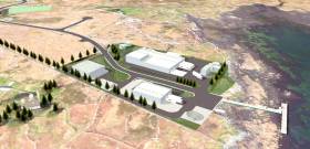
#PáircNaMara - Galway County Council is seeking further details on the Páirc na Mara development for Connemara, following an objection from a local group opposed to salmon farming.
New plans for the ‘marine innovation park’ were submitted late last year by Údáras na Gaeltachta, envisaging a low-carbon marine industry hub over nine hectares, and with a focus on aquaculture research.
But as Galway Bay FM reports, an objection by Galway Bay Against Salmon Cages — which has long campaigned against aquaculture projects in the region — has “caused anger in west Connemara” where the park is slated to be developed.
The situation has now prompted the council to seek more information on the fish farming aspects of the project.
Galway Bay FM has more on the story HERE.
IWDG Requires Bottlenose Dolphin Research Assistants For The Shannon Estuary
#MarineScience - The Irish Whale and Dolphin Group’s Shannon Dolphin Project is seeking research assistants from May-September 2018 based in Kilrush, Co Clare.
Research assistants will be required to conduct monitoring surveys from dolphin-watching tour boats, spend a considerable amount of time on Shannon Estuary bottlenose dolphin photo identification and related office tasks, and assist in the management of the dolphin centre on a daily basis.
Photo ID training will be provided on the boats and in the office. There will also be the opportunity to help with research conducted on board the IWDG’s research vessels Muc Mhara and Celtic Mist, and to assist the IWDG with cetacean strandings should the opportunity arise.
These positions provide an excellent opportunity to develop skills in marine research and education and to assist with one of the longest-running bottlenose dolphin population monitoring programs in Europe.
There is no monetary compensation for these positions and a contribution of €400 per month towards accommodation and utilities is required.
Volunteers will be expected to work and live as part of a team with shared cooking and cleaning duties. Accommodation will be provided in a shared house within walking distance of the dolphin centre and town of Kilrush. Research assistants are responsible for their own food costs and travel expenses to and from Kilrush.
The closing date for applications is Friday 30 March. However, early application is recommended. Shortlisted candidates will be required to undertake a Skype interview in April. Successful applicants will be notified by mid-April.
Full details on the positions can be found on the IWDG website HERE.
MaREI Centre Recruiting Senior Post-Doc Researcher
#MarineScience - Applications are invited for the post of Senior Post-Doctoral Researcher to join the MaREI Centre for Marine and Renewable Energy in University College Cork (UCC), based at the Beaufort Building in Ringaskiddy.
MaREI is a key research centre within UCC’s Environmental Research Institute (ERI) which is an internationally recognised Institute for environmental research dedicated to the understanding and protection of our natural environment and to developing innovative technologies, tools and services to facilitate a transformation to a zero-carbon and resource-efficient society.
Researchers in the MaREI Centre have over 30 years of experience in conducting fundamental and applied research supported by competitively won national and international funding, and commercial contracts with government agencies and industry.
MaREI’s strengths lie in the multi-disciplinary nature of its research teams, allowing it to combine insights across areas such as MRE Technologies, Materials & Structures, Observation & Operations, Coastal & Marine Systems, Bioenergy, Energy Policy & Modelling, and Renewable Energy Management.
The candidate will lead research focussed on but not limited to Horizon 2020 project the Coastal Waters Research Synergy Framework, or Co-ReSyf, which is currently developing a dedicated data access and online processing platform, with automated tools, methods and standards to support research application and data synergies using Earth observation (EO) data for the monitoring of coastal waters.
The main objective is better enable the research community to access a variety of dedicated data and pre-processing tools and, thus facilitate the provision of EO based, coastal waters services.
The Co-ReSyf platform is developed based on extensive user requirement gathering and stakeholder engagement, to which the candidate will contribute, as required.
UCC is a member of the Co-ReSyf consortium, and the project is one of a number of initiatives currently underway within the MaREI EO group. As a result, the successful candidate is expected to contribute to a number of current projects.
The deadline for applications is this Friday 16 February. More details are available from the UCC website HERE.
Budding Coastal Researchers, Don’t Miss This PhD Funding Call
#MarineScience - This Friday 16 February is the deadline for applications to the Hardiman PhD Scholarships — and if beaches and coastal research are your passion, NUI Galway lecturer Eugene Farrell wants you to get in touch.
High achievers with an appetite for research and creativity are urged to submit their interest in the funding call which can provide a stipend of €16,000 per annum plus fees for four years.
Details on eligibility and how to apply are available from the NUI Galway website HERE.
Connemara Sea Scouts Solve Mystery Of Marine Research Buoy
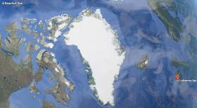
#ArcticBuoy - A marine research buoy found on the Connemara coast by local Sea Scouts recently had drifted over 6,000 kilometres across the Beaufort Sea, Arctic Ocean and Atlantic to Ireland.
The buoy, around half a metre in diameter, was found at Lettermullen by the scout troop during an exploration of their local beach.
Michael Loftus, leader of Gasógaí Mara na Gaeltachta (Connemara Sea Scouts), said they often find flotsam and jetsam washed up on the shore, which they can usually identify.
“However, little did we know that this new find would uncover a world of discovery relating to the buoy being launched from an aircraft in the Arctic Ocean and travelling thousands of kilometres to land on the west coast of Ireland.”
The Marine Institute, which works on a series of projects where autonomous instruments are deployed into the ocean for marine research, was contacted to help solve the mystery of where the red buoy came from.
“Although the buoy is not an Argo float that is typically used by the institute as part of the national Argo float programme, we were delighted to help the Sea Scouts establish that the buoy is in fact an Airborne Expendable Ice Buoy, which came from as far away as the Beaufort Sea,” said Diarmuid Ó Conchubhair of the Marine Institute.
The International Arctic Buoy Programme involves a number of different countries including Canada, China, France, Germany, Japan, Norway, Russia, and the United States.
The programme maintains a network of drifting buoys in the Arctic Ocean that are used to monitor sea surface temperatures, ice concentration, and sea level and support weather forecasting. The buoys are also used for validating climate or earth system models which inform the Intergovernmental Panel on Climate Change (IPCC) reports.
Each buoy in this programme has an identification number that is used to track its location in the Arctic Ocean using a type of satellite communication system.
“Using the number marked on this buoy [#4800512], we were able to establish that this particular buoy had been deployed by an aircraft over five years ago in the Beaufort Sea, north of the Yukon and Alaska, west of Canadian Arctic islands,” said Ó Conchubhair.
Dr Eleanor O’Rourke, oceanographic services manager at the Marine Institute, explained: “Researchers involved in the International Arctic Buoy Programme decide where to deploy buoys, particularly where the status of sea-ice may be changing.
“Most of the buoys are placed on sea ice, but some are placed in open water in some of the most remote parts of the world's ocean, where it is difficult for research vessels to access.”
Airborne Expendable Ice Buoys have an average lifespan of 18 months and around 25 to 40 buoys operate at any given time.
“The buoy last reported its data in 2014 and it is likely that it ran out of battery power and spent the last three to four years at the sea surface travelling via wind and ocean surface currents,” said O’Rourke.
In 2007, Ireland became a member of the international Argo programme, which uses robotic instruments known as autonomous Argo floats that report on subsurface ocean water properties such as temperature and salinity via satellite transmission to data centres.
Using a fleet of around 4,000 autonomous floats around the world, the Argo array is an indispensable component of the Global Ocean Observing System (GOOS).
“Similar to the buoys used by the International Arctic Buoy Programme, Argo floats collect and distribute real time information on the temperature and salinity of the ocean,” said Ó Conchubhair, who is vice chair of the European Argo Programme.
“Argo floats; however, measure these variables from the upper 2,000m of the ocean and help to describe long-term trends in ocean parameters such as their physical and thermodynamic state.”
This information is required to understand and monitor the role of the ocean in the Earth's climate system, in particular the heat and water balance.
Click here for more information about Ireland’s involvement in the Argo programme. You can also track and look at data from Irish Argo floats at Ireland’s Digital Ocean.
Four years ago, another Arctic device was found on the North West Coast and exhibited by Transition Year students in Co Mayo, as previously reported on Afloat.ie.
Closing Dates Approaching For Temporary Research & Admin Roles With Marine Institute
#Jobs - The closing dates for applications are approaching for number of temporary research and administrative vacancies with the Marine Institute.
A self-motivated, enthusiastic and experienced Administrative Assistant (Executive Officer) is being sought to ensure high quality, timely and accurate reporting for Oceanographic Services (OS) EU-funded projects over a three-year period. Applications close at noon tomorrow, Thursday 4 January.
Next Monday 8 January is the closing date for two roles with the PRIMROSE (Predicting risk and impact of harmful algal bloom events that cause impact to the shellfish aquaculture sector) project.
A Post-Doctoral Data Analyst is sight to develop a string scientific partnership between the members of the INTERREG Atlantic Area Funded project consortium across Europe. The successful candidate will also be expected to develop and deliver scientific presentations at international conferences during the project.
The post-doc research assistant will also be aided by a Temporary Scientific & Technical Officer Project Coordinator, who will track and report the progress of the project’s work as well as develop a high level of knowledge in the technical areas of Harmful Algal Bloom science and forecasting.
Applications will be accepted till noon on Thursday 11 January for the role of Temporary Administrative Assistant (Executive Officer) with the Office of Research and Development.
The successful applicant will have with primary responsibility for supporting financial and administrative reporting for Marine Institute participation in the EU INTERREG projects, Compass (for a monitoring buoy network between Britain and Ireland) and Bluefish (to develop knowledge and understanding of the marine resources of the Irish Sea and Celtic Seas and the related impact of climate change).


 located at Ringsend on the south bank of Dublin Port. AFLOAT also add the Group over the last decade has invested over €30 million across MTL’s infrastructure and the terminal has a throughput of 250,000 TEU’s per year, with direct LoLo connections with ports in Central Europe and Irish Sea as well as feeder services connecting us with the Far East, India and South America.")

 linking Spain.")


 Michael Murphy Schull Harbour Sailing Club (SHSC), Eric Coogan Heineken Ireland, Mark Murphy, Commodore SHSC, Jack Allen SHSC, Carmel O'Regan SHSC, Cornelious Ndlovu, Schull Harbour Hotel Operations Manager and Derval Murphy SHSC")


