


Displaying items by tag: AIS
Belfast Harbour Hosts Innovative Study With Objective to Become A Smart & Green Port
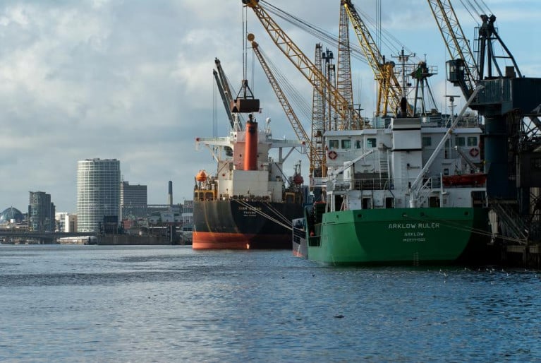
In what is been described as a ground-breaking project, Belfast Harbour has already embarked upon a strategy to digitise, decarbonise and decentralise its energy usage throughout the port's 3,000-acre harbour estate.
The new initiative will further help enhance the port's commitment to uphold the highest environmental standards through innovative technology.
In a joint collaboration between Leicestershire-based Redshift Associates and the University of Leicester, the project will develop analytic solutions to extract operational information on shipping from remote sensing data by using the marine Automatic Identification System (AIS). This will enable the company to determine pollution emissions in real-time from shipping underway or in harbour.
Founder and director of Red Associaites, Professor Alan Wells said: “Redshift Associates is bringing together new approaches to air pollution in ports and harbours through satellite remote sensing. The project will be funded by a grant from the £4.8m SPRINT (SPace Research and Innovation Network for Technology) business support programme.
Mr Wells added: “The basis of our collaboration with the University of Leicester, through the SPRINT programme, is its support in taking the visual data and applying a high level of validation and interpretation.”
In a feasibility study for the new service, the project team is working in partnership with Belfast Harbour to evaluate pollution emissions from shipping and other industrial activity to assess the overall atmospheric emissions inventory within the harbour estate. Redshift Associates will identify measures that will support an air quality action plan in line with the port’s sustainability vision.
The project is expected to contribute to the development of a space-enabled, commercial monitoring service for ports and harbours for maximising energy saving, pollution reduction, decarbonisation and transition to renewable energy options for port operations.
Clipper Race Developing New Automatic AIS Beacon
#clipper – One year after an MOB in the middle of the Pacific Ocean, during the Clipper 2013-14 Round the World Yacht Race, in which a crew member was successfully rescued after 100 minutes in the water, organisers have revealed the development of a new automatically activated AIS beacon.
"It was a result of the crew member's experience, the fact that he could have been knocked unconscious when he hit the rudder, the fact that his lifejacket did not automatically inflate (we found the reason for this later) and that his beacon was initially switched onto test instead of activate, causing a life threatening delay, we decided to try to create an automatically activated beacon," explained Clipper Race founder and chairman Sir Robin Knox-Johnston.
"After close collaboration and intense development between the Clipper Race team, technology partner Spinnaker International and McMurdo Group, I am glad to say that we now have a prototype, using the McMurdo AIS Beacon and will be making sea trials in mid-April. We were lucky to get Andrew back and at the Clipper Race we don't believe in relying on luck where safety is concerned."
Andrew Taylor, 47, was hit by a huge wave and swept overboard on 30 March 2014 from the Derry~Londonderry~Doire entry. His incredible man overboard rescue is told in a book launched today called '179W – One Seven Nine West' named after the exact co-ordinates where he fell overboard; it details his fight for survival and pays tribute to the training, team and equipment that saved his life.
Andrew commented: "Many of the fleeting moments on that fateful day could easily have ended differently. As could have the subsequent story's ending. I genuinely believe, as a result of some of the outcomes of this incident, that lives will now be saved in the future and for both this, and escaping with my own life, I am totally humbled and shall be eternally grateful to very many special people."
When Andrew activated his McMurdo AIS MOB device after about an hour in the water, his crew was able to pinpoint his exact location and come to his aid faster than following their search pattern; vital minutes for Andrew's survival after being in the water for so long.
"We are delighted to be celebrating Andrew's amazing story here today," said Jean-Yves Courtois, CEO of Orolia, McMurdo's parent corporation. "At McMurdo we strive to make it possible for people to do what they love, whether it's sailing, flying or exploring, and to keep them safe while they pursue their dreams. Andrew's story exemplifies this – his crew and our technology kept him safe to race another day."
Marine Notice: AIM Requirements For Seagoing Passenger Ships
#MarineNotice - As of 31 October 2014, there will be new requirements for Automatic Identification Systems (AIS) for passenger ships of classes B, C, D, IIA, III and VI.
The European Communities (Vessel Traffic Monitoring and Information System) Regulations 2010 [SI No 573 of 2010] as amended by the European Communities (Vessel Traffic Monitoring and Information System) (Amendment) Regulations 2012 [SI No 71 of 2012] include the requirements for approved AIS to be fitted on vessels.
Regulation 9A sets out the scope for exemptions from the requirements of Regulations 8 and 9, which may include passenger ships below 15 metres in length or 300 gross tonnage engaged on non-international voyages, and Marine Notice 22 of 2012 refers to such exemptions from the requirements to fit an approved AIS for domestic passenger vessels of less than 15m or 300GT.
Vessels less than 15 metres in length will in general be exempted from the requirement to fit an approved AIS (ie, one which satisfies the performance standards drawn up by the International Maritime Organisation) but will, in most cases, be required to fit AIS type B.
The specific exemption criteria and conditions thereof, together with the detailed carriage requirements for AIS on seagoing domestic passenger vessels are set out in the annex to Marine Notice No 51 of 2014, a PDF of which is available to read or download HERE.
The Marine Survey Office will verify compliance with the carriage requirements and the operation of the AIS during annual surveys and inspections of passenger vessels from 31 October.
Smartphone App Helps Boat Lost in Fog

#Smartphone - A yacht managed to avoid collision with a container ship off the coast of South Africa recently - thanks to a smartphone app.
As Yachting Monthly reports, Ian Engelbrecht and crew Ibolya Palko were delivering a catamaran from Cape Town to Durban when they were trapped in thick fog not far the coastline.
When their primary AIS system stopped working, Engelbrecht turned on a smartphone app called Boat Beacon as a way to alert them to any other ships in the vicinity.
The app did its job, alerting the pair to a container vessel travelling in the opposite direction, though they were unsure of what corrective action to take due to the poor visibility and not knowing the closest point of approach (CPA).
Despite this, collision was averted - and the incident has prompted the app developers to add a CPA bearing feature to their product.
Yachting Monthly has more on the story HERE.
Irish Coast Guard Collaborates On New Marine Monitoring System
#Coastguard - The Irish Coast Guard is collaborating on a new system of marine monitoring in the hopes of detecting a dead ship that may threaten to run aground on Ireland's shores.
The Newfoundland Shipping News blog details how the MV Lyubov Orlova, adrift somewhere in the North Atlantic, is being used to test the capabilities of a new system called Global Maritime Awareness.
The system is based on the idea that if the world's top satellite tracking technologies could be banded together, it could establish a much more comprehensive monitoring system for the marine environment.
Marine surveillance expert Guy Thomas, who devised the concept, said he had the idea that if a receiver akin to that used in the Automatic Identification System (AIS) for ship tracking and collision avoidance was put on a satellite in orbit, "you would now have the international identification system for ships that was lacking".
That was done, and a second accompanying system was added that provides radar information from space. The Global Maritime Awareness system combines those with detailed satellite imagery, and Long Range Identification and Tracking {LRIT) technology whereby ships can verify themselves to others and the systems tracking them.
Thomas says these four satellite systems working in tandem make for "a very effective tool in monitoring marine environments for illegal activity".
But it can also be used to prevent potential environmental catastrophes - which is where the MV Lyubov Orlova comes in.
The Irish Coast Guard's director Chris Reynolds contacted Thomas with its concerns that the dead ship might drift into Irish waters and become a burden on the State. Thomas suggested using his system to find it, almost like an ocean-wide version of the game Battleships: even when a ship isn't sending any signals, it can still be tracked, just by looking for ships that aren't transcending through AIS.
Thomas and the Irish Coast Guard are currently working hard at this, crossing off vessels that are communicating through satellite systems till they can narrow it down to the one they're looking for. And they may now have a hit south-southeast of Greenland, although it will be some days before they can confirm.
Newfoundland Shipping News has much more on the story HERE.
Coveney Welcomes Refloating of Ship at Rossaveal
Minister Coveney paid tribute to all those involved in what he described as "a very successful operation in very challenging conditions. Having visited Ros an Mhíl yesterday evening and spoken to those involved, including the Harbour Master and the Coast Guard, the scale of the challenge was evident, involving such a large vessel carrying a substantial fuel load. There was a very real threat to the marine environment and it is a testament to the professionalism of all those involved that such a threat was averted."
The Minister said that he was "glad to have had the opportunity to see at first hand the professionalism and competence of all the agencies involved, including the Harbour Master and his staff, the Irish Coast Guard, An Garda Siochana and Galway County Council." Minister Coveney also acknowledged the assistance and co-operation provided by the ship's representatives in reaching a successful conclusion to this incident.
Minister Coveney confirmed that "the incident would be thoroughly investigated by the Marine Casualty Investigation Board". The Minister said that "the vessel is now anchored off the north Clare coast where it is currently undergoing a detailed inspection. The vessel will continue to be monitored by the Irish Coast Guard on the AIS system (Automatic Identification System)."
Jack up Barge Arrives on Dublin Bay
These jack-up barges will be used for the drilling of test boreholes at various locations within Dublin Bay and its approaches. Initially, the "Aran 250" will be used and it is expected that under normal conditions it will operate on a 24 hour / 7 day week basis.
At all times when the jack-up barge is on location it will transmit an "AIS" signal. By night the barge will display white lights (operated in unison) flashing Morse code (U) every 15 seconds. These will be located at each corner. The barge itself will be lit by operational deck lights.
When the jack-up barge is operational it will have the standby boat "James Joyce" with two people on board in attendance. They will tie-up to a buoy moored approximately 300 metres away from the barge. The small tug "Trojan" will operate as a supply boat and will be based at the Poolbeg Marina. The Trojan will also be used for towing the barge from one location to the next.
The test borehole drilling positions (WGS 84) are as follows :-
M06 Lat 53˚ 19' 53.46'' N Long 006˚ 09' 39.08'' W M15 Lat 53˚ 19' 11.35'' N Long 006˚ 06' 58.16'' W
M07 Lat 53˚ 19' 11.27'' N Long 006˚ 08' 21.42'' W M16 Lat 53˚ 18' 32.75'' N Long 006˚ 06' 33.07'' W
M08 Lat 53˚ 19' 50.64'' N Long 006˚ 06' 21.73'' W M17 Lat 53˚ 20' 23.37'' N Long 006˚ 05' 16.93'' W
M09 Lat 53˚ 18' 38.17'' N Long 006˚ 05' 45.02'' W M18 Lat 53˚ 19' 32.50'' N Long 006˚ 05' 19.69'' W
M10 Lat 53˚ 17' 44.38'' N Long 006˚ 03' 41.33'' W M19 Lat 53˚ 18' 16.91'' N Long 006˚ 05' 02.71'' W
M11 Lat 53˚ 19' 42.31'' N Long 006˚ 03' 22.31'' W M20 Lat 53˚ 17' 51.94'' N Long 006˚ 04' 43.04'' W
M12 Lat 53˚ 19' 00.03'' N Long 006˚ 00' 25.74'' W M21 Lat 53˚ 18' 56.68'' N Long 006˚ 04' 07.12'' W
M13 Lat 53˚ 19' 51.50'' N Long 006˚ 10' 13.42'' W M22 Lat 53˚ 19' 09.75'' N Long 006˚ 02' 37.54'' W
M14 Lat 53˚ 19' 59.29'' N Long 006˚ 07' 53.39'' W M23 Lat 53˚ 18' 48.98'' N Long 005˚ 59' 07.97'' W
Each location will take approximately 1 week to drill. Drilling will not follow in sequence listed above. VTS will keep all shipping advised with regards to the location at which the barge is operating.
More detail is contained in a marine notice issued by Dublin Port Company's
Harbour Master, Captain David T. Dignam HERE


, which is undergoing an upgrade in Turkey. Works include improvements to the survey support ship")


