


Displaying items by tag: Marine Notice
Annual Irish Groundfish Survey Commences End Of This Month
The annual Irish Groundfish Survey (IGFS 2019) will take place off the North, West and South Coasts for six weeks from 31 October.
Carried out by the Marine Institute, the IGFS is a demersal trawl survey consisting of around 170 fishing hauls, each of of 30 minutes’ duration, in ICES areas VIa, VIIb, VIIg and VIIj.
As part of the requirements for the 2019 survey, fishing will take place within a 2-nautical-mile radius of indicated positions.
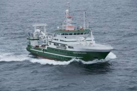
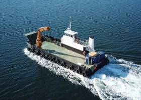
The survey will be conducted by the RV Celtic Explorer (callsign EIGB) which will display appropriate lights and signals.
The vessel will be towing a high headline GOV 36/47 demersal trawl during fishing operations.
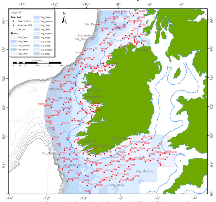
Co-ordinates and approximate locations of these hauls are included in Marine Notice No 47 of 2019, a PDF of which is available to read or download HERE.
The Marine Institute requests that commercial fishing and other marine operators keep a 2nm area around the tow mid-points clear of any gear or apparatus during the survey period between Thursday 31 October and Friday 14 December.
This survey follows the annual Irish Anglerfish and Megrim Survey which was conducted off the West South West and South Coasts in March.
Marine Notice: Geohazard Investigation In Irish Sea
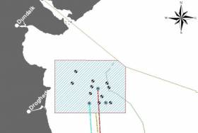
A geohazard investigation to provide support for ongoing research at the Irish Centre for Research in Applied Geosciences (iCRAG) will be undertaken in the Irish Sea from Thursday 24 October until Wednesday 6 November, weather dependent.
The locations of these works at various shipwreck sites off the Louth coast are provided in Marine Notice No 41 of 2019. The equipment and techniques to be used include:
- Surveying using multibeam echo sounders and shallow seismics (pinger);
- Passive acoustic monitors (PAM) deployed at the indicated locations near the seabed to record acoustic data;
- Seismic sparker equipment to reveal subsurface structure and features;
- Sediment core taken at indicated locations to characterise the lithological characteristics of the seabed with grab samples taken within a 3nm range of these locations.
The surveys will be completed on a 24-hour schedule by the RV Celtic Voyager (callsign EIQN) which will display appropriate lights and signals.
Acoustic surveying using a multibeam echo sounder and seismic sub-bottom surveys using a sparker/pinger system will be performed during both day and night operations in accordance with safe operating practices regarding MMO procedures and cognisant of fishing gear.
Sediment sampling using cores will be carried out during daylight hours due to limited ship mobility. PAM units will be deployed and retrieved at both night and day as dictated by survey conditions.
Full details of the survey locations as well as contact information are included in Marine Notice No 41 of 2019, a PDF of which is available to read or download HERE.
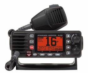
Boaters and mariners have been reminded of the limitations of using mobile phones for emergency communication at sea.
Marine Notice No 40 of 2019 emphasises that mobile phones “should not be considered as a suitable substitute” for marine VHF equipment, which it urges all users of recreational craft to carry.
“Mobile phone coverage at sea is limited and unreliable. Mobile phones are also highly susceptible to failure due to water ingress,” the notice states.
The use of VHF, however, “makes it possible to broadcast to, and receive from, all vessels and coast stations within the vicinity in the event of an emergency”.
Where practicable, the Department of Transport, Tourism and Sport (DTTAS) says recreational craft should maintain a continuous listening watch on VHF channel 16 and DSC watch on VHF channel 70.
Further details are included in Marine Notice No 40 of 2019, a PDF of which is available to read or download HERE.
Small Boat Fishermen Reminded Of Requirements After MCIB Reports Into Fatal Incidents
New Marine Notices from the Department of Transport, Tourism and Sport (DTTAS) remind skippers and crew of small fishing vessels of the requirements set out in the relevant Code of Practice, following the official maritime reports into two fatal incidents off the West Coast last year.
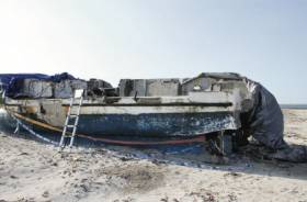
Marine Notice No 38 of 2019 has been published in response to a fatal fishing boat capsize off Co Mayo in the spring of 2018, as previously reported on Afloat.ie.
One man died and two others were recovered some 16 miles off Eagle Island after their vessel, the FV Aisling Patrick, overturned on the afternoon of 10 April last year.
The report from the Marine Casualty Investigation Board (MCIB) clarifies that their vessel had begun to list to starboard and while that was being investigated, a wave struck from the port side and flooded the deck.
Before the skipper could complete a Mayday call, a second wave came from the port side that capsized the boat.
Only one of the three made it into the vessel’s liferaft, while the deceased “was in the water face down and did not make any attempt to swim or stay afloat”.
The upturned hull of the vessel drifted away but was reported off South Uist in Scotland some three weeks after the incident and later inspected.
While the MCIB report did not determine conclusively the cause of the capsize, it was noted that the vessel’s stability was affected due to water ingress — possibly from suboptimal pipe connections — and that the bilge alarm system did not give early warning to the skipper or crew.
Among other findings, it was noted that none of the three men on board was wearing a personal flotation device (PFD), and that the deceased — who had been returning to fishing after a number of years away — had not completed necessary training.
The Marine Notice reminds owners that any major repairs or modifications must comply with the Code of Practice (CoP), and that their vessel must be maintained and operated in accordance with its requirements.
A second Marine Notice, No 39 of 2019, pertains to the investigation into the sinking of a small boat while laying lobster pots off Connemara on 23 May 2018.
As reported here by Lorna Siggins earlier this month, the MCIB found that the boat’s owner, who died in the incident, had purchased a substantial amount of safety equipment — almost none of which was on board at the time.
The notice refers to the same CoP as well as to the advisory published this summer relating to the safety of small vessels engaged in pot fishing.
Regulations For Pilot Transfer Arrangements
The Department of Transport, Tourism and Sport (DTTAS) reminds the owners of ships and fishing vessels, as well as port authorities, pilots, seafarers and more, of the importance of proper pilot transfer arrangements.
These arrangements — with include pilot ladders — must be certified, maintained and rigged in accordance with Chapter V, Regulation 23 of the International Convention for the Safety of Life at Sea (SOLAS).
Ships engaged on voyages in the course of which pilots are likely to be employed shall be provided with pilot transfer arrangements in accordance with the same regulation.
Full details are included in Marine Notice No 33 of 2019, a PDF of which is available to read or download HERE.
Notice On Use Of Lifejackets & Buoyancy Aids On The Water

A new Marine Notice from the Department of Transport, Tourism and Sport reiterates the requirements for lifejackets on pleasure craft and personal water craft.
Superseding a previous notice from spring 2016, the new document explains personal flotation devices or PFDs (both lifejackets and buoyancy aids), the relevant regulations and legal requirements, and instructions for their safe use on the water.
Full details can be found in Marine Notice No 32 of 2019, a PDF of which is available to read or download HERE.
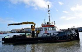
Geophysical surveys are being undertaken in the Irish Sea in outer Dundalk Bay from this week.
The work is required to provide bathymetric and subsurface information for the development of the Oriel Wind Farm project.
Survey work was expected to start yesterday, Tuesday 20 August, with a view to completion by Monday 30 September, though these dates are weather dependent.
The surveys will be completed using the AMS Retriever (Callsign MEHI8), a versatile multi-purpose, shallow draft tug.
This vessel is towing survey equipment up to 100 metres astern and will be restricted in its ability to manoeuvre.
Other vessels are requested to leave a wide berth. The AMS Retriever will be operating from approximately 6am to 9pm during survey works.
Details of co-ordinates of the survey area are included in Marine Notice No 29 of 2019, a PDF of which is available to read or download HERE.
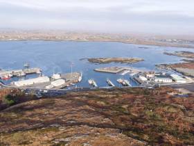
Site investigation works are to be carried out at Rossaveal Fishery Harbour Centre in Co Galway from mid August.
The works will comprise drilling multiple boreholes at the locations detailed in Marine Notice No 28 of 2019, subject to minor variations.
The drill holes will be in navigable waters off Cashla Bay. In keeping with previous Marine Notices with respect to marine construction works, the areas where the drill rig is to be set up must be kept clear of all obstructions including static fishing gear.
A jack-up barge will be moved to the various borehole locations by a tugboat, and will remain on site overnight during the proposed works. All appropriate lights will be displayed by the barge at night. Radio warnings will be transmitted on VHF Channel 16 throughout the works.
Work is expected to commence in mid-August 2019 subject to the contractor’s precise mobilisation timescales, and last for around four weeks, weather permitting.
A PDF of Marine Notice No 28 of 2019 is available to read or download HERE.
Geophysical & Environmental Site Survey Off South Coast

A seabed debris clearance, environmental baseline and habitat assessment site survey will take place in licence SEL 1/11 (Barryroe) from later this month.
Barryroe is located in the North Celtic Sea, some 50 kilometres south of the Port of Cork.
The project is scheduled to commence in mid-August 2019 with the survey vessel Kommandor (callsign MCJO2) anticipated to be working on location for 16 days, excluding transit and any weather delays
Survey operations will be conducted on a 24-hour basis in different phases to include towed and non-towed operations. A fisheries liaison Officer will be on board for the duration of the survey.
Throughout the survey operations, the vessel will be displaying appropriate shapes and lights to indicate that the survey vessel is restricted in its ability to manoeuvre.
All vessels are requested to give this operation a wide berth. A listening watch will be maintained on VHF Channel 16, and the vessel will actively transmit an AIS signal.
Full details of the site survey co-ordinates are included in Marine Notice No 27 of 2019, a PDF of which is available to read or download HERE.
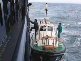
Marine Notice No 25 of 2019 from the Department of Transport, Tourism and Sport advises that there will be a deployment of ADCP current meters on the sea floor in Castletownbere, Co Cork from tomorrow, Thursday 25 July.
Current meters will be mounted in a stainless-steel frame at two locations: Lat 51°38'33.06”N, Long 009°54'42.00"W and Lat 51°38'33.00”N, Long 009°53'43.68”W.
The stainless-steel frame will be deployed from vessel An tOileanach (Callsign EI5930) for 14 days from tomorrow, subject to weather.
Surface spar-style buoys will be used to mark locations. Buoys will be a 700mm diameter yellow buoy of height approximately 1m above the water line.
The buoys will be fitted with a flashing LED light with a range of 2-3 nautical miles. The light will be set to flash 3 times every 10 seconds (duration of flash 0.3 seconds).


 linking Spain.")


 Michael Murphy Schull Harbour Sailing Club (SHSC), Eric Coogan Heineken Ireland, Mark Murphy, Commodore SHSC, Jack Allen SHSC, Carmel O'Regan SHSC, Cornelious Ndlovu, Schull Harbour Hotel Operations Manager and Derval Murphy SHSC")


