


Displaying items by tag: ADCP
TechWorks Marine Deploying Acoustic Doppler Current Profilers Off Kerry Coast for Irish Water Survey
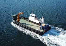
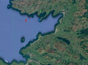
TechWorks Marine plans to deploy four trawl-resistant bottom mounted acoustic Doppler current profilers (ADCP) frames in Castlemaine and Valentia off the coast of Co Kerry from this Monday 7 February.
Weather permitting, the Ocean Navigator (callsign EI018) will deploy the four trawl-resistant, bottom-mounted ADCPs frames — each of around one square metre in area — on the seabed for a minimum of one month and a maximum of two months, between this week and Monday 21 February.
They will be used to carry out water quality sampling surveys as well as vessel-mounted ADCP surveys at the same time as the deployments and these are tide and weather dependent and may cause a slight delay in the recovery of the seabed frames.
The ADCPs will be measuring currents through the water column at each location over the course of their month-long deployment. This data will be used to validate a hydrodynamic model being developed of the area for Irish Water.
There will be no surface marker during the extent of deployment so vessel traffic will not need to avoid the area but should be aware of its presence. Throughout operations, the Ocean Navigator will be displaying appropriate lights and shapes.
Details of the exact locations of the ADCP frames and other information for mariners are included in Marine Notice No 08 of 2022, which can be downloaded below.
The deployment of an Acoustic Doppler Current Profiler (ADCP) sub-surface installation by University College Dublin, which was scheduled to take place between 15 - 21 October 2020 as Afloat previously reported, will now take place on 7 November 2020.
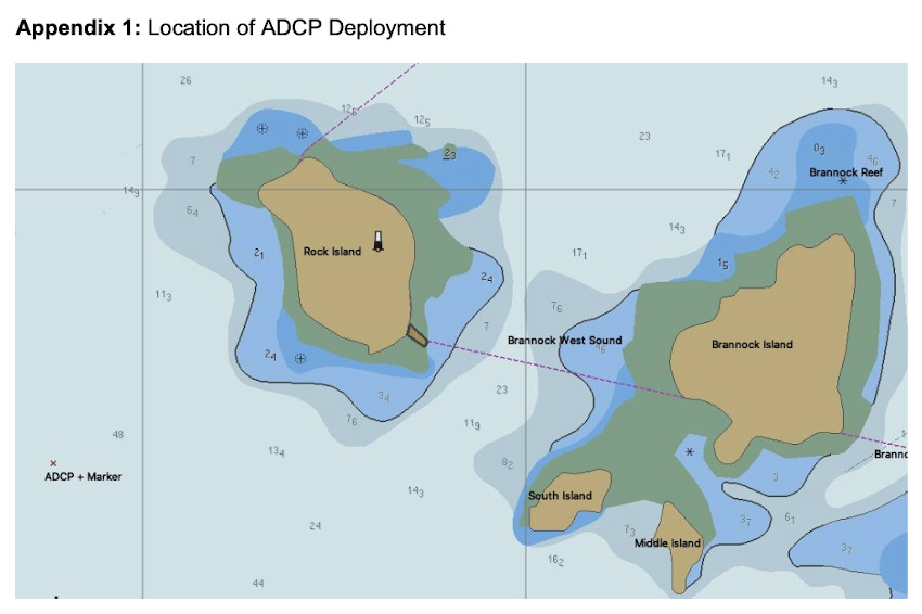
The deployment will occur approximately 0.60 Nautical Miles from Rock Island lighthouse in a direction of 235° (see Appendix 1). The exact location co-ordinates are as follows:
Latitude: 53°08' 57.4"N
Longitude: 009°52' 23.4"W
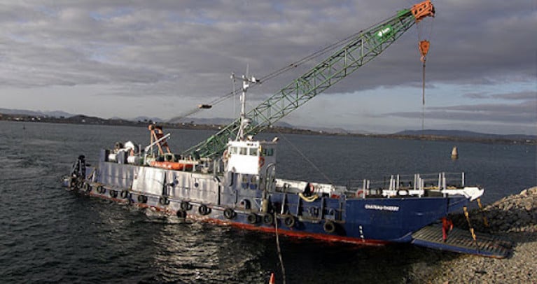
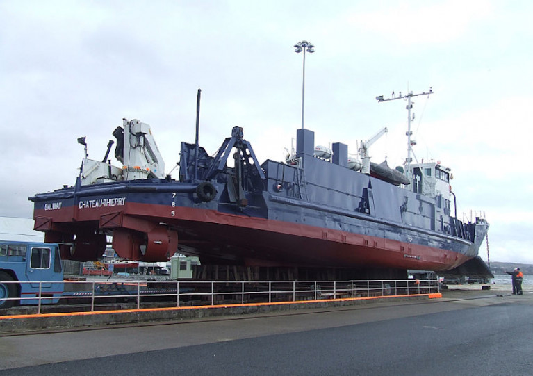
The deployment will be carried out by the 'MV Chateau-Thierry'
Yellow spherical marker buoys, 40 cm in diameter will be used. They will flash yellow every 5 seconds.
An acoustic Doppler current profiler (ADCP) is a hydroacoustic current meter similar to a sonar, used to measure water current velocities over a depth range using the Doppler effect of sound waves scattered back from particles within the water column.
The UCD Highwave Project aims to use statistics and fluid mechanics to explore fundamental questions in wave breaking.
Marine Notice: ADCP Deployment Off Inis Mór For Highwave Project
University College Dublin have been set to deploy an Acoustic Doppler Current Profiler (ADCP) off Inis Mór in the Aran Islands between today, Thursday 15 October, and next Wednesday 21 October as part of the Highwave project.
The university previously deployed an ADCP in February as par of the same ocean wave data modelling project.
Thos latest deployment, from the MV Chateau-Thierry (callsign EIHK6), will be some 0.6 nautical miles from Rock Island lighthouse — at 53°08’57.4” N, 009°52’23.4” W. The vessel will display appropriate lights and signals.
Navigational warnings will be issued by radio when the deployment of the marker buoys takes place. These buoys will be yellow spherical markers, 40cm in diameter and flashing yellow every five seconds.
Marine Notice: ADCP Deployment Off Aran Islands
The Department of Transport, Tourism and Sport advises that University College Dublin intends to deploy an Acoustic Doppler Current Profiler (ADCP) sub-surface installation off the Aran Islands this Friday 28 February, weather permitting.
The deployment will occur around 0.6 nautical miles from Eeragh Lighthouse on Rock Island, off Inishmore, in a direction of 235°. The exact location co-ordinates are 53° 08' 34.437" N, 9° 52' 14.040" W.
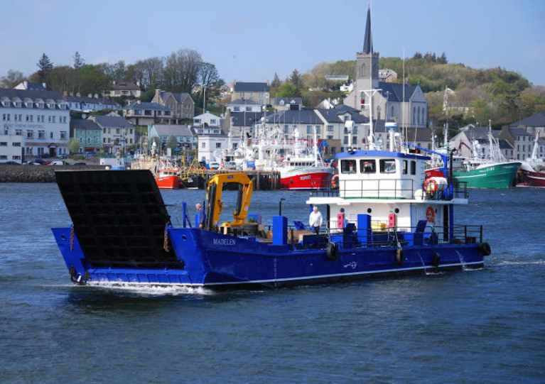
The one-day deployment will be carried out by the MV Madelen (Callsign: EI4990). The vessel will display appropriate lights and signals.
Navigational warnings will be issued by radio when the marker buoy deployment takes place. Yellow, spherical marker buoys, 40cm in diameter, will be used. They will flash amber every five seconds.
For more information on this deployment visit www.highwave-project.eu
Marine Notice No 25 of 2019 from the Department of Transport, Tourism and Sport advises that there will be a deployment of ADCP current meters on the sea floor in Castletownbere, Co Cork from tomorrow, Thursday 25 July.
Current meters will be mounted in a stainless-steel frame at two locations: Lat 51°38'33.06”N, Long 009°54'42.00"W and Lat 51°38'33.00”N, Long 009°53'43.68”W.
The stainless-steel frame will be deployed from vessel An tOileanach (Callsign EI5930) for 14 days from tomorrow, subject to weather.
Surface spar-style buoys will be used to mark locations. Buoys will be a 700mm diameter yellow buoy of height approximately 1m above the water line.
The buoys will be fitted with a flashing LED light with a range of 2-3 nautical miles. The light will be set to flash 3 times every 10 seconds (duration of flash 0.3 seconds).
Marine Notices: ADCP Deployment In Waterford Harbour, EirGrid Interconnector Cable Survey In Irish Sea
TechWorks Marine Ltd is deploying trawl-resistant bottom mounted Acoustic Doppler Current Profiler (ADCP) frames in Waterford Harbour this week.
It is anticipated that the ADCPs will be deployed between today, Monday 8 July, and this Friday 12 July, depending on the weather. If the deployment is delayed due to the weather, it will be carried out on the next viable tide and weather window. Update: the ADCPs will now be deployed on or after Thursday 18 July.
The frames will be deployed from the vessel James (callsign EITT2). The frames will be on the seafloor for a minimum period of one calendar month and a maximum period of two months (weather permitting).
The ADCPs will be measuring currents through the water column at each location over the deployment. This data will be used to validate a hydrodynamic model of the area being developed for Irish Water.
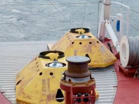
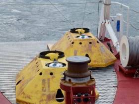
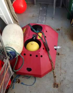
Each frame will have one ADCP sensor, an acoustic pinger, an acoustic release and a rigid recovery buoy.
The frames are approximately 1m2 and will remain on the seafloor for a period of up to 30 days, after which the frame will be retrieved using the acoustic release and recovery buoy.
There will be no surface marker during the extent of deployment so vessel traffic will not need to avoid the area but should be aware of its presence.
Details of the relevant co-ordinates are included in Marine Notice No 22 of 2019, a PDF of which is available to read or download HERE.
Meanwhile, planned cable survey works on the EirGrid East West Interconnector are being carried out by the vessel Deep Helder (callsign PBYU) until this Thursday 11 July. During this survey, the vessel will be deploying underwater survey equipment along a thin 50m corridor.
Fishermen are advised not to leave any static fishing equipment in the vicinity of the survey route (250 metres) and keep a safe distance of at least one nautical mile from the survey vessels that will be operating with towed equipment and will have restricted manoeuvrability.
In addition, the survey vessel Ping will carry out operations in the near-shore waters off Rush, Co Dublin from next Monday 15 July. Near-shore survey operations will take place between beach HW mark and the 10m water depth contour.
Details of co-ordinates and survey contacts are included in Marine Notice No 21 of 2019, a PDF of which is available to read or download HERE.
Acoustic Doppler Current Profilers Deployed In Lough Swilly
The Department of Transport, Tourism and Sport (DTTAS) advises that TechWorks Marine has deployed four trawl-resistant, bottom-mounted Acoustic Doppler Current Profilers (ADCPs) frames throughout Lough Swilly.
The frames deployed on Wednesday 20 February will be on the seafloor for a minimum period of one calendar month and a maximum period of two months (weather permitting).
Water sampling surveys are required to be carried out at the same time as the deployments and these are tide and weather dependent, and may cause a slight delay in recovery, hence the two-month deployment period.
The ADCPs will be measuring currents through the water column at each location over the month-long deployment. This data will be used to validate a hydrodynamic model of the area being developed for Irish Water.
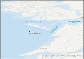
The deployment locations as noted in Marine Notice No 5 of 2019 are (degrees, minutes, seconds) WGS84 as follows:
- ADCP 1: 55° 12' 59.5" N, 7° 34' 37.2" W
- ADCP 2: 55° 06' 51.9" N, 7° 29' 02.7" W
- ADCP 3: 55° 03' 52.4" N, 7° 32' 11.3" W
- ADCP 4: 55° 01' 17.5" N, 7° 32' 55.4" W
Each frame will have an ADCP sensor (for waves and currents), acoustic release, rigid recovery buoy, acoustic pinger and grapple line. The frames are approximately 1m2 and will remain on the seafloor for a period of up to 30 days, after which the frame will be retrieved by the acoustic release by the retrieval team of a pop-up buoy allowing for its recovery or by a grapple line recovery method.
During the extent of the deployment, ADCP frames 1, 2 and 3 will have a surface marker. The ADCP 1 and 2 will have a red in colour surface buoy and ADCP 3 will have a yellow in colour surface buoy. There will be no surface marker for ADCP 4 so vessel traffic will not need to avoid its location but should be aware of its presence.
Marine Notice No 12 of 2018 advises that the Marine Institute was scheduled to deploy a bottom-mounted acoustic Doppler current profiler (ADCP) on the Aran prawn ground today, Monday 26 March.
The ADCP will be recovered in May and will remain in place for the duration. The purpose of this deployment is to measure water current speed over a depth range using the Doppler effect of sound waves scattered from particles within the water column.
The ADCP was set to be deployed at Latitude 53°46.133 N and Longitude 9°47.4 W by the RV Celtic Voyager (Callsign EIQN) listening on VHF Channel 16.
As this is sensitive scientific equipment, it is requested that fishermen and marine operators engaged in such activities as bottom trawling or laying of static gear avoid the location concerned to avoid damaging the equipment or damaging fishing gear.
#MarineNotice - TechWorks Marine are deploying three trawl-resistant bottom mounted acoustic Doppler current profiler (ADCP) frames at three locations in Donegal Bay from this week.
The frames, which will be on the sea floor between now and June, are being deployed as part of the oceanographic monitoring programme for the Department of Agriculture, Food and the Marine.
Scheduled for deployment earlier this week on Monday 27 March, the frames will be left in the water for a minimum of one month before being retrieved.
The vessel Dulra na Mara (Callsign EIFS6) will be used for both deployment and collection of the frames. The vessel will be listening on VHF Channel 16 throughout the project.
The frames are 2m by 1m and will remain on the seafloor for a period of up to 90 days, after which each frame will be retrieved by the acoustic release of a pop-up buoy allowing for its recovery.
There will be no surface marker during the extent of deployment so vessel traffic will not need to avoid the area but should be aware of its presence.
A map and co-ordinates of the frame placement points are included in Marine Notice No 14 of 2017, a PDF of which is available to read or download HERE.
Marine Notice: Deployment Of Ocean-Bottom Seismometers
#MarineNotice - The latest Marine Notice from the Department of Transport, Tourism and Sport (DTTAS) advises that marine scientists from the Dublin Institute of Advanced Studies (DIAS) are deploying a tsunameter close to the new location of the M4 weather buoy off the Donegal coast.
In addition to the tsunameter, they will also deploy a sub-surface buoy with an acoustic Doppler current profiler (ADCP) mounted on it, as well as pressure sensors clamped to a moored string to measure pressure variations at depth. This system will be deployed in proximity to the tsunameter location but not too close to avoid tangling.
The tsunameter and system used for the ADCP and the pressure string sensors is scheduled to be be deployed imminently from the RV Celtic Voyager (Callsign: EIQN) at latitude 54°59.892 N, longitude 009°58.14 W, at a depth of 119m adjacent to M4 weather buoy.
As this is sensitive scientific equipment, it is requested that fisherman and marine operators engaged in such activities as bottom trawling or laying of static gear avoid the locations concerned to avoid damaging the equipment or damaging fishing gear.


 linking Spain.")


 Michael Murphy Schull Harbour Sailing Club (SHSC), Eric Coogan Heineken Ireland, Mark Murphy, Commodore SHSC, Jack Allen SHSC, Carmel O'Regan SHSC, Cornelious Ndlovu, Schull Harbour Hotel Operations Manager and Derval Murphy SHSC")


