Menu

Ireland's sailing, boating & maritime magazine

Displaying items by tag: rockfall

The popular Dalkey Island seasonal ferryboat has stopped service due to a partial collapse of a cliff-face underneath a footpath leading to the pier at Coliemore Harbour, Co. Dublin, writes Jehan Ashmore.

The ferry operator, Ken Cunningham said "unfortunately due to an incident in the harbour I cannot operate the ferry this weekend, its under investigation right now with DLRCoCo because part of the wall fell out where the walkway is and it is unsafe for anyone too walk down"

He added "I'm sorry for any inconvenience caused to anyone who was planning a trip over to the island this weekend. Hopefully, I won't be out of action for too long".

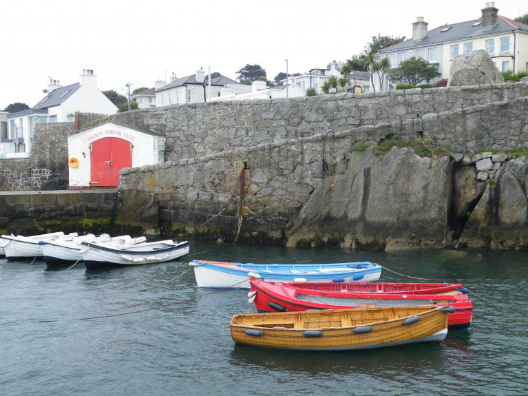
Directly below the footpath wall that provides access from Coliemore Road, is where the jagged chunk of cliff-face sheared off below into the harbour which during medieval times acted as the Port of Dublin. The only commercial operation using the beautiful stone-cut harbour now is the 'Ken The Ferryman' service until this week's rock-fall incident (see: facebook's close up photo).

A close up of the affected cliff-face at Coliemore HarbourA close up of the affected cliff-face at Coliemore Harbour

The stretch of water across Dalkey Sound is a mere 300m between the mainland harbour and the landing slipway on the island which together in 2014 were upgraded by Dun Laoghaire-Rathdown County Council (DLRCoCo). For more details of these works (see p.23) of 'Maritime' Dalkey coverage in the Dalkey Community Council newsletters, also features the resumption of the ferry service after three years absence.  

Due to Covid-19 restrictions the service was delayed from beginning earlier this season using instead of the Lilly Rose a new larger replacement passenger boat, Gemma but now currently off-service due to cliff rock-fall.

The ferryboat service at Coliemore Harbour is located less than a mile from Dalkey which is a designated 'Heritage Town' with its scenic coastline along the Dublin Riviera.

It is also along the harbour's footpath wall where local youths have been gathering and jumping off directly into the water below, however the fallen rock is now in this same area posing a danger to such activity. In addition the rock is a danger to nearby timber and fibreglass built moored boats.

DLRCoCo has blocked of Coliemore Harbour's walkway leading to the ferry pier with signs stating no unauthorised access and danger warnings of 'falling rocks' and 'closed due to repair works needed'. Access remains open but only to the slip and adjoining second pier with anglers given the mackeral season is underway.

The stretch of water between Coliemore and the island is named Dalkey Sound which is a mere 300m wide and is linked by the traditional ferryboat service.

In addition the affected walkway has also led to no access to Dalkey Rowing Club's premises and so coastal rowing of 'skiff' boats have been cancelled. 

Ken the Ferryman is the sole operator providing exclusively the Department of Marine inspected and licensed passenger-boat service off the south Dublin suburb which has become more famous as it is host to the annual Dalkey Book Festival. This year's 10th festival, however was postponed due to Covid-19 public health restrictions.

Published in Dublin Bay

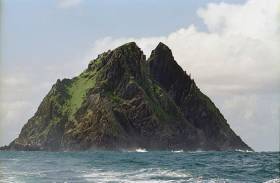
#SkelligMichael - Skellig Michael’s opening for summer visitors on 14 May has been cast into doubt by concerns over of a number of unstable large rocks following a rockfall discovered earlier this month.

Safety contractors and OPW staff are currently assessing the situation at the Unesco World Heritage site, a major location in the upcoming blockbuster movie Star Wars: The Last Jedi.

But according to The Irish Times, the filming activity and increased visitor numbers are not to blame for the damage on what’s been dubbed ‘Star Wars Island’ — more likely caused by heavy winter storms and burrowing by the island’s rabbits.

As previously reported on Afloat.ie, evidence of a “deeply worrying” rockfall was found during pre-season checks by OPW staff on Friday 7 April.

Published in Island News

#IslandNews - A serious rockfall on Skellig Michael has been described as “deeply worrying” by a senior conservationist.

RTÉ News reports that the rockfall was discovered during pre-season checks by OPW staff last Friday (7 April), close to accommodation huts on the Co Kerry island’s Lighthouse Road.

The Unesco World Heritage site is due to open for visitors next month, with big numbers expected in the wake of its featuring in the new Star Wars movies.

OPW senior conservation architect Grellan Rourke said that if some of the “very large” rocks had come down on top of the huts “there would have been a significant threat to anyone inside”.

Experts will examine the rock slopes in question, with no confirmation of whether this would affect Skellig Michael’s opening date for visitors.

RTÉ News has more on the story HERE.

Published in Island News
Tagged under

Rockfalls on Sceilig Mhichíl, (also known as Skellig Michael or Great Skellig Island), Co. Kerry have caused a breach to the Lighthouse Road wall, which forms the sole access to the monastic site from the island’s landing. The damage is reported as being significant and extensive, and the steep ground above the roadway may be subject to further rock falls following the heavy rains that have occurred over the winter months. This must be examined and repaired as required before public access is permitted.

The news was issued by The Department of Transport, Tourism and Sport to all Masters, Skippers, Seafarers, Fishers, Passenger Boat Operators and Owners and Users of Recreational Craft in Marine Notice this afternoon.

The OPW has advised that the island remains in a highly unstable and extremely dangerous condition and should, under no circumstances, be accessed by anyone other than the OPW project team and their contractors involved with the assessment of the damage and repairs. Any unauthorised persons landing on the island before the necessary repairs have been carried out would be exposed to considerable risk.

The Department of Transport, Tourism and Sport wishes to advise that, until further notice, persons should not be landed on the island from any vessel without the express consent of the OPW.

This Marine Notice will be cancelled at such time that the OPW advise that the repairs have been completed and the island has been re-opened to the public.

Published in Marine Warning
Tagged under

Ireland's offshore islands

Around 30 of Ireland's offshore islands are inhabited and hold a wealth of cultural heritage.

A central Government objective is to ensure that sustainable vibrant communities continue to live on the islands.

Irish offshore islands FAQs

Technically, it is Ireland itself, as the third largest island in Europe.

Ireland is surrounded by approximately 80 islands of significant size, of which only about 20 are inhabited.

Achill island is the largest of the Irish isles with a coastline of almost 80 miles and has a population of 2,569.

The smallest inhabited offshore island is Inishfree, off Donegal.

The total voting population in the Republic's inhabited islands is just over 2,600 people, according to the Department of Housing.

Starting with west Cork, and giving voting register numbers as of 2020, here you go - Bere island (177), Cape Clear island (131),Dursey island (6), Hare island (29), Whiddy island (26), Long island, Schull (16), Sherkin island (95). The Galway islands are Inis Mór (675), Inis Meáin (148), Inis Oírr (210), Inishbofin (183). The Donegal islands are Arranmore (513), Gola (30), Inishboffin (63), Inishfree (4), Tory (140). The Mayo islands, apart from Achill which is connected by a bridge, are Clare island (116), Inishbiggle (25) and Inishturk (52).

No, the Gaeltacht islands are the Donegal islands, three of the four Galway islands (Inishbofin, like Clifden, is English-speaking primarily), and Cape Clear or Oileán Chléire in west Cork.

Lack of a pier was one of the main factors in the evacuation of a number of islands, the best known being the Blasket islands off Kerry, which were evacuated in November 1953. There are now three cottages available to rent on the Great Blasket island.

In the early 20th century, scholars visited the Great Blasket to learn Irish and to collect folklore and they encouraged the islanders to record their life stories in their native tongue. The three best known island books are An tOileánach (The Islandman) by Tomás Ó Criomhthain, Peig by Peig Sayers, and Fiche Blian ag Fás (Twenty Years A-Growing) by Muiris Ó Súilleabháin. Former taoiseach Charles J Haughey also kept a residence on his island, Inishvickillaune, which is one of the smaller and less accessible Blasket islands.

Charles J Haughey, as above, or late Beatle musician, John Lennon. Lennon bought Dorinish island in Clew Bay, south Mayo, in 1967 for a reported £1,700 sterling. Vendor was Westport Harbour Board which had used it for marine pilots. Lennon reportedly planned to spend his retirement there, and The Guardian newspaper quoted local estate agent Andrew Crowley as saying he was "besotted with the place by all accounts". He did lodge a planning application for a house, but never built on the 19 acres. He offered it to Sid Rawle, founder of the Digger Action Movement and known as the "King of the Hippies". Rawle and 30 others lived there until 1972 when their tents were burned by an oil lamp. Lennon and Yoko Ono visited it once more before his death in 1980. Ono sold the island for £30,000 in 1984, and it is widely reported that she donated the proceeds of the sale to an Irish orphanage


Yes, Rathlin island, off Co Antrim's Causeway Coast, is Ireland's most northerly inhabited island. As a special area of conservation, it is home to tens of thousands of sea birds, including puffins, kittiwakes, razorbills and guillemots. It is known for its Rathlin golden hare. It is almost famous for the fact that Robert the Bruce, King of Scots, retreated after being defeated by the English at Perth and hid in a sea cave where he was so inspired by a spider's tenacity that he returned to defeat his enemy.

No. The Aran islands have a regular ferry and plane service, with ferries from Ros-a-Mhíl, south Connemara all year round and from Doolin, Co Clare in the tourist season. The plane service flies from Indreabhán to all three islands. Inishbofin is connected by ferry from Cleggan, Co Galway, while Clare island and Inishturk are connected from Roonagh pier, outside Louisburgh. The Donegal islands of Arranmore and Tory island also have ferry services, as has Bere island, Cape Clear and Sherkin off Cork. How are the island transport services financed? The Government subsidises transport services to and from the islands. The Irish Coast Guard carries out medical evacuations, as to the RNLI lifeboats. Former Fianna Fáíl minister Éamon Ó Cuív is widely credited with improving transport services to and from offshore islands, earning his department the nickname "Craggy island".

Craggy Island is an bleak, isolated community located of the west coast, inhabited by Irish, a Chinese community and one Maori. Three priests and housekeeper Mrs Doyle live in a parochial house There is a pub, a very small golf course, a McDonald's fast food restaurant and a Chinatown... Actually, that is all fiction. Craggy island is a figment of the imagination of the Father Ted series writers Graham Linehan and Arthur Mathews, for the highly successful Channel 4 television series, and the Georgian style parochial house on the "island" is actually Glenquin House in Co Clare.

Yes, that is of the Plassey, a freighter which was washed up on Inis Oírr in bad weather in 1960.

There are some small privately owned islands,and islands like Inishlyre in Co Mayo with only a small number of residents providing their own transport. Several Connemara islands such as Turbot and Inishturk South have a growing summer population, with some residents extending their stay during Covid-19. Turbot island off Eyrephort is one such example – the island, which was first spotted by Alcock and Brown as they approached Ireland during their epic transatlantic flight in 1919, was evacuated in 1978, four years after three of its fishermen drowned on the way home from watching an All Ireland final in Clifden. However, it is slowly being repopulated

Responsibility for the islands was taking over by the Department of Rural and Community Development . It was previously with the Gaeltacht section in the Department of Media, Tourism, Arts, Culture, Sport and the Gaeltacht.

It is a periodic bone of contention, as Ireland does not have the same approach to its islands as Norway, which believes in right of access. However, many improvements were made during Fianna Fáíl Galway West TD Éamon Ó Cuív's time as minister. The Irish Island Federation, Comdháil Oileáin na hÉireann, represents island issues at national and international level.

The 12 offshore islands with registered voters have long argued that having to cast their vote early puts them at a disadvantage – especially as improved transport links mean that ballot boxes can be transported to the mainland in most weather conditions, bar the winter months. Legislation allowing them to vote on the same day as the rest of the State wasn't passed in time for the February 2020 general election.

Yes, but check tide tables ! Omey island off north Connemara is accessible at low tide and also runs a summer race meeting on the strand. In Sligo, 14 pillars mark the way to Coney island – one of several islands bearing this name off the Irish coast.

Cape Clear or Oileán Chléire is the country's most southerly inhabited island, eight miles off the west Cork coast, and within sight of the Fastnet Rock lighthouse, also known as the "teardrop of Ireland".
Skellig Michael off the Kerry coast, which has a monastic site dating from the 6th century. It is accessible by boat – prebooking essential – from Portmagee, Co Kerry. However, due to Covid-19 restrictions, it was not open to visitors in 2020.
All islands have bird life, but puffins and gannets and kittiwakes are synonymous with Skellig Michael and Little Skellig. Rathlin island off Antrim and Cape Clear off west Cork have bird observatories. The Saltee islands off the Wexford coast are privately owned by the O'Neill family, but day visitors are permitted access to the Great Saltee during certain hours. The Saltees have gannets, gulls, puffins and Manx shearwaters.
Vikings used Dublin as a European slaving capital, and one of their bases was on Dalkey island, which can be viewed from Killiney's Vico road. Boat trips available from Coliemore harbour in Dalkey. Birdwatch Ireland has set up nestboxes here for roseate terns. Keep an eye out also for feral goats.
Plenty! There are regular boat trips in summer to Inchagoill island on Lough Corrib, while the best known Irish inshore island might be the lake isle of Innisfree on Sligo's Lough Gill, immortalised by WB Yeats in his poem of the same name. Roscommon's Lough Key has several islands, the most prominent being the privately-owned Castle Island. Trinity island is more accessible to the public - it was once occupied by Cistercian monks from Boyle Abbey.

©Afloat 2020