Menu

Ireland's sailing, boating & maritime magazine

Displaying items by tag: €320m expansion

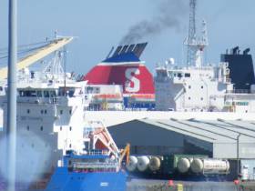
The Dublin Port Company is seeking planning permission for an estimated €320 million worth of projects that make up the second stage of its main expansion plan.

The State-owned company, writes The Irish Times, is working on a masterplan that will bring it to “its maximum and ultimate capacity” by 2040, according to its chief executive, Eamonn O’Reilly.

The company said on Tuesday that it has asked An Bord Pleanála for permission to go ahead with the second stage of the plan, which involves five key projects scheduled to be finished by 2035.

“If we were building all of it today it would cost us €320 million,” Mr O’Reilly estimated. He cautioned that it would not be possible to give a final figure until Dublin Port knew what conditions could be attached to any planning permission it received and had calculated for both detailed design and construction inflation.

The company’s board recently approved a proposal to allow it borrow an extra €300 million if needed.

The masterplan’s second stage (MP2 Project) provides for a new roll-on roll-off jetty for ferries up to 240m-long, lengthening an existing berth for container ships, redeveloping an oil berth so it can handle container traffic, re-orienting another existing berth and consolidating passenger terminals.

For more including the company's consultation process click this link. 

In addition Afloat.ie adds DPC has announced is lodging an application for permission with An Bord Pleanála for its MP2 Project, the second major capital development project from the Port’s Masterplan 2040.

It follows consultation with stakeholders, including the local community, customers, State agencies, Government departments and other public bodies.

Public information days (see below) will be held in local communities over the coming weeks with details of the proposed development plans on view.

Additional Capacity for Future Growth 

The MP2 Project is the second of three Strategic Infrastructure Development projects required to deliver the vision of Masterplan 2040.  This vision sees Dublin Port reaching its ultimate capacity by 2040 with no additional infill of Dublin Bay. The need now for the MP2 Project arises from both the level of future growth DPC is projecting and the time required to complete the development works (2020 – 2035).

By reconfiguring how existing facilities and lands are currently used, the MP2 Project will create additional capacity for almost one-third of the projected increases in Dublin Port’s Ro-Ro (truck) and Lo-Lo (container) traffic between now and 2040.

When complete, the MP2 Project will also increase Dublin Port’s capacity to handle growing ship sizes by providing up to three longer, deeper river berths capable of taking Ro-Ro ferries and Lo-Lo container ships measuring up to 240m in length.

Port Heritage & Community Gain

The MP2 Project also includes provision for a publicly accessible Heritage Zone at the eastern end of the Port. 

This will include a new structure or ‘Marker’ incorporating the original lighthouse bell and lantern from the pier head at the end of the long gone 19th century eastern breakwater. The Marker includes a Viewing and Interpretive Deck, and beneath it a small performance space or amphitheatre. The proposal also features the installation of a Sea Organ, a musical instrument made from a series of pipes with whistle openings installed into the land boundary.  The Heritage Zone will be accessible by cyclists and pedestrians along the new 4km greenway on the northern fringe of the port overlooking the Tolka Estuary.  Construction of the greenway will commence later this year.

In the event that permission is granted for the MP2 Project, a Community Gain initiative is also proposed as part of the application that would see DPC establish a €1 million trust fund for Dublin City Council to develop a city farm in the vicinity of the Port, intended to enhance the local community and benefit the wider city through educational, volunteering and collaboration opportunities. In addition, DPC would establish a €1 million trust fund for St. Joseph’s Co-Ed Primary School in East Wall, intended to benefit the school community closest to the development site.

Public Consultation

The application for permission, the Environmental Impact Assessment Report and the Natura Impact Statement, will be available to inspect during public opening hours for seven weeks from 19th July 2019 at: -

  • The Offices of An Bord Pleanála 64 Marlborough Street, Dublin 1.
  • The Offices of Dublin City Council, Civic Offices, Woodquay, Dublin 8.
  • The Offices of Dublin Port Company, Port Centre, Dublin Port, Alexandra Road, Dublin 1.  

The application may also be viewed / downloaded from the project website: www.dublinportmp2.ie (which at timing of writing is 'coming soon'). 

Public Information Days will also take place in the following locations, where the MP2 Project Team will be available to discuss the project in person and where the application documents will be on view. 

CLONTARF

Scoil Uí Chonaill GAA Club, 95 Clontarf Road

Tuesday, 23rd July, 2019

2-8pm

EAST WALL

Seán O'Casey Community Centre, St. Mary’s Road

Wednesday, 24th July, 2019

2-8pm

RINGSEND

Clanna Gael Fontenoy GAA Club, Sean Moore Road

Thursday, 25th July, 2019

2-8pm


Submissions or observations may be made only to An Bord Pleanála up until 5.30pm on 5th September 2019. See www.pleanala.ie for further details.

Published in Dublin Port

Ireland's offshore islands

Around 30 of Ireland's offshore islands are inhabited and hold a wealth of cultural heritage.

A central Government objective is to ensure that sustainable vibrant communities continue to live on the islands.

Irish offshore islands FAQs

Technically, it is Ireland itself, as the third largest island in Europe.

Ireland is surrounded by approximately 80 islands of significant size, of which only about 20 are inhabited.

Achill island is the largest of the Irish isles with a coastline of almost 80 miles and has a population of 2,569.

The smallest inhabited offshore island is Inishfree, off Donegal.

The total voting population in the Republic's inhabited islands is just over 2,600 people, according to the Department of Housing.

Starting with west Cork, and giving voting register numbers as of 2020, here you go - Bere island (177), Cape Clear island (131),Dursey island (6), Hare island (29), Whiddy island (26), Long island, Schull (16), Sherkin island (95). The Galway islands are Inis Mór (675), Inis Meáin (148), Inis Oírr (210), Inishbofin (183). The Donegal islands are Arranmore (513), Gola (30), Inishboffin (63), Inishfree (4), Tory (140). The Mayo islands, apart from Achill which is connected by a bridge, are Clare island (116), Inishbiggle (25) and Inishturk (52).

No, the Gaeltacht islands are the Donegal islands, three of the four Galway islands (Inishbofin, like Clifden, is English-speaking primarily), and Cape Clear or Oileán Chléire in west Cork.

Lack of a pier was one of the main factors in the evacuation of a number of islands, the best known being the Blasket islands off Kerry, which were evacuated in November 1953. There are now three cottages available to rent on the Great Blasket island.

In the early 20th century, scholars visited the Great Blasket to learn Irish and to collect folklore and they encouraged the islanders to record their life stories in their native tongue. The three best known island books are An tOileánach (The Islandman) by Tomás Ó Criomhthain, Peig by Peig Sayers, and Fiche Blian ag Fás (Twenty Years A-Growing) by Muiris Ó Súilleabháin. Former taoiseach Charles J Haughey also kept a residence on his island, Inishvickillaune, which is one of the smaller and less accessible Blasket islands.

Charles J Haughey, as above, or late Beatle musician, John Lennon. Lennon bought Dorinish island in Clew Bay, south Mayo, in 1967 for a reported £1,700 sterling. Vendor was Westport Harbour Board which had used it for marine pilots. Lennon reportedly planned to spend his retirement there, and The Guardian newspaper quoted local estate agent Andrew Crowley as saying he was "besotted with the place by all accounts". He did lodge a planning application for a house, but never built on the 19 acres. He offered it to Sid Rawle, founder of the Digger Action Movement and known as the "King of the Hippies". Rawle and 30 others lived there until 1972 when their tents were burned by an oil lamp. Lennon and Yoko Ono visited it once more before his death in 1980. Ono sold the island for £30,000 in 1984, and it is widely reported that she donated the proceeds of the sale to an Irish orphanage


Yes, Rathlin island, off Co Antrim's Causeway Coast, is Ireland's most northerly inhabited island. As a special area of conservation, it is home to tens of thousands of sea birds, including puffins, kittiwakes, razorbills and guillemots. It is known for its Rathlin golden hare. It is almost famous for the fact that Robert the Bruce, King of Scots, retreated after being defeated by the English at Perth and hid in a sea cave where he was so inspired by a spider's tenacity that he returned to defeat his enemy.

No. The Aran islands have a regular ferry and plane service, with ferries from Ros-a-Mhíl, south Connemara all year round and from Doolin, Co Clare in the tourist season. The plane service flies from Indreabhán to all three islands. Inishbofin is connected by ferry from Cleggan, Co Galway, while Clare island and Inishturk are connected from Roonagh pier, outside Louisburgh. The Donegal islands of Arranmore and Tory island also have ferry services, as has Bere island, Cape Clear and Sherkin off Cork. How are the island transport services financed? The Government subsidises transport services to and from the islands. The Irish Coast Guard carries out medical evacuations, as to the RNLI lifeboats. Former Fianna Fáíl minister Éamon Ó Cuív is widely credited with improving transport services to and from offshore islands, earning his department the nickname "Craggy island".

Craggy Island is an bleak, isolated community located of the west coast, inhabited by Irish, a Chinese community and one Maori. Three priests and housekeeper Mrs Doyle live in a parochial house There is a pub, a very small golf course, a McDonald's fast food restaurant and a Chinatown... Actually, that is all fiction. Craggy island is a figment of the imagination of the Father Ted series writers Graham Linehan and Arthur Mathews, for the highly successful Channel 4 television series, and the Georgian style parochial house on the "island" is actually Glenquin House in Co Clare.

Yes, that is of the Plassey, a freighter which was washed up on Inis Oírr in bad weather in 1960.

There are some small privately owned islands,and islands like Inishlyre in Co Mayo with only a small number of residents providing their own transport. Several Connemara islands such as Turbot and Inishturk South have a growing summer population, with some residents extending their stay during Covid-19. Turbot island off Eyrephort is one such example – the island, which was first spotted by Alcock and Brown as they approached Ireland during their epic transatlantic flight in 1919, was evacuated in 1978, four years after three of its fishermen drowned on the way home from watching an All Ireland final in Clifden. However, it is slowly being repopulated

Responsibility for the islands was taking over by the Department of Rural and Community Development . It was previously with the Gaeltacht section in the Department of Media, Tourism, Arts, Culture, Sport and the Gaeltacht.

It is a periodic bone of contention, as Ireland does not have the same approach to its islands as Norway, which believes in right of access. However, many improvements were made during Fianna Fáíl Galway West TD Éamon Ó Cuív's time as minister. The Irish Island Federation, Comdháil Oileáin na hÉireann, represents island issues at national and international level.

The 12 offshore islands with registered voters have long argued that having to cast their vote early puts them at a disadvantage – especially as improved transport links mean that ballot boxes can be transported to the mainland in most weather conditions, bar the winter months. Legislation allowing them to vote on the same day as the rest of the State wasn't passed in time for the February 2020 general election.

Yes, but check tide tables ! Omey island off north Connemara is accessible at low tide and also runs a summer race meeting on the strand. In Sligo, 14 pillars mark the way to Coney island – one of several islands bearing this name off the Irish coast.

Cape Clear or Oileán Chléire is the country's most southerly inhabited island, eight miles off the west Cork coast, and within sight of the Fastnet Rock lighthouse, also known as the "teardrop of Ireland".
Skellig Michael off the Kerry coast, which has a monastic site dating from the 6th century. It is accessible by boat – prebooking essential – from Portmagee, Co Kerry. However, due to Covid-19 restrictions, it was not open to visitors in 2020.
All islands have bird life, but puffins and gannets and kittiwakes are synonymous with Skellig Michael and Little Skellig. Rathlin island off Antrim and Cape Clear off west Cork have bird observatories. The Saltee islands off the Wexford coast are privately owned by the O'Neill family, but day visitors are permitted access to the Great Saltee during certain hours. The Saltees have gannets, gulls, puffins and Manx shearwaters.
Vikings used Dublin as a European slaving capital, and one of their bases was on Dalkey island, which can be viewed from Killiney's Vico road. Boat trips available from Coliemore harbour in Dalkey. Birdwatch Ireland has set up nestboxes here for roseate terns. Keep an eye out also for feral goats.
Plenty! There are regular boat trips in summer to Inchagoill island on Lough Corrib, while the best known Irish inshore island might be the lake isle of Innisfree on Sligo's Lough Gill, immortalised by WB Yeats in his poem of the same name. Roscommon's Lough Key has several islands, the most prominent being the privately-owned Castle Island. Trinity island is more accessible to the public - it was once occupied by Cistercian monks from Boyle Abbey.

©Afloat 2020