


Displaying items by tag: Dublin Port
Dublin Port – Brexit, Pandemic & Post 2040 Masterplan: Harbourmaster Michael McKenna (PODCAST)
Brexit and the pandemic are not the only challenges facing Dublin Port, which handles almost 50 per cent of Ireland’s trade.
Port chief executive Eamonn O’Reilly has predicted it will reach full capacity by 2040, and so it has initiated a debate on the future.
Dublin Port harbourmaster Capt Michael McKenna spoke to Wavelengths about the “post-2040 masterplan” discussion, and about planning for climate change.
He speaks about the impact of Covid-19 and Brexit – including his view that the “landbridge” route for freight through Britain will return - and the port's commitment to integration with the city, to watersports in the river and bay and the port's heritage.
 Dublin Port - the intertwining of the city and the sea - the port is encouraging a debate on its future - Listen to Harbourmaster Captain Michael McKenna below
The interview is part of our occasional podcast series on ports, which began on March 11th with Port of Cork harbour master Capt Paul O’Regan.
You can hear Capt Michael McKenna below
And the Dublin Port “post-2040 masterplan” discussion papers are here
For the past couple of weeks, Dublin Port has been taking its social media followers through the different areas of the capital's Port.
The latest is a bird's eye view of Dublin's South Bank Quay. (see vid below)
As seen in the port vid below, there are two operational berths on South Bank Quay, berths 46 and 47.
These berths are operated for the loading and unloading of a variety of cargo and materials from ships including; cement, ash waste and scrap metal.
Mobile cranes and hoppers are used to load and unload bulk solid material from ships berthed on South Bank Quay.
Dublin Port Lights Up Green for St. Patrick's Day
Dublin Port has illuminated its iconic landmarks for the launch of St. Patrick's Festival Ireland 2021
According to organisers, as part of St. Patrick’s Festival 2021, "the national colour will light up Dublin and Ireland as a symbol of our nation’s courage in the face of challenge, remembrance for those we have lost and respect for those who have worked tirelessly on our front line".
 Dublin Port Centre goes green for St. Patrick's Day Photo: DPC
The aim is for the spectacular green night-time lighting across Ireland to "draw the nation together as one during a time when we have never been so apart".
Check out Dublin Port's sites which are lit up green for the six nights of the festival from 12-17 March:
- Port Centre
- Crane 292
- The Diving Bell
- The Dublin Silo's at The Flour Mill
Busy scenes at Dublin Port this week as container ship JSP Rover departs the river Liffey as she heads outwards towards Haven Rotterdam, as Ro-Ro Cargo Vessel Amandine arrives from the Port of Rotterdam!
The Lo-Lo Vessel Elbspirit is also berthed at MTL berth after her arrival from the Port of Antwerp.
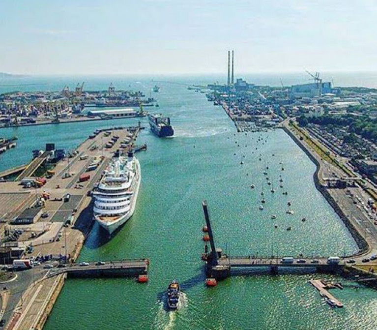
Dublin Port is Ireland’s largest and busiest port with approximately 17,000 vessel movements per year.
As well as being the country’s largest port, Dublin Port has the highest rate of growth and, in the seven years to 2019, total cargo volumes grew by 36.1%
Dublin Port Company is Hiring Marine Operatives
Dublin Port Company is currently recruiting Marine Operatives.
Dublin Port Company’s Marine Function operates a Marine Operative Pool that is a multi-skilled and multi-functional team.
The Marine Operatives, under the supervision of a Team-leader, operate with full flexibility and carry out marine-related tasks.
Marine Operatives will be expected to carry out duties in all sections of the Marine Function for which they are qualified and /or trained. Appropriate training will be provided to facilitate staff to achieve qualifications as required.
More on the role and how to apply here.
The notion of a rail and possibly road tunnel linking Northern Ireland and Scotland is once again a matter of speculation, and a Discussion Paper will be published by the British Government “within weeks”. Eleven months ago, before Brexit had been set in place and Covid-19 had really taken hold, Afloat.ie took a serious look at all the options in light of the fact that the busiest route between Ireland and Britain at the time was the Dublin-Holyhead crossing, while pressure on space in Dublin Port suggested that some out-of-the-box thinking was required. We re-publish that article of April 2020 in the knowledge that much has changed in the meantime, but the hydrographic and geographic reality remains the same.
In recent months the concept of a fixed link between Ireland and Britain has been rapidly developing as various politicians have proposed bridges between Northern Ireland and Scotland across the narrow, storm-tossed and tide-riven waters of the North Channel.
But while the distance between Fair Head on the northeast corner of Antrim and the Mull of Kintyre in West Scotland is barely 13 miles, as one critic has pointed out, this would be a link “from the back of beyond to the middle of nowhere”. For even when Scotland has been reached at Kintyre, any traffic would have hundreds of miles of driving before getting anywhere near the main road system, let alone the primary motorway routes.
As for a connection across the established ferry route between Larne in Northern Ireland and Stranraer in southwest Scotland, that would also bring traffic from Ireland into a relatively remote part of Scotland, with a long slow drive to the nearest part of the motorway system towards Carlisle in northwest England. That in turn then involves a long haul through the notoriously congested M6 in order to connect with other main routes into the prosperous southeast of England and on into mainland Europe.
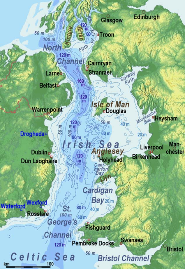 The challenges of providing a fixed link between Ireland and Britain are abundantly clear in this image, with the 160 metres depth of the explosives-filled Beaufort Dyke in the southern North Channel clearly in evidence. In terms of providing a relatively level seabed for the proposed Brunel Link from the greater Dublin area to North Wales, it looks as though a straight line between Skerries and Holyhead would offer the best option
But in any case, it has been pointed out that a Larne-Stranraer link would be considerably longer than the shorter County Antrim link between Black Head in Northern Ireland and Corsewall Point in Scotland. Yet both of these would involve difficult shoreside access, whereas a link slightly further south from Donaghadee in County Down through the nearby Copeland Island and across to Portpatrick in Scotland is only about 20 miles, although putting a motorway through the choice residential districts of North Down and across Copeland Island might meet with some local resistance.
In any case, in this area, the North Channel includes the 160 metres deep fissure which is the Beaufort Dyke, a hidden depth which has the added hazard of use as a dumping group for explosives – millions of them – after World War II ended in 1945. Even after 75 years, there is no reason to assume that they still are anything other than extremely dangerous.
Yet in theory, a viable bridge could be built at this point, for civil engineers reckon anything is possible if they’re only given enough resources to do it. Nevertheless, even though it might be less expensive than a tunnel, it boggles the mind to think of the expenditure which would be required to create a bridge structure which could withstand the really extreme conditions of the North Channel, and thus another idea which has been around for some time has been put forward as a possible solution.
 The basic structure of the Brunel Link is very simple. In the completed full-size project, a motorway standard dual carriageway with three lanes either side will be in place across the middle, while a two-line railway will run along the floor.
This is the Bridge/Tunnel, the “Brunnel”, which is somewhere between a bridge and a tunnel. It is in effect a giant tube which is laid along the sea-bed in such a way that it flexibly follows the contours when they are reasonably even, but by its nature, the structure can be reinforced to become a rigid tube-bridge when it is necessary to cross an undersea valley.
As the portmanteau name of Brunnel is so near to the surname of Brunel to remind us of the great Victorian engineer-builder Isambard Kingdom Brunel (who would be just the man for a massive and visionary project of this nature), the concept is becoming known as the Brunel Link. And its potential for being extruded in virtually infinite lengths by a giant (and we really mean giant) tube-making machine from a reinforced mixture of concrete and advance epoxies has been taken into consideration by a mysterious Dublin-based organisation known as the Committee for the Re-Alignment of Ports.
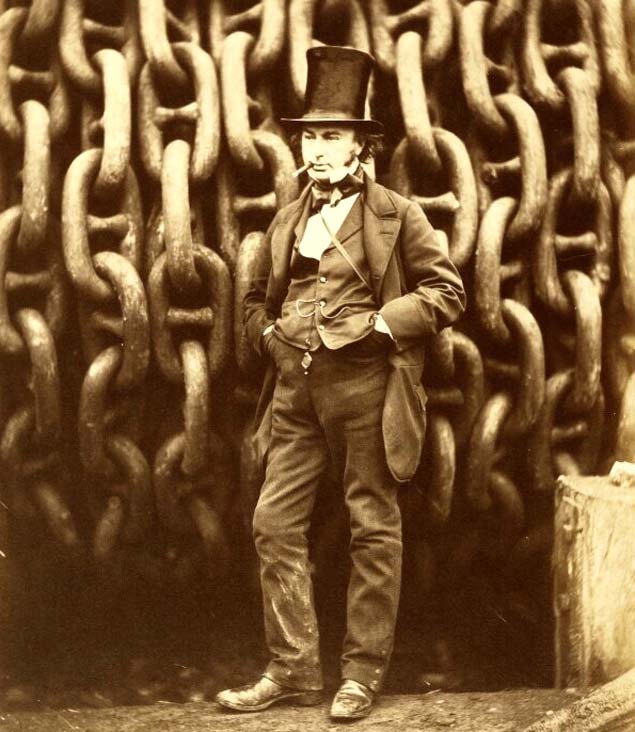 The greatest engineer? Isambard Kingdom Brunel (1806-1859) has been deservedly honoured in the name of the Brunel Link.
Basically, this Committee is primarily concerned with connecting Ireland as directly as possible with the most prosperous and industrious part of middle and southeast England, which in turn gives connections into the commercial, financial and industrial heartlands of Europe. In order to achieve this, they have concluded that the key arterial route to be followed would be based around the Dublin to Holyhead route.
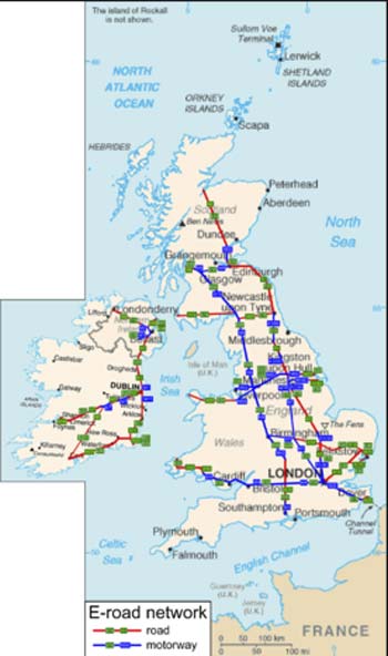 The logic of the Dublin-Holyhead link as the most efficient inter-connector from the island of Ireland to Britain’s industrial and commercial heartlands and on into mainland Europe is evident from this map of the main routes
Thus the Committee’s plan is for a Brunel cross-channel tube connection from somewhere on the coast of the Greater Dublin region to Holyhead, the structure to be of sufficient diameter to accommodate a dual carriageway motorway with three lanes either side, plus vitally important hard shoulders, at its widest horizontal diameter, and below this would be a twin-track railway system running along the Brunel Link floor which will somehow accommodate the differing railway gauges to be found on either side of the Irish Sea.
As the impetus for this huge project is essentially coming from the Irish side, the group behind it plan to invest heavily in Holyhead harbourside property. In fact, one development of this idea is that Ireland should buy Holy Island, the offlyer beside Anglesey on which Holyhead is located, and make it in effect an extension of the Irish Republic. Ideally, in fact, the promoters would like to take over the entire island of Anglesey to provide Dublin with the potential for an easterly extension and its useful hinterland.
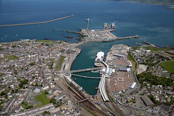 With the Brunel Link in place, the port of Holyhead could have a brighter future as an extension of Dublin Port.
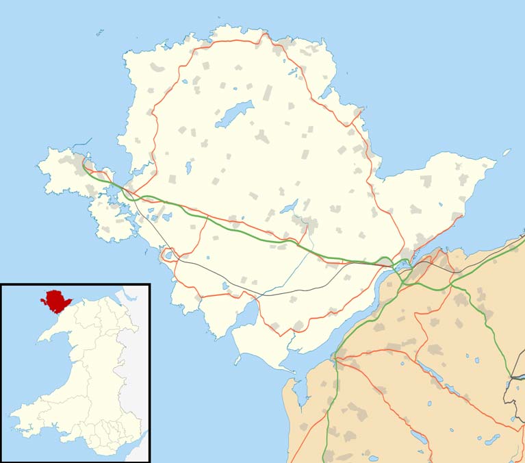 The promoters of the Brunel Link are thinking in terms of initially taking over Holy Island on which Holyhead is located, and ideally, they hope to buy all of Anglesey in due course to provide Dublin with a viable eastern hinterland.
At the moment that is only the stuff of dreams, but with the Brunel cross-channel connection, the entire geography of the northern area of St George’s Channel would be changed. With Anglesey less than an hour’s drive away from Dublin regardless of the weather, Holyhead could be transformed from an economic blackspot into becoming part of one of Europe’s most successful technical and financial hubs.
This ready access to Holyhead would, in turn, add another option to the regularly-issued demand by high-flown economic commentators and urban planners that Dublin Port be moved entirely out of the city in order to facilitate the “proper 21st Century potential” of the Capital. Those of us who think that the regular and much-observed ship movements in and out of the Port and Dublin Bay are integral to the character of the city may disagree with this, but nevertheless, it’s interesting to see how the Holyhead option may affect the overall thinking.
For the “Move the Port out of the City” movement assumes that somewhere else can be conveniently found to place the large and complex infrastructure of Dublin port. Yet no remotely comparable natural harbour exists any nearer than Carlingford Lough to the north, and Wexford Harbour to the south, while the proposals for a new port at Bremor close north of Balbriggan seem to take no account of the need there would be for the construction of massive new breakwaters to create an artificial harbour which would have to be many times the size of Dun Laoghaire.
Yet with Holyhead brought into the equation through the Brunel Link, valuable land on the East Coast of Ireland could be retained for residential and recreational use, while an under-utilised industrial area and harbour on the Welsh coast could be brought to life as an extension of Dublin port.
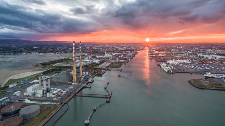 Sunset for Dublin Port? With ferry operations removed by the opening of the Brunel Link to Holyhead, and with Holyhead thereby enabled to take over the freight services of Dublin, the way would be clear for the Dublin port area to be re-developed for residential, office and recreational use.
Behind all this re-alignment of ports, the new arterial connection from the heart of Ireland through Britain to the heart of Europe would be made even more viable in several obvious ways. With the rapidly increased use of electrically-powered vehicles in the near future, the convenience and environmental compatibility of the Brunel Link, and the inescapable logic of its location, arguably make the visionary proposals from the Committee for the Re-Alignment of Ports a real no-brainer.
Dublin Port's Future Lines of Development Affect Us All
Dublin and its Port. The City and the Sea. The Culture and the Commerce. The Buzz and the Business. The sense of real working and creative life, with the romance of the ocean and the hint of salty far horizons, vibrantly cheek by jowl with a thriving yet cosy civic core in a strong dynamic that inspires art and literature while providing a special enjoyment of life.
That's Dublin. There really is nowhere else quite like it. And therein lies the problem. For although CEO Eamonn O'Reilly and his team running Ireland's largest and expanding port have direct links with comparable city ports elsewhere, and have closely studied the solutions provided by those of broadly similar size such as Helsinki, the fact is that the unique nature of Dublin's relationship with its relatively small but optimised river flowing into the elegant bay framed with beautiful hills and mountains…..well, it means that Dublin has to find its own solutions.
The importance of this is indicated by the fact that its future is a matter of serious public debate, with plans being published and up-dated with continuous re-planning being a part of the process - as it should be in a constantly-changing situation.
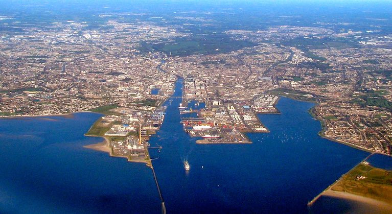
 Unusually among capital cities, Dublin continues to retain its port in the heart of the city, and it is very much part of the city's unique character
 Working port and serene seaside suburbs – looking north across Dublin Port across the Tolka Estuary to Clontarf
Thus around the turn of the Millennium, the notion of moving the basic operations of the port elsewhere came top of the agenda, and many of us were in favour of this, or a partial version of it. But when the Port Tunnel opened in 2006 as a hugely successful traffic pressure relief valve, we found ourselves – or at least I did – coming round to the idea that having an active, purposeful and comprehensive yet historic port in the heart of the city was central to Dublin's character, such that with the Port Tunnel in place, it was now surely everyone's duty to make better use of the fine facilities which had developed over the centuries as the city was reclaimed eastward.
 Before the Port Tunnel was opened in 2006, schemes for the re-location of Dublin Port abounded, and this was the proposal by one now-defunct political party for high-rise development on the Poolbeg Peninsula. The beloved "Poolbeg Stacks" are just about visible in the midst of it all, but today this imagined setup would probably be seen as a perfect Pandemic Incubation Complex
That what they used to call it: "Reclaim". It was as though the nefarious sea had spent thousands of years furtively pinching bits of the gallant Irish nation's sacred territory, and it was our patriotic duty to get it back by glorified dumping. These days in a more ecologically-aware era, it's more often called "infill". But either way, it is now deployed sparingly, even if the port and many choice parts of the city beside it are firmly located on what used to be sea and beach and muddy foreshore, so much so that when the first grand houses were built on the south and west sides of Merrion Square, they were marketed as giving proximity to the sea, and providing the finest nautical views.
The fact that the sea and ships are still but a couple of streets away has been recognized as central to Dublin's character by town-planners such as Patrick Abercrombie in 1916. That year, certain other events were taking place around the GPO, so his plans weren't published until 1922. With them, he argued that, given a choice, most people in a coastal city such as Dublin would prefer to live near the sea. And he claimed to have made this newly possible for thousands in his plans by indicating further extensive land reclamation in the Tolka Estuary to the north of the Liffey, and what we might call Irishtown Bay to the south of the Poolbeg Peninsula, and then going on to turn both new areas into attractive coastal garden towns – Welwyn-Garden-City-on-Sea with an Irish flavour, as you might say.
Now I may be missing something here, what with pandemic brain fog and so on. But it seems to me that if you turn the Tolka Estuary and Irishtown Bay into garden suburbs, then it means that, at a stroke, thousands of people who were formerly living in breezy coastal districts like Marino, south Clontarf, Irishtown and Sandymount will suddenly find that they no longer live beside the seaside, much and all as they may have liked it in the old days, when their daily inhalation of sea air and an awareness of ships coming and going into Dublin port was so much a part of life, with the Tolka Estuary and Irishtown Bay essential lungs of the community.
 The Abercrombie Plan – it was claimed that it would give thousands of people new access to coastal living. But by completely in-filling the Tolka Estuary and Irishtown, it would actually have cut off thousands of long-established residents from their cherished coastal living…..
Going back into history, it was undoubtedly necessary at one stage to build the port city eastwards towards the sea, as the mediaeval Dubh Linn – the Black Pool – up by Dublin Castle could only accommodate ships which soon seemed small by comparison with the next generation of sailing vessels, which in turn seem tiny to us now.
And unlike ports in the Baltic and the Mediterranean, Dublin had to accommodate a tidal range which was not large enough to justify locks in the dock entrances, but was quite enough to be a key factor in any harbour planning and construction costs. The story of how, over the centuries, the limited power of the ebb in the modestly-sized River Liffey was harnessed through training walls to create and maintain a deepwater channel, and a navigable passage through a bar which at one time could be forded on foot at extreme low water spring tides, is part of the romance of the story of Dublin port.
 As the port has gradually moved downriver, its nautical character has been retained with the 19th-century sailing ship Jeannie Johnson berthed in the Liffey beside new office developments
But as we've been indicating in various articles in Afloat.ie over the years, and most recently mentioned in our report of a feature on RTE's Nationwide, Dublin Port is approaching optimal expansion with planning approval granted for the final eastward development – MP-2 (Masterplan 2).
The permission sought was for fifteen years, as changing circumstances will inevitably alter requirements and project timescales. But ultimately Dublin Port's thinking is that by 2040 they'll be working to full capacity, and thus by 2030 a basic strategic plan should be in place as to how ship berthing and cargo handling facilities and logistics can best be handled along the East Coast of Ireland.
 Topped up – the most easterly proposed development indicated in the MP2 plan. Based on pre-pandemic trends, these final berths may see Dublin Port reaching full capacity by 2040
For although the West Coast is blessed with the naturally-advantaged Shannon Estuary, while the South Coast is in a league of it own with the wonder which is Cork Harbour, on the East Coast even the most sheltered big-ship-accommodating inlet – Belfast Lough – has needed very extensive dredging and harbour construction works to create the Port of Belfast, while the very existence of Dublin as a big-ship port has been as the result of ingenuity and a certain amount of good fortune over the years.
How this all came about, and where it might be going, has been collated in seven fascinating discussion papers which Dublin Port published at intervals through the latter half of 2020. However, what with the pandemic and the developing technical problems of the reality of Brexit, these papers haven't yet properly engendered the public conversation that they merit. But now they're out as a compiled pdf, which you can access by scrolling to the end of this piece.
You'll find that this is a comprehensive, informative, fascinating and at times entertaining collection which, if nothing else, makes for perfect pandemic reading. And it makes you realize that the people running Dublin Port, led by Eamonn O'Reilly and inspired by Heritage Director Lar Joye, have a profound insight into the deeper meaning of the symbiotic relationship of the city and its harbour.
 Eamonn O'Reilly, CEO of Dublin Port. Photo: RTE/Screenshot
 Lar Joye, Heritage Director of Dublin Port. Photo: RTE/Screenshot
But before we go into a summary of what it all might mean, here's a snippet of information which recently emerged from Rome on December 5th 2020. While we may have suggested that Dublin's situation is so unique that the city has largely had to find its own way through solving its port conundrum, nevertheless we might make an exception for port news from the Eternal City. For it seems that no sooner had an initial €300 million been allocated to parts of Italy from the EU Recovery Fund than the Mayor of Rome, Virginia Raggi, staked a claim for it to be used to restore the River Tiber to a navigable state which would permit ships to be berthed once more in the heart of the city.
For, like many cities, Rome has long since seen its commercial port located further and further from the heart of town. But the creation of a commerce-free waterway through town contributes to the city it used to serve becoming something of an empty husk of a place, a sort of Disneyland of a city. If Disneyland is your thing, then that's fine and dandy. But many who live and work in Dublin are quietly happy that their slightly eccentric hometown is a living breathing seaport rather than a glorified film set.
 The River Tiber in Rome is of a size comparable to the Liffey in Dublin. Rome's seaport is now far from the city, but the Mayor wants to bring ships back to town.
But a living breathing seaport has to be a viable commercial and logistical operation. So if we're facing a scenario where Dublin Port is approaching saturation by 2040, what's the plan?
Admittedly in these hyper-volatile times, such predictions of saturation may be changing by the day, what with changes in the way we live and work, changing in manufacturing techniques, and changes in travel and transport patterns. So really there's no plan, just ongoing planning, for we can only follow the mighty economist John Maynard Keynes who - when accused in a personal attack of changing his mind in a big way – riposted with vigour: "When circumstances change, I change my mind. What do you do?"
So by the time we can hope to get a clearer picture of where the world has got to in the coming Autumn, it may well be that those developers who would wish to take over swathes of dockland to build high-rise offices and apartments will find that the need for offices has shrunk, while potential flat-dwellers will have come to see dense apartment blocks as perfect pandemic incubation units, with that Irish desire for a bit of green space – however tiny – setting the property agenda.
And yes, I do know that recently the Dublin City senior planner has announced that the days of the three-bed semi-detached house "are over" and the future is in apartments, but presumably he somehow enjoyed lockdown and WFH in an apartment while the rest of us were sustained largely by the proximity of our little gardens.
As for Dublin Port reaching saturation, it's equally likely that by 2040, the shipping and stevedoring industry will have devised more efficient ways of using the facilities available, while the greater integration of the port with the city by means of safe cycle-ways, protected walking trails, and accessible user-friendly public spaces will have enhanced the sense of Dublin Port being an attraction to be cherished, rather than a totally utilitarian necessity which is best shunted off elsewhere.
Nevertheless Dublin Port have outlined other options in their discussion papers, and the real meat on that comes in Papers 5,6 and 7, where they address the possibility of additional or alternative facilities through DP2.0 at Bremore on the northern tip of Fingal which - under some pieces of legislation - is still seen as being in County Dublin, or else at Arklow in County Wicklow.
 Dublin Port's outline of the scale and quality of design which would be required in a completely new harbour at Bremore in Fingal
 Building a proper port at Bremore would be a complex and very expensive project
It's a sobering document for those who blithely talk of building completely new big-ship harbours on what is an exposed east-facing coastline. Anyone who thinks that Ireland's east coast is snugly sheltered from the prevailing westerly winds would do well to remember that wind patterns have changed somewhat, and Storm Emma in March 2018 – the Beast from the East – very forcefully indicated the kind of conditions that a 24/7 port at Bremore or Arklow would have to be capable of withstanding.
 Dublin Port's outline proposals of the harbour requirements which would be needed at Arklow
 As at Bremore, a new port at Arklow would require extensive shoreside development in addition to massive breakwaters
But in the spirit of the brief for their Discussion Papers, Dublin Port has done thorough research and conceptual design work on these possible developments. Even the most basic breakwater construction works on such facilities will not come cheap, and at mid-2020 costings (which will have already risen) Arklow comes in at €3.9 billion, while Bremor would be higher again, at €4.2 billion.
With the costs of associated shoreside infrastructure still to come, those figures are only by way of a deposit, while beyond all that there's the environmental impact, increasingly a matter of public concern, and very valid in these cases.
A telling paragraph in Paper 6 puts it in perspective:
"Because Dublin Port is nestled into Dublin Bay and along the banks of the Liffey, it can be difficult to appreciate its scale. For example, the distance from the Tom Clarke Bridge to the end of the easternmost berth in Dublin Port is almost three kilometres. It is a further two kilometres from this point to the entrance to the port at the Poolbeg Lighthouse. Dublin Port is concave; DP2.0 would be convex. DP2.0 would extend 3.2 kilometres into the Irish Sea if built at Arklow, and 4.5 kilometres if constructed at Bremore."
As it happens, the main factor in the nation's economy for the foreseeable future is surely going to be handling the debt incurred from the various pandemic shutdowns. So although some major infrastructural projects might well be promoted as integral to economic vitality and revival, schemes like these totally new harbours – described by planners and engineers as being in the realms of "megaprojects"- are of doubtful real benefit if more effective use of existing facilities can solve the problem and thus leave the necessary funding available for much-needed housing.
Meanwhile, the management and specialists at Dublin Port have given us plenty of material for discussion, and their analyses and conclusions merit serious attention with thoughtful answers rather some headline-grabbing flippant responses.
We'll allow Eamonn O'Reilly and his team the last word:
"Our analysis of these issues in the seven papers of the Dublin Port Post 2040 Dialogue leads to the following conclusions:
Conclusion 1
Dublin Port Company must complete all of the projects outlined in Masterplan 2040 to deliver infrastructure with an annual throughput capacity of 77 million gross tonnes by 2040.
Conclusion 2
Critically, this will require planning permission to be secured for the 3FM Project.
Conclusion 3
The achievement of a throughput of 77 million gross tonnes per annum by 2040 will require not only the completion of all of the infrastructure projects in Masterplan 2040; it will also require that the efficiency of port operations greatly increases so that port infrastructure is utilised to its maximum. This will require the elimination of systemic inefficiencies in existing supply chain operations.
Conclusion 4
Over the next 20 years, additional capacity at other existing east coast ports will be required so that, as Dublin Port approaches its ultimate capacity, volumes which Dublin cannot handle can be accommodated elsewhere.
Conclusion 5
During these 20 years, DPC will need to work on the DP1.5 project so that it can be brought through the planning process and construction started by about 2033 should that become necessary.
Conclusion 6
The projects to provide additional capacity in other ports and the project to construct DP1.5 can only be realised with State support – none of the projects and none of the port companies (including DPC) are capable of raising the project finance that would be required.
These six conclusions will inform DPC's contribution during 2021, firstly, to the preparation of the next Dublin City Development Plan and, secondly, to Government's review of the National Development Plan.
In publishing the seven papers, we have invited others to critique our thinking and to prepare detailed responses including, possibly, alternative analysis which yields different conclusions to ours. The long-term planning challenges faced by DPC are national challenges and it is important that future port capacity plans are formulated on the basis of as detailed a consideration of the issues as is possible."
Download the 'Dublin Port Post 2040 Dialogue' below
Dublin Port Welcomes Samskip’s First Direct Container Sailing Between Amsterdam & Ireland
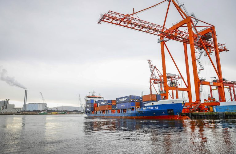
Dublin Port today welcomed Samskip’s first direct container sailing between Amsterdam and Ireland, with RMS Veritas arriving into Dublin Port at lunchtime, marking the start of a new weekly shortsea container freight service between Dublin and North Continental Europe, while increasing options for importers and exporters post-Brexit.
Dublin Port's 2040 Plan Airs on RTE's Nationwide
Dublin Port Chief Executive Eamonn O'Reilly told RTE One's Nationwide programme this week that the capital's port will reach capacity in 2040.
The CEO said the port, that handles almost 50% of all trade in the Republic of Ireland, faces a huge challenge to build infrastructure to cope with the growth in cargo on the River Liffey over the next 20 years.
As Afloat previously reported details of the port's plan for its future are contained in its masterplan.
O'Reilly's interview featured in RTE One's Nationwide programme on Wednesday evening and can be reviewed on the RTE Player here (scroll to 11.45 on the timeline).
O'Reilly said these were 'extraordinary times' in the history of the port. By 2040, the port will have reached its maximum capacity, some 333 years since the first port authority in Dublin was established.
Dublin Port Heritage zone
O'Reilly also said the port wasn't just focussed on building port infrastructure but is also preparing to open the port to the public.
"We cannot just have the port as an industrial zone and ignore the local community".
As a result, a two-acre site within the port is being transformed into a heritage zone so Dubliners can come down to the Port area and enjoy the experience of having a living working port in the heart of their city.
The Port is also constructing a greenway on the north side at the River Tolka estuary where a four km cycle lane will be provided for leisure purposes.
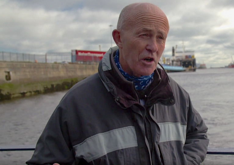
Elsewhere in the programme, Dublin Port Heritage Director Lar Joye gives a guided tour of port operations as part of the recent Open House architecture festival.
 Lar Joye, Dublin Port Heritage Director Screenshot: Nationwide
The tour takes in a trip around Alexandra Basin and Joye observes the MV Shingle, a ship seized in 2014 over €14m worth of tobacco that still awaits its breakup and the Kittiwake, an old lightship that is going be restored as part of the new heritage zone.
Joye's interview can be reviewed on the RTE Player here (scroll to 2.14 on the timeline).
Dublin Port Issues 2021 Notice to Mariners, Including 'Dublin Bay Guidance Notes for Leisure Craft'
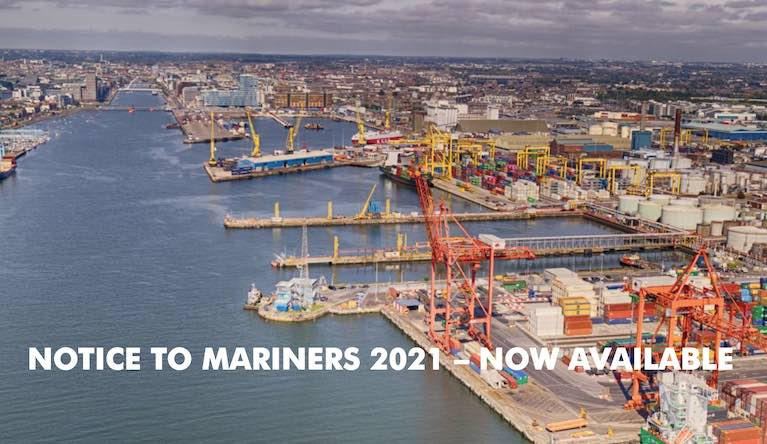
Dublin Port Company has issued its 2021 Notices to Mariners.
The well-presented page on the Dublin Port website here provides links to over 40 different notices covering all aspects of Dublin Port activity in 2021 at Ireland's busiest port in a bay that contains Ireland's biggest boating population of approximately 1,000 boats at nearby Dun Laoghaire Harbour.
All 2020 Notices to Mariners not previously cancelled were automatically cancelled at 23:59 hours on the 31 December 2020.
Guidance Notes for Leisure Craft
Of particular note to recreational boaters is No.19 of 2021, which sets out guidelines for all leisure craft as set out in the “Dublin Bay Guidance Notes for Leisure Craft” here.
The notice states that when navigating within the approaches to Dublin Port and in the vicinity of the Fairway Channel, it is a requirement that persons in charge of leisure craft must maintain a watch on VHF Channel 12. They should ensure that they keep themselves fully aware of all shipping movements and operations.
 DBSC's New Ross buoy is a yacht racing mark on Dublin Bay Photo: Afloat
DBSC Marks on Dublin Bay
Notice number 15 deals with yacht racing marks in the Bay and outlines Dublin Bay Sailing Club 'statutory sanction' to lay the following yacht racing marks within the Dublin Port Limits from April to October.
Dublin Bay Terns
In Notice number 29, all leisure craft are to navigate with due care and attention when in the vicinity of a pontoon located in a position south of the buoyed channel on the River Liffey as it is a nesting site for birds. The 17m x 8m pontoon is moored and lit on both the eastern and western ends with yellow lights. To avoid disturbing the nesting birds, it is forbidden to moor to or go alongside the pontoon.
The 2021 Notices to Mariners page on the Dublin Port website is here


 LÉ Aoibhinn and LÉ Gobnait at the Naval Service Base at Haulbowline, Cork Harbour. They are to carry out fishery duties, etc on the Irish Sea, east and south-east.")


