


Displaying items by tag: RV Celtic Voyager
Marine Institute Welcomes Irish Commitments To Ocean Research

The Marine Institute has welcomed Irish commitments announced at the recent Our Ocean Conference in Bali which include the provision of €25 million for a 50-metre modern research vessel to replace the RV Celtic Voyager.
“The vessel will provide critical national infrastructure to enable Ireland to address the considerable challenges of Brexit and the Common Fisheries Policy as well as climate-induced impacts on our oceans,” Marine Institute chief executive Dr Peter Heffernan said.
In addition, the Marine Institute says it has committed €2 million towards a new five-year programme of ocean and climate research.
With 50% funding from the EU ERDF scheme, the Marine Institute is running a competitive funding call to support the establishment of a principal investigator-led research team in an Irish higher education iSnstitution.
“This is a key investment to build capacity in an area of research prioritised under the National Marine Research and Innovation Strategy (2017-2021),” Dr Heffernan said.
“The research funded under this programme will deliver societally relevant knowledge aimed at better understanding the complex interactions between the ocean and climate change.”
Minister Creed also announced the continued commitment to the Environmental Educational module of Ireland’s Green Schools programme, and the continued support of the Clean Coasts programme.
“These programmes aim to build on Ireland’s marine and maritime heritage by increasing awareness of the value, opportunities and social benefits of our ocean wealth and identity, further supporting the Marine Institute’s Explorers Education Programme,” Dr Heffernan said.
Other announcements by Ireland include the provision of €10m to the local authority sector in Ireland to aid in the establishment of four Climate Action Regional Offices (CAROs) and €1m over a five-year period (2019-2024) towards a new programme of ocean and climate research.
The Marine Institute also welcomes commitments announced by the European Commission which include €300 million for EU-funded initiatives for projects to tackle plastic pollution, make the ‘blue economy’ more sustainable and improve research and marine surveillance.
‘Operation Orca’ Set To Survey Scottish Killer Whales On Celtic Voyager

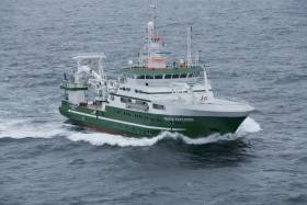
#MarineWildlife - The RV Celtic Voyager departed the Port of Cork yesterday (Wednesday 24 October) for ‘Operation Orca’, a 12-day survey of an offshore killer whale community associated with the Northeast Atlantic mackerel fishery.
A team of marine scientists from University College Cork is on board the research vessel that’s headed to waters east of the Orkneys, to study the orcas that feed on mackerel between October and February each year.
“This is the first time a dedicated research vessel will be heading up to study these killer whales and we are hopeful to come back with a lot of data,” said PhD researcher and chief scientist Róisín Pinfield in her introductory blog for the survey.
“We will have cameras, GoPros, drones, underwater hydrophones collecting acoustic data so we can hear the killer whales and a RIB so we can get in close if weather conditions allow. Time to pray to the weather gods to keep the storms away!”
The Scientists@Sea blog will be regularly updated by the Celtic Voyager team once they reach the fishing grounds and begin their survey, which runs till Sunday 4 November.
Shiptime Charter Applications For 2019 & 2020 Now Open

#MarineScience - Applications are open for shiptime in 2019 and 2020 on Ireland’s national research vessels Celtic Explorer and Celtic Voyager, as well as the ROV Holland I and the Laochra na Mara glider.
Every year a broad range of organisations use the Marine Institute’s vessels for research, development and monitoring programmes. These include Government departments and agencies, universities, research institutes and industry.
Applications for shiptime for 2019 and 2020 must be submitted using Research Vessel Operations’ online Survey Planning System (SPS) by Thursday 20 September. Please contact Research Vessel Operations to obtain an SPS login if you don’t already have one and to inquire about glider availability.
Each application will be reviewed and the applicant will be informed as soon as possible whether the shiptime they requested is available. If the requested shiptime is not available, alternative dates may be offered. The Vessel Charter Guidelines should be read carefully before submitting the ship time application form.
Applicants may seek grant aid to cover all or part of the vessel charter costs for research surveys or ship-based Training Programmes. The closing date for receipt of grant aid applications is 5pm on Friday 21 September.
Applicants for ship-based training are advised to consult with the Strategic Marine Alliance for Research and Training (SMART) at [email protected].
The survey schedules can change during the year, therefore please contact Research Vessel Operations to check whether any survey slots remain for 2018 or to be notified if any dates become available.

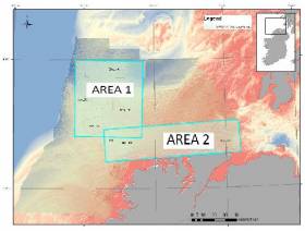
#MarineScience - Researchers at NUI Galway, along with partners at the Irish Centre for Research in Applied Geosciences (iCRAG) and the Marine Institute, are currently carrying out a marine hydroacoustic survey in the eastern margin of the Porcupine Basin.
Continuing till this Saturday 16 June, the project conducted from the RV Celtic Voyager (Callsign EIQN) involves generating an acoustic sound source (seismic airgun) adjacent to a short-term deployment of a hydrophone mooring and drifter array in order to investigate noise propagation across the Irish continental margin. The project is planned to inform research into noise pollution as part of Ireland’s obligations under the Marine Strategy Framework Directive (MSFD).
Approximate locations of fixed moorings and seismic noise transect are included in Marine Notice No 24 of 2018, a PDF of which is available to read or download HERE.
Fixed moorings will include yellow surface buoys with warning lights: high intensity, quick flash, continuous, yellow. The drifter will include a yellow surface buoy with nav light: 5 flashes every 20 seconds, yellow, 2nm distance.
The RV Celtic Voyager is displaying appropriate lights and signals and will be within the vicinity at all times throughout the survey.
Researchers also emphasise that the closest distance from survey to any marine SAC is over 16 nautical miles. Commercial fishing and other marine operators are requested to keep a 3nm distance from any survey instrument moorings, and to keep a 2nm distance around the entire survey area clear of any gear or apparatus during the survey period outlined above.
Geophysical Research Survey Off North West Coast In May
#MarineNotice - Maynooth University will carry out a geophysical research survey off the North West Coast of Ireland from next weekend.
Work is expected to commence on Sunday 6 May and last for approximately nine days, subject to weather conditions.
The Marine Institute’s research vessel RV Celtic Voyager (Callsign EIQN) is scheduled to carry out the works for the Mara survey, undertaken by researchers in Maynooth University to collect geophysical acoustic survey data as well as sediment grab and core samples.
The survey will use relatively low amplitude sound sources to image into the seabed including an echosounder and a sparker system, which will allow for the characterisation of seabed type to inform the deglacial dynamics of the climatically driven British Irish Ice Sheet.
The vessel will, on occasion, be towing a hydrophone cable and other equipment, up to a maximum of 50 metres behind the vessel. The vessel will be restricted in its movements when towing a cable astern.
All other vessels are requested to give the operation a wide berth. The vessel will be listening on VHF Channel 16 throughout the project.
Details of the survey area, relevant co-ordinates and contact information are included in Marine Notice No 19 of 2018, a PDF of which is available to read or download HERE.
#MarineNotice - Hydrographic and geophysical surveys will be undertaken in the Celtic Sea and Atlantic Ocean under the INFOMAR (Integrated Mapping for the Sustainable Development of Ireland’s Marine Resources) programme until October 2018.
Geological Survey Ireland vessels the RV Keary (Callsign EI-GO-9), RV Geo (Callsign EI-DK-6), RV Tonn (Callsign EI-PT-7), RV Mallet (Callsign EI-SN-9) and RV Lir (Callsign EI-HI-2) are already involved in scheduled surveys since March.
Marine Institute vessels the RV Celtic Explorer (Callsign EIGB) and RV Celtic Voyager (Callsign EIQN) will begin surveys this weekend, starting with the former vessel on a three-week survey from Sunday 22 April.
The Celtic Voyager and the Celtic Explorer will be towing a magnetometer sensor with a single cable of up to 200 metres in length. The vessels will display appropriate lights and markers, and will be listening on VHF Channel 16 throughout the course of the surveys.
Details of co-ordinates for these surveys are included in Marine Notice No 18 of 2018, a PDF of which is available to read or download HERE.
Note that the Atlantic Ocean Area may not be surveyed in 2018, but if for operational reasons the survey does take place, it will be during the dates set out above for the Celtic Voyager surveys listed therein. In that event, the Marine Notice will be updated with specific dates.
#MarineScience - A new survey sampling Nephrops larvae from the area west of the Aran Islands is currently being conducted for the first time aboard the RV Celtic Voyager.
“Nephrops are more commonly known as Dublin Bay prawn, Norway lobster or scampi, and are the most valuable demersal fishery in Ireland,” said Ryan McGeady, PhD candidate at NUI Galway and chief scientist on the two-week mission which began on Tuesday 3 April.
“The value of Nephrops of landings by Irish vessels was €60 million, the stocks around Ireland that the Marine Institute assess with the underwater TV surveys is more than €100 million.”
Nephrops are widely distributed in Irish waters, found in the Irish Sea, the Celtic Sea and off the West Coast of Ireland. They spend a great deal of time in their burrows found in areas of muddy sediment at the bottom of the ocean only coming out for food or mating purposes.
Unlike fish, Nephrops cannot be aged directly. Coupled with their complex biology and behaviour, stock assessment of Nephrops is notoriously difficult to assess.
Since 2002, the Marine Institute has been using underwater television surveys to independently estimate abundance, distribution and stock sizes on the Aran Grounds, Western Irish Sea and the Celtic Sea.
However, the primary focus of this survey is to collect data on the distribution of Nephrops larvae from two commercially important grounds, including off the West Coast and the Irish Sea.
Female Nephrops mature at three years of age, when they start to reproduce each year. After mating in early summer, they spawn in September, and carry eggs under their tails until they hatch in April or May. The Nephrops larvae develop in the plankton before settling to the seabed nearly two months later.
“The importance of this survey is that it is multi-disciplinary which allows us to use both oceanographic data and biological sampling to increase our knowledge on what influences larval distribution and retention on mud patches where the species lives,” Dr Colm Lordan of the Marine Institute said.
The data collected will be used to improve the accuracy of computer models that simulate the movement of Nephrop larvae in the ocean. The information gathered during the survey will also be used to validate or ‘ground-truth’ the model to ensure its accuracy.
“It is hoped that an improved model can be used to estimate the proportion of larvae surviving to adulthood each year. This will make it easier to estimate the health of the stock,” said Dr Anne Marie Power of NUI Galway.
Acoustic records of pelagic fish shoals will also be collected to compare with characteristics of the environment. Observations will be carried out to examine the effect of trawling on fish aggregations once gear has passed through.
Fish shoal sampling will contribute towards an IRC-funded project that will use models of mackerel collective behaviour to improve traditional fisheries assessments and provide a framework for using shoals as an indicator of population health.
Oceanographic data collection will feature hyper-spectral light measurements to assist in the validation efforts of Irish satellites. This will support a Marine Institute Cullen Fellow examining space-based observations of marine phytoplankton in Northeast Atlantic surface water masses and potential environmental monitoring applications.
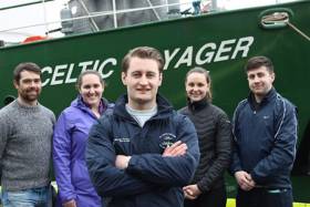
The team of scientists supporting Cullen Fellow Ryan McGeady board the RV Celtic Voyager includes Darragh Furey (Galway); Sophia Wasserman (Maryland, USA; IRC postgraduate scholar); Catherine Jordan (Mayo; Marine Institute Cullen Fellow/ NUIGalway); and Leigh Barnwall (Dublin). Dr Anne Marie Power Dr Colm Lordan are providing base support for this research.
This research survey is carried out with the support of the Marine Institute, funded under the Marine Research Programme 2014-2020 by the Irish Government.
Celtic Voyager Explores Irish Sea’s Lost landscapes

#MarineScience - An Irish research team from IT Sligo and University College Cork recently joined the ‘Europe’s Lost Frontiers’ project to explore the extensive submerged landscapes in the Irish Sea aboard the Marine Institute’s Celtic Voyager research vessel research vessel.
Following the last Ice Age, large areas of habitable land were inundated following climate change and sea level rise across the world. Globally, the sea level rose around 120 metres and an area more than twice that of the modern United States of America was lost to the sea.
Beneath the waves of the Irish Sea is a prehistoric ‘palaeolandscape’ of plains, hills, marshlands and river valleys in which evidence of human activity is expected to be preserved.
This landscape is similar to Doggerland, an area of the southern North Sea and currently the best known example of a palaeolandscape in Europe. Doggerland has been extensively researched by Prof Vince Gaffney, principal investigator of the Europe’s Lost Frontiers project.
“Research by the project team has also provided accurate maps for the submerged lands that lie between Ireland and Britain,” said Prof Gaffney, “and these are suspected to hold crucial information regarding the first settlers of Ireland and adjacent lands along the Atlantic corridor.”
To provide this evidence, sediment from some 60 cores, taken from 20 sites by the RV Celtic Voyager in Liverpool and Cardigan Bays between the 21 and 25 February, will be studied by an international marine research team.
Dr James Bonsall, from the Centre for Environmental Research Innovation and Sustainability (CERIS) in the Department of Environmental Science at IT Sligo, was chief scientist for this phase of the research, and together with his CERIS colleague, environmental scientist Eithne Davis, directed operations on board the RV Celtic Voyager.
“It is very exciting,” said Dr Bonsall, “as we’re using cutting-edge technology to retrieve the first evidence for life within landscapes that were inundated by rising sea levels thousands of years ago.
“This is the first time that this range of techniques has been employed on submerged landscapes under the Irish Sea. Today we perceive the Irish Sea as a large body of water, a sea that separates us from Britain and mainland Europe, a sea that gives us an identity as a proud island nation. But 18,000 years ago, Ireland, Britain and Europe were part of a single landmass that gradually flooded over thousands of years, forming the islands that we know today.
“We’re going to find out where, when, why and how people lived on a landscape that today is located beneath the waves.”
Key outcomes of the research will be to reconstruct and simulate the palaeo-environments of the Irish Sea, using ancient DNA, analysed in the laboratories at the University of Warwick, and palaeo-environmental data extracted from the sediment cores.
The studies will be of immense value in understanding ‘first’ or ‘early’ contact and settlement around the coasts of Ireland and Britain, but also the lifestyles of those people who lived within the inundated, prehistoric landscapes that lie between our islands and which have never been adequately explored by archaeologists.
The Celtic Voyager and the Marine Institute’s expertise were provided to explore the extensive submerged landscapes, where marine core samples were taken. Technical support setting up the seabed survey and navigation systems was also provided by members of the DCCAE-funded INFOMAR team, who specialise in bathymetric mapping and geophysical survey.
This research survey was carried out with the support of the Marine Institute, funded under the Marine Research Programme 2014-2020 by the Irish Government.
Europe’s Lost Frontiers is an ERC-funded Advanced Grant project based at the University of Bradford. Aimed at understanding the transition between hunter gathering to farming in north-west Europe, the project is studying the evidence for inundated palaeolandscapes around the British coast using seismic reflectance data sets to generate topographical maps of these ‘lost lands’ that are as accurate and complete as possible.
Environmental data from these areas is then being used to reconstruct and simulate the palaeo-environments of these landscapes using ancient DNA extracted directly from sediment cores as well as traditional environmental evidence.
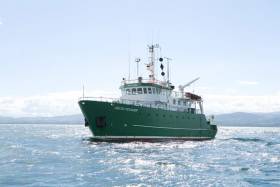
RV Celtic Voyager To Be Replaced As Part Of National Development Plan

#MarineScience - The Government’s new National Development Plan includes provision for a new marine research vessel to replace the RV Celtic Voyager, according to The Irish Times.
Marine Institute chief executive Dr Peter Heffernan says work is at an “advanced stage” towards confirmation of the project, which would see the 31-metre Celtic Voyager — which has served for two decades — replaced with a vessel of around 50 metres in length.
The new ship would serve alongside the RV Celtic Explorer, which recently underwent a major refit, as previously reported on Afloat.ie.
Open Call For Training Through Research Surveys In 2018
#MarineScience - The call for applicants to take part in Training Through Research Surveys (TTRS) is now open to graduate and postgraduate students from across Ireland.
TTRS is a collaboration between the Strategic Marine Alliance for Research & Training (SMART) and the Marine Institute, which aims to increase national capacity in offshore marine research by providing placements on a range of dedicated research surveys.
TTRS surveys give students the opportunity to develop their careers in ocean science and gain hands-on research experience on board the Marine Institute’s research vessels, RV Celtic Explorer and RV Celtic Voyager.
Students can develop the skills required to work at sea including using advanced and up-to-date equipment and instrumentation as well as collecting and handling data.
Taking part in a TTRS survey enables students to establish new professional contacts with experienced scientists and researchers, as well as make a real contribution to the survey goals.
This year’s TTRS surveys are as follows:
- Anglerfish and megrim survey: Legs 1 (19-27 February), 2 (27 February-8 March), 3 (9-19 March) and 4 (10-20 April)
- Blue whiting acoustic survey (20 March-9 April)
- INFOMAR hydrographic survey (21 April-13 May)
- Western European Shelf Pelagic Acoustic Survey (WESPAS) Legs 1 (9-18 June) and 2 (3-24 July)
- Celtic Sea herring acoustic survey (7-27 October)
To take part in a TTRS survey, visit the Smart Sea School website and complete an online application form. To read previous participants' experience of TTRS, visit the SMART blog.
Applicants for Training Through Research Surveys:
- must hold a degree in marine-related science or technology or be in the final year of their undergraduate programme.
- must hold a valid ENG11 medical certificate and a Personal Survival Techniques (PST) certificate (STCW95).
- should have some prior seagoing experience.
Please note that ENG11 medical certificates must be renewed every two years and PST certification renewed every five years.
Information on obtaining medical and sea-survival certificates, and check lists for scientists embarking on national research vessels is available from the Vessel User Information page on the Marine Institute website.
TTRS participants are responsible for costs incurred in travelling to and from survey ports. For queries please contact [email protected].
TTRS surveys are supported by the Marine Institute. Grant-aided ship time is carried out under the Strategic Marine Research & Innovation Agenda of the Integrated Marine Plan for Ireland (Harnessing Our Ocean Wealth) under the Marine Research sub-programme of the Irish Government.
Participation in surveys is by kind agreement with the survey chief scientist. Applications are invited from graduate and postgraduate students of Ireland of Ireland higher education institutions.


 located at Ringsend on the south bank of Dublin Port. AFLOAT also add the Group over the last decade has invested over €30 million across MTL’s infrastructure and the terminal has a throughput of 250,000 TEU’s per year, with direct LoLo connections with ports in Central Europe and Irish Sea as well as feeder services connecting us with the Far East, India and South America.")

 linking Spain.")


 Michael Murphy Schull Harbour Sailing Club (SHSC), Eric Coogan Heineken Ireland, Mark Murphy, Commodore SHSC, Jack Allen SHSC, Carmel O'Regan SHSC, Cornelious Ndlovu, Schull Harbour Hotel Operations Manager and Derval Murphy SHSC")


