


Displaying items by tag: Met Eireann
‘Too Early To Tell’ What Impact Hurricane Lorenzo Might Have On Ireland This Week
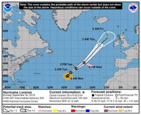
Met Éireann says the progress of Hurricane Lorenzo this week and any potential impacts for Ireland “are being closely monitored”.
The powerful weather system, which is currently threatening the Azores in the mid-Atlantic, was recently the most easterly Category 5 hurricane on record, surpassing Hurricane Hugo 30 years ago.
Forecasts beyond the next 48 hours “still of low confidence given the uncertainty” of the storm’s current behaviour.
Numerical prediction models currently show a wide spread of outcomes for the storm track ranging from Greenland to the north of France.
As of today (Monday 30 September) it’s expected that Lorenzo will transition into an “extra-tropical depression” between noon and midnight on Wednesday 2 October.
Met Éireann says its most likely path after this transition brings it to the northwest of Ireland without making landfall.
However, even at that it “still brings the risk of severe winds, possibly stormy conditions and very high seas”, as Met Éireann’s Deirdre Lowe told BreakingNews.ie.
Latest updates will be provided on the Met Éireann website HERE.
Status Red Upgrade For Co Clare As Storm Hannah Sweeps In

The weather warning issued by Met Éireann for Co Clare has been upgraded to the most severe Status Red as Storm Hannah is expect to brings gusts of up to 150km/h this evening (Friday 26 April).
Meanwhile, the marine warning has been upgraded to Status Orange, as cyclonic variable winds will increase to gale Force 8 or strong gale Force 9 on Irish coastal waters from Howth Head to Mizen Head to Rossan Point and on the south Irish Sea during this afternoon and evening.
Winds are forecast to reach storm Force 10 to violent storm Force 11 this evening and early tonight between Carnsore Point and Slyne Head.
The extreme weather has seen the cancellation of sailing and watersport events nationwide, including rowing’s Limerick Regatta which had been scheduled for tomorrow.
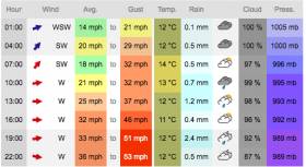
Storm Fionn Prompts Gale Warning For Irish Coasts

#StormFionn - Met Éireann has issued a Status Orange marine weather warning for all coasts of Ireland and on the Irish Sea today (Tuesday 16 January) as Storm Fionn sweeps in.
Westerly gales or strong gales with mean speeds of up to 80km/h and gusts of as much as 120km/h are forecast for all coastal waters, increasing to storm force from Roches Point to Slyne Head to Malin Head later this afternoon, this evening and tonight.
Donegal, Galway, Leitrim, Mayo, Sligo, Clare, Cork and Kerry are under a Status Orange wind warning till late tonight, with much of the rest of the country under Status Yellow for mean wind speeds of between 55 and 65km/h and gusts of around 100km/h expected.
The sixth winter storm of the current season comes two weeks after Storm Eleanor, the brunt of which was felt in Donegal and Northern Ireland.
Orange Warning For Storm Eleanor On All Irish Coasts Today

#StormEleanor - Just days after Storm Dylan swept across the north of Ireland, winter storm number five is set to move in off the Atlantic later this afternoon (Tuesday 2 January).
Met Éireann has issued a Status Orange weather warning for Munster, Leinster, South Galway and for small craft in all Irish coastal waters as the storm system moves quickly across the country this evening, with southwest to west winds of mean speeds of 65 to 80 kmh, gusting to 110 to 130 km/h.
Gale to stormforce south to southwest winds will veer westerly on all coasts of Ireland and on the Irish Sea, with a risk of violent Force 11 winds briefly on some western and eastern coasts and on parts of the North Irish Sea.
Storm Dylan’s Approach Brings Status Orange Coastal Warning

#Weather - Barely a month after Storm Caroline, a Status Orange gale warning is in effect on all Irish coastal waters and on the Irish Sea as Storm Dylan is forecast to sweep over the country this evening (Saturday 30 December).
South to southwest games or strong gales are expected to develop around the coast tonight, reaching storm force in western areas, with a Status Yellow small craft warning also in effect.
Met Éireann says the expected track of the fourth winter storm of the current season is north-eastwards through Donegal Bay and along the North Coast.
The biggest impact from the storm will be across Connacht and Ulster, where west to southwest winds will hit with mean speeds of 60 to 80 km/h with gusts of up to 120km/hr. High seas along the west coast are also expected, with the risk of coastal flooding.
The national Status Orange wind warning applies from 9pm this evening till 6am tomorrow (Sunday 31 December) in all counties of Connacht; Cavan, Monaghan and Donegal; Longford, Louth, Meath and Westmeath. A Status Yellow warning is in place for all counties in Munster, and Leinster counties Dublin, Carlow, Kildare, Kilkenny, Laois, Wexford, Wicklow and Offaly.
Gale Warning For Irish Coastal Waters Ahead Of Storm Caroline’s Passage

#Weather - Met Éireann has issued a Status Yellow gale warning on all Irish coastal waters and on the Irish Sea in effect from 5am this morning (Wednesday 6 December).
Gusts of up to 110km/h are expected along all coastal areas today ahead of Storm Caroline’s passage over the North West and North towards Scotland on Thursday.
High winds will affect parts of Scotland, but the storm system — the third of the current winter storm cycle — will also generate strong and blustery winds over Ireland.
Northwest winds of 55 to 65 are expected to gust 100 to 110 km/h, with the strongest winds in coastal areas and over high ground.
The severe weather comes almost two months after the near-hurricane Ophelia devastated many parts of Ireland.
Are Sea Area Forecasts Necessary?
In this digital age, with so many available resources providing sea area weather forecasts, is there still a need for national radio to broadcast these forecasts?
I heard an RTE Radio Presenter asking a Met Eireann meteorologist on-air whether there was any point in broadcasting weather forecasts for the marine sector any more, because there was so much detailed weather information available online.
It reminded me of the battles I had with RTE Radio managers and schedulers when they came up with their idea of ending such weather forecasts altogether, because they took up broadcast time which could better used.
I was Marine Correspondent with RTE then so the conversation a few weeks ago between the RTE Presenter and Met Eireann reawakened my memories of those internal RTE disagreements and underlined for me how badly served the maritime sector is by the national media, both broadcast and print.
It also underlines why the BBC Radio Shipping Forecasts are popular amongst Irish fishermen, mariners, professional, commercial and leisure – because it’s a specialised service to the marine sector that RTE doesn’t provide in the same way.
The coastal radio stations of the Coast Guard give weather forecasts which are available at sea, thankfully, but the mindset of the RTE Presenter showed it was closed to around Dublin and Montrose and unaware of the reality of life, particularly in the maritime sector and the coastal communities, outside of urbanisation.
The Met Eireann Meteorologist told the RTE Presenter that there are coastal areas around the Irish shorelines and at sea where there is no internet access and not even a reliable mobile phone signal and that there is still dependence on the State broadcaster for the forecast.
That is a viewpoint I agree with, but one could add that the ‘independent broadcasters,’ those who are also described as national ‘commercial stations’ should also consider.
There has been a demand from the non-State public service broadcaster for a share of the licence fee, but that should also bring responsibilities, such as a sea area forecast for mariners.
Listen to the Podcast below:
Storm Ophelia & Ireland: It has Renewed our Sense of Ourselves
A former hyper-active hurricane, only very recently re-classed as a severe tropical storm, hits southwest Ireland at dawn from south of southwest on a mid-October Monday morning writes W M Nixon. It spends the entire day tracking destructively across country, until it finally departs from our island to the northeast.
It sounds like the demented scenario for a majestic blockbuster movie. Such a mega-film would use special effects to get the full impact of the various disasters which arise as this Enemy of the People – personalized by being called Storm Ophelia - does her worst to provide extreme conditions in which people (inevitably a cast of thousands) will dramatically respond in their many and various ways, some truly selfless, others anything but.
It would definitely be a big budget production. We can know that for certain. For on this post-storm morning, with weather of surreal and gentle beauty after Ophelia has gone on her way, the cost of clearing, repair and re-build will surely run to many millions when all is finally put right, which will certainly be months rather than days or weeks.
Yet how have we as a people and an island nation emerged from it? The feeling is encouraging. There seems to be a heightened sense of ourselves in a fairly benign light, an awareness that when push comes to shove, our infrastructure and emergency services can rise to the challenge, provided all the people of Ireland quietly help them by not making unreasonable demands for their assistance.
For sure, three deaths is three deaths too many, particularly as in two cases it involved the victims helping others. But in the wholesale felling of trees, the destruction of property with the particularly horrible risk of flying debris, and in the hour after hour of the flooding of rivers and the battering of coasts and harbour with boats at risk everywhere, people took expert advice and generally kept themselves as much as possible out of harm’s way.
And this of course is where we realize how much things have moved on from our previous experiences of extreme weather conditions. Meteorology has advanced so much with short-term forecasts achieving such precision that those who had business out of the house which simply had to be dealt with knew to within half an hour when they absolutely had to be back safely indoors.
So Met Eireann now has even more respect as a National Treasure. As for the comforting presence of a sensible stream of practical advice from the National Emergency Co-ordination Group (NECG), that was exactly what was needed to encourage everyone to be sensible and avoid unnecessary risks, while its Chairman Sean Hogan has become the nation’s poster boy for “Keeping Calm in the Midst of Storms”.
With the main drama being played outdoors, inevitably there were those who had to take on risky repair and remedial work in exposed places at the scene of damage, and the rest of us were lost in admiration for the Electricity Service teams. Most of us know little enough about how electricity works in the first place, yet these guys not only has to know it in life and death situations, but they had to be skilled foresters and tree surgeons as well as they went about their highly dangerous tasks.
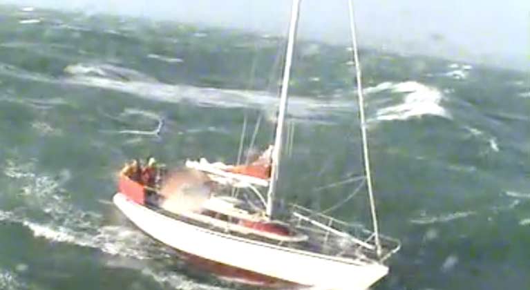 Conditions were extremely challenging with force nine winds with a six metre sea swell when Rosslare RNLI went to rescue this yacht in the Irish Sea
Finally, there’s the episode of that rescue by the Rosslare Lifeboat of a yacht in distress at the height of the storm. Some day we’ll learn just how the yacht was there at all, for heaven knows Ophelia had been well signaled for days in advance. But oddly enough, that’s not too important this morning, What is important is that Cox’n Eamonn O’Rourke and his crew – all volunteers – were assembled within minutes, they carried out a text-book rescue with clinical precision, and the country could return to keeping itself safe for the day, as we’d been advised to.
Because although there’d been some grumblings that the warnings beforehand were surely tending towards exaggeration, they weren’t. The three tragic deaths were three deaths too many, and infinitely sad. But yesterday could have been a continuing litany of personal tragedies if people had deluded themselves that they could have got away with cheating such a prodigious force of nature.
So we emerge from our encounter with Storm Ophelia with a heightened sense of ourselves as a mature nation. Ireland is unique – a medium-sized island on the leeward side of one of the roughest oceans in the world. Our population is such that we have to stretch resources to provide the services and expertise which countries with larger populations can take in their stride.
Yet when Storm Ophelia tested those services, Ireland was not found wanting. And we Irish conducted ourselves like sensible adults who will accept a certain amount of discipline when it is presented to us in a competent and reasonable manner.
On this, the day after the storm, we can feel quietly proud of being Irish.
Coast Guard Warns of Heavy Swell on Atlantic Coast
The Coast Guard advises caution to public as Met Éireann warns of heavy swell on Atlantic Coast later on Sunday.
Members of the public have been urged to heed the advice of the Coast Guard as Met Éireann has issued a status yellow wind warning with some very strong west, veering northwest winds expected to affect western and south western coastal counties later Sunday, overnight and into Monday morning with very high seas along the coasts during this period.
The Coast Guard advises the public to be careful on exposed coasts, cliffs and piers, harbour walls and promenades along the Atlantic seaboard particularly at high tide.
Remember to Stay Back, Stay High and Stay Dry.
If you see someone in difficulty in the sea, on the shore dial 999/112 and ask for the Coast Guard.
Say Hello to Storm Jake
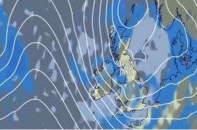
Storm Jake has been officially named by Met Éireann. The strongest gusts will mainly affect Ireland with lower impacts for the UK.
Winds will strengthen around southwest parts of the UK through this morning, particularly as a band of showers moves southeastwards across parts of Wales and southwest England.
Along the band of showers there is scope for some locally squally winds and so disruption to travel but the period of strongest winds will be short lived.
Latest track of Storm Jake#StormJake has been officially named by Met Éireann. The strongest gusts will mainly affect Ireland with lower impacts for the UK.Winds will strengthen around southwest parts of the UK through Wednesday morning, particularly as a band of showers moves southeastwards across parts of Wales and southwest England. Along the band of showers there is scope for some locally squally winds and so disruption to travel but the period of strongest winds will be short lived.
Posted by Met Office on Tuesday, 1 March 2016


 Michael Murphy Schull Harbour Sailing Club (SHSC), Eric Coogan Heineken Ireland, Mark Murphy, Commodore SHSC, Jack Allen SHSC, Carmel O'Regan SHSC, Cornelious Ndlovu, Schull Harbour Hotel Operations Manager and Derval Murphy SHSC")


