


Displaying items by tag: marine mapping
Hydrographic and geophysical survey operations will be undertaken by INFOMAR in the Celtic Sea and Atlantic Ocean between April and October this year, according to a recent Marine Notice from the Department of Transport, Tourism and Sport.
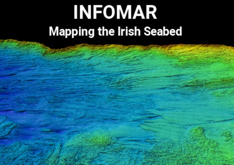
Covering some 125,000 sq km of underwater territory, INFOMAR will produce integrated mapping products covering the physical, chemical and biological features of the seabed.
Both Marine Institute vessels, the RV Celtic Voyager (callsign EIQN) and RV Celtic Explorer (callsign EIGB), will be employed for these survey operations, towing a magnetometer sensor with a single cable of up to 200m in length and a Moving Vessel Profiler cable of variable length up to a maximum of 200m.
Geological Survey Ireland will also operate four vessels, the RV Keary (callsign EI-GO-9), RV Geo (callsign EI-DK-6), RV Mallet (callsign EI-SN-9) and RV Lir (call sign EI-HI-2).
All vessels will display appropriate lights and markers and will be listening on VHF Channel 16 throughout the course of the survey.
Further details, including co-ordinates of the survey areas, are included in Marine Notice No 11 of 2020, a PDF of which is available to download below.
INFOMAR Marine Mapping Pledge of €15m Over Five Years
Minister for Natural Resources, Fergus O'Dowd, T.D. today set out details of upcoming projects in the National Marine Mapping Programme (INFOMAR), and pledged Government commitment of €15m for the next 5 years, for the continuation of what he called "the most valuable resource for marine research and development in Ireland and beyond".
Covering some 125,000 square kilometres of underwater territory, the INFOMAR project is producing new mapping and integrated products covering the Irish maritime space. It provides seabed surveys, which are used in all activities from planning for offshore renewable energy projects to ensuring shipping lanes are safely charted.
Commenting today, Minister O'Dowd said: 'I am delighted to announce the continuation of the INFOMAR project. This is a world class undertaking which is providing crucial information towards the development of Ireland's 220 million acres that lie under the sea. I am particularly pleased to see the programme focus on adding value to the data and ensuring INFOMAR plays it's part in developing jobs and growth,"
The decision to continue the project was taken following a second full independent review of its operations by PricewaterhouseCoopers. The initial review, undertaken in 2008, concluded that the benefits to the state of completing the project are between 4 and 6 times the cost. The second review showed the project to be on track and recommended accelerated development of business and educational applications. Dublin Business Innovation Centre (DBIC) have now been contracted to work with the project on this area, including new products, apps, and educational resources.
In the eight years since it began, the INFOMAR project has conducted detailed surveys along the SouthWest, South and East coasts and completed mapping of most Irish bays and harbours including, Dublin, Cork, Shannon and Galway. To date the programme has helped produce:
New navigational charts
Shipwreck maps and books
New Marine Special Areas of Conservation
Data to underpin Foreshore Licensing
Maps for offshore renewable planning, cable and pipeline routes
Ireland's largest digital database of marine information
The programme is funded by Department of Communications , Energy and Natural Resources and managed by Geological Survey of Ireland (GSI), in conjunction with the Marine Institute (MI). Mapping is carried out using all of the states marine research vessels, the Celtic Explorer and Voyager managed by MI and the Keary, Geo and Cosantoir Bradan managed by GSI. The next phase of the project will include mapping of Lough Foyle, Lough Swilly, Broadhaven Bay, Youghal, Dungarvan and Drogheda. It will also see the launch of a range of new services, reports and apps.


 Michael Murphy Schull Harbour Sailing Club (SHSC), Eric Coogan Heineken Ireland, Mark Murphy, Commodore SHSC, Jack Allen SHSC, Carmel O'Regan SHSC, Cornelious Ndlovu, Schull Harbour Hotel Operations Manager and Derval Murphy SHSC")


