


Displaying items by tag: Navigation
Placement Of New Navigational Aid In Lough Ree
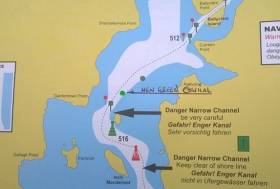
#InlandWaters - Waterways Ireland advises masters and users of the Shannon Navigation that a new green conical navigation aid has been placed north of Inch Macdermot Island in Lough Ree between the green perch and the green can buoy, as shown on the guide above.
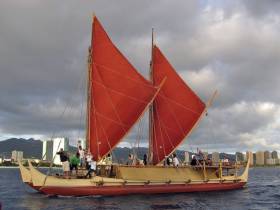
#Offshore - Just in time for the release of Disney’s new seafaring adventure Moana comes this National Geographic profile of a team of sailors recreating the incredible navigations of Polynesian boats that inspired the animated film.
The crew of the Hōkūle‘a sail the ocean with nothing but the sun and the stars to guide them — even watches are banned.
And the Hawaiian team have been doing it since the mid 1970s, on a mission to prove their Polynesian ancestors were master navigators of the vast expanse of the Pacific.
They’ve since rekindled a long-lost seafaring tradition across the Polynesian islands, and have set their sights on completing an audacious 60,000-nautical-mile round-the-world voyage that they began in 2013, all on an open-deck double-hulled voyaging canoe.
National Geographic has more on the story HERE.
Marine Notice: Caution On Use Of Unlicensed Electronic Navigational Systems & Software
#MarineNotice - Marine Notice No 4 of 2016 advises of the risks inherent in the use of unlicensed electronic navigation systems and cautions against their use.
Unlicensed software and electronic charts may contain errors, resulting in inaccuracies in displayed information and indicated vessel position. Such unlicensed software should not be used for navigation purposes.
Vessel operators are reminded of the requirement to carry suitable nautical instruments and adequate and up-to-date charts for their intended voyages. All equipment fitted in compliance with shipborne navigational equipment regulations should be type approved.
The installation and use of unlicensed navigational systems and software on-board commercial vessels may invalidate a vessel’s certification and may also lead to the cancelation of a vessel’s certificates.
If in doubt, vessel owners/operators should confirm with their suppliers that their software is up to date and licensed.
Dead Floating Cows Can Be Navigational Hazards
#deadcow – Round–the–World Yachtsman and Afloat.ie reader Pat Murphy says he enjoyed our story about the weekend rescue of a cow by the RNLI in Waterford. Unfortunately, Pat and his wife Olivia related a tale where they came across another cow in the same area (above) that was not so lucky. 'We came across him/her about six miles south of Hook Head while on passage from Waterford to Padstow in Cornwall on August Monday last in our yacht Aldebaran', Pat told Afloat.ie.
'I reported it to Rosslare Coastguard Radio as a navigational hazard. It was so bloated I think that to make contact with it could result in a not very nice shower!' he said.
Low Water Levels Advisory For Ireland's Inland Navigations
#InlandWaters - Despite the threat of floods amid the current weather warning, the recent extended period of dry weather has meant that water levels in Ireland's navigable inland waterways are lower than normal for this time of year.
Where water levels fall below normal summer levels, Waterways Ireland says masters should be aware that their vessels may be at risk of grounding, particularly deep drafted vessels.
To reduce this risk, masters should navigate where possible on or near the centreline of the channel and also avoid short cutting in dog-legged channels and navigating too close to navigation markers.
Proceeding at a slow speed will also reduce 'squat' effect, ie where the vessel tends to sit lower in the water as a consequence of higher speed.
Low water levels will also impact on slipways, with reduced slipway length available under the water surface and the possibility of launching trailers dropping off the end of the concrete apron onto the river/lake bed and causing damage to trailer, outboard motor or boat.
More slipway surface will also be susceptible to weed growth requiring care while engaged in launching boats.
Very dry riverbanks are more susceptible to erosion from vessel wash. Waterways Ireland asks masters to ensure they adhere to the speed limits and maintain a reduced wash.
Where appropriate by maximising on the number of vessels in a lock the total volume of water moving downstream is decreased. This also reduces the volume of water used.
Waterways Ireland asks users to be patient and wait for other boaters to share the lock rather than using locks for single passages.
Masters are also requested to make sure lock cycles are used for vessels travelling each way. Each lock cycle should take boats both up and down stream. All sluice gates and paddles should be shut when leaving a lock.
In addition, masters are reminded not to leave taps running at watering points or service blocks in the interest of water conservation.
New Edition Of 'Learn To Navigate' Continues Its No-Nonsense Reputation

#HowToNavigate - A new revised edition of bestselling sailing guide Learn to Navigate continues its reputation as the accessible, no-nonsense guide for every boater.
Basil Mosenthal and Barry Pickthall take the reader through every step, from reading charts to understanding tides and much more, giving even novice sailors a sound practical basis in navigation.
Learn to Navigate is available now via Amazon and all good nautical booksellers.
End Of An Era For Paper Navigation Charts In US Waters

#Navigation - The United States' National Oceanic and Atmospheric Administration (NOAA) has announced that it will cease publication of paper nautical charts in six months' time, according to Sail magazine.
Since the first maps charting the US coastline were published in the 1860s, the NOAA's Office of Coast Survey has been producing accurate and highly detailed charts to help all kinds of mariners find safe passage through American waters, from fishing vessels to merchant ships to cruising yachts.
But with the majority of ocean-goers now relying on GPS and other modern technologies, the use of paper nautical charts was seen as falling by the wayside by the Federal Aviation Administration (FAA), which took over the production of US charts in 1999.
Yet while printed nautical charts may now become the preserve of specialised cartographers like Bobby Nash, who designed a special classic chart for the Volvo Ocean Race finale in Galway last year, the NOAA will still be providing its ocean maps by electronic means via data or high-res PDFs.
Sail magazine has more on the story HERE.

#Navigation - Marine navigation systems in yachting and shipping are 'primitive' compared to the standard in air travel, according to an electronics expert.
As Yachting Monthly reports, Martin Bransby of the UK's General Lighthouse Authorities said that "demands on marine navigation are only getting tighter, yet electronic systems at sea a primitive compared to those used in air travel. This needs to change."
Bransby made his comments following a trial to tackle the problem of rogue GPS jammers in the North Sea by the lighthouse authorities at Trinity House.
The new PNT (positioning, navigation and timing) method uses new technology to transmit critical data in the even of the loss or failure of GPS, which is vulnerable to interference from a variety of sources, both environmental and deliberate.
"The more dependent we become on electronic systems, the more resilient they must be," said Bransby. "Otherwise, we face a scenario where technology is actually reducing safety rather than enhancing it."
These new trials come after news that the Irish Coast Guard is collaborating on a new system of marine monitoring that will help detect drifting or rogue vessels in international waters before they become a problem for individual states - such as the 'ghost ship' MV Lyubov Orlova which as of last week was still adrift heading eastwards somewhere in the North Atlantic.
GPS Backup Goes Live in World's Busiest Shipping Lane
#Shipping - The General Lighthouse Authorities of the UK and Ireland (GLA) have announced that ships in the Port of Dover, its approaches and part of the Dover Strait can now use eLoran radio navigation technology as a backup to satnav systems like GPS and Galileo.
The ground-based eLoran system provides alternative position and timing signals for improved navigational safety.
The Dover area, the world's busiest shipping lane, is the first in the world to achieve this initial operational capability (IOC) for shipping companies operating both passenger and cargo services.
This recent announcement represents the first of up to seven eLoran installations to be implemented along the East Coast of the United Kingdom.
The Thames Estuary and approaches up to Tilbury, the Humber Estuary and approaches, and the ports of Middlesbrough, Grangemouth and Aberdeen will all benefit from new installations, and the prototype service at Harwich and Felixstowe will be upgraded.
Although primarily intended as a maritime aid to navigation, eLoran could become a cost-effective backup for a wide range of applications that are becoming increasingly reliant on the position and timing information provided by satellite systems.
"Our primary concern at the GLA is for the safety of mariners," said Ian McNaught, chief executive of Trinity House, "But signals from eLoran transmitters could also provide essential backup to telecommunications, smart grid and high frequency trading systems vulnerable to jamming by natural or deliberate means.
"We encourage ship owners and mariners to assess eLoran in this region and provide feedback to the GLA on its performance."
P&O Ferries has installed an eLoran receiver on its new vessel Spirit of Britain. She will be based at Dover and is one of the largest passenger ships the busy Dover/Calais route has ever seen.
"Accurate real-time positional information is essential for the safe navigation of ships with modern electronic charts," said Captain Simon Richardson, head of safety management at P&O Ferries.
"Satellite navigation systems are vulnerable to degradation of signal strength and our ships have also experienced occasional loss of signal.
"We welcome the development of a robust alternative to provide redundancy in real-time positional information and we see eLoran as the most effective solution to countering the problem."
Commenting on the announcement, Britain's Shipping Minister Stephen Hammond said: "I congratulate the General Lighthouse Authorities on this initiative which seeks to improve navigational safety in what is the busiest shipping channel in the world, through the development and deployment of technology. I look forward to receiving reports of its effectiveness."
Belfast Harbour Notice: Changes to Navigation and Traffic Aids
#BELFAST HARBOUR - Mariners using Belfast Harbour are advised of a number of changes made to buoys placed in Belfast Lough to aid in navigation and traffic management.
The existing Fairway Buoy has been moved east northeast (ENE) to a new position, while four new buoys have been added - two at the main approach to the Port of Belfast, and two further out in the lough at Kilroot and Helen's Bay.
Vessels heading into the Port of Belfast are to pass north of the repositioned Fairway Buoy, while outward vessels must now pass south of the buoy, both reporting to Belfast Harbour Radio on VHF Channel 12.
Moreover, all vessels arriving to and departing from Belfast Harbour, when proceeding to or from anchorages or other berths within Belfast Lough, are requested to make contact with Belfast Harbour Radio to confirm their passage plans whether inbound (15 minutes from the Fairway), outbound (on passing Beacon No 12) or on heaving anchor.
Full details of co-ordinates of the new buoy placements are included in Belfast Harbour Notice No 20 of 2012, a PDF of which is available to read or download HERE.


 marks the retirement of long-serving IMF board member Bernard Gallagher after today's IMF agm at Dun Laoghaire, Co.Dublin. Gallagher, a previous IMF Chairman and a member of numerous committees within the federation has served the industry for over 40 years")


 Michael Murphy Schull Harbour Sailing Club (SHSC), Eric Coogan Heineken Ireland, Mark Murphy, Commodore SHSC, Jack Allen SHSC, Carmel O'Regan SHSC, Cornelious Ndlovu, Schull Harbour Hotel Operations Manager and Derval Murphy SHSC")


