


Displaying items by tag: EirGrid Interconnector
Marine Notices: ADCP Deployment In Waterford Harbour, EirGrid Interconnector Cable Survey In Irish Sea
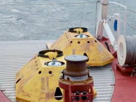
TechWorks Marine Ltd is deploying trawl-resistant bottom mounted Acoustic Doppler Current Profiler (ADCP) frames in Waterford Harbour this week.
It is anticipated that the ADCPs will be deployed between today, Monday 8 July, and this Friday 12 July, depending on the weather. If the deployment is delayed due to the weather, it will be carried out on the next viable tide and weather window. Update: the ADCPs will now be deployed on or after Thursday 18 July.
The frames will be deployed from the vessel James (callsign EITT2). The frames will be on the seafloor for a minimum period of one calendar month and a maximum period of two months (weather permitting).
The ADCPs will be measuring currents through the water column at each location over the deployment. This data will be used to validate a hydrodynamic model of the area being developed for Irish Water.
Each frame will have one ADCP sensor, an acoustic pinger, an acoustic release and a rigid recovery buoy.
The frames are approximately 1m2 and will remain on the seafloor for a period of up to 30 days, after which the frame will be retrieved using the acoustic release and recovery buoy.
There will be no surface marker during the extent of deployment so vessel traffic will not need to avoid the area but should be aware of its presence.
Details of the relevant co-ordinates are included in Marine Notice No 22 of 2019, a PDF of which is available to read or download HERE.
Meanwhile, planned cable survey works on the EirGrid East West Interconnector are being carried out by the vessel Deep Helder (callsign PBYU) until this Thursday 11 July. During this survey, the vessel will be deploying underwater survey equipment along a thin 50m corridor.
Fishermen are advised not to leave any static fishing equipment in the vicinity of the survey route (250 metres) and keep a safe distance of at least one nautical mile from the survey vessels that will be operating with towed equipment and will have restricted manoeuvrability.
In addition, the survey vessel Ping will carry out operations in the near-shore waters off Rush, Co Dublin from next Monday 15 July. Near-shore survey operations will take place between beach HW mark and the 10m water depth contour.
Details of co-ordinates and survey contacts are included in Marine Notice No 21 of 2019, a PDF of which is available to read or download HERE.


 marks the retirement of long-serving IMF board member Bernard Gallagher after today's IMF agm at Dun Laoghaire, Co.Dublin. Gallagher, a previous IMF Chairman and a member of numerous committees within the federation has served the industry for over 40 years")


 Michael Murphy Schull Harbour Sailing Club (SHSC), Eric Coogan Heineken Ireland, Mark Murphy, Commodore SHSC, Jack Allen SHSC, Carmel O'Regan SHSC, Cornelious Ndlovu, Schull Harbour Hotel Operations Manager and Derval Murphy SHSC")


