


Displaying items by tag: Geophysical
The first in a series of hydrographic and geophysical surveys to be undertaken in the Celtic Sea and Atlantic Ocean under the INFOMAR programme between April and October 2019 is now under way.
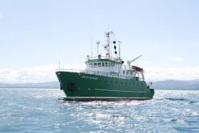
The RV Celtic Voyager (callsign EIQN) set off on Friday 12 April for an 18-day survey, the first of four over the next five months 18 May-6 June, 12-28 July, 29 August-14 September).
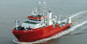
The RV Celtic Explorer (callsign EIGB) will follow up with an 18-day survey from 21 September to 8 October. Both vessels will be towing a magnetometer sensor with a single cable of up to 200 metres in length.
Other survey vessel involved include the Geological Survey Ireland vessels RV Keary (callsign EI-GO-9), RV Geo (callsign EI-DK-6), RV Mallet (callsign EI-SN-9) and RV Lir (callsign EI-HI-2).
All will display appropriate lights and markers and will be listening on VHF Channel 16 throughout the course of the surveys.
Full details of the survey areas are included in Marine Notice No 8 of 2019, a PDF of which is available to read or download HERE.
Providence Resources Conducting Geophysical Survey off South West Coast of Ireland
The Department of Transport, Tourism and Sport has been advised that Orbis Energy Ltd on behalf of Providence Resources PLC will commence a Geophysical survey which will be undertaken approximately 220 kilometres off the South West Coast of Ireland, involving multi-beam echosounder, dual frequency sidescan sonar and sub bottom profiler assisted by the use of an Autonomous Underwater Vehicle (AUV) operated in close proximity to the vessel. The survey will also include shallow geotechnical sampling and an Environmental Baseline Survey.
The survey is anticipated to commence on Sunday 19th February 2017 and the estimated duration is 6 days, weather permitting. The latest completion date for the survey will be the 19th March 2017.
The Fugro Searcher (call sign: 3EUY6) is scheduled to carry out the work. The vessel will be listening on VHF Channel 16 at all times.
Survey Area
|
Ref |
Latitude |
Longitude |
|
1 |
50°47’53.707”N |
12°59’09.114”W |
|
2 |
50°47’21.570”N |
12°57’15.670”W |
|
3 |
50°46’13.075”N |
12°58’08.342”W |
|
4 |
50°46’31.708”N |
12°59’22.783”W |
|
5 |
50°46’43.146”N |
12°59’53.952”W |
|
6 |
50°47’07.564”N |
12°59’44.993”W |
Greater Work Area
|
Ref |
Latitude |
Longitude |
|
1 |
50°49’17.471”N |
12°59’58.095”W |
|
2 |
50°47’55.122”N |
12°55’05.392”W |
|
3 |
50°44’50.814”N |
12°57’13.742”W |
|
4 |
50°46’12.099”N |
13°02’06.913”W |
All vessels, particularly those engaged in fishing, are requested to give the survey site a wide berth and to keep a sharp lookout in the relevant areas.
The Survey Vessel will be displaying visual indicators on the mast during daylight and lights during the night to advise other mariners of their restricted manoeuvrability.
All mariners are reminded of their responsibilities under the International Collision Regulations and are reminded of Marine Notice No. 17 of 2007, which gives general advice in relation to the activities of vessels engaged in survey work for hydrographic, seismic, fishing research and underwater operations.
The International Regulations for Prevention of Collisions at Sea (COLREGS) are implemented in Irish law by the Merchant Shipping (Collision Regulations) (Ships and Water Craft on the Water) Order 2012 [S.I. No. 507 of 2012], and the Signals of Distress (Ships) Rules 2012 [S.I. No.170 of 2012]. See Marine Notice No. 06 of 2013. These Statutory Instruments may be purchased by mail order from Government Publications, Office of Public Works, 52 St. Stephen’s Green, Dublin 2. Tel: (01) 6476834/1890-213434. They are also available online at: www.irishstatutebook.ie.
Marine Notices are issued purely for maritime safety and navigation reasons and should not be construed as conferring rights or granting permissions.


 marks the retirement of long-serving IMF board member Bernard Gallagher after today's IMF agm at Dun Laoghaire, Co.Dublin. Gallagher, a previous IMF Chairman and a member of numerous committees within the federation has served the industry for over 40 years")


 Michael Murphy Schull Harbour Sailing Club (SHSC), Eric Coogan Heineken Ireland, Mark Murphy, Commodore SHSC, Jack Allen SHSC, Carmel O'Regan SHSC, Cornelious Ndlovu, Schull Harbour Hotel Operations Manager and Derval Murphy SHSC")


