


Displaying items by tag: Navigation
Notice on Mandatory Training for Navigation by ECDIS

The latest Marine Notice from the Department of Transport, Tourism and Sport details the training requirements for the use of Electronic Chart Display and Information Systems (ECDIS) as a primary means of navigation.
Mandatory carriage requirements for ECDIS will be phased in between 1 July 2012 and 1 July 2018 according to ship size and class. All shipowners, masters and deck officers of merchant and fishing vessels, yachtsmen, nautical colleges and other users are required to complete both generic and ship specific training for the use of ECDIS.
The notice outlines the following as meeting the requirements for generic training:
- A NARAS Operational course completed after 1 January 2005.
- An ECDIS programme based on the IMO Model ECDIS course (1.27) approved by the Irish Maritime Administration.
- An ECDIS programme based on the IMO Model ECDIS course (1.27) approved by the maritime administration of an EU Member State or by a country recognised by Ireland under STCW 78.
As far as ship-specific training, the following areas should be covered in training delivered by the ECDIS manufacturer (computer-based training packages are acceptable):
- familiarisation with available functions
- familiarisation with the menu structure
- display setup
- setting of safety values
- recognition of alarms and malfunction indicators and the actions to be taken
- route planning
- route monitoring
- changing over to backup systems
- loading charts and licenses
- updating of software
Further details are available in Marine Notice No 51 of 2011, available to read or download as a PDF HERE.
Navigating With the IPhone

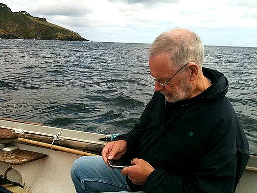
Dag Pike talks us through the fact the ubiquitous IPhone will do nearly anything that you ask it to and it even makes phone calls. Much of what it does is related to land-based applications but now the boundaries are becoming blurred and the IPhone can become a wonderful navigation device for use at sea.
I am sure that many of you have already discovered the virtues of the IPhone and the more I use it for navigation, the more I discover what it will do. The problem is to narrow down what you want the phone to do rather than being distracted by the wide variety of applications on offer that will run your life if you let them.
It sounds too good to be true and in some ways it is. Being a small portable package makes it vulnerable. You might drop it, you might loose it, you might have a flat battery, or it might just stop working, so you could be vulnerable if you put all your trust into this one unit. For many, there has been safety in the philosophy of having each navigation requirement contained in a separate unit, then if one fails then you still have the other to keep you going. I would be very nervous about putting all my navigation requirements into the one IPhone when I was out at sea but where the IPhone would perform very well would be as a back-up to the conventional navigation systems and it would still remain working if all your electrics failed.
Let's have a closer look at each navigation requirement that can be provided by the IPhone and this will give a better picture of what can and cannot be done with the IPhone.
Communications
You can make phone calls and send text messages and have Internet access using the IPhone wherever there is coverage for the provider that you are using. If you want to get sophisticated, then you need the 3G coverage and that tends to be less extensive, particularly out at sea. For normal phone coverage, you can be pretty certain of coverage up to 5 miles offshore and in many areas up to 10 miles but after that it can be a bit hit and miss. There will always be dead spots that the signal cannot reach, particularly along a rocky coastline where there are cliffs, but this can be a problem with marine VHF as well.
Whilst there are detailed maps showing the mobile phone coverage on land there are none for sea coverage so you can only learn what is available when you are out there. You should have a VHF radio on board as well as an IPhone so that you can hear distress messages and send out your own if you are in trouble but more and more these days boaters are using mobile phones to communicate for routine matters such as organising a berth in a marina and you certainly don't want to be thinking about using the VHF to book a table in a restaurant.
With the Navionics navigation package on your IPhone, I love the way that you can just tap on a port or marina and up will come the telephone number. One more tap on the screen and the phone is ringing.
GPS Reception
GPS is the key to position fixing and the IPhone has a built in receiver that should know where you are all the time. However, you will notice that your conventional chart plotter has its GPS antenna located outside the boat to ensure continuous reception. Your IPhone GPS will have its antenna inside the boat most of the time so you will need to check whether the GPS is working here. It may work under the windscreen and it should certainly work in an open boat or on the flybridge but GPS reception is certainly something to check out before you commit yourself to IPhone navigation. I use the Pocket GPS World App because this shows you the reliability of the position information being produced by the GPS and you should consider this vital information.There are very cheap or free GPS Apps that you can download that will show your position, speed course etc, which you could use in conjunction with paper charts if you just want to simplify your IPhone navigation.
Navigation
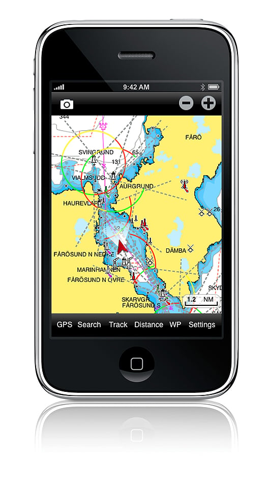
There is no doubt in my mind that that the Navionics App is the best one both for route planning and for navigation itself. This system has rave reviews and it works extremely well by offering most of the facilities that are found on mainstream chart plotters on the small screen of the IPhone. There is virtually worldwide chart coverage and you simply download the App that is relevant to the area you plan to sail in. For instance you can get chart coverage of the whole of the UK and Northern Europe for the price of a couple of bottles of wine.
It is the compact size of the screen that can make things difficult but you soon get used to this. When you are plotting a route, you need to take extra care that the route you have chosen is free from dangers and this can only be done by expanding the scale and then carefully studying the route in detail. I found it too easy to set the waypoints out and then find that the chosen route passes over a rock or a shoal that does not show up too well on the small screen or the scale that you are using.
You set the waypoints by selecting WP and then simply tapping the screen and with big fingers, it is not easy to set them accurately. However, they are easy to adjust, again by simply touching the way point and dragging it to where you want it to be. It took me 5 minutes to plot a route involving 10 waypoints and that including checking it out afterwards.
Once plotted all you need to do is keep the 'own ship' icon on the course line to follow the route. You can set the track plotting mode so that you have a record of where you have been and you get a heading vector and a speed read-out provided that you are doing more than 5 knots. That might be a handicap for sail boats because that heading vector is particularly useful to see where you are going in relation to the plotted route.
Don't take for granted that the GPS plot is giving accurate information. As mentioned above, I like to get a check on the quality of the GPS fix because when I was testing the IPhone, there were a couple of times when it plotted over the land and I was confident that I was on the water.
The Navionics App also has tidal and current information for 7 days ahead for a variety of locations around your position. There is so much information built into the system that you have virtually everything at your fingertips. However, there are some things that it will not do such as showing you the total distance of a route you have plotted and the courses and distances of each leg of the route. That said, the Navionics App has to be one of the most useful for those who want to navigate on the water.
AIS
You cannot get a direct read-out from the AIS transmitters around you because you need VHF for that but the next best thing is the Ship Finder App. With this App you can go to nearly any location around the world and it will show you the ships and boats that are transmitting their AIS signals. Tap on any one of the ship icons and it will show you all the details of the ship including its size, destination and course and speed. This function is more of interest than a serious navigation tool but it could be useful to indentify a ship out at sea and to give some idea of where it might be heading.Compass
The IPhone has a built-in compass but there are also a number of Apps available with alternative compass displays. The standard display shows both an analogue and a digital read-out of the heading and checking this out at sea, it seems to be reasonably accurate, say to within 5°. The reason it is hard to get better accuracy is that the heading shown is the way that the IPhone is pointing and it is hard to get this lined up exactly with the bow of the boat. It only wants a slight movement of the phone to change the heading by several degrees. However as an emergency compass it works and you have the choice of the readout in either true or magnetic headings.
Weather
If your IPhone is connected to the Internet then you can access all the web sites that offer weather information. However I use an App called Weather Pro that will give you detailed 7 day weather at any port you programme in. The forecast is given for every 3 hours and details thing like wind strength and direction as well as predicted wind gust speeds. However, you do need to be aware that these are basically land forecasts and the conditions at sea could vary a little.
Comments
Every time that I have used the IPhone for navigation I have been amazed at its capabilities. It gives you so much information in such a small package that you will wonder how you ever managed without it. This really is the problem because in time you will take everything the IPhone can do for granted and you will no longer check that it is giving good quality navigation information. The biggest worry is the quality of the GPS position information because much of the navigation depends on this. I used the App that tells you the quality of the GPS fix but that means switching over to this at frequent intervals. It would be much better to have an automatic system that throws up an alarm when the GPS position is poor. I am sure that will come with time.
I would be nervous if the IPhone was my only source of navigation information. It is easily dropped, it is not waterproof and the battery has only a limited life. Of course, you can mount it into a holder and you can keep the charger plugged in to overcome the battery life problem and you can get extra life batteries. Where the IPhone scores is that it makes a great back-up system that will cover most of your navigation needs. In this respect, it could replace the hand held GPS and the hand- held VHF to a certain extent but before you throw these items away, I would suggest that you get a lot of experience with IPhone navigation. Only then will it become the true navigation friend that this remarkable piece of equipment is.
Sunken Vessel Presents Hazard on the Shannon

It is intended to lift this vessel using a pontoon and lifting equipment on Thurs 30 Jun 2011, commencing at 08.00hrs. It is expected that the operation will take four hours. Masters should expect to be delayed when passing through the area.
All vessels passing the pontoons should exercise due caution and heed the advice and instructions of the safety boat in attendance.
Southbound vessels in particular should be aware of their speed as they approach the navigation arch with the attending flow in order to avoid a close quarters situation with the pontoon. Use of extra fenders in the bow area of vessels would be a prudent precautionary measure when passing the lifting rig.
Dublin to Manage Dundalk Port
"In order to ensure the orderly management of the company's affairs, I have decided that the best course of action is to transfer responsibility for the port to Dublin Port Company. I would be hopeful that port activities will continue at Dundalk following the transfer.
He added, once the current difficulties are overcome, it may be the case that Dundalk Port can return to local control, in cooperation with the local authority and private sector operators.
To amalgamate the two port companies a Transfer Order will be made under the Harbours Act 1996. In addition a draft order has to be approved by both Houses of the Oireachtas before being signed into law which is expected to take place within the coming weeks.
The Co. Louth port which is equidistant between Dublin and Belfast, has shown to have a long history as an independent seaport. However the recession has had a significant impact making trading conditions particularly difficult for the company. At its peak in 2006 there were over 220 vessels calling at the port but dropped to just over 60 vessels last year. Figures for 2011 show no signs of improvement.
Vessels of up to 3,500 dwt and 106m in length can be handled at the port's six berths. Unusally for an Irish port vessels can be seen resting on the mudbank subject to the state of the tide. The port is some 8kms from the open sea and is reached along a narrow channel which requires the compulsory use of a pilot.
End of Winter Mooring Period in Public Harbours
Ireland's Fog Signals to Fall Silent
Nine lighthouses operated directly by the authority in the Republic and Northern Ireland, along with several others run by harbours or local authorities - including Cork Harbour and Dun Laoghaire - will sound their last fog signals tomorrow.
Capt Kieran O'Higgins of the Commissioners of Irish Lights said the plan was notified to mariners in September 2010, and was taken due to "advances in marine navigation technology".
However Capt Michael Coleman, formerly of the Jeanie Johnston, did not think the plan was adequately publicised. He also noted now many smaller boats without advanced equipment that navigate by charts often reply on fog signals for safe passage.
Even bigger boats that navigate by GPS could be affected in dangerous situations if they suffer a power failure, he said.
On Afloat's official Facebook page, Cork resident Denis Cronin commented: "If this is the last night the [Cork Harbour] fog horn blows, it's a sad night.
"The tune she blows is a comfort for all those at sea and for all those at home for been home safely."
What do you think of the end of Ireland's fog signals? HAVE YOUR SAY on our facebook page HERE!
BBC Article HERE
Irish Times Article HERE
Irish Vessels Require Communications Licence
In order to comply with these regulations, Ireland accepts the following documents as meeting the requirements on board its vessels:
To view the regulations in greater detail logon HERE


 Michael Murphy Schull Harbour Sailing Club (SHSC), Eric Coogan Heineken Ireland, Mark Murphy, Commodore SHSC, Jack Allen SHSC, Carmel O'Regan SHSC, Cornelious Ndlovu, Schull Harbour Hotel Operations Manager and Derval Murphy SHSC")


