Menu

Ireland's sailing, boating & maritime magazine

Displaying items by tag: Hydrographic

The first in a series of hydrographic and geophysical surveys to be undertaken in the Celtic Sea and Atlantic Ocean under the INFOMAR programme between April and October 2019 is now under way.

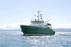
The RV Celtic Voyager (callsign EIQN) set off on Friday 12 April for an 18-day survey, the first of four over the next five months 18 May-6 June, 12-28 July, 29 August-14 September).

The RV Celtic Explorer (callsign EIGB) will follow up with an 18-day survey from 21 September to 8 October. Both vessels will be towing a magnetometer sensor with a single cable of up to 200 metres in length.

Other survey vessel involved include the Geological Survey Ireland vessels RV Keary (callsign EI-GO-9), RV Geo (callsign EI-DK-6), RV Mallet (callsign EI-SN-9) and RV Lir (callsign EI-HI-2).

All will display appropriate lights and markers and will be listening on VHF Channel 16 throughout the course of the surveys.

Full details of the survey areas are included in Marine Notice No 8 of 2019, a PDF of which is available to read or download HERE.

Published in Marine Science
High Resolution images of a merchant ship which was sunk ninety-four years ago today (October 12th) off the coast of Dublin have been revealed by the INFOMAR (Integrated Mapping For the Sustainable Development of Ireland's Marine Resource) Programme during a mission on the national research vessel the RV Celtic Voyager earlier this year which surveyed the wreck of the first Guinness merchant vessel, the W.M. Barkley.

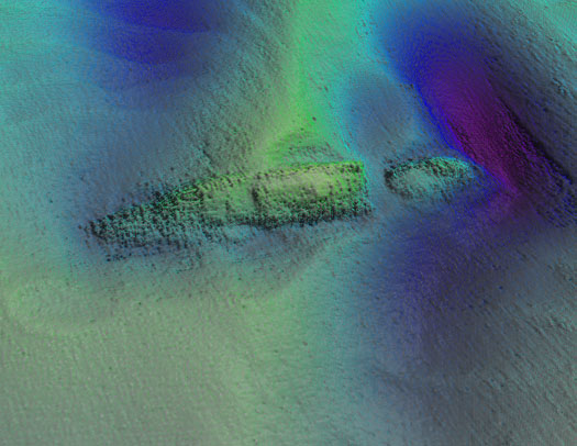
The detailed seabed images, which include deck features and complex sand wave structures, were recorded by towed sidescan sonar provided by the Moore Marine Group, and give a visual insight into the defensively armed ship that was sunk by a German torpedo in 1917, seven miles east of the Kish Bank off Dublin.
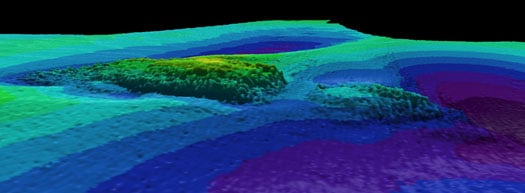
Photo_1_INFOMAR_image_of_W_M_Barkley_from_port_aft

Photos above and below show topographic seafloor images in 3D, showing the partially buried wreck of the W M Barkley lying at a water depth of 56 metres; with deeper scouring around it down to 72 metres (darker colours indicate greater depths). The images were created from sonar data acquired onboard the Marine Institute's research vessel RV Celtic Voyager, during INFOMAR Programme mapping in 2010 and 2011 with data processed by INFOMAR's Fabio Sacchetti (University of Ulster) and Charise McKeon (Geological Survey of Ireland).
W_M_Barkley

In May 2010, during a large scale mapping survey in the Irish Sea by INFOMAR, a national marine study run by the Marine Institute and the Geological Survey of Ireland, identified a seabed feature which, to the trained eye, was discernable as a potential shipwreck lying in the same position recorded on the Admiralty Chart, the EU wreck site and UK Hydrographic Office wreck site directories, as well as a survey conducted in the 1980s as the last known position of the W.M.Barkley.

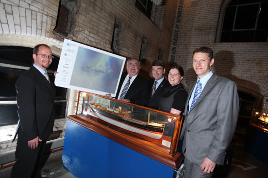
Viewing the spectacular imagery of the shipwreck Minister for Communications, Energy & Natural Resources, Pat Rabbitte, said "I am delighted to note the continued excellence of the valuable work being carried out under the INFOMAR project. These images from the deep reveal a unique view of part of Ireland's marine heritage and I am delighted to announce details of INFOMAR''s annual seminar to be held in Galway on November 16 and 17th."
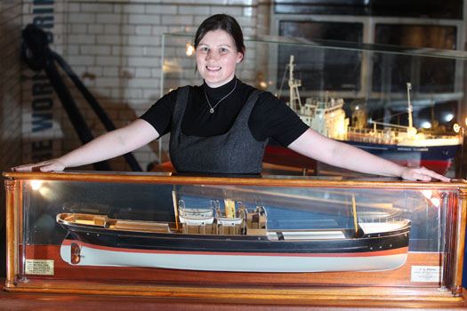
Photo_3_Guinness_Archivist_Eibhlin_Roche_with_model_of_WM_Barkley

Eibhlin Roche - Guinness Archivist, Guinness Storehouse with the model of the W.M. Barkley. Photo: Jason Clarke Photography

Ninety four years ago on the dark night of October 12th 1917 the W.M.Barkley was torpedoed without warning by the German submarine UC-75. Within minutes the ship, which was owned and operated by the Guinness Company of Dublin, broke in two and sank, taking with her to the bottom four men including her Captain and leaving the rest of her crew to face the sea in an open lifeboat. Now, the darkness where the ship has lain in pieces has been disturbed, probed by fingers of sound that are mapping the seabed in incredible details and bringing to light the position of this famous Irish shipwreck.

"As the first Guinness owned ship, the W.M. Barkley played an important role in the story of the transportation of GUINNESS beer overseas," said Eibhlin Roche, Guinness Archivist. The events of the night of 12th October 1917 are very much part of the history of Guinness that is recorded in the Guinness Archive. It is exciting to finally know the exact resting place of the W.M. Barkley."

A scale model of the W.M. Barkley is on display in the Transport Gallery of Guinness Storehouse remembering the lives of the Guinness men who both perished and survived the events of 12th October 1917. These are stories of tragedy and bravery portraying Irish traditional values, and how they were brought to light with the application of cutting-edge technology.
Koen_Verbruggen_Minister_Rabbitte_Dr_Peter_Heffernan_Eibhlin_Roche_and_David_Smith

Koen Verbruggen (GSI), Minister Pat Rabbitte, Dr. Peter Heffernan (CEO, Marine Institute), Eibhlin Roche (Guinness Archivist, Guinness Storehouse) and David Smith (Country Director, Diageo Ireland) Photo: Jason Clarke Photography


Published in Marine Science

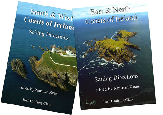
The Irish Cruising Club's acclaimed Sailing Directions, in two volumes, offer comprehensive coverage of the entire coast of Ireland, and their price has recently been reduced by £10.00 to £27.50 each (€32.50).
These are the only cruising guides for the Irish coast to be frequently and comprehensively updated, with corrections available free at www.irishcruisingclub.com.
The 310 page South and West volume was reviewed in Cruising magazine, Sept 2010: "If you are intending to cruise these coasts, or even if you are only thinking of doing so, it is essential. As Sailing Directions they are well-nigh perfect."
Written, edited, designed and printed on the island of Ireland, these handsome hardback books are carried as an aid to navigation and pilotage by the Irish Naval Service, the Irish Coast Guard and the Commissioners of Irish Lights, and they are used as a reference source by the UK Hydrographic Office.
ICC_both_SDs

ICC SDs are available from chandlers and booksellers, and are distributed in Great Britain and the rest of the world by Imray, and in Ireland by Todd Chart Services. East and North Coasts Directions ISBN 978 0 9558 199 1 9; South and West Coasts Directions ISBN 978 0 9558 199 2 6.

Published in Cruising

The Irish Coast Guard

The Irish Coast Guard is Ireland's fourth 'Blue Light' service (along with An Garda Síochána, the Ambulance Service and the Fire Service). It provides a nationwide maritime emergency organisation as well as a variety of services to shipping and other government agencies.

The purpose of the Irish Coast Guard is to promote safety and security standards, and by doing so, prevent as far as possible, the loss of life at sea, and on inland waters, mountains and caves, and to provide effective emergency response services and to safeguard the quality of the marine environment.

The Irish Coast Guard has responsibility for Ireland's system of marine communications, surveillance and emergency management in Ireland's Exclusive Economic Zone (EEZ) and certain inland waterways.

It is responsible for the response to, and co-ordination of, maritime accidents which require search and rescue and counter-pollution and ship casualty operations. It also has responsibility for vessel traffic monitoring.

Operations in respect of maritime security, illegal drug trafficking, illegal migration and fisheries enforcement are co-ordinated by other bodies within the Irish Government.

On average, each year, the Irish Coast Guard is expected to:

  • handle 3,000 marine emergencies
  • assist 4,500 people and save about 200 lives
  • task Coast Guard helicopters on missions

The Coast Guard has been around in some form in Ireland since 1908.

Coast Guard helicopters

The Irish Coast Guard has contracted five medium-lift Sikorsky Search and Rescue helicopters deployed at bases in Dublin, Waterford, Shannon and Sligo.

The helicopters are designated wheels up from initial notification in 15 minutes during daylight hours and 45 minutes at night. One aircraft is fitted and its crew trained for under slung cargo operations up to 3000kgs and is available on short notice based at Waterford.

These aircraft respond to emergencies at sea, inland waterways, offshore islands and mountains of Ireland (32 counties).

They can also be used for assistance in flooding, major inland emergencies, intra-hospital transfers, pollution, and aerial surveillance during daylight hours, lifting and passenger operations and other operations as authorised by the Coast Guard within appropriate regulations.

Irish Coastguard FAQs

The Irish Coast Guard provides nationwide maritime emergency response, while also promoting safety and security standards. It aims to prevent the loss of life at sea, on inland waters, on mountains and in caves; and to safeguard the quality of the marine environment.

The main role of the Irish Coast Guard is to rescue people from danger at sea or on land, to organise immediate medical transport and to assist boats and ships within the country's jurisdiction. It has three marine rescue centres in Dublin, Malin Head, Co Donegal, and Valentia Island, Co Kerry. The Dublin National Maritime Operations centre provides marine search and rescue responses and coordinates the response to marine casualty incidents with the Irish exclusive economic zone (EEZ).

Yes, effectively, it is the fourth "blue light" service. The Marine Rescue Sub-Centre (MRSC) Valentia is the contact point for the coastal area between Ballycotton, Co Cork and Clifden, Co Galway. At the same time, the MRSC Malin Head covers the area between Clifden and Lough Foyle. Marine Rescue Co-ordination Centre (MRCC) Dublin covers Carlingford Lough, Co Louth to Ballycotton, Co Cork. Each MRCC/MRSC also broadcasts maritime safety information on VHF and MF radio, including navigational and gale warnings, shipping forecasts, local inshore forecasts, strong wind warnings and small craft warnings.

The Irish Coast Guard handles about 3,000 marine emergencies annually, and assists 4,500 people - saving an estimated 200 lives, according to the Department of Transport. In 2016, Irish Coast Guard helicopters completed 1,000 missions in a single year for the first time.

Yes, Irish Coast Guard helicopters evacuate medical patients from offshore islands to hospital on average about 100 times a year. In September 2017, the Department of Health announced that search and rescue pilots who work 24-hour duties would not be expected to perform any inter-hospital patient transfers. The Air Corps flies the Emergency Aeromedical Service, established in 2012 and using an AW139 twin-engine helicopter. Known by its call sign "Air Corps 112", it airlifted its 3,000th patient in autumn 2020.

The Irish Coast Guard works closely with the British Maritime and Coastguard Agency, which is responsible for the Northern Irish coast.

The Irish Coast Guard is a State-funded service, with both paid management personnel and volunteers, and is under the auspices of the Department of Transport, Tourism and Sport. It is allocated approximately 74 million euro annually in funding, some 85 per cent of which pays for a helicopter contract that costs 60 million euro annually. The overall funding figure is "variable", an Oireachtas committee was told in 2019. Other significant expenditure items include volunteer training exercises, equipment, maintenance, renewal, and information technology.

The Irish Coast Guard has four search and rescue helicopter bases at Dublin, Waterford, Shannon and Sligo, run on a contract worth 50 million euro annually with an additional 10 million euro in costs by CHC Ireland. It provides five medium-lift Sikorsky S-92 helicopters and trained crew. The 44 Irish Coast Guard coastal units with 1,000 volunteers are classed as onshore search units, with 23 of the 44 units having rigid inflatable boats (RIBs) and 17 units having cliff rescue capability. The Irish Coast Guard has 60 buildings in total around the coast, and units have search vehicles fitted with blue lights, all-terrain vehicles or quads, first aid equipment, generators and area lighting, search equipment, marine radios, pyrotechnics and appropriate personal protective equipment (PPE). The Royal National Lifeboat Institution (RNLI) and Community Rescue Boats Ireland also provide lifeboats and crews to assist in search and rescue. The Irish Coast Guard works closely with the Garda Siochána, National Ambulance Service, Naval Service and Air Corps, Civil Defence, while fishing vessels, ships and other craft at sea offer assistance in search operations.

The helicopters are designated as airborne from initial notification in 15 minutes during daylight hours, and 45 minutes at night. The aircraft respond to emergencies at sea, on inland waterways, offshore islands and mountains and cover the 32 counties. They can also assist in flooding, major inland emergencies, intra-hospital transfers, pollution, and can transport offshore firefighters and ambulance teams. The Irish Coast Guard volunteers units are expected to achieve a 90 per cent response time of departing from the station house in ten minutes from notification during daylight and 20 minutes at night. They are also expected to achieve a 90 per cent response time to the scene of the incident in less than 60 minutes from notification by day and 75 minutes at night, subject to geographical limitations.

Units are managed by an officer-in-charge (three stripes on the uniform) and a deputy officer in charge (two stripes). Each team is trained in search skills, first aid, setting up helicopter landing sites and a range of maritime skills, while certain units are also trained in cliff rescue.

Volunteers receive an allowance for time spent on exercises and call-outs. What is the difference between the Irish Coast Guard and the RNLI? The RNLI is a registered charity which has been saving lives at sea since 1824, and runs a 24/7 volunteer lifeboat service around the British and Irish coasts. It is a declared asset of the British Maritime and Coast Guard Agency and the Irish Coast Guard. Community Rescue Boats Ireland is a community rescue network of volunteers under the auspices of Water Safety Ireland.

No, it does not charge for rescue and nor do the RNLI or Community Rescue Boats Ireland.

The marine rescue centres maintain 19 VHF voice and DSC radio sites around the Irish coastline and a digital paging system. There are two VHF repeater test sites, four MF radio sites and two NAVTEX transmitter sites. Does Ireland have a national search and rescue plan? The first national search and rescue plan was published in July, 2019. It establishes the national framework for the overall development, deployment and improvement of search and rescue services within the Irish Search and Rescue Region and to meet domestic and international commitments. The purpose of the national search and rescue plan is to promote a planned and nationally coordinated search and rescue response to persons in distress at sea, in the air or on land.

Yes, the Irish Coast Guard is responsible for responding to spills of oil and other hazardous substances with the Irish pollution responsibility zone, along with providing an effective response to marine casualties and monitoring or intervening in marine salvage operations. It provides and maintains a 24-hour marine pollution notification at the three marine rescue centres. It coordinates exercises and tests of national and local pollution response plans.

The first Irish Coast Guard volunteer to die on duty was Caitriona Lucas, a highly trained member of the Doolin Coast Guard unit, while assisting in a search for a missing man by the Kilkee unit in September 2016. Six months later, four Irish Coast Guard helicopter crew – Dara Fitzpatrick, Mark Duffy, Paul Ormsby and Ciarán Smith -died when their Sikorsky S-92 struck Blackrock island off the Mayo coast on March 14, 2017. The Dublin-based Rescue 116 crew were providing "top cover" or communications for a medical emergency off the west coast and had been approaching Blacksod to refuel. Up until the five fatalities, the Irish Coast Guard recorded that more than a million "man hours" had been spent on more than 30,000 rescue missions since 1991.

Several investigations were initiated into each incident. The Marine Casualty Investigation Board was critical of the Irish Coast Guard in its final report into the death of Caitriona Lucas, while a separate Health and Safety Authority investigation has been completed, but not published. The Air Accident Investigation Unit final report into the Rescue 116 helicopter crash has not yet been published.

The Irish Coast Guard in its present form dates back to 1991, when the Irish Marine Emergency Service was formed after a campaign initiated by Dr Joan McGinley to improve air/sea rescue services on the west Irish coast. Before Irish independence, the British Admiralty was responsible for a Coast Guard (formerly the Water Guard or Preventative Boat Service) dating back to 1809. The West Coast Search and Rescue Action Committee was initiated with a public meeting in Killybegs, Co Donegal, in 1988 and the group was so effective that a Government report was commissioned, which recommended setting up a new division of the Department of the Marine to run the Marine Rescue Co-Ordination Centre (MRCC), then based at Shannon, along with the existing coast radio service, and coast and cliff rescue. A medium-range helicopter base was established at Shannon within two years. Initially, the base was served by the Air Corps.

The first director of what was then IMES was Capt Liam Kirwan, who had spent 20 years at sea and latterly worked with the Marine Survey Office. Capt Kirwan transformed a poorly funded voluntary coast and cliff rescue service into a trained network of cliff and sea rescue units – largely voluntary, but with paid management. The MRCC was relocated from Shannon to an IMES headquarters at the then Department of the Marine (now Department of Transport) in Leeson Lane, Dublin. The coast radio stations at Valentia, Co Kerry, and Malin Head, Co Donegal, became marine rescue-sub-centres.

The current director is Chris Reynolds, who has been in place since August 2007 and was formerly with the Naval Service. He has been seconded to the head of mission with the EUCAP Somalia - which has a mandate to enhance Somalia's maritime civilian law enforcement capacity – since January 2019.

  • Achill, Co. Mayo
  • Ardmore, Co. Waterford
  • Arklow, Co. Wicklow
  • Ballybunion, Co. Kerry
  • Ballycotton, Co. Cork
  • Ballyglass, Co. Mayo
  • Bonmahon, Co. Waterford
  • Bunbeg, Co. Donegal
  • Carnsore, Co. Wexford
  • Castlefreake, Co. Cork
  • Castletownbere, Co. Cork
  • Cleggan, Co. Galway
  • Clogherhead, Co. Louth
  • Costelloe Bay, Co. Galway
  • Courtown, Co. Wexford
  • Crosshaven, Co. Cork
  • Curracloe, Co. Wexford
  • Dingle, Co. Kerry
  • Doolin, Co. Clare
  • Drogheda, Co. Louth
  • Dun Laoghaire, Co. Dublin
  • Dunmore East, Co. Waterford
  • Fethard, Co. Wexford
  • Glandore, Co. Cork
  • Glenderry, Co. Kerry
  • Goleen, Co. Cork
  • Greencastle, Co. Donegal
  • Greenore, Co. Louth
  • Greystones, Co. Wicklow
  • Guileen, Co. Cork
  • Howth, Co. Dublin
  • Kilkee, Co. Clare
  • Killala, Co. Mayo
  • Killybegs, Co. Donegal
  • Kilmore Quay, Co. Wexford
  • Knightstown, Co. Kerry
  • Mulroy, Co. Donegal
  • North Aran, Co. Galway
  • Old Head Of Kinsale, Co. Cork
  • Oysterhaven, Co. Cork
  • Rosslare, Co. Wexford
  • Seven Heads, Co. Cork
  • Skerries, Co. Dublin Summercove, Co. Cork
  • Toe Head, Co. Cork
  • Tory Island, Co. Donegal
  • Tramore, Co. Waterford
  • Waterville, Co. Kerry
  • Westport, Co. Mayo
  • Wicklow
  • Youghal, Co. Cork

Sources: Department of Transport © Afloat 2020