Menu

Ireland's sailing, boating & maritime magazine

Displaying items by tag: Irish Weather Buoy Network

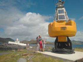
#Buoys - After more than two decades of service as part of the Marine Institute’s national weather buoy network, the affectionately named ‘Bob the Buoy’ will see out his retirement as a permanent resident at Valentia Lighthouse.

Bob withstood countless storms over the years, reporting hourly weather observations to Met Éireann and European partners.

Now visitors to Valentia Island in Co Kerry can check out Bob’s new home at Cromwell Point and get a closer insight into Ireland’s marine navigation and safeguarding history.

“Weather buoys are a fundamental aspect of our maritime history, and it is our hope that Bob will emphasise this in his new location here, on Valentia, the most extreme south-westerly point of Europe,” said Paul Duff, member of the lighthouse committee which worked closely with the Marine Institute on the buoy’s relocation.

“It is fitting that he should be placed here, and we look forward to incorporating him into our visitor experience,” Duff added.

Lighthouse committee chair Brian Morgan said: “This is such a fantastic artefact. It is our hope that we can reinstate Bob, a working retirement if you like, in order for us to provide a weather feed which we can share through our community, and lighthouse network, utilising the available technology, but we will let him settle in first.”

Dr Guy Westbrook from the Marine Institute said he and his colleagues are delighted that Bob has a new home at Valentia to educate the public about the weather buoy network.

“Designed to improve weather forecasts and safety at sea around Ireland, the buoy network provides vital data for weather forecasts, shipping bulletins, gale and swell warnings as well as data for general public information and research,” Dr Westbrook added.

In other news, the large marker buoy found adrift by Clifden RNLI in late July has been removed from the Connemara coast.

Harry Duggan of the Commissioners of Irish Lights says the buoy, which originated in Canadian waters, was as of yesterday (Friday 10 August) on its way to CIL headquarters in Dun Laoghaire.

The CIL recommends caution around any and all aids to navigation around the Irish coast.

Published in Marine Science

#Weather - The work of the Marine Institute's Irish Weather Buoy Network will feature on RTE One's Weather Live this evening (Friday 17 November).

The TV programme has filmed the redeployment of the M5 weather buoy, which broke free during Storm Ophelia. The show will also feature an interview with the Marine Institute's Dr Guy Westbrook.

A weather buoy has been transported to the Botanic Gardens in Dublin, where Weather Live broadcasts live, so those tuning in can see what one looks like.

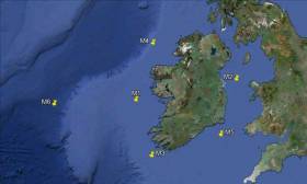
The Irish Weather Buoy Network delivers data every hour that is then fed into a global information network which includes Met Éireann, the Irish Meterological Service. This data is then used to inform forecasts as well as long-term information gathering.

Located off the South East coast, the M5 weather buoy captured two records during Ophelia: a record individual wave (Hmax) of 17.81m and a record significant wave height (Hs) of 12.97m.

During the storm, the raging seas caused the M5 mooring to break and the buoy needed to be recovered to shore when the seas had calmed.

Due to the relative importance to forecasters of the M5 weather observing location, it was decided to deploy the M4 target system that had been on test in Killybegs at M5.

This buoy was disassembled and transported by road to Cobh dockyard where it was loaded onto the ILV Granuaile and prepared for subsequent deployment.

Marine Institute staff embarked the vessel on 1 November and deployment of the buoy took place the next day in exceptionally calm conditions.

Weather Live is a three-day television event on RTÉ One that focuses on the fascinating world of weather. It’s presented by Kathryn Thomas and features meteorologists including Evelyn Cusack, Gerald Fleming and Gerry Murphy, and coincides with events for Science Week 2017, as previously reported on Afloat.ie.

The third and final broadcast of the series goes out live this evening Friday 17 November at 7pm on RTE One.

Published in Weather

Record wave heights were captured by the Irish Weather Buoy Network during Hurricane Ophelia on Monday 16th October, causing one of the five weather buoys to break it moorings.

The highest wave was recorded off the Irish coastline at 16.00 on Monday when the M5 weather buoy off the South East coast, measured a record individual wave (Hmax) of 17.81m* and a record significant wave height (Hs) of 12.97m **.

The M5 weather buoy subsequently broke away from its mooring and the Marine Institute coordinated the retrieval process as a matter of urgency. The M5 was recovered yesterday by the MV Puffin of Fastnet Shipping (Waterford) and brought ashore last night.

As Ophelia moved northwards, the M2 buoy to the east of Dublin also experienced a record significant wave height (HS )** of 6.64m measured at 18.00 on Monday 16th.

baltimore beaconWaves lash the Baltimore beacon in West Cork during Storm Ophelia. Photo: Youen Jacob
Earlier in the day, at 12.00, the M3 buoy, off the South West coast measured an individual wave height of 13.59m, although this was not a record wave for this buoy.

In addition to measuring the waves, the weather buoy network, which is managed by the Marine Institute provides further vital atmospheric (including wind speed) and oceanographic information to support both maritime safety and, importantly in storm events such as Ophelia, help to validate the weather forecast models run by Met Éireann providing guidance to the national emergency planning efforts.

The Irish Weather Buoy Network is designed to improve weather forecasts and safety at sea around Ireland. The buoy network also provides operational ocean models, shipping bulletins, gale and swell warnings as well as data for general public information and research. The network is managed by the Marine Institute in collaboration with Met Éireann, the UK Met Office and the Irish Department of Transport, Tourism and Sport (DTTAS). Real time data from the network can be found here.

Published in Marine Science

The Irish Coast Guard

The Irish Coast Guard is Ireland's fourth 'Blue Light' service (along with An Garda Síochána, the Ambulance Service and the Fire Service). It provides a nationwide maritime emergency organisation as well as a variety of services to shipping and other government agencies.

The purpose of the Irish Coast Guard is to promote safety and security standards, and by doing so, prevent as far as possible, the loss of life at sea, and on inland waters, mountains and caves, and to provide effective emergency response services and to safeguard the quality of the marine environment.

The Irish Coast Guard has responsibility for Ireland's system of marine communications, surveillance and emergency management in Ireland's Exclusive Economic Zone (EEZ) and certain inland waterways.

It is responsible for the response to, and co-ordination of, maritime accidents which require search and rescue and counter-pollution and ship casualty operations. It also has responsibility for vessel traffic monitoring.

Operations in respect of maritime security, illegal drug trafficking, illegal migration and fisheries enforcement are co-ordinated by other bodies within the Irish Government.

On average, each year, the Irish Coast Guard is expected to:

  • handle 3,000 marine emergencies
  • assist 4,500 people and save about 200 lives
  • task Coast Guard helicopters on missions

The Coast Guard has been around in some form in Ireland since 1908.

Coast Guard helicopters

The Irish Coast Guard has contracted five medium-lift Sikorsky Search and Rescue helicopters deployed at bases in Dublin, Waterford, Shannon and Sligo.

The helicopters are designated wheels up from initial notification in 15 minutes during daylight hours and 45 minutes at night. One aircraft is fitted and its crew trained for under slung cargo operations up to 3000kgs and is available on short notice based at Waterford.

These aircraft respond to emergencies at sea, inland waterways, offshore islands and mountains of Ireland (32 counties).

They can also be used for assistance in flooding, major inland emergencies, intra-hospital transfers, pollution, and aerial surveillance during daylight hours, lifting and passenger operations and other operations as authorised by the Coast Guard within appropriate regulations.

Irish Coastguard FAQs

The Irish Coast Guard provides nationwide maritime emergency response, while also promoting safety and security standards. It aims to prevent the loss of life at sea, on inland waters, on mountains and in caves; and to safeguard the quality of the marine environment.

The main role of the Irish Coast Guard is to rescue people from danger at sea or on land, to organise immediate medical transport and to assist boats and ships within the country's jurisdiction. It has three marine rescue centres in Dublin, Malin Head, Co Donegal, and Valentia Island, Co Kerry. The Dublin National Maritime Operations centre provides marine search and rescue responses and coordinates the response to marine casualty incidents with the Irish exclusive economic zone (EEZ).

Yes, effectively, it is the fourth "blue light" service. The Marine Rescue Sub-Centre (MRSC) Valentia is the contact point for the coastal area between Ballycotton, Co Cork and Clifden, Co Galway. At the same time, the MRSC Malin Head covers the area between Clifden and Lough Foyle. Marine Rescue Co-ordination Centre (MRCC) Dublin covers Carlingford Lough, Co Louth to Ballycotton, Co Cork. Each MRCC/MRSC also broadcasts maritime safety information on VHF and MF radio, including navigational and gale warnings, shipping forecasts, local inshore forecasts, strong wind warnings and small craft warnings.

The Irish Coast Guard handles about 3,000 marine emergencies annually, and assists 4,500 people - saving an estimated 200 lives, according to the Department of Transport. In 2016, Irish Coast Guard helicopters completed 1,000 missions in a single year for the first time.

Yes, Irish Coast Guard helicopters evacuate medical patients from offshore islands to hospital on average about 100 times a year. In September 2017, the Department of Health announced that search and rescue pilots who work 24-hour duties would not be expected to perform any inter-hospital patient transfers. The Air Corps flies the Emergency Aeromedical Service, established in 2012 and using an AW139 twin-engine helicopter. Known by its call sign "Air Corps 112", it airlifted its 3,000th patient in autumn 2020.

The Irish Coast Guard works closely with the British Maritime and Coastguard Agency, which is responsible for the Northern Irish coast.

The Irish Coast Guard is a State-funded service, with both paid management personnel and volunteers, and is under the auspices of the Department of Transport, Tourism and Sport. It is allocated approximately 74 million euro annually in funding, some 85 per cent of which pays for a helicopter contract that costs 60 million euro annually. The overall funding figure is "variable", an Oireachtas committee was told in 2019. Other significant expenditure items include volunteer training exercises, equipment, maintenance, renewal, and information technology.

The Irish Coast Guard has four search and rescue helicopter bases at Dublin, Waterford, Shannon and Sligo, run on a contract worth 50 million euro annually with an additional 10 million euro in costs by CHC Ireland. It provides five medium-lift Sikorsky S-92 helicopters and trained crew. The 44 Irish Coast Guard coastal units with 1,000 volunteers are classed as onshore search units, with 23 of the 44 units having rigid inflatable boats (RIBs) and 17 units having cliff rescue capability. The Irish Coast Guard has 60 buildings in total around the coast, and units have search vehicles fitted with blue lights, all-terrain vehicles or quads, first aid equipment, generators and area lighting, search equipment, marine radios, pyrotechnics and appropriate personal protective equipment (PPE). The Royal National Lifeboat Institution (RNLI) and Community Rescue Boats Ireland also provide lifeboats and crews to assist in search and rescue. The Irish Coast Guard works closely with the Garda Siochána, National Ambulance Service, Naval Service and Air Corps, Civil Defence, while fishing vessels, ships and other craft at sea offer assistance in search operations.

The helicopters are designated as airborne from initial notification in 15 minutes during daylight hours, and 45 minutes at night. The aircraft respond to emergencies at sea, on inland waterways, offshore islands and mountains and cover the 32 counties. They can also assist in flooding, major inland emergencies, intra-hospital transfers, pollution, and can transport offshore firefighters and ambulance teams. The Irish Coast Guard volunteers units are expected to achieve a 90 per cent response time of departing from the station house in ten minutes from notification during daylight and 20 minutes at night. They are also expected to achieve a 90 per cent response time to the scene of the incident in less than 60 minutes from notification by day and 75 minutes at night, subject to geographical limitations.

Units are managed by an officer-in-charge (three stripes on the uniform) and a deputy officer in charge (two stripes). Each team is trained in search skills, first aid, setting up helicopter landing sites and a range of maritime skills, while certain units are also trained in cliff rescue.

Volunteers receive an allowance for time spent on exercises and call-outs. What is the difference between the Irish Coast Guard and the RNLI? The RNLI is a registered charity which has been saving lives at sea since 1824, and runs a 24/7 volunteer lifeboat service around the British and Irish coasts. It is a declared asset of the British Maritime and Coast Guard Agency and the Irish Coast Guard. Community Rescue Boats Ireland is a community rescue network of volunteers under the auspices of Water Safety Ireland.

No, it does not charge for rescue and nor do the RNLI or Community Rescue Boats Ireland.

The marine rescue centres maintain 19 VHF voice and DSC radio sites around the Irish coastline and a digital paging system. There are two VHF repeater test sites, four MF radio sites and two NAVTEX transmitter sites. Does Ireland have a national search and rescue plan? The first national search and rescue plan was published in July, 2019. It establishes the national framework for the overall development, deployment and improvement of search and rescue services within the Irish Search and Rescue Region and to meet domestic and international commitments. The purpose of the national search and rescue plan is to promote a planned and nationally coordinated search and rescue response to persons in distress at sea, in the air or on land.

Yes, the Irish Coast Guard is responsible for responding to spills of oil and other hazardous substances with the Irish pollution responsibility zone, along with providing an effective response to marine casualties and monitoring or intervening in marine salvage operations. It provides and maintains a 24-hour marine pollution notification at the three marine rescue centres. It coordinates exercises and tests of national and local pollution response plans.

The first Irish Coast Guard volunteer to die on duty was Caitriona Lucas, a highly trained member of the Doolin Coast Guard unit, while assisting in a search for a missing man by the Kilkee unit in September 2016. Six months later, four Irish Coast Guard helicopter crew – Dara Fitzpatrick, Mark Duffy, Paul Ormsby and Ciarán Smith -died when their Sikorsky S-92 struck Blackrock island off the Mayo coast on March 14, 2017. The Dublin-based Rescue 116 crew were providing "top cover" or communications for a medical emergency off the west coast and had been approaching Blacksod to refuel. Up until the five fatalities, the Irish Coast Guard recorded that more than a million "man hours" had been spent on more than 30,000 rescue missions since 1991.

Several investigations were initiated into each incident. The Marine Casualty Investigation Board was critical of the Irish Coast Guard in its final report into the death of Caitriona Lucas, while a separate Health and Safety Authority investigation has been completed, but not published. The Air Accident Investigation Unit final report into the Rescue 116 helicopter crash has not yet been published.

The Irish Coast Guard in its present form dates back to 1991, when the Irish Marine Emergency Service was formed after a campaign initiated by Dr Joan McGinley to improve air/sea rescue services on the west Irish coast. Before Irish independence, the British Admiralty was responsible for a Coast Guard (formerly the Water Guard or Preventative Boat Service) dating back to 1809. The West Coast Search and Rescue Action Committee was initiated with a public meeting in Killybegs, Co Donegal, in 1988 and the group was so effective that a Government report was commissioned, which recommended setting up a new division of the Department of the Marine to run the Marine Rescue Co-Ordination Centre (MRCC), then based at Shannon, along with the existing coast radio service, and coast and cliff rescue. A medium-range helicopter base was established at Shannon within two years. Initially, the base was served by the Air Corps.

The first director of what was then IMES was Capt Liam Kirwan, who had spent 20 years at sea and latterly worked with the Marine Survey Office. Capt Kirwan transformed a poorly funded voluntary coast and cliff rescue service into a trained network of cliff and sea rescue units – largely voluntary, but with paid management. The MRCC was relocated from Shannon to an IMES headquarters at the then Department of the Marine (now Department of Transport) in Leeson Lane, Dublin. The coast radio stations at Valentia, Co Kerry, and Malin Head, Co Donegal, became marine rescue-sub-centres.

The current director is Chris Reynolds, who has been in place since August 2007 and was formerly with the Naval Service. He has been seconded to the head of mission with the EUCAP Somalia - which has a mandate to enhance Somalia's maritime civilian law enforcement capacity – since January 2019.

  • Achill, Co. Mayo
  • Ardmore, Co. Waterford
  • Arklow, Co. Wicklow
  • Ballybunion, Co. Kerry
  • Ballycotton, Co. Cork
  • Ballyglass, Co. Mayo
  • Bonmahon, Co. Waterford
  • Bunbeg, Co. Donegal
  • Carnsore, Co. Wexford
  • Castlefreake, Co. Cork
  • Castletownbere, Co. Cork
  • Cleggan, Co. Galway
  • Clogherhead, Co. Louth
  • Costelloe Bay, Co. Galway
  • Courtown, Co. Wexford
  • Crosshaven, Co. Cork
  • Curracloe, Co. Wexford
  • Dingle, Co. Kerry
  • Doolin, Co. Clare
  • Drogheda, Co. Louth
  • Dun Laoghaire, Co. Dublin
  • Dunmore East, Co. Waterford
  • Fethard, Co. Wexford
  • Glandore, Co. Cork
  • Glenderry, Co. Kerry
  • Goleen, Co. Cork
  • Greencastle, Co. Donegal
  • Greenore, Co. Louth
  • Greystones, Co. Wicklow
  • Guileen, Co. Cork
  • Howth, Co. Dublin
  • Kilkee, Co. Clare
  • Killala, Co. Mayo
  • Killybegs, Co. Donegal
  • Kilmore Quay, Co. Wexford
  • Knightstown, Co. Kerry
  • Mulroy, Co. Donegal
  • North Aran, Co. Galway
  • Old Head Of Kinsale, Co. Cork
  • Oysterhaven, Co. Cork
  • Rosslare, Co. Wexford
  • Seven Heads, Co. Cork
  • Skerries, Co. Dublin Summercove, Co. Cork
  • Toe Head, Co. Cork
  • Tory Island, Co. Donegal
  • Tramore, Co. Waterford
  • Waterville, Co. Kerry
  • Westport, Co. Mayo
  • Wicklow
  • Youghal, Co. Cork

Sources: Department of Transport © Afloat 2020