Menu

Ireland's sailing, boating & maritime magazine

Displaying items by tag: Marine Notice
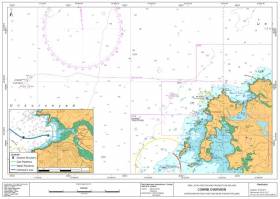
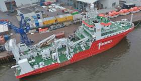
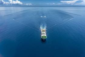
#MarineNotice - Nexen Petroleum Ltd advises that it will conduct a 2D seismic survey in the Southern Porcupine Basin off the South West Coast of Ireland this week.

The survey will commence on Wednesday 12 July and will last approximately six operational days, depending on weather conditions. 

The aim of the proposed ‘Iolar’ geophysical survey is to accurately determine water depths, the nature of the seabed material and, locate and identify any seabed and sub-seabed features. 

The vessel involved will be the M/V Fugro Venturer (Callsign C6CG3).

Full details of the survey area are included in Marine Notice No 30 of 2017, a PDF of which is available to read or download HERE.

As reported earlier today on Afloat.ie, another seismic survey is scheduled to begin this week some 210nm off Bull Rock.

Providence Resources is also currently drilling an exploration well at its prospect in the Southern Porcupine Basin.

Published in News Update

#MarineNotice - Mullock & Sons (Shipbrokers) Ltd advises that a seismic survey is being conducted some 210 nautical miles west-southwest of Bull Rock Lighthouse off West Cork.

Operations are scheduled to begin tomorrow (Tuesday 11 July) with provision to start earlier on Friday 7 or Saturday 8 July, and will last three months, weather dependant.

The vessels involved will be the seismic vessel Polar Marquis (Callsign LAOI5), which is towing a spread of 12 x 8100m cables with a width of 1,540m just below the surface. 

The support vessel is the Moonrise GSL (Callsign HPEW) and the guard vessel is the Ary (Callsign YJQJ5).

There will be radio transmissions to vessels in the vicinity, with warnings broadcast on VHF Channel 16. Tail buoys will be used on the end of each streamer; they are yellow in colour and are equipped with strobing lights and radar reflectors.

At the end of each survey line, the vessel requires an area to turn around; this is some 15km in addition to the area confined within the coordinates given.

Full details of the survey area are included in Marine Notice No 29 of 2017, a PDF of which is available to read or download HERE.

Published in News Update

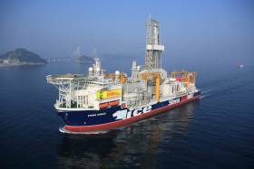
#MarineNotice - Providence Resources advises it intends to drill an exploration well in the Southern Porcupine Basin.

Operations were scheduled to begin today (Monday 3 July) to drill the well at a depth of 2,250 metres some 220km off the South West Coast of Ireland.

Drilling is expected to take 60 days to complete, subject to weather and operational delays.

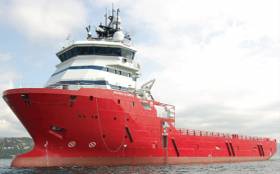
The dynamically positioned drill ship Stena IceMax (Callsign 2FMJ5) will carry out the drilling, supported by platform supply vessels Sjoborg (Callsign OZ-2075), Edda Frende (Callsign LCOB) and Skandi Flora (Callsign LEVX). The emergency rapid response vessel is Esvagt Don (Callsign MZWQ6).

There will be a safety exclusion zone of 500m radius from the drill ship. Regular safety messages will be broadcast on VHF Channel 16 by Esvagt Don throughout the project. Radio navigation warnings will also be issued several times daily by the Irish Coast Guard

All vessels, particularly those engaged in fishing, are requested to give the Stena IceMax and accompanying vessels a wide berth and keep a sharp lookout in the relevant areas.

Full details of the drilling area are included in Marine Notice No 28 of 2017, a PDF of which is available to read or download HERE.

Published in News Update

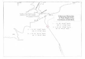
#MarineWarning - PSE Kinsale Energy Ltd advises that, that following a recent survey of the Kinsale Head Gas Field pipeline, it has identified a possible seabed obstruction off the South Coast of Ireland.

The nature of the obstruction, south-east of Roches Point on the approach to Cork Harbour, may present a hazard to ground fishing equipment, so any fishing vessels operating within the area are advised to proceed with caution.

Details of co-ordinates of the affected area are included in Marine Notice No 26 of 2017, a PDF of which is available to read or download HERE.

Published in Marine Warning

#MarineNotice - Shell E&P Ireland advises that inspection and engineering tasks will take place at the Corrib Gas Field and related offshore infrastructure from this month.

The work, due to commence in mid June and last for around 40 days, will include inspection of the offshore pipeline and subsea structure, inspection of the near shore pipeline, an umbilical lay at well P5, and a pipeline integrity test via ‘intelligent pig’ survey.

Visual and acoustic surveys will be conducted by means of vessel- and ROV-mounted sensors and cameras located on attendant survey vessels, ROVs and towed side scan sonar.

The Subsea Viking (callsign LJJL3) will undertake the deep water surveys and the subsea facilities maintenance and inspection. It will also carry out the umbilical lay and the intelligent pigging operation. All equipment used will be vessel and/or ROV mounted.

The An Gearoidin (callsign EIDL6) will undertake the inshore survey scope. All the equipment used will be vessel deployed.

Both vessels will be listening on VHF Channel 16 throughout the project.

Full details of the survey areas are included in Marine Notice No 25 of 2017, a PDF of which is available to read or download HERE.

Published in News Update

#MarineNotice - The Department of Transport, Tourism and Sport has posted its schedule of examination dates for Certificates of Competency for Deck Officers, Marine Engineer Officers, Skippers and Second Hands for the year commencing 1 September 2017, as detailed in Marine Notice No 21 of 2017.

Also recently published is a reminder to masters, owners and users of the requirements set out in the Code of Practice for the Design, Construction, Equipment and Operation of Small Fishing Vessels of less than 15m Length overall, with particular reference to the fitting of appropriate non-slip decking.

Marine Notice No 22 of 2017 comes on the foot of recommendations from the Marine Casualty Investigation Board in its report last year into an incident on a lobster boat off Donegal, in which a crewman died after falling overboard.

Finally, the Minister for Transport, Tourism and Sport has made a new Statutory Instrument that gives effect to an EU regulation on procedures for the identification of recreational craft and personal watercraft.

Full details of the new legislation are included in Marine Notice No 23 of 2017, a PDF of which is available to read or download HERE.

Published in News Update
Tagged under

#MarineNotice - Geoscience company CGG’s 3D seismic survey in the Porcupine Basin extends from today (Saturday 20 May) for the next 50 days, weather dependent.

Joining the survey previously reported last month is the Geo Caspian (Callsign 3FCZ6), accompanied by the Bourbon Tern (Callsign 5BDQ4) and the Mariska G (Callsign HO7662).

Yellow tail buoys will be towed at the end of each streamer, around 8.7km (4.7nm) behind the Geo Caspian. Each tail buoy will have a light flashing Morse code ‘U’ with an interval of approximately seven seconds.

Regular safety messaged will be broadcast from the Geo Caspian and its support vessels on VHF Channel 16 throughout the project.

Full details of the survey area are included in Marine Notice No 20 of 2017, a PDF of which is available to read or download HERE.
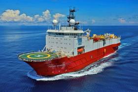
Published in News Update

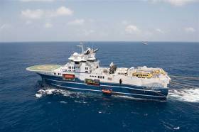
#MarineNotice - Sailors and other mariners off the South West Coast should keep on the lookout for a visual survey by remote operated vehicle currently being undertaken by PSE Kindle Energy Ltd.

The survey, which was set to commence on Tuesday 9 May, will run for the next three weeks in the environs of the Kinsale Head Gas Field, subject to weather conditions, and is being carried out from the Skandi Olympia (Callsign C6XY8).

The vessel will have an ROV deployed close to the seabed and its travel rate (survey rate) is approximately 0.4 knots over the ground on a weather-dependent heading.

Regular safety messages will be broadcast on VHF Channel 16. All vessels, and particularly those engaged in fishing, are requested to give the Skandi Olympia a wide berth and keep a sharp lookout in the revenant areas, as detailed in Marine Notice No 19 of 2017, a PDF of which is available to read or download HERE.

In case of any doubt, call the vessel on VHF and a safe course to follow will be given.

Published in Marine Warning

#MarineNotice - Geoscience company CGG is currently conducting a 3D seismic survey off the South West Coast of Ireland in the Porcupine Basin.

The three-month survey was scheduled to begin on Tuesday 11 April and will continue till Saturday 15 July. The vessels involved will be the Geo Coral (Callsign LACA8), Bourbon Tern (Callsign 5BDQ4), Marianne G (Callsign 3FTA9) and Stormbas 2 (Callsign V4EM2).

The Geo Coral is towing a multi-sensor streamer including 14 streamers with a 100m separation of an 8km length and a depth of 12 metres.

Yellow tail buoys will be towed at the end of each streamer, approximately 8.7km (4.7nm) behind the Geo Coral. Each tail buoy will have a light flashing Morse code 'U' with an interval of approximately 7 seconds.

There will be regular safety message broadcasting on VHF Channel 16 by the Geo Coral and accompanying vessels Marianne G and Stormbas 2 throughout the project. Seismic activity will be protected by support and chase vessels.

All vessels, particularly those engaged in fishing, are requested to give the Geo Coral and the towed equipment a wide berth and keep a sharp lookout in the relevant areas. In case of any doubt, call the Geo Coral on VHF Channel 16 and a safe course to follow will be given.

Full details of co-ordinates for the survey area are included in Marine Notice No 13 of 2017, a PDF of which is available to read or download HERE.

Published in News Update

#Fishing - The Marine Institute will begin the annual Irish Anglerfish and Megrim Survey (IAMS 2017) off the North and North West Coasts from tomorrow (Saturday 8 June).

The 10-day operation, in fulfilment of Ireland’s Common Fisheries Policy (CFP) obligations, is a demersal trawl survey consisting of approximately 49 otter trawls (60 minutes) in ICES area 6a off Donegal – following on from a similar operation off the South Coast last month.

Fishing will take place within a three nautical mile radius of the positions indicated in Marine Notice 18 of 2017, a PDF of which is available to read or download HERE.

The RV Celtic Explorer (Callsign EIGB) will be used throughout the duration of the survey. The vessel will be towing a Jackson demersal trawl during fishing operations, will display appropriate lights and signals, and will be listening on VHF Channel 16 throughout.

Commercial fishing and other marine operators are requested to keep a 3nm area around the tow points clear of any gear or apparatus during the survey period.

Full co-ordinates of the survey area, as well as details for fishing operators with static gear within the survey zone, are included in the aforementioned Marine Notice.

Published in Fishing
Page 34 of 54

The Irish Coast Guard

The Irish Coast Guard is Ireland's fourth 'Blue Light' service (along with An Garda Síochána, the Ambulance Service and the Fire Service). It provides a nationwide maritime emergency organisation as well as a variety of services to shipping and other government agencies.

The purpose of the Irish Coast Guard is to promote safety and security standards, and by doing so, prevent as far as possible, the loss of life at sea, and on inland waters, mountains and caves, and to provide effective emergency response services and to safeguard the quality of the marine environment.

The Irish Coast Guard has responsibility for Ireland's system of marine communications, surveillance and emergency management in Ireland's Exclusive Economic Zone (EEZ) and certain inland waterways.

It is responsible for the response to, and co-ordination of, maritime accidents which require search and rescue and counter-pollution and ship casualty operations. It also has responsibility for vessel traffic monitoring.

Operations in respect of maritime security, illegal drug trafficking, illegal migration and fisheries enforcement are co-ordinated by other bodies within the Irish Government.

On average, each year, the Irish Coast Guard is expected to:

  • handle 3,000 marine emergencies
  • assist 4,500 people and save about 200 lives
  • task Coast Guard helicopters on missions

The Coast Guard has been around in some form in Ireland since 1908.

Coast Guard helicopters

The Irish Coast Guard has contracted five medium-lift Sikorsky Search and Rescue helicopters deployed at bases in Dublin, Waterford, Shannon and Sligo.

The helicopters are designated wheels up from initial notification in 15 minutes during daylight hours and 45 minutes at night. One aircraft is fitted and its crew trained for under slung cargo operations up to 3000kgs and is available on short notice based at Waterford.

These aircraft respond to emergencies at sea, inland waterways, offshore islands and mountains of Ireland (32 counties).

They can also be used for assistance in flooding, major inland emergencies, intra-hospital transfers, pollution, and aerial surveillance during daylight hours, lifting and passenger operations and other operations as authorised by the Coast Guard within appropriate regulations.

Irish Coastguard FAQs

The Irish Coast Guard provides nationwide maritime emergency response, while also promoting safety and security standards. It aims to prevent the loss of life at sea, on inland waters, on mountains and in caves; and to safeguard the quality of the marine environment.

The main role of the Irish Coast Guard is to rescue people from danger at sea or on land, to organise immediate medical transport and to assist boats and ships within the country's jurisdiction. It has three marine rescue centres in Dublin, Malin Head, Co Donegal, and Valentia Island, Co Kerry. The Dublin National Maritime Operations centre provides marine search and rescue responses and coordinates the response to marine casualty incidents with the Irish exclusive economic zone (EEZ).

Yes, effectively, it is the fourth "blue light" service. The Marine Rescue Sub-Centre (MRSC) Valentia is the contact point for the coastal area between Ballycotton, Co Cork and Clifden, Co Galway. At the same time, the MRSC Malin Head covers the area between Clifden and Lough Foyle. Marine Rescue Co-ordination Centre (MRCC) Dublin covers Carlingford Lough, Co Louth to Ballycotton, Co Cork. Each MRCC/MRSC also broadcasts maritime safety information on VHF and MF radio, including navigational and gale warnings, shipping forecasts, local inshore forecasts, strong wind warnings and small craft warnings.

The Irish Coast Guard handles about 3,000 marine emergencies annually, and assists 4,500 people - saving an estimated 200 lives, according to the Department of Transport. In 2016, Irish Coast Guard helicopters completed 1,000 missions in a single year for the first time.

Yes, Irish Coast Guard helicopters evacuate medical patients from offshore islands to hospital on average about 100 times a year. In September 2017, the Department of Health announced that search and rescue pilots who work 24-hour duties would not be expected to perform any inter-hospital patient transfers. The Air Corps flies the Emergency Aeromedical Service, established in 2012 and using an AW139 twin-engine helicopter. Known by its call sign "Air Corps 112", it airlifted its 3,000th patient in autumn 2020.

The Irish Coast Guard works closely with the British Maritime and Coastguard Agency, which is responsible for the Northern Irish coast.

The Irish Coast Guard is a State-funded service, with both paid management personnel and volunteers, and is under the auspices of the Department of Transport, Tourism and Sport. It is allocated approximately 74 million euro annually in funding, some 85 per cent of which pays for a helicopter contract that costs 60 million euro annually. The overall funding figure is "variable", an Oireachtas committee was told in 2019. Other significant expenditure items include volunteer training exercises, equipment, maintenance, renewal, and information technology.

The Irish Coast Guard has four search and rescue helicopter bases at Dublin, Waterford, Shannon and Sligo, run on a contract worth 50 million euro annually with an additional 10 million euro in costs by CHC Ireland. It provides five medium-lift Sikorsky S-92 helicopters and trained crew. The 44 Irish Coast Guard coastal units with 1,000 volunteers are classed as onshore search units, with 23 of the 44 units having rigid inflatable boats (RIBs) and 17 units having cliff rescue capability. The Irish Coast Guard has 60 buildings in total around the coast, and units have search vehicles fitted with blue lights, all-terrain vehicles or quads, first aid equipment, generators and area lighting, search equipment, marine radios, pyrotechnics and appropriate personal protective equipment (PPE). The Royal National Lifeboat Institution (RNLI) and Community Rescue Boats Ireland also provide lifeboats and crews to assist in search and rescue. The Irish Coast Guard works closely with the Garda Siochána, National Ambulance Service, Naval Service and Air Corps, Civil Defence, while fishing vessels, ships and other craft at sea offer assistance in search operations.

The helicopters are designated as airborne from initial notification in 15 minutes during daylight hours, and 45 minutes at night. The aircraft respond to emergencies at sea, on inland waterways, offshore islands and mountains and cover the 32 counties. They can also assist in flooding, major inland emergencies, intra-hospital transfers, pollution, and can transport offshore firefighters and ambulance teams. The Irish Coast Guard volunteers units are expected to achieve a 90 per cent response time of departing from the station house in ten minutes from notification during daylight and 20 minutes at night. They are also expected to achieve a 90 per cent response time to the scene of the incident in less than 60 minutes from notification by day and 75 minutes at night, subject to geographical limitations.

Units are managed by an officer-in-charge (three stripes on the uniform) and a deputy officer in charge (two stripes). Each team is trained in search skills, first aid, setting up helicopter landing sites and a range of maritime skills, while certain units are also trained in cliff rescue.

Volunteers receive an allowance for time spent on exercises and call-outs. What is the difference between the Irish Coast Guard and the RNLI? The RNLI is a registered charity which has been saving lives at sea since 1824, and runs a 24/7 volunteer lifeboat service around the British and Irish coasts. It is a declared asset of the British Maritime and Coast Guard Agency and the Irish Coast Guard. Community Rescue Boats Ireland is a community rescue network of volunteers under the auspices of Water Safety Ireland.

No, it does not charge for rescue and nor do the RNLI or Community Rescue Boats Ireland.

The marine rescue centres maintain 19 VHF voice and DSC radio sites around the Irish coastline and a digital paging system. There are two VHF repeater test sites, four MF radio sites and two NAVTEX transmitter sites. Does Ireland have a national search and rescue plan? The first national search and rescue plan was published in July, 2019. It establishes the national framework for the overall development, deployment and improvement of search and rescue services within the Irish Search and Rescue Region and to meet domestic and international commitments. The purpose of the national search and rescue plan is to promote a planned and nationally coordinated search and rescue response to persons in distress at sea, in the air or on land.

Yes, the Irish Coast Guard is responsible for responding to spills of oil and other hazardous substances with the Irish pollution responsibility zone, along with providing an effective response to marine casualties and monitoring or intervening in marine salvage operations. It provides and maintains a 24-hour marine pollution notification at the three marine rescue centres. It coordinates exercises and tests of national and local pollution response plans.

The first Irish Coast Guard volunteer to die on duty was Caitriona Lucas, a highly trained member of the Doolin Coast Guard unit, while assisting in a search for a missing man by the Kilkee unit in September 2016. Six months later, four Irish Coast Guard helicopter crew – Dara Fitzpatrick, Mark Duffy, Paul Ormsby and Ciarán Smith -died when their Sikorsky S-92 struck Blackrock island off the Mayo coast on March 14, 2017. The Dublin-based Rescue 116 crew were providing "top cover" or communications for a medical emergency off the west coast and had been approaching Blacksod to refuel. Up until the five fatalities, the Irish Coast Guard recorded that more than a million "man hours" had been spent on more than 30,000 rescue missions since 1991.

Several investigations were initiated into each incident. The Marine Casualty Investigation Board was critical of the Irish Coast Guard in its final report into the death of Caitriona Lucas, while a separate Health and Safety Authority investigation has been completed, but not published. The Air Accident Investigation Unit final report into the Rescue 116 helicopter crash has not yet been published.

The Irish Coast Guard in its present form dates back to 1991, when the Irish Marine Emergency Service was formed after a campaign initiated by Dr Joan McGinley to improve air/sea rescue services on the west Irish coast. Before Irish independence, the British Admiralty was responsible for a Coast Guard (formerly the Water Guard or Preventative Boat Service) dating back to 1809. The West Coast Search and Rescue Action Committee was initiated with a public meeting in Killybegs, Co Donegal, in 1988 and the group was so effective that a Government report was commissioned, which recommended setting up a new division of the Department of the Marine to run the Marine Rescue Co-Ordination Centre (MRCC), then based at Shannon, along with the existing coast radio service, and coast and cliff rescue. A medium-range helicopter base was established at Shannon within two years. Initially, the base was served by the Air Corps.

The first director of what was then IMES was Capt Liam Kirwan, who had spent 20 years at sea and latterly worked with the Marine Survey Office. Capt Kirwan transformed a poorly funded voluntary coast and cliff rescue service into a trained network of cliff and sea rescue units – largely voluntary, but with paid management. The MRCC was relocated from Shannon to an IMES headquarters at the then Department of the Marine (now Department of Transport) in Leeson Lane, Dublin. The coast radio stations at Valentia, Co Kerry, and Malin Head, Co Donegal, became marine rescue-sub-centres.

The current director is Chris Reynolds, who has been in place since August 2007 and was formerly with the Naval Service. He has been seconded to the head of mission with the EUCAP Somalia - which has a mandate to enhance Somalia's maritime civilian law enforcement capacity – since January 2019.

  • Achill, Co. Mayo
  • Ardmore, Co. Waterford
  • Arklow, Co. Wicklow
  • Ballybunion, Co. Kerry
  • Ballycotton, Co. Cork
  • Ballyglass, Co. Mayo
  • Bonmahon, Co. Waterford
  • Bunbeg, Co. Donegal
  • Carnsore, Co. Wexford
  • Castlefreake, Co. Cork
  • Castletownbere, Co. Cork
  • Cleggan, Co. Galway
  • Clogherhead, Co. Louth
  • Costelloe Bay, Co. Galway
  • Courtown, Co. Wexford
  • Crosshaven, Co. Cork
  • Curracloe, Co. Wexford
  • Dingle, Co. Kerry
  • Doolin, Co. Clare
  • Drogheda, Co. Louth
  • Dun Laoghaire, Co. Dublin
  • Dunmore East, Co. Waterford
  • Fethard, Co. Wexford
  • Glandore, Co. Cork
  • Glenderry, Co. Kerry
  • Goleen, Co. Cork
  • Greencastle, Co. Donegal
  • Greenore, Co. Louth
  • Greystones, Co. Wicklow
  • Guileen, Co. Cork
  • Howth, Co. Dublin
  • Kilkee, Co. Clare
  • Killala, Co. Mayo
  • Killybegs, Co. Donegal
  • Kilmore Quay, Co. Wexford
  • Knightstown, Co. Kerry
  • Mulroy, Co. Donegal
  • North Aran, Co. Galway
  • Old Head Of Kinsale, Co. Cork
  • Oysterhaven, Co. Cork
  • Rosslare, Co. Wexford
  • Seven Heads, Co. Cork
  • Skerries, Co. Dublin Summercove, Co. Cork
  • Toe Head, Co. Cork
  • Tory Island, Co. Donegal
  • Tramore, Co. Waterford
  • Waterville, Co. Kerry
  • Westport, Co. Mayo
  • Wicklow
  • Youghal, Co. Cork

Sources: Department of Transport © Afloat 2020