Menu

Ireland's sailing, boating & maritime magazine

Displaying items by tag: spatial

A Government plan to streamline marine planning and consent has been stymied by refusal of one key department to become involved writes Lorna Siggins

A new “one stop permit shop” for offshore wind farms, ocean energy and other marine activities will not now cover fish farming or sea fisheries.

Minister for Agriculture, Food and the Marine Michael Creed intends to retain responsibility for aquaculture and sea-fisheries related development, his department has confirmed.

As a result, these activities may be omitted from the long-awaited Marine Planning and Development Management Bill, which is due to come before the Oireachtas shortly.

The new legislation billed as “revolutionary”, intends to underpin a single maritime area consent system for economic activity off the coast which avoids conflicts between competing interests.

The failure by Mr Creed’s department to sign up was criticised at a consultation meeting on the Government’ s new national marine planning framework in Galway this week.

Minister of State for Housing and Urban Development Damien English, who is spearheading the new framework, told the meeting his department would be hiring planners with a marine background as part of the approach.

However, the Irish Farmers’ Association (IFA) Aquaculture Executive Teresa Morrisey, who represents fish and shellfish farmers, challenged Mr English to explain why Mr Creed’s department had declined to sign up.

She said that the current system of aquaculture licensing had been acknowledged as not fit for purpose.

“How many government departments does it takes to manage the native flat oyster?"

Mr Diarmuid Kelly of Cuan Beo, the Galway Bay environmental organisation, also highlighted the anomalies when he asked Mr English if he knew “how many government departments it takes to manage the native flat oyster”.

“Seven,” Mr English replied, acknowledging there was an issue of duplication.

“The situation with the Department of Agriculture is not finished yet,” Mr English added, referring to the new legislation.

The national marine planning framework has been hailed by Mr English as a “milestone” and “Ireland’s first complete marine spatial plan”.

Under the associated legislation, maritime area consents will be granted by the Minister for Communications, Climate Action and the Environment for developments such as offshore renewable energy.

The Government’s target of 70% renewable energy by 2030 as part of its climate action plan means Ireland “will have to prepare now for a significant offshore wind capacity in our system”, Minister for Climate Action Richard Bruton said recently.

Maritime area consents for all other development will be granted by the Minister for Housing, Planning and Local Government.

A newly designated “nearshore” area will fall under local authorities, which will regulate “minor activities” such as horse racing on beaches.

Just three months have been given for submissions to the marine planning framework, which is one central piece in a jigsaw designed to meet the EU requirement for national marine spatial plans by 2021.

Mr English’s department is hosting a series of regional consultative meetings around the coast before the submission deadline of February 28th, 2020.

Published in Environment
Tagged under

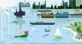
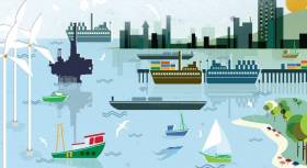
"Strategic marine activity zones" may be designated in coastal and offshore waters as part of the Government's new approach to marine planning.

Offshore wind projects will receive "preference" in marine areas zoned for this, a new draft framework published this morning by Minister of State for Housing Damien English states.

Renewable energy projects, commercial fishing, mineral extraction, aquaculture and other competing interests, including tourism, will be covered by a new single system of consent under long-promised revised legislation.

"Offshore wind projects will receive "preference" in marine areas zoned for this"

Ireland is actually one of the largest EU states if over 490,000 square kilometres of seabed off a 7,500 km coastline is taken into account, the draft framework notes.

As Afloat previously reported, Mr English has released the State’s first such framework in draft form today for a three month public consultation period.

Ireland and other EU coastal states are obliged to establish marine spatial plans by 2021 under an EU directive, and Mr English’s department has been assigned as lead in this.

The national marine planning framework aims to take a “co-ordinated” and “coherent” approach to management of “our most important resource”, it says/

The State’s “Harnessing our Ocean Wealth” strategy, has already set two economic targets – doubling the value of ocean wealth to 2.4 per cent of gross domestic product by 2030, and increasing the turnover of the ocean economy to exceed €6.4 billion by 2020.

Academics at NUI Galway’s Socio-Economic Marine Research Unit have reported that Ireland’s “ocean economy” had a turnover at €5.5 billion in 2017.

One single national marine plan will apply to Ireland’s entire maritime area, extending from mean high water mark on the coast to the 200 mile limits of the exclusive economic zone and Continental Shelf.

However, the draft framework says the Government is “committed” to preparation of regional or sub-national plans in future marine spatial policy cycles

The framework will be underpinned by the Government’s Marine Planning and Development Bill, which will replace the existing cumbersome system of foreshore leases and licenses, and will extend beyond territorial waters.

Friction between offshore renewable energy developments and fishing has already taken place in British waters, and the framework aims to plan for competing interests at a time of growing global pressure on marine resources.

Public consultation has already taken place on a baseline report, which elicited 173 responses, and a “strong consensus” emerged that a “hybrid approach” to marine spatial planning, involving zoning for specific activities or zoning certain areas was preferable to “full zoning” of all Ireland’s seas.

Adoption of the final marine planning framework is “expected” to be late 2020. Closing date for submissions on the draft is February 28th, 2020.

The department says it will “not replace or remove existing regulatory regimes or legislative requirements” governing marine sectoral activities, but public bodies will be obliged to take its objectives into account.

When the new legislation is passed, consents will be issued by two departments, depending on remit – the Department of Housing, Planning and Local Government, and Communications, Climate Action and Environment.

Former Environmental Protection Agency (EPA) director Micheál Ó Cinnéide, who is now co-chair of environmental organisation Corrib Beo, welcomed publication of the draft framework.

However, he has questioned why the State’s Marine Institute or a similar experienced body is not being established to provide a secretariat for the plan.

Mr Ó Cinnéide also warned that the plan needs to be given adequate resources, and the department needs to ensure widespread consultation at both regional and local level before final agreement.

“This plan will stand or fall on how well it works in individual coastal bays,” he said.

Regional public events on the draft marine planning framework will open on November 21st in Limerick, continuing to Westport, Co Mayo (Nov 26), Galway (December 2nd), and Tralee, Co Kerry (December 12th), with further events in Killybegs, Co Donegal, Bantry, Co Cork, Dungarvan, Co Waterford, Dublin and Wexford.

Full details are on www.marineplan.gov.ie

Published in Environment
Tagged under

Maritime spatial planning for Ireland takes a step closer this year thanks to an EU directive first adopted in 2014. The directive obliges all coastal Member States to establish maritime spatial plans by 2021. Member States, including Ireland, must transpose the Directive into national law by 18th September 2016. The Goverment is seeking submissions but the deadline is less than a month away.

Maritime Spatial Planning (MSP) is a new way of looking at how we use the marine area and planning how best to use it into the future. Marine industry activists have long argued the lack of ability to licence the oceans that surround us has been the biggest obstable to developing the 'blue economy' for Ireland.

MSP will try to balance the different demands for using the sea including the need to protect the marine environment. It's about planning when and where human activities take place at sea. It’s about ensuring these activities are as efficient and sustainable as possible. Maritime spatial planning involves stakeholders in a transparent way in the planning of maritime activities. 

The Department of the Environment, Community and Local Government has drafted regulations intended for Irish law and it is inviting submissions on the draft regulations. To assist the Dept has prepared a guidance document showing the relationship between the articles of the Directive and the regulations. More details here

The closing date for submissions is 5.30pm on Friday, 6 May 2016

Draft regulations are attached below

Meanwhile, the sixth conference of the MSP stakeholder series, focusing on MSP Worldwide has been postponed. The conference is now confirmed to be held on 23 - 24 June 2016 at the University of the Azores, Ponta Delgada, Azores.

According to the organisers, the conference will present experiences, opportunities and challenges of MSP implementation around the world. In particular it will look at how MSP can advance Blue Growth world-wide, its potential to promote climate change solutions, as well as at the role of area-based management regimes in international waters. The main purpose is to take stock of what is being done at international level and identify potential synergies as well as possible contributions from European MSP processes.

Published in News Update
Tagged under

#spatialplanning– Maritime Spatial Planning (MSP) is coming to prominence as a new approach to the governance of the seas and oceans.  The European Union has taken important steps to promote the uptake of MSP by Member States. Trans boundary planning in the European Atlantic is a project funded by DG Mare and the first workshop in the project is being held in Newry, Co. Down today.

The project is a partnership between the University of Liverpool and the Coastal Management Resource Centre of UCC. Delegates from a number of N Ireland government departments and the Republic have joined with industry stakeholders to discuss in the workshops some of the issues surrounding MSP. The Irish Marine Federation is the single voice representing the marine leisure sector.

Already the group are settling in to try to develop a methodology to ensure that all sectors will contribute to the debate from a social, environmental and an economic view point.

Steve Conlon of the IMF stated that it is important that the marine leisure industry full engages with this type of forum to ensure that the leisure boating voice continues to be heard.

Published in Marine Science
Tagged under

The Irish Coast Guard

The Irish Coast Guard is Ireland's fourth 'Blue Light' service (along with An Garda Síochána, the Ambulance Service and the Fire Service). It provides a nationwide maritime emergency organisation as well as a variety of services to shipping and other government agencies.

The purpose of the Irish Coast Guard is to promote safety and security standards, and by doing so, prevent as far as possible, the loss of life at sea, and on inland waters, mountains and caves, and to provide effective emergency response services and to safeguard the quality of the marine environment.

The Irish Coast Guard has responsibility for Ireland's system of marine communications, surveillance and emergency management in Ireland's Exclusive Economic Zone (EEZ) and certain inland waterways.

It is responsible for the response to, and co-ordination of, maritime accidents which require search and rescue and counter-pollution and ship casualty operations. It also has responsibility for vessel traffic monitoring.

Operations in respect of maritime security, illegal drug trafficking, illegal migration and fisheries enforcement are co-ordinated by other bodies within the Irish Government.

On average, each year, the Irish Coast Guard is expected to:

  • handle 3,000 marine emergencies
  • assist 4,500 people and save about 200 lives
  • task Coast Guard helicopters on missions

The Coast Guard has been around in some form in Ireland since 1908.

Coast Guard helicopters

The Irish Coast Guard has contracted five medium-lift Sikorsky Search and Rescue helicopters deployed at bases in Dublin, Waterford, Shannon and Sligo.

The helicopters are designated wheels up from initial notification in 15 minutes during daylight hours and 45 minutes at night. One aircraft is fitted and its crew trained for under slung cargo operations up to 3000kgs and is available on short notice based at Waterford.

These aircraft respond to emergencies at sea, inland waterways, offshore islands and mountains of Ireland (32 counties).

They can also be used for assistance in flooding, major inland emergencies, intra-hospital transfers, pollution, and aerial surveillance during daylight hours, lifting and passenger operations and other operations as authorised by the Coast Guard within appropriate regulations.

Irish Coastguard FAQs

The Irish Coast Guard provides nationwide maritime emergency response, while also promoting safety and security standards. It aims to prevent the loss of life at sea, on inland waters, on mountains and in caves; and to safeguard the quality of the marine environment.

The main role of the Irish Coast Guard is to rescue people from danger at sea or on land, to organise immediate medical transport and to assist boats and ships within the country's jurisdiction. It has three marine rescue centres in Dublin, Malin Head, Co Donegal, and Valentia Island, Co Kerry. The Dublin National Maritime Operations centre provides marine search and rescue responses and coordinates the response to marine casualty incidents with the Irish exclusive economic zone (EEZ).

Yes, effectively, it is the fourth "blue light" service. The Marine Rescue Sub-Centre (MRSC) Valentia is the contact point for the coastal area between Ballycotton, Co Cork and Clifden, Co Galway. At the same time, the MRSC Malin Head covers the area between Clifden and Lough Foyle. Marine Rescue Co-ordination Centre (MRCC) Dublin covers Carlingford Lough, Co Louth to Ballycotton, Co Cork. Each MRCC/MRSC also broadcasts maritime safety information on VHF and MF radio, including navigational and gale warnings, shipping forecasts, local inshore forecasts, strong wind warnings and small craft warnings.

The Irish Coast Guard handles about 3,000 marine emergencies annually, and assists 4,500 people - saving an estimated 200 lives, according to the Department of Transport. In 2016, Irish Coast Guard helicopters completed 1,000 missions in a single year for the first time.

Yes, Irish Coast Guard helicopters evacuate medical patients from offshore islands to hospital on average about 100 times a year. In September 2017, the Department of Health announced that search and rescue pilots who work 24-hour duties would not be expected to perform any inter-hospital patient transfers. The Air Corps flies the Emergency Aeromedical Service, established in 2012 and using an AW139 twin-engine helicopter. Known by its call sign "Air Corps 112", it airlifted its 3,000th patient in autumn 2020.

The Irish Coast Guard works closely with the British Maritime and Coastguard Agency, which is responsible for the Northern Irish coast.

The Irish Coast Guard is a State-funded service, with both paid management personnel and volunteers, and is under the auspices of the Department of Transport, Tourism and Sport. It is allocated approximately 74 million euro annually in funding, some 85 per cent of which pays for a helicopter contract that costs 60 million euro annually. The overall funding figure is "variable", an Oireachtas committee was told in 2019. Other significant expenditure items include volunteer training exercises, equipment, maintenance, renewal, and information technology.

The Irish Coast Guard has four search and rescue helicopter bases at Dublin, Waterford, Shannon and Sligo, run on a contract worth 50 million euro annually with an additional 10 million euro in costs by CHC Ireland. It provides five medium-lift Sikorsky S-92 helicopters and trained crew. The 44 Irish Coast Guard coastal units with 1,000 volunteers are classed as onshore search units, with 23 of the 44 units having rigid inflatable boats (RIBs) and 17 units having cliff rescue capability. The Irish Coast Guard has 60 buildings in total around the coast, and units have search vehicles fitted with blue lights, all-terrain vehicles or quads, first aid equipment, generators and area lighting, search equipment, marine radios, pyrotechnics and appropriate personal protective equipment (PPE). The Royal National Lifeboat Institution (RNLI) and Community Rescue Boats Ireland also provide lifeboats and crews to assist in search and rescue. The Irish Coast Guard works closely with the Garda Siochána, National Ambulance Service, Naval Service and Air Corps, Civil Defence, while fishing vessels, ships and other craft at sea offer assistance in search operations.

The helicopters are designated as airborne from initial notification in 15 minutes during daylight hours, and 45 minutes at night. The aircraft respond to emergencies at sea, on inland waterways, offshore islands and mountains and cover the 32 counties. They can also assist in flooding, major inland emergencies, intra-hospital transfers, pollution, and can transport offshore firefighters and ambulance teams. The Irish Coast Guard volunteers units are expected to achieve a 90 per cent response time of departing from the station house in ten minutes from notification during daylight and 20 minutes at night. They are also expected to achieve a 90 per cent response time to the scene of the incident in less than 60 minutes from notification by day and 75 minutes at night, subject to geographical limitations.

Units are managed by an officer-in-charge (three stripes on the uniform) and a deputy officer in charge (two stripes). Each team is trained in search skills, first aid, setting up helicopter landing sites and a range of maritime skills, while certain units are also trained in cliff rescue.

Volunteers receive an allowance for time spent on exercises and call-outs. What is the difference between the Irish Coast Guard and the RNLI? The RNLI is a registered charity which has been saving lives at sea since 1824, and runs a 24/7 volunteer lifeboat service around the British and Irish coasts. It is a declared asset of the British Maritime and Coast Guard Agency and the Irish Coast Guard. Community Rescue Boats Ireland is a community rescue network of volunteers under the auspices of Water Safety Ireland.

No, it does not charge for rescue and nor do the RNLI or Community Rescue Boats Ireland.

The marine rescue centres maintain 19 VHF voice and DSC radio sites around the Irish coastline and a digital paging system. There are two VHF repeater test sites, four MF radio sites and two NAVTEX transmitter sites. Does Ireland have a national search and rescue plan? The first national search and rescue plan was published in July, 2019. It establishes the national framework for the overall development, deployment and improvement of search and rescue services within the Irish Search and Rescue Region and to meet domestic and international commitments. The purpose of the national search and rescue plan is to promote a planned and nationally coordinated search and rescue response to persons in distress at sea, in the air or on land.

Yes, the Irish Coast Guard is responsible for responding to spills of oil and other hazardous substances with the Irish pollution responsibility zone, along with providing an effective response to marine casualties and monitoring or intervening in marine salvage operations. It provides and maintains a 24-hour marine pollution notification at the three marine rescue centres. It coordinates exercises and tests of national and local pollution response plans.

The first Irish Coast Guard volunteer to die on duty was Caitriona Lucas, a highly trained member of the Doolin Coast Guard unit, while assisting in a search for a missing man by the Kilkee unit in September 2016. Six months later, four Irish Coast Guard helicopter crew – Dara Fitzpatrick, Mark Duffy, Paul Ormsby and Ciarán Smith -died when their Sikorsky S-92 struck Blackrock island off the Mayo coast on March 14, 2017. The Dublin-based Rescue 116 crew were providing "top cover" or communications for a medical emergency off the west coast and had been approaching Blacksod to refuel. Up until the five fatalities, the Irish Coast Guard recorded that more than a million "man hours" had been spent on more than 30,000 rescue missions since 1991.

Several investigations were initiated into each incident. The Marine Casualty Investigation Board was critical of the Irish Coast Guard in its final report into the death of Caitriona Lucas, while a separate Health and Safety Authority investigation has been completed, but not published. The Air Accident Investigation Unit final report into the Rescue 116 helicopter crash has not yet been published.

The Irish Coast Guard in its present form dates back to 1991, when the Irish Marine Emergency Service was formed after a campaign initiated by Dr Joan McGinley to improve air/sea rescue services on the west Irish coast. Before Irish independence, the British Admiralty was responsible for a Coast Guard (formerly the Water Guard or Preventative Boat Service) dating back to 1809. The West Coast Search and Rescue Action Committee was initiated with a public meeting in Killybegs, Co Donegal, in 1988 and the group was so effective that a Government report was commissioned, which recommended setting up a new division of the Department of the Marine to run the Marine Rescue Co-Ordination Centre (MRCC), then based at Shannon, along with the existing coast radio service, and coast and cliff rescue. A medium-range helicopter base was established at Shannon within two years. Initially, the base was served by the Air Corps.

The first director of what was then IMES was Capt Liam Kirwan, who had spent 20 years at sea and latterly worked with the Marine Survey Office. Capt Kirwan transformed a poorly funded voluntary coast and cliff rescue service into a trained network of cliff and sea rescue units – largely voluntary, but with paid management. The MRCC was relocated from Shannon to an IMES headquarters at the then Department of the Marine (now Department of Transport) in Leeson Lane, Dublin. The coast radio stations at Valentia, Co Kerry, and Malin Head, Co Donegal, became marine rescue-sub-centres.

The current director is Chris Reynolds, who has been in place since August 2007 and was formerly with the Naval Service. He has been seconded to the head of mission with the EUCAP Somalia - which has a mandate to enhance Somalia's maritime civilian law enforcement capacity – since January 2019.

  • Achill, Co. Mayo
  • Ardmore, Co. Waterford
  • Arklow, Co. Wicklow
  • Ballybunion, Co. Kerry
  • Ballycotton, Co. Cork
  • Ballyglass, Co. Mayo
  • Bonmahon, Co. Waterford
  • Bunbeg, Co. Donegal
  • Carnsore, Co. Wexford
  • Castlefreake, Co. Cork
  • Castletownbere, Co. Cork
  • Cleggan, Co. Galway
  • Clogherhead, Co. Louth
  • Costelloe Bay, Co. Galway
  • Courtown, Co. Wexford
  • Crosshaven, Co. Cork
  • Curracloe, Co. Wexford
  • Dingle, Co. Kerry
  • Doolin, Co. Clare
  • Drogheda, Co. Louth
  • Dun Laoghaire, Co. Dublin
  • Dunmore East, Co. Waterford
  • Fethard, Co. Wexford
  • Glandore, Co. Cork
  • Glenderry, Co. Kerry
  • Goleen, Co. Cork
  • Greencastle, Co. Donegal
  • Greenore, Co. Louth
  • Greystones, Co. Wicklow
  • Guileen, Co. Cork
  • Howth, Co. Dublin
  • Kilkee, Co. Clare
  • Killala, Co. Mayo
  • Killybegs, Co. Donegal
  • Kilmore Quay, Co. Wexford
  • Knightstown, Co. Kerry
  • Mulroy, Co. Donegal
  • North Aran, Co. Galway
  • Old Head Of Kinsale, Co. Cork
  • Oysterhaven, Co. Cork
  • Rosslare, Co. Wexford
  • Seven Heads, Co. Cork
  • Skerries, Co. Dublin Summercove, Co. Cork
  • Toe Head, Co. Cork
  • Tory Island, Co. Donegal
  • Tramore, Co. Waterford
  • Waterville, Co. Kerry
  • Westport, Co. Mayo
  • Wicklow
  • Youghal, Co. Cork

Sources: Department of Transport © Afloat 2020