


Displaying items by tag: Dundalk Bay
Uncrewed Vessel Trials in Dundalk Bay Ahead of Oriel Wind Farm Survey
Trial operations of remotely piloted uncrewed surface vessels (USVs) are planned to take place in the Dundalk Bay area from this week until mid November.
Subject to weather and operational constraints, the operations will run for a period of four weeks from Thursday 20 October.
The XO-450-type USVs from Greenore-based Xocean will be engaged in survey activities for the proposed Oriel Wind Farm in the Irish Sea some 22km off the coast of Dundalk in Co Louth.
This is a non-invasive survey, Xocean says, and no contact with the seabed or any other infrastructure is planned during survey operations.
The USVs will send real-time images and situational awareness data over satellite to a team of operators keeping watch and controlling the vessel remotely 24/7.
Although the vessels are uncrewed, they are constantly monitored and controlled, and piloted remotely using 360-degree cameras and other navigational aids.
Each USV is equipped with AIS, navigation lights and a sound signal, an active radar reflector and a yellow-painted superstructure to make it conspicuous to other marine traffic.
All other vessels operating within the affected area are requested to avoid contact with any USV and be aware of the operational area during this period. A Radio Navigation Warning will be in place during operations.
Contact details, relevant coordinates and a map of the survey area are included in Marine Notice No 71 of 2022, attached below.
Environmental Survey by Uncrewed Vessel in Dundalk Bay This Week
Survey operations conducted by an uncrewed surface vessel (USV) are taking place in Dundalk Bay this week.
The remotely piloted X-09 — from Greenore-based Xocean — was scheduled to launch from Clogherhead, Co Louth today, Tuesday 25 January, for the weeklong survey.
It will be engaged in survey activities supporting environmental research in the area. The survey will utilise multibeam echosounder to characterise the seabed across the site.
The USV sends real-time images and situational awareness data over satellite to a team of operators keeping watch and controlling the vessel remotely 24/7.
A Radio Navigation Warning will be in place during operations, and the USV has been made conspicuous to other marine traffic via its yellow superstructure, AIS, navigation lights and sound signal, and active radar reflector.
Coordinates and maps of the survey area are included in Marine Notice No 05 of 2022, attached below.
All other vessels operating within this area are requested to avoid contact with the USV and be aware of the operational area during this period.
The Dundalk Bay cockle fishery is the subject of a public consultation opened this week by the Department of Agriculture, Food and the Marine.
Views of all those with an interest in the fishery are sought regarding the permits policy in this consultation which is being carried out in conjunction with the review of the relevant Fisheries Natura Plan.
The department says feedback received during the consultation will inform decisions on further development of the permits policy, in particular “a transparent set of criteria for issuing additional permits in future years where the fishery biomass and total allowable catch are sufficient to accommodate additional fishers”.
Submissions can be made online or by post — after downloading and completing the Consultation Submission Document available HERE — before the closing date of Friday 18 June.
Enquiries concerning this consultation are directed to [email protected]
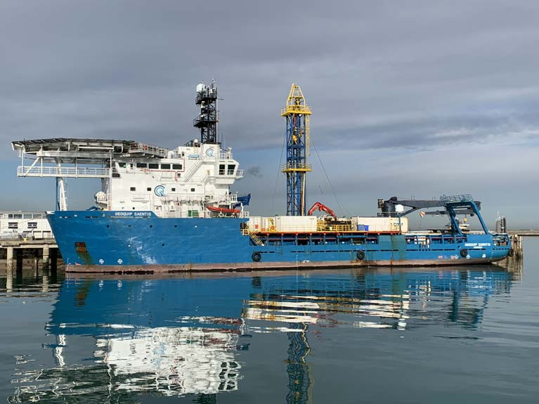
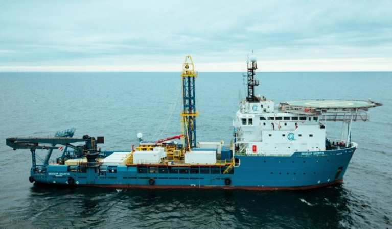
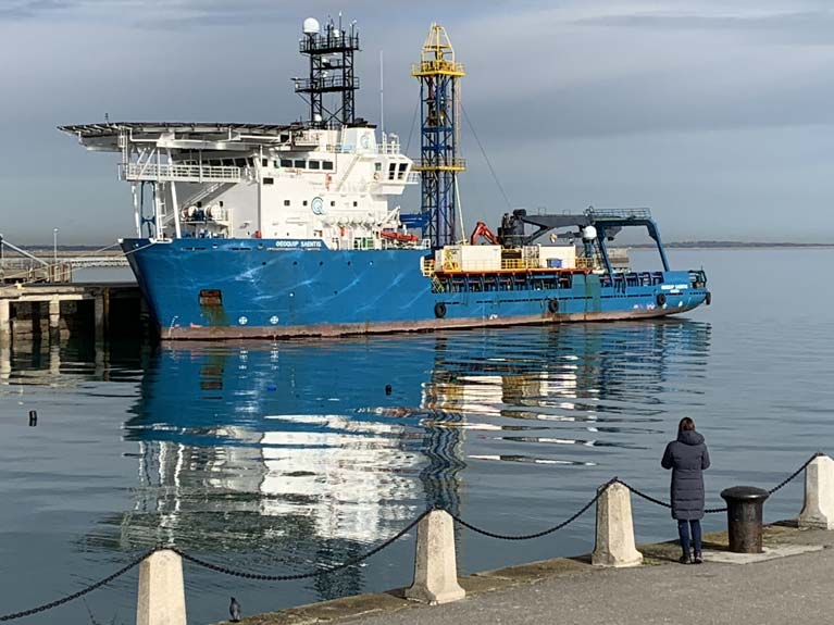
'Geoquip Saentis' Berthed in Dun Laoghaire Harbour is Bound for Oriel Windfarm in Dundalk Bay
Geotechnical surveys will take place in Outer Dundalk Bay from 6 March 2020, according to the Department of Transport, Tourism and Sport in Marine Notice No. 13 of 2020.
The survey will be completed using the “Geoquip Saentis” (Callsign: C6UM8) currently berthed in Dun Laoghaire Harbour.
The work is necessary to provide geotechnical data to facilitate the development of the Oriel Windfarm.
The survey is expected to start on 6 March 2020 and is expected to be completed by 27 March 2020 but dates provided are weather dependant and therefore subject to change.
When the survey vessel is engaged in survey operations, it will be restricted in its ability to manoeuvre. Other vessels are requested to leave a wide berth. The vessel will be operating 24 hours a day, 7 days a week during the survey works.
Download the full notice below.
Drilling-Rig Ship Operated by Landlocked Shipping Company Calls to Dun Laoghaire Harbour
A drilling-rig ship operated by a Swiss-based offshore geo technical data solutions company is currently berthed in Dun Laoghaire Harbour, writes Jehan Ashmore.
According to Dun Laoghaire-Rathdown County Council, the drilling-rig ship Geoquip Saentis is in the harbour to mobilise for work on the Oriel Wind Farm project to the east of Dundalk Bay. The vessel is expected remain in port until tomorrow or Friday.
The 3,404 gross tonnage drill-ship run by Geoquip Marine Operations AG based in St. Gallen, in north-east Switzerland near Liechtenstein, specialises in diverse market segments among them Offshore Renewables, Oil & Gas and Mineral Extraction.
The Swiss shipping firm has a fleet of offshore geotechnical drilling rigs. As for Geoquip Saentis, this drilling rig ship has a Dynamic Positioning (DP2) system for navigational on-site high precision accuracy. In addition, the Multi-Purpose Offshore Support vessel has an on board soil laboratory where data is analysed for clients of projects that can be nearshore (as in project in Dundalk Bay) to waters of ultra-deep oceans.
Afloat tracked the Geoquip Saentic which sailed from Nigg on the Gromarty Forth in north-east Scotland. Also offshore of Aberdeen, the ship in October completed its first geotechnical site investigation in the North Sea involving drilling to over 2000 metres.
The arrival of Geoquip Saentis to the Irish Sea involved a transit through the North Channel. After anchoring in Dublin Bay yesterday, a pilot was transferred on board from Dublin Port Company's new cutter DPC Tolka as previously reported.
 Geoquip Saentis along side in Dun Laoghaire Photo: Afloat
In observing the design of Geoquip Saentis, Afloat concluded the vessel was a former platform supply vessel (PSV) which has been identified as the former Toisa Viligant. The vessel built in 2005 was specially designed to supply offshore oil and gas platforms. Following the acquisition by Geoquip Marine which coincidentally took place on this date exactly a year ago, the ship received conversion overhaul works to enable offshore geotechnical operations.
The major overhaul of Geoquip Saentis took place in the UK at Cammell Laird, the shipyard on Merseyside (see yesterday's Afloat coverage) of the Royal Fleet Auxiliary's tanker RFA Fort Victoria.
The drilling ship was dry-docked at the facility in Birkenhead on the Wirral Peninsula, which included notably the installation of Geoquip’s GMR600 marine drill-rig situated amidships as demonstrated in the above photo. Underneath the rig is a 4m x 4m moon pool.
Geoquip Saentis has accommodation and workspaces for 55 crew members. At 80m in length and an 18m beam, this provides a stable platform for offshore geotechnical operations which includes use of a Remotely Operated Vessel (ROV) to operate alongside the drill-rig.
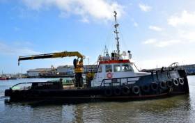
Geophysical surveys are being undertaken in the Irish Sea in outer Dundalk Bay from this week.
The work is required to provide bathymetric and subsurface information for the development of the Oriel Wind Farm project.
Survey work was expected to start yesterday, Tuesday 20 August, with a view to completion by Monday 30 September, though these dates are weather dependent.
The surveys will be completed using the AMS Retriever (Callsign MEHI8), a versatile multi-purpose, shallow draft tug.
This vessel is towing survey equipment up to 100 metres astern and will be restricted in its ability to manoeuvre.
Other vessels are requested to leave a wide berth. The AMS Retriever will be operating from approximately 6am to 9pm during survey works.
Details of co-ordinates of the survey area are included in Marine Notice No 29 of 2019, a PDF of which is available to read or download HERE.
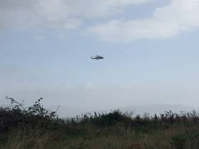
#Ophelia - Windsurfers on the Louth coast have been roundly criticised on social media as they prompted a major rescue operation before the arrival of Storm Ophelia, as TheJournal.ie reports.
The four windsurfers, originally thought to be kitesurfers, made their own way to shore after getting 'into difficulty' this morning — but not before Clogherhead RNLI, Greenore Coast Guard and the Dublin-based Irish Coast Guard rescue helicopter had launched to their location, off Blackrock in Dundalk Bay.
The Irish Coast Guard has repeated widespread calls to stay away from the coast during the current storm conditions throughout Ireland.
2 kite surfers safely escorted to shore with @GreenoreCG, @ClogherheadRNLI, Rescue116 and local Garda present@TOTTDundalk @rtenews pic.twitter.com/fss1F91cVx
— Carlingford (@CarlingfordIRE) October 16, 2017
This article was changed to correct an error in the number of windsurfers involved in this morning's incident.
Killer Whales, Minkes Spotted Off Coast

The Irish Whale and Dolphin Group (IWDG) has announced two new reports of whale spottings off the Irish coast in recent days.
On 14 October the east coast rescue helicopter spotted a group of at least five lunge-feeding whales just four miles off Dunany Point on the southern side of Dundalk Bay.
Their relatively small size, white banding on the pectoral fin and absense of any obvious blow confirmed them to be minkes - a marine wildlife record for the area.
"This is further proof, not that it is needed, that there is a growing list of places outside of the expected 'hotspots' where whale activity is now being documented," said the IWDG's Pádraig Whooley.
Yet more were spotted on the opposite coast the day after, when Nick Massett reported up to a dozen minke whales in a 1.5-mile box off Slea Head, near Dingle.
Meanwhile, this week a group of four killer whales was observed by the FV Celtic Cross on the prawn grounds off Co Louth, travelling in a north-westerly direction towards Dundalk Bay.
"There may well be something very interesting happening in this section of the Irish Sea that is attracting both baleen and toothed whale in the same area," said Whooley.


")


 Michael Murphy Schull Harbour Sailing Club (SHSC), Eric Coogan Heineken Ireland, Mark Murphy, Commodore SHSC, Jack Allen SHSC, Carmel O'Regan SHSC, Cornelious Ndlovu, Schull Harbour Hotel Operations Manager and Derval Murphy SHSC")


