


Displaying items by tag: Geotechnical Survey
Fuinneamh Sceirde Teoranta (FST) will be undertaking both a geotechnical survey and geophysical survey for the Sceirde Rocks Windfarm Project in the Western Coastal Area (Connemara/Outer Galway Bay) and Atlantic Ocean, between Monday 15 April and Monday 10 June, subject to weather and operational constraints.
These surveys follow last September’s geophysical survey and will be undertaken by the multi-purpose offshore vessel Dina Polaris (callsign CQOF), which is fitted with a geotechnical drilling rig, and the research vessel Lady Kathleen (callsign EIXT2). Both vessels will operate up to 24 hours per day and will be displaying the appropriate lights and shapes.
During operations, the vessels will be restricted in their ability to manoeuvre. Therefore, passing vessels are requested to leave a wide berth during the deployment operations. Radio transmissions will be conducted with other seafarers to notify them of the operations. The vessels will be monitoring VHF Channel 16 at all times for safety purposes.
The equipment for each survey will be deployed within the bounds of the survey areas detailed in Marine Notice No 17 of 2024, attached below.
The Department of Transport has been advised by Fuinneamh Sceirde Teoranta (FST) that benthic and geotechnical survey vessels will be deployed at the site of the proposed Sceirde Rocks Windfarm in north Galway Bay off southwestern Connemara.
The deployment will take place from this Saturday 29 July — as with the metocean survey previously reported on Afloat.ie — to the end of September, subject to weather and operational constraints.
The benthic survey will take place using the vessel Ocean Navigator (callsign EI018) which will operate in daylight hours. The geotechnical survey will take place using the vessels Geoquip Seehorn (callsign 5BSW) and Glomar Vantage (callsign HO3057) which will operate on a 24-hour basis.
Coordinates and a map of the deployment area as well as contact details can be found in Marine Notice No 47 of 2023, attached below.
Marine Notice: Cable Burial Assessment Survey in Irish Sea
The Department of Transport has been advised that a geophysical and geotechnical surveys is being undertaken by Green Rebel Marine in the Irish Sea to assess cable burial on behalf of MDM.
The survey work was anticipated to start on Monday 19 June and will be completed by the end of September, subject to weather and operational constraints.
Surveys will be conducted by two vessels: the semi-SWATH catamaran Roman Rebel (callsign 2ICA5) which will conduct 24-hr operations, and the Lady Kathleen (callsign EIXT2), a catamaran which will conduct 12-hr operations. Both vessels will display appropriate lights and signals.
As the survey vessels will be restricted in their ability to manoeuvre when surveying, due to the deployment of the towed survey equipment from the vessel for the duration of the survey activities, other vessels are kindly requested to keep a wide berth.
Mariners are advised to keep continuous watch on VHF Channel 16 when navigating the area.
Coordinates and a map of the survey areas as well as contact details can be found in Marine Notice No 40 of 2023, attached below.
Marine Notice: Surveys Off West and Southeast Coasts
EGS International Ltd is undertaking a geophysical survey campaign for a proposed offshore wind farm and associated export cable corridor centred around Sceirde Rocks, off the west coast of Ireland near Galway.
The survey was set to commence last week on Friday 10 June and will continue throughout June, July and possibly into August, weather permitting.
The operations will take place in two locations: the Wider Array Site off the coast of Connemara and the Export Cable Corridor (ECC) to the west of the Aran Islands and towards the coast of Co Clare.
The work is being conducted by the EGS Ventus (callsign V7119), which will display the appropriate day shapes/signals and lights as required by the COLREGS and maintain a continuous listening watch on VHF Channel 16 and Digital Selective Calling (DSC).
The vessel will be towing survey equipment astern at 4 knots, which will restrict its ability to manoeuvre. All other vessels operating within this area are requested to keep their distance and pass at minimum speed to reduce vessel wash.
Contact details, coordinates and maps of the survey areas are included in Marine Notice No 36 of 2022, attached below.
Elsewhere, Fugro is engaged in a geotechnical site survey campaign for wind farms in the South Irish Sea (off the Wexford coast) and North Celtic Sea (off the Waterford coast).
Operations were expected to begin on Sunday 12 June and will continue till approximately Tuesday 28 June, weather allowing.
The work is being conducted by the Normand Mermaid (callsign LAXH7) on a 24-hour basis. The vessel will display appropriate lights and markers.
For further details see Marine Notice No 35 of 2022, also attached below.
Following the recent deployment of Metocean devices to provide data for the development of the Arklow Bank Wind Park, a geotechnical survey will take place in the same areas of the Irish sea off the Wicklow coast in the coming weeks.
The survey will start in late August or early September, weather depending, and will continue to November. Survey activity will involve drilling around 15 boreholes in the area detailed in Marine Notice No 33 of 2020, available to download below.
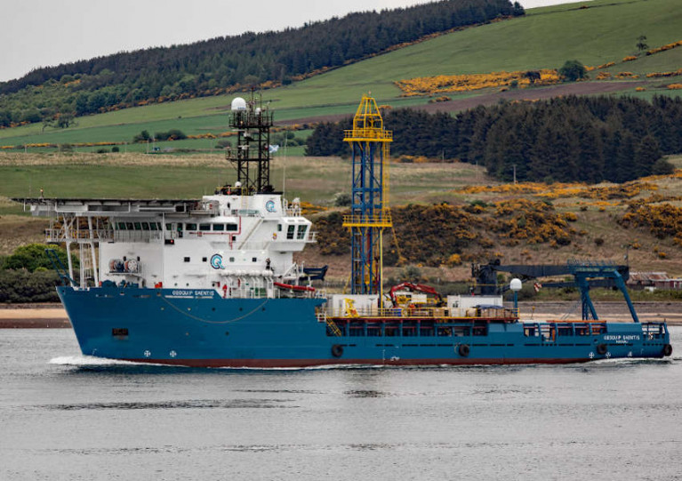
Survey works will be conducted by contractor Geoquip Marine using the Geoquip Saentis (Callsign C6UM8), an 80m dynamically positioned specialist survey vessel.
The Geoquip Saentis will be restricted in its ability to manoeuvre during its 24/7 survey operations, and other vessels in the are are requested to leave a wide berth.
Marine Notice: Offshore Geotechnical Survey Off Killard, Co Clare
#MarineNotice - The latest Marine Notice from the Department of Transport, Tourism and Sport (DTTAS) advises that ESB International is carrying out a geotechnical survey at the WestWave ocean energy site off the coast of Killard, Co Clare this week.
The survey started Tuesday 22 September and will last between eight and 11 days, weather permitting.
The RV Celtic Voyager (callsign EIQN) is carrying out the work, deploying equipment such as a Vibrocore and a cone penetrometer.
The vessel will be restricted in its ability to manoeuvre while carrying out the survey, and all vessels, particularly those engaged in fishing, are requested to give this operation a wide berth and keep a sharp lookout in the relevant areas.
The work vessel will be listening on VHF Channel 16 throughout the project.
Full details of co-ordinates are included in Marine Notice No 46 of 2015, a PDF of which is available to read or download HERE.


