


Displaying items by tag: Metocean
Marine Notice: Deployment of Metocean Data Buoy West of Inishmaan
The Department of Transport has been advised of the deployment of a metocean data buoy by University College Dublin west of Inishmaan, some 6.6 nautical miles off Eeragh Lighthouse on Rock Island.
This deployment is scheduled to take place from Sunday 22 October for a period of up to seven days, subject to weather and operational constraints.
It will be carried out by the MV Chateau-Thierry (callsign EIHK6) which will display appropriate lights and signals.
Navigational warnings will be issued by radio when the marker buoy deployment takes place. A yellow special mark plastic buoy, IALA category 3 and 2.5m in diameter, will be used with a navigation light flashing white every 20 seconds at 4.1 meters above the surface.
Coordinates and a map of the deployment area, as well as contact details, can be found in Marine Notice No 65 of 2023, attached below.
The Department of Transport has been advised by Fuinneamh Sceirde Teoranta (FST) that a metocean survey comprising one large metocean buoy and two trawl resistant seabed frames will be deployed at the site of the proposed Sceirde Rocks Windfarm in north Galway Bay off southwestern Connemara.
The deployment will take place between this Saturday 29 July and the end of August, subject to weather and operational constraints.
Equipment will remain in place for up to 24 months, and periodic service visits to the equipment will take place throughout the survey period.
The metocean buoy has a hull diameter of 3.6m and focal height of 4m. The buoy is yellow in colour and displays a St Andrew’s Cross. It is mounted with one automatic identification system (AIS) unit (161.975 MHz) and one navigation light (sequence Fl(5) 20s, range 3nm).
The buoy is double moored using a mooring chain and sinker blocks. The anchor and sinkers will be placed approximately 200m away from the metocean buoy. The mooring line will consist of approximately 200m of chain per leg, partially suspended in the water column and partially laying on the seabed.
The trawl-resistant seabed frames are approximately one square metre each and will be unmarked.
This metocean equipment will be deployed from the ILV Granuaile (callsign EIPT), which will operate on a 24-hour basis. Throughout operations, the vessel will display the appropriate lights and shapes as required under the COLREGS Rule 27 (b).
During operations, the vessel will be restricted in its ability to manoeuvre. Vessels are requested to leave a wide berth during the deployment operations.
Radio transmissions will be conducted with other seafarers to notify them of the operations. All vessels will monitor VHF Channel 16 for emergency communications with other seafarers and then mutually agree another channel to switch to for further discussion as needed.
Coordinates and a map of the deployment area as well as contact details can be found in Marine Notice No 46 of 2023, attached below.
Buoy Deployment for Metocean Survey of Proposed Clogherhead Offshore Wind Farm Site
Techworks Marine is deploying three surface buoys with single-point moorings for a metocean survey campaign at the site of the proposed Clogherhead Offshore Wind Farm.
It follows a geophysical survey campaign conducted by Alpha Marine this past summer, as previously reported on Afloat.ie.
These deployments are expected to be completed over a two-day period, at the next available weather window from Sunday 6 November, subject to weather and operational constraints.
Once deployed, the met ocean devices will remain on site for a period of up to 12 months.
The survey campaign will be undertaken within the proposed Clogherhead Offshore Wind Farm site, located some 10km from the Co Louth coast. Detailed coordinates and a map of the survey area are included in Marine Notice No 76 of 2022, attached below.
Three yellow buoys will be deployed, each with a hull diameter of 1.2m and a nominal freeboard of 0.7m. The buoys will display a St Andrew’s Cross day mark, and are fitted with a radar reflector and navigation light with a three nautical mile range, flashing a sequence of five flashes every 20 seconds.
Deployment operations will be conducted by the twin-hulled multi-cat work vessel MPV Skua (callsign 2GDE3).
During works, the vessel will be restricted in its ability to manoeuvre so all other vessels are requested to leave a wide berth during the deployment operations. Radio transmissions will be conducted with other seafarers to notify them of the operations.
Recovery and Redeployment of Floating Lidar and Wave Buoys on Bray and Kish Banks
Marine Notice 37 of 2021 advised of the deployment of one floating lidar buoy and two wave buoys at the Dublin Array offshore wind farm on the Bray and Kish Banks.
The Department of Transport has now been advised by Partrac Ltd that all three Metocean buoys are scheduled to be serviced soon over a period of two days.
Weather permitting, it is expected that the two wave buoys will be recovered and redeployed in the three-week period between tomorrow, Friday 11 February and Friday 4 March.
The floating lidar buoy will be towed from its location on Bray Bank to Wicklow Harbour for routine maintenance overnight and towed back to Bray Bank for redeployment in its current position. This recovery and redeployment will take place in the three-week period between Thursday 24 February 2022 and Friday 18 March.
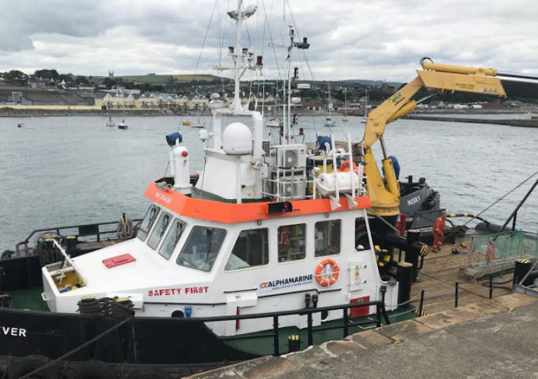
The AMS Retriever (callsign MEHI8) will recover and redeploy all three buoys. The floating lidar buoy will be towed some 30 metres astern of the AMS Retriever at a maximum speed of 3.5 knots.
During this time, the vessel will be restricted in its ability to manoeuvre. As such, vessels operating within this area are requested to keep their distance, maintaining a safety zone around the deployment vessel, and pass at minimum speed to reduce vessel wash.
Radio transmissions will be conducted with VTS and other seafarers to notify them of the buoy operations.
Coordinates of the buoy locations and contact details can be found in Marine Notice No 10 of 2022, attached below.
Partrac Ltd intend to deploy three Metocean buoys at the Dublin Array offshore wind farm in a one-day operation some time between this Wednesday 9 and Wednesday 23 June, weather permitting.
One floating lidar buoy and two wave buoys will be deployed by the AMS Retriever (callsign MEHI8) which will be displaying all appropriate lights and shapes.
The floating lidar buoy has a square footprint with an area of 4m2 and a height of some 4m above the water line. It is yellow in colour and has a St Andrew’s cross on top.
The wave buoys are spherical in shape with a diameter of around 1.1m. When deployed, the wave buoys appear clear with a yellow hull.
Both the floating lidar buoy and the wave buoys have a yellow light which emits five flashes every 20 seconds. The light is visible for up to three nautical miles.
The floating lidar buoy will be deployed for a period of four to eight weeks. It will then be moved to a permanent position in the south end of Dublin Array where it will be deployed for 18 months. The wave buoys will be deployed for a period of 12 months.
The floating lidar buoy will be towed approximately 30m astern of the AMS Retriever at a maximum speed of four knots.
As such, the vessel will be restricted in its ability to manoeuvre so all other boats operating in proximity are requested to keep their distance, maintaining a safety zone around the deployment vessel and pass at minimum speed to reduce vessel wash.
Details of the buoy locations are included in Marine Notice No 37 of 2021 which can be downloaded below.
Deployment Of Wave Monitoring Devices Off Wicklow Coast
Metocean devices will be deployed in the Irish Sea off the Wicklow coast) in the coming days, weather permitting, to provide environmental data for the development of the Arklow Bank Wind Park.
Similar to last autumn’s deployment, four separate devices to monitor waves and currents will be deployed, which will include a seabed frame with the sensors mounted on it, an anchoring system, and a surface marker buoy.
The devices will be deployed using either the AMS Retriever (Callsign MEHI8) or Husky (Callsign 2EQI7), both versatile multi-purpose shallow draft tugs. The devices will remain in place for approximately six months, serviced on a three-monthly basis.
During deployment and recovery operations, the AMS vessel will be restricted in its ability to manoeuvre. The devices will be located using yellow special mark buoys which will have the relevant markers and ATON characters.
The location of the devices will be off the Wicklow coastline as detailed in Marine Notice No 31 of 2020, which is available to download below.
Marine Notice: Metocean Deployment Off Wicklow Coast
Metocean devices will be deployed in the Irish Sea off the Wicklow coast in late October/early November, subject to weather conditions, to facilitate the development of the Arklow Bank Wind Park.
Five separate devices are being deployed which will include a seabed frame with sensors mounted on it, an anchoring system and a surface marker buoy, according to a recent Marine Notice from the Department of Transport, Tourism and Sport.
The devices will be located off the Wicklow coastline, with locations detailed in Marine Notice No 48 of 2019, a PDF of which is available to read or download HERE.
The devices will be deployed using the shallow draft tug AMS Retriever (callsign MEHI8) and will remain in place for approximately one year, serviced on a quarterly basis.
During deployment and recovery operations, the AMS Retriever will be restricted in its ability to manoeuvre.
The devices, similar to that recently deployed at the Oriel Windfarm in Dundalk Bay, will be located using yellow special mark buoys which will have relevant markers and ATON characters.


")


 Michael Murphy Schull Harbour Sailing Club (SHSC), Eric Coogan Heineken Ireland, Mark Murphy, Commodore SHSC, Jack Allen SHSC, Carmel O'Regan SHSC, Cornelious Ndlovu, Schull Harbour Hotel Operations Manager and Derval Murphy SHSC")


