


Displaying items by tag: HAVFRUE
Marine Notice: Extended Cable Route Survey Off West Coast
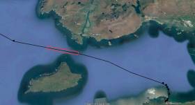
#MarineNotice - Fugro will be carrying out further marine operations on behalf of TE Subsea Communications LLC for the HAVFRUE Subsea Cable System Project south of Achill Island from this week.
The operations are an extension of the project outlined in Marine Notice No 22 of 2018 and are scheduled to be carried out between Saturday 13 July and Saturday 17 August, to last for approximately one day weather permitting.
Works will be undertaken by the RHIB Diversity (Callsign: EI-SV-7), which will be towing equipment such as a magnetometer and a side scan sonar to be used during the shallow water phase, from 50m of water depth and shallower.
Survey operations will be conducted on a 24-hour basis. The vessel will display shapes and lights prescribed in the International Rules for the Prevention of Collisions at Sea (COLREGS) Rule 27, to indicate that the survey vessel is restricted in its ability to manoeuvre. A listening watch will be maintained on VHF Channel 16.
Details of the location of the project are outlined in Marine Notice No 29 of 2018, a PDF of which is available to read or download HERE.
Marine Notice: Cable Route Survey In Irish Territorial Waters
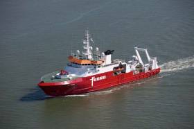
#MarineNotice - Fugro is currently carrying out marine operations for the HAVFRUE Subsea Cable System Project, further to its work carried out in January.
The current survey within Irish territorial waters off the North West Coast began on Wednesday 14 March and is expected to run till midweek next week.
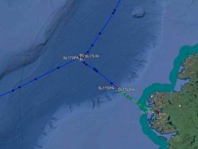
The MV Fugro Discovery (Callsign 3EKE6) is surveying on Segment 2 within Irish EEZ waters towards the 1,500m contour line at the shelf, followed by operations at the BU1 position and Segment 3 as indicated on the charts included with Marine Notice No 10 of 2018, a PDF of which is available to read or download HERE.
Marine Notice: Cable Route Survey Off North-West Coast
#MarineNotice - Fugro will be carrying out marine operations on behalf of TE Subsea Communications LLC for the HAVFRUE Subsea Cable System Project from this weekend.
The survey project is scheduled to begin on Saturday 20 January and last for around 14 days, weather permitting, as conducted by the MV Fugro Discovery (Callsign 3EKE6).
Survey operations will be conducted on a 24-hour basis. Throughout, the vessel will be displaying the shapes and lights prescribed in the International Rules for the Prevention of Collisions at Sea (COLREGS) Rule 27, to indicate that the survey vessel is restricted in its ability to manoeuvre.
A listening watch will be maintained on VHF Channel 16, and the vessel will actively transmit an AIS signal.
The survey comprises a dynamic programme to be conducted in several stages. The survey vessel will be deployed within the working area at times and positions determined by client requirements, weather and sea conditions.
Co-ordinates of the survey area are included in Marine Notice No 02 of 2018, a PDF of which is available to read or download HERE. Please note that the survey within Irish territorial waters as indicated is not part of this notice and will be undertaken at a later date under separate notification.


 helicopter and fixed-wing aviation")
")


 John Stapleton, Robbie Quinn and Helm Alan Goucher")


 Michael Murphy Schull Harbour Sailing Club (SHSC), Eric Coogan Heineken Ireland, Mark Murphy, Commodore SHSC, Jack Allen SHSC, Carmel O'Regan SHSC, Cornelious Ndlovu, Schull Harbour Hotel Operations Manager and Derval Murphy SHSC")


