


Displaying items by tag: Marine Notice
#MarineNotice - Shell E&P Ireland were scheduled to commence flowline installation works between two existing subsea wells at the Corrib gas field this week.
This work will be followed by placement of rock protection along the length of the exposed flowline between the two wells.
There may also be some additional rock placement along the pipeline corridor from the offshore field to the landfall at Broadhaven Bay.
The works, due to commence during this last week of July, are expected run for 30 to 40 days.
The first phase of works will all take place within the 500m Safety Zone surrounding the wells P2 and P5, and along the corridor between P2 and P5.
Carried out by the Skandi Neptune (callsign 2HMG8), the work involves the lay of a new flowline between the two wells followed by connection at each end and pressure testing.
Final seabed connections will be completed on the existing seabed control umbilical followed by the commissioning of the P2 well control system.
This work is expected to be completed by mid August, after whic the Nordnes (callsign PHOG) will commence the second-phase rock placements.
The guard vessel Glomar Arctic (callsign H09083) will be on location in the Corrib Field for the duration of the project. Radio warnings will be given to all marine traffic in the
immediate area. All the vessels will be listening on VHF Channel 16 throughout the project.
Details of co-ordinates of the relevant work areas are included in Marine Notice No 29 of 2016, a PDF of which is available to read or download HERE.
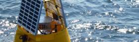
Meanwhile, TechWorks Marine were scheduled to deploy two temporary buoys in the Shannon Estuary on Friday 29 July.
The buoys are required for the placement of turbidity sensors before and during a dredge campaign, and will be in place for the next four weeks.
These data buoys, deployed on a single point mooring, are 1.2m wide, are yellow in colour and have a yellow navigation light with a 2nm range, with five flashes every 20 seconds.
Co-ordinates are included in Marine Notice No 30 of 2016, a PDF of which is available to read or download HERE.
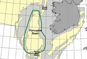
#MarineNotice - CGG Services SA is scheduled to carry out an extensive multi-client 3D seismic survey in the Porcupine Basin off the southwest coast of Ireland.
The seismic survey, named Ireland 2016 MC3D MSS, is further sub-divided into two areas called Area A (in the western area) and Area B (in the southern area).
CGG will start the seismic survey in Area A. The duration of survey in this area will be 25 days. Following the completion of survey in Area A, CGG will start acquiring Area B. This is expected to start late July 2016.
Survey Area A will cover 1,012 sq km and is anticipated to commence in the third week of June 2016. The expected duration is approximately 30 days, subject to weather conditions. Survey Area B will cover 4,078 sq km and is anticipated to commence in the third week of July 2016. The expected duration is approximately 65 days, again subject to weather.
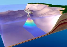
The survey vessel RV Oceanic Endeavour (Callsign 3EJQ7) is scheduled to carry out the work. The vessel will tow 14 separate 8,100m-long solid streamers, with a separation of 100m and at depth of 12m below the surface of the water.
Active radar transponders and flashing navigation lights will be on the outer streamer tail buoys. The seismic vessel and equipment will traverse along pre-determined lines NW-SE across the operations area at a speed of approximately 4.5 knots.
The seismic vessel will be accompanied by support vessel MV Bourbon Grebe (Callsign 5BAT4) and guard vessel MV Stormhav (Callsign V4VD2).
Fishery liaison officers (FLOs) will be on board the RV Oceanic Endeavour to ensure communications with fishermen are clear and timely. All vessels engaged on this survey will be listening on VHF Channel 16 at all times throughout the project.
All other vessels, particularly those engaged in fishing, are requested to give the RV Oceanic Endeavour and her towed equipment a wide berth and keep a sharp lookout in the relevant areas.
Full details of the survey area are included in Marine Notice No 28 of 2016, a PDF of which is available to read or download HERE.
#MarineNotice - The latest Marine Notice from the Department of Transport, Tourism and Sport (DTTAS) advises that site investigation works are to be carried out at Castletownbere Fishery Harbour Centre in West Cork.
The work will comprise of drilling multiple boreholes at the locations, subject to minor variations, indicated in Marine Notice No 24 of 2016, a PDF of which is available to read or download HERE.
Work was expected to begin yesterday (Thursday 26 May) and will finish on or around Friday 22 July, weather permitting.
A jack-up barge will be moved to the various borehole locations by a tugboat and will remain on site overnight during the operations.
All appropriate lights will be displayed by the barge at night. Radio warnings will be transmitted on VHF channel 16 throughout the works.
Possible Debris In Irish EEZ From Soyuz Launch

#MarineNotice - The Department of Transport, Tourism and Sport (DTTAS) has been advised by the Government of France about the planned launch of the rocket Soyuz VS15 from Kourou Spaceport in French Guyana on or around next Tuesday 24 May.
Following the launch, some elements of the launcher may land in the Atlantic Ocean around 356km off the Irish coast within the Exclusive Economic Zone (EEZ) of Ireland.
Any shipping within the affected area during the launch period is hereby advised to be alert to the general maritime safety risk in the area.
Co-ordinates and a map of the affected area are included in Marine Notice No 23 of 2016, a PDF of which is available to read or download HERE.
Marine Notice: Air-To-Ground Shoot At Gormanston Ranges
#MarineNotice - Following April's air defence shoot, the Defence Forces will be conducting an air-to-ground shoot at Gormanston Ranges between 16 and 28 May (excluding Sunday 22 May) from 10am to 6pm each day.
The danger area (EID1) comprises the lands of Gormanston Aerodrome and the air and sea areas contained within a radius of three nautical miles centred on Gormanston Aerodrome.
An additional area is contained within a segment centred on Gormanston Aerodrome and bearing of 015º degrees true, through Mosney Railway Station and 106º degrees true, through Gormanston Railway Station seawards for a distance of 10 nautical miles.
For the periods while the range is active, the sea zone within the danger area is out of bounds to all vessels. A Naval Service patrol vessel will enforce the exclusion zone ‘D1’ as indicated on UKHO Chart No 44.
All vessels are advised that they are required to remain outside of the exclusion zone while the range is active. Vessels in the area are recommended to carefully monitor the Radio Navigation Warnings that will be broadcast during the firing period.
#MarineNotice - Following its scheduled survey under Licensing Option 16/14 later this month, PGS Geophysical AS is scheduled to carry out a second 3D seismic survey, this time in the North Porcupine Basin, from mid-June.
The survey over Frontier Exploration Licenses (FELs) 3/14 and 5/14 has been named 'Bréanann' and will cover 2,400 sq km over some 40 days, subject to weather. The same survey and support vessels will carry out this second survey.
Full details including co-ordinates can be found in Marine Notice No 21 of 2016, a PDF of which is available to read or download HERE.
Marine Notice: 3D Seismic Survey In Porcupine Basin

#MarineNotice - The latest Marine Notice from the Department of Transport, Tourism and Sport (DTTAS) advises that PGS Geophysical AS, on behalf of Woodside Energy (Ireland) Pty Ltd, is scheduled to carry out a 3D Seismic survey in the Porcupine Basin.
This survey, under Licensing Option 16/14 and named Granuaile, will cover 1,579 sq km and is anticipated to commence in the third week of May. The expected duration is around 35 days, subject to weather.
The survey vessel RV Ramform Vanguard (Callsign C6TU8) is scheduled to carry out the work. The vessel will tow 12 long solid streamers of 7,050m in length, with a separation of 120m and at depth of 20m below the surface of the water.
Active radar transponders and flashing navigation lights will be on the outer streamer tail buoys. The seismic vessel and equipment will traverse along pre-determined lines east-west across the operations area at a speed of approximately 4.5kts.
The seismic vessel will be accompanied by support vessel MV Thor Magni (Callsign C6BH9) and guard vessel MV Thor Chaser (Callsign J8B2384). Fishery liaison officers (FLOs) will be onboard the RV Ramform Vanguard to ensure communications with fishermen are clear and timely.
All vessels engaged on this survey will be listening on VHF Channel 16 at all times throughout the project. All other vessels, particularly those engaged in fishing, are requested to give the RV Ramform Vanguard and her towed equipment a wide berth and keep a sharp lookout in the relevant areas.
Full details of co-ordinates are included in Marine Notice No 20 of 2016, a PDF of which is available to read or download HERE.
Warning Over Fraudulent Seafarer Certificates
#MarineNotice - Marine Notice No 19 of 2016 advises that the Department of Transport, Tourism and Sport (DTTAS) has become aware of a small number of possible fraudulent Irish seafarer certificates, and an associated fraudulent website, which purports to verify such fraudulently issued seafarer certification.
The department advises that Irish seafarer certification is only issued by the DTTAS and that all Irish certificates are to be verified at the following address:
Mercantile Marine Office
Irish Maritime Administration
Department of Transport, Tourism and Sport
Leeson Lane, Dublin 2
DO2 TR60
Ireland
Email: [email protected] Tel: +353 1 6783480
In addition, Ireland has agreements under the IMO STCW Convention and EU legislation as set out in Marine Notice No 6 of 2011 with various administrations for the recognition of certificates of competency for merchant ships.
Maritime administrations, companies and seafarers seeking to verify Irish seafarer certification should only do so with the Irish Maritime Administration directly as above.
#MarineNotice - The latest Marine Notice from the Department of Transport, Tourism and Sport (DTTAS) advises that Shell E & P Ireland Ltd will undertake its annual pipeline and umbilical survey at the Corrib field location and along the pipeline corridor to the landfall at Broadhaven Bay.
There will also be a programme of maintenance and inspection conducted on the subsea facilities when the first phase of works begins later this week. This work will all take place within the 500m Safety Zone and will involve carrying out a programme of maintenance to investigate and repair some of the subsea facilities as required.
Phase 2, the pipeline and umbilical inspection, will be undertaken from 54°20.34’N, 011°03.51’W (Corrib Offshore Field Location) to 54° 17.00’N, 009° 49.24’ W (landfall).
The area of activity stretches along the route of the existing Corrib offshore gas pipeline and umbilical route. The pipeline and umbilical surveys will be separate activities. The work involves acoustic and visual survey of the pipeline and umbilical.
The Phase 1 work will commence in mid April and is expected to be completed by the end of the month. The Phase 2 work will commence upon completion of Phase 1 and is expected to be completed by the end of May.
The Olympic Ares (Callsign C6AW7) will undertake the deep water surveys and the subsea facilities maintenance and inspection. All equipment used will be vessel- and/or ROV-mounted. The vessel will be listening on VHF Channel 16 throughout the project.
A reference map of the Corrib offshore gas pipeline and umbilical route is included in Marine Notice No 15 of 2016, a PDF of which is available to read or download HERE.
Marine Notice: Seabed Mapping Operations Off West Coast
#MarineNotice - The latest Marine Notice from the Department of Transport, Tourism and Sport (DTTAS) advises that V.Ships Ltd will be carrying out seabed mapping operations off the West Coast of Ireland.
The work started today (Saturday 2 April) and will last for approximately 14 days, weather permitting, carried out by the Survey Vessel John Lethbridge (Callsign H8PY).
The vessel, towing equipment including a sonar scanner, will display appropriate lights and markers and will be listening on VHF Channel 16 throughout the project.
Details of co-ordinates of the work area are included in Marine Notice No 13 of 2016, a PDF of which is available to read or download HERE.


 helicopter and fixed-wing aviation")
 John Stapleton, Robbie Quinn and Helm Alan Goucher")


 Michael Murphy Schull Harbour Sailing Club (SHSC), Eric Coogan Heineken Ireland, Mark Murphy, Commodore SHSC, Jack Allen SHSC, Carmel O'Regan SHSC, Cornelious Ndlovu, Schull Harbour Hotel Operations Manager and Derval Murphy SHSC")

